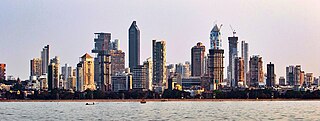
Mumbai is the capital city of the Indian state of Maharashtra. Mumbai is the financial capital and the most populous city of India with an estimated population of 12.5 million (1.25 crore). Mumbai is the centre of the Mumbai Metropolitan Region, the sixth-most populous metropolitan area in the world with a population of over 23 million living within the Mumbai Metropolitan Region. Mumbai lies on the Konkan coast on the west coast of India and has a deep natural harbour. In 2008, Mumbai was named an alpha world city.

Thane is a metropolitan city located on the northwestern side of the state of Maharashtra in India. It is an immediate neighbour of Mumbai city proper, and a part of the Mumbai Metropolitan Region. It is situated in the north-eastern portion of the Salsette Island.
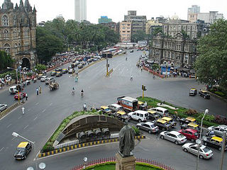
Transport in Mumbai is achieved by both public, and private transport. As of 2015, 52% of commuters use public transport. Mumbai has the largest organized bus transport network among major Indian cities.

Thane district is a district in the Konkan Division of Maharashtra, India. At the 2011 Census it was the most populated district in the country, with 11,060,148 inhabitants; however, in August 2014 the district was split into two with the creation of a new Palghar district, leaving the reduced Thane district with a 2011 Census population of 8,070,032. The headquarters of the district is the city of Thane. Other major cities in the district are Navi Mumbai, Kalyan-Dombivli, Mira-Bhayander, Bhiwandi, Ulhasnagar, Ambarnath, Badlapur, Murbad and Shahapur.

The Mumbai Metro is a rapid transit (MRT) system serving the city of Mumbai and the wider Mumbai Metropolitan Region in Maharashtra, India.

Alibag, also known as Alibaug, is a coastal city and a municipal council in Raigad district of Maharashtra, India. It is the headquarters of the Raigad district and is south of the city of Mumbai. Alibag is part of the Mumbai Metropolitan Region and is situated at a distance of about 96 km from Mumbai and 143 km from Pune. Alibag is a holy place for Goddess Shree Padmakshi Renuka. She is also known as goddess of Konkan.
Mira Road is a suburb north of Mumbai in Thane District and is also a part of the Mumbai Metropolitan Region. It falls within the Police Jurisdiction of Mira-Bhayander, Vasai-Virar Police Commissionerate. Mira Road is situated in the north-western portion of Salsette Island, Maharashtra state, India. Mira Road has a large Gujarati population followed by Marathis along with other ethnic groups.
Palghar is a town in the Konkan division of Maharashtra state, India and a municipal council. It is in the Mumbai Metropolitan Region, and since 2014 it has been the administrative capital of the Palghar district. Palghar lies on the Western Line of the Mumbai Suburban Railway in the busy Mumbai-Ahmedabad rail corridor. The town is located about 87 kilometers north of Mumbai, about 35 kilometers north of Virar and about 24 kilometers west of the Mumbai-Ahmedabad National Highway at Manor.

Virar is a coastal city in taluka Vasai and district of Palghar, in India's Maharashtra state. It is clubbed into Vasai-Virar city, administered by Vasai-Virar Municipal Corporation. It lies in south part of Palghar District in Vasai Taluka and north to the city of Mumbai. It is an important part of Palghar District because Palghar is the outermost part of northern side of Mumbai Metropolitan Region and comes under Police Jurisdiction of Mira-Bhayander, Vasai-Virar Police Commissionerate.
Mumbai, often described as the New York of India, is the financial capital and the most populous city of India with an estimated city proper population of 12.5 million (1.25 crore). The city is the entertainment, fashion, and commercial centre of India. Mumbai hosts the largest urban economy of any city in India. As of 2021, Mumbai Metro's nominal GDP is estimated to be US$277.980 billion, and GDP (PPP) is estimated to be US400 billion, Mumbai's GDP (PPP) per capita rounds up to around US$23,000. It is the richest Indian city and 12th richest city in the world with a net wealth of around US$1 trillion with 46,000 millionaires and 48 billionaires. Mumbai accounts for slightly more than 6.16% of India's economy, contributing 10% of factory employment, 30% of income tax collections, 45% of entertainment tax, 60% of customs duty collections, 20% of central excise tax collections, 40% of foreign trade, 100% of stock market assets and rupees 1,60,000 crore in corporate taxes to the Indian economy.

The Konkan Division is one of the six administrative divisions of Maharashtra state in India. It comprises the central portions of the Konkani region excluding Goa and Damaon, which were absorbed into Maharashtra owing to the States Reorganisation of India. Konkan Division is the western section of present-day Maharashtra, along the west coast of India. The two districts of the state capital Mumbai also fall into this division.
Vasai-Virar is an agglomeration of four previously governed municipal councils: Vasai (Bassein), Virar, Nallasopara and Navghar-Manikpur, as well as a few towns to the east and west of the urban area. It lies in the Konkan division of Maharashtra, India.

Maharashtra Police is the law enforcement agency responsible for the Indian state of Maharashtra. It is headed by Director General of Police, Mrs. Rashmi Shukla (IPS), and headquartered in Mumbai, Maharashtra.
The Thane Municipal Corporation Transport Service, operating under the name "Thane Municipal Transport (T.M.T.)" is the transport wing of Thane Municipal Corporation, which operates many bus lines in the Thane metropolitan area. These buses are called Thane Municipal Transport or T.M.T bus. TMT bus serves the entire Thane City. It also has operation outside city limits into neighboring Mumbai, Bhiwandi, Navi Mumbai, Kalyan Dombivali, Mira-Bhayandar and Vasai Virar.
The Mumbai Metropolitan Region Development Authority (MMRDA) is a body of the Government of Maharashtra that is responsible for preparation of Regional Plan for MMR and the infrastructure development of the Mumbai Metropolitan Region. The MMRDA was created on 26 January 1975 under the Mumbai Metropolitan Region Development Authority Act, 1974 Government of Maharashtra. The agency is responsible for planning and coordination of development activities in the Region.

Palghar District is a district in the state of Maharashtra in Konkan Division. The headquarters of the district is the town of Palghar. Other major cities in the district are Vasai-Virar, Talasari, Jawhar and Dahanu.
Thane taluka is a taluka in Thane district of Maharashtra state in Konkan division.
The Vikhroli-Kopar Khairane Link Road (VKLR), also known as the JVLR-Kopar Khairane-Ghansoli Bridge, is a proposed 7.5 km to 10 km, freeway grade road bridge connecting the Indian city of Mumbai with Navi Mumbai, its satellite city. The new link road would start at Eastern Express Highway (EEH) where Jogeshwari–Vikhroli Link Road (JVLR) ends in Vikhroli, then cross Thane Creek and Harbour railway line and will terminate at Kopar Khairane in Navi Mumbai before ending on Thane-Belapur Road. The link would be a six-lane road of about 10 km in length including a 2-kilometre-long (1.2 mi) bridge over the Thane Creek. At present motorists have to take either the Vashi Bridge or Mulund-Airoli Link Road to go to Navi Mumbai and Pune. The new road will help motorists save time and fuel. The project is estimated to cost around ₹ 550 to 1200 crore. Mumbai Metropolitan Region Development Authority (MMRDA) appointed N P Bridging, as designing consultants for the project, which was supposed to submit the final report on the link road by mid-September 2016.

Red Line 9 (extension) of the Mumbai Metro is part of the metro system for the city of Mumbai, India. Metro Line 9 is an extension of the Red Line from Andheri to CSMIA and Dahisar to Mira Road. This line will be unique from the other metro lines because it will run on a double-decker bridge. There will be a flyover on the first deck and the metro will run on the second deck. The flyover will start near the proposed Shivaji Chowk metro station and will end in Bhayander (West) via Mira Bhayander Road. It shall provide interconnectivity among the Western Express Highway, the Western Line, and the Mumbai Metro.
Line 5 (Orange Line) of the Mumbai Metro is a rapid transit metro line in the city of Mumbai, Maharashtra, India. When completed, the 24.9 km (15.5 mi) line will connect Thane with Kalyan via Bhiwandi, with 17 stations. The line will be fully elevated except for a 3 km underground section in Bhiwandi.


