Aurangabad division Marathwada | |
|---|---|
| Chhatrapati Sambhajinagar division[ citation needed ] | |
 Aurangabad | |
| Coordinates: 19°53′19.63″N75°20′36.37″E / 19.8887861°N 75.3434361°E | |
| Country | |
| State | |
| Districts | |
| Government | |
| • Commissioner Aurangabad Division |
|
| • Police Commissioner Aurangabad Division | NA |
| • All Guardian Minister Aurangabad Division |
|
| • All District Collector's Aurangabad Division |
|
| • All MP's Aurangabad Division | NA |
| Area | |
• Total | 64,590.58 km2 (24,938.56 sq mi) |
| Population (2011) [1] | |
• Total | 18,731,872 |
| Languages [2] | |
| • Language | Marathi (official) Urdu Hindi Lambadi |
| Literacy | 76.49% [1] |
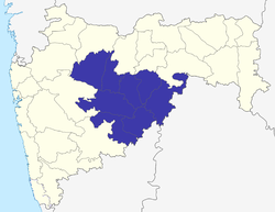
Aurangabad division, officially renamed as Chhatrapati Sambhajinagar division[ citation needed ] and also known as Marathwada division,[ citation needed ] is one of the six administrative divisions of the state of Maharashtra in India. It represents the Marathwada region of Maharashtra and is synonymous with it.