Pune division

Last updated

Paschim Maharashtra
Pune Division
Pune Division.png
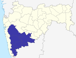
Location of Pune Division in Maharashtra
Coordinates: 18°31′48″N73°50′24″E / 18.53000°N 73.84000°E / 18.53000; 73.84000
Country India
State Maharashtra
Districts1. Pune, 2. Kolhapur, 3. Sangli, 4. Satara, 5. Solapur
Government
  Commissioner Pune DivisionNA
  Police Commissioner Pune DivisionNA
  All Guardian Minister Pune Division

(Pune District)

(Kolhapur District)

(Sangli District)

(Satara District)

(Solapur District)
  All District Collector's Pune Division
  • Mr. Dr. Rajesh Deshmukh (IAS)

(Pune District)

  • Mr. Rahul Rekhawar (IAS)

(Kolhapur District)

  • Mr. Dr. Abhijeet Chaudhari (IAS)

(Sangli District)

  • Mr. Shekhar Singh (IAS)

(Satara District)

  • Mr. Milind Shambharkar (IAS)
(Solapur District)
  All MP's Pune DivisionNA
Area
  Total58,268 km2 (22,497 sq mi)
  Under irrigation8,896 km2 (3,435 sq mi)
Population
 (2011 census)
  Total23,449,049
Literacy (2001 Census)76.95%
Main cropsJowar, wheat, bajra, sugarcane, rice, soybean, onion, groundnut, vegetables, turmeric, grape, pomegranate

Pune Division (better known as Paschim Maharashtra or Desh ) is one of the six administrative divisions of the Indian State of Maharashtra. Pune Division is bound by Konkan Division to the west, Nashik Division to the north, Aurangabad Division to the east, and the state of Karnataka to the south. [1]

Contents

It includes some of the most developed and most populous areas of Maharashtra.

Demographics

At the 2011 Census, Pune Division had a population of 23,449,049. [2] The region has a high literacy rate; higher than the national average. According to the 2011 Census, Pune district has a literacy rate of 86.15%, Satara 82.86%, Sangli 81.47%, Kolhapur 81.50% and Solapur 77.01%.

Languages

The most spoken language is Marathi, which is also the sole official language of the region. There are significant minorities of Hindi speakers as well as speakers of other regional languages such as Telugu, Kannada, Gujarati, Marwari and Bengali in the Urban areas. Kannada is also spoken by a large number of people in the regions bordering Karnataka. Urdu is spoken by the local Muslim population as well as migrants.

At the time of the 2011 Census of India, 81.90% of the population of Pune Division spoke Marathi, 6.88% Hindi, 3.30% Kannada, 2.33% Urdu, 0.97% Telugu, 0.71% Marwari and 0.65% Gujarati as their first language. [3]

Languages in Pune Division (2011) [3]

   Marathi (81.90%)
   Hindi (6.88%)
   Kannada (3.30%)
   Urdu (2.33%)
   Telugu (0.97%)
   Marwadi (0.71%)
   Gujarati (0.65%)
  Others (3.26%)

Religion

At the time of the 2011 Census of India, 86.99% of the population of Pune Division followed Hinduism, 7.62% Islam, 2.49% Buddhism, 0.74% Christianity and the remaining 2.16% of the population followed other religions or stated no religion. [2]

Religion in Pune Division (2011) [2]

   Hinduism (86.99%)
   Islam (7.62%)
   Buddhism (2.49%)
   Christianity (0.74%)
  Other or not stated (2.16%)

History of administrative districts in Pune Division

There have been changes in the names of districts and has seen also the addition of newer districts after India gained Independence in 1947 and also after the state of Maharashtra was formed.

Related Research Articles

<span class="mw-page-title-main">Solapur</span> City in Maharashtra, India

Solapur is a city located in the south-western region of the Indian state of Maharashtra, close to its border with Karnataka. Solapur is located on major highway, rail routes between Mumbai, Pune, Bangalore and Hyderabad, with a branch line to the cities of Kalaburagi and Vijayapura in the neighbouring state of Karnataka. Solapur International Airport is under construction. It is classified as A1 Tier and B-1 class city by House Rent Allowance (HRA) classification by the Government of India. It is the seventh biggest Metropolis Urban Agglomeration and 11th most populated city in Maharashtra as well as 43rd largest urban agglomeration and 49th most populous city in India.

<span class="mw-page-title-main">Central Railway zone</span> Zone of Indian Railways

Central Railway is one of the 19 zones of Indian Railways. Its headquarters is in Mumbai at Chhatrapati Shivaji Maharaj Terminus. It has the distinction of operating the first passenger railway line in India, which opened from Mumbai to Thane on 16 April 1853.

<span class="mw-page-title-main">Satara (city)</span> City in Maharashtra, India

Satara is a city located in the Satara District of Maharashtra state of India, near the confluence of the river Krishna and its tributary, the Venna. The city was established in the 16th century and was the seat of the Chhatrapati of Maratha Empire, Shahu I.

<span class="mw-page-title-main">Pandharpur</span> Town in Maharashtra

Pandharpur is a Popular pilgrimage town, on the banks of Chandrabhagā River, near Solapur city in Solapur District, Maharashtra, India. Its administrative area is one of eleven tehsils in the District, and it is an electoral constituency of the state legislative assembly. The Vithoba temple attracts about a million Hindu pilgrims during the major yātrā (pilgrimage) in Ashadha (June–July).

Malshiras is a town and the headquarters of Malshiras taluka in Solapur district of Maharashtra state in western India. Its governing body is promoted to Nagar Panchayat from a Gram Panchayat in 2017. There are many popular towns in Malshiras taluka such as Akluj, Natepute, Mahalung, Malinagar, Velapur and popular Villages like Rajapur (Islampur) Goradwadi, Bhamburdi, Medad and Palasmandal. Rajapur (Islampur) is adjacent to Malshiras which has good literacy rate and having historic samadhi mandir of Veer Santaji Ghorpade.

<span class="mw-page-title-main">Satara district</span> District of Maharashtra in India

Satara district is a district of Maharashtra state in western India with an area of 10,480 km2 (4,050 sq mi) and a population of 3,003,741 of which 14.17% were urban. Satara is the capital of the district and other major towns include Medha, Wai, Karad, Malkapur, Koregaon, Rahimatpur, Dahiwadi, Koynanagar, Phaltan, Lonand, Mahabaleshwar, Panchgani, Vaduj and Mhaswad. This district comes under Pune Administrative Division along with Pune, Sangli, Solapur and Kolhapur. The district of Pune bounds it to the north, Raigad bounds it to the north-west, Solapur the east, Sangli to the south, and Ratnagiri to the west.

<span class="mw-page-title-main">Sangli district</span> District of Maharashtra in India

Sangli district is a district of Maharashtra state in India. Sangli city is the district headquarters. It is bordered by Satara district, Solapur district to the North, Karnataka state to the South-East, by Kolhapur district to South-West and by narrow portion on the East side to Ratnagiri district. It is present on the southern tip of Maharashtra.

<span class="mw-page-title-main">Barshi</span> City in Maharashtra, India

Barshi is a city located in Barshi Sub district of Solapur District of Maharashtra State of Republic of India.

<span class="mw-page-title-main">Solapur district</span> District of Maharashtra in India

Solapur District is a district in Maharashtra state of India. The city of Solapur is the district headquarters. It is located on the south east edge of the state and lies entirely in the Bhima and Seena basins. The entire district is drained by the Bhima River.

<span class="mw-page-title-main">Karad</span> City in Maharashtra, India

Karad is a town in Satara district of Indian state of Maharashtra. It is located 302 km (180.19 miles) from Mumbai, 74 km from Sangli and 162 km from Pune. It lies at the confluence of Koyna River and the Krishna River known as the "Pritisangam". The two rivers originate at Mahabaleshwar, which is around 100 km from Karad. Karad is well known for sugar production and is known as the sugar bowl of Maharashtra owing to the presence of many sugar factories in and around Karad. It is considered an important educational hub in Western Maharashtra due to the presence of many prestigious educational institutes. Karad is resting place of the first chief minister of Maharashtra Yashwantrao Chavan situated at the confluence of the Krishna and Koyana rivers. It is ranked as the cleanest town in Swachh Survekshan 2020 in the category of population with less than 1 lakh.

Khatav is a town and taluka located in the Man-Khatav subdivision of the Satara district, India.

Walwa is a taluka in Sangli district in the Indian state of Maharashtra. It is also known as Walwa-Islampur Taluka. There are ninety-five panchayat villages in Walwa Taluka.

Jat is a town and taluka headquarters in Miraj subdivision of Sangli district in southern Maharashtra.

Kadegaon is a village and taluka of Sangli district of Maharashtra in India.

Atpadi is a taluka in Sangli district of Maharashtra, in 2022 it is one of the talukas of the district, belonging to the Vita sub-division of the district. In 2012 the taluka suffered a severe drought, reportedly the worst in living memory, similar conditions were faced in 2016 and 2019, in 2020 the taluka was hit by floods that caused losses to lives and properties. India's best quality pomegranates are grown in the taluka and the taluka is a pioneer amongst exporters of the fruit, though adverse climatic conditions and diseases have hit the growers. There is a proposal and demand that Sangli district be split to form a new Mandesh district, with Atpadi taluka being one of the talukas to be included in this new district.

<span class="mw-page-title-main">Baramati taluka</span>

Baramati taluka is a taluka in Baramati subdivision of Pune district of state of Maharashtra in India.

<span class="mw-page-title-main">Haveli taluka</span> Tehsil in Maharashtra, India

Taluka Haveli is a subdivision of the district of Pune, Maharashtra. The Pune Municipal Corporation & Pimpri Chinchwad Municipal Corporation, Pune are at the center of & entirely surrounded by the taluka for administrative purposes. The region of Pune Metropolitan Region has claimed the major part of the same.

Pune railway division is one of the five railway divisions of Central Railway (India) Zone of Indian Railways located at Pune of Maharashtra state in western India. The other railway divisions are Mumbai CSMT, Nagpur, Solapur and Bhusawal. There are 71 railway stations in Pune railway division.

<span class="mw-page-title-main">Ninam, Satara</span> Village in Maharashtra

Ninam is a census village in Satara district, in the Indian state of Maharashtra. It is a village surrounded by greenery and farms but also mountains. Agriculture is the main land use in the village with more than 75% of the total area being used for agricultural activities. The village close to historic Ajinkyatara fort, which is to the north. The large Jyotirlinga temple is in the center of the village.

<span class="mw-page-title-main">Vaduj</span> City in Maharashtra, India

Vaduj is a major town in Satara district of Maharashtra, India. It is the headquarters of Khatav Taluka. It is located on the banks of the Yerala River, and is around 58 kilometres (36 mi) away from the district capital Satara, and 165 kilometres (103 mi) away from Pune. It is the biggest town in Khatav Taluka, with a population of around 17,636 people. Recently, its status was changed to Nagar Panchayat.

References

  1. Rao; Prakash; Patil; Yogesh. Reconsidering the Impact of Climate Change on Global Water Supply, Use, and Management. IGI Global. p. 253. Retrieved 4 November 2016.
  2. 1 2 3 "Population By Religious Community". censusindia.gov.in. Retrieved 12 September 2023.
  3. 1 2 "Table C-16 Population by Mother Tongue: Maharashtra". censusindia.gov.in. Registrar General and Census Commissioner of India.