Ahmednagar

Last updated

Ahmednagar
City
Ahilya Nagar
Ahmednagarrailwaystation.jpg
Ahmednagar railway station
India Maharashtra location map.svg
Red pog.svg
Ahmednagar
India location map.svg
Red pog.svg
Ahmednagar
Coordinates: 19°05′N74°44′E / 19.08°N 74.73°E / 19.08; 74.73
CountryIndia
State Maharashtra
District Ahmednagar
Division Nashik
Founded1490
Founded by Ahmad Nizam Shah I
Named for Ahmad Nizam Shah I (formerly)
Ahilyabai Holkar (present)
Government
  Type Mayor–Council
  Body Ahmednagar Municipal Corporation
   Mayor Rohini Shendage (SS) [ citation needed ]
Area
  Total39.30 km2 (15.17 sq mi)
Elevation
649 m (2,129 ft)
Population
 (2011) [1]
  Total350,905
  Rank 124th
  Density8,900/km2 (23,000/sq mi)
Demonym Ahmednagarkar / Ahmednagari /Nagarkar (Marathi)
Languages
  Official Marathi
Time zone UTC+5:30 (IST)
PIN
414001, 414003
Telephone code0241
Vehicle registration MH-16, MH-17
Website ahmednagar.gov.in

Ahmednagar (officially Ahilya Nagar) [2] [3] is a city in, and the headquarters of, the Ahmednagar district, Maharashtra, India, about 120 km (75 mi) northeast of Pune and 114 km (71 mi) from Aurangabad.

Contents

Ahmednagar has several dozen buildings and sites from the Nizam Shahi period. [4] Ahmednagar Fort, once considered almost impregnable, was used by the British to house Jawaharlal Nehru (the first prime minister of India) and other Indian Nationalists before Indian independence. A few rooms there have been converted to a museum. During his confinement by the British at Ahmednagar Fort in 1944, Nehru wrote book The Discovery of India . [5] Ahmednagar is home to the Indian Armoured Corps Centre & School (ACC&S), the Mechanised Infantry Regimental Centre (MIRC), the Vehicle Research and Development Establishment (VRDE) and the Controllerate of Quality Assurance Vehicles (CQAV). Training and recruitment for the Indian Army Armoured Corps takes place at the ACC&S. [6]

Ahmednagar is a relatively small town and shows less development than the nearby western Maharashtra cities of Mumbai and Pune. Ahmednagar is home to 19 sugar factories and is also the birthplace of the cooperative movement.[ citation needed ] Due to scarce rainfall, the city often suffers from drought. Marathi is the primary language for daily-life communication. The city administration has recently published a plan of developing the city by year 2031. [7]

Etymology

Ahmednagar took its name from Ahmad Nizam Shah I, who founded the town in 1494 [8] on the site of a battlefield where he won a battle against superior Bahamani forces. [9] It was close to the site of the village of Bhingar. [9] With the breakup of the Bahmani Sultanate, Ahmad established a new sultanate in Ahmednagar, also known as Nizam Shahi dynasty. [10]

History

The town Ahmednagar was founded in 1494 by Ahmad Nizam Shah I on the site of a more ancient city, Bhingar. [8] With the breakup of the Bahmani Sultanate, Ahmad established a new sultanate in Ahmednagar, also known as Nizam Shahi dynasty. [11]

It was one of the Deccan sultanates, which lasted until its conquest by Mughal emperor Shah Jahan in 1636. Aurangzeb, the last Mughal emperor, who spent the latter years of his reign, 1681–1707, in the Deccan, died in Ahmednagar and is buried at Khuldabad, near Aurangabad in 1707, with a small monument marking the site.[ citation needed ]

In 1759, the Peshwa of the Marathas obtained possession of the place from Nizam of Hyderabad and in 1795 it was ceded by the Peshwa to the Maratha chief Daulat Rao Sindhia. In 1803 Ahmednagar was besieged by a British force under Richard Wellesley and captured. [8] It was afterward restored to the Marathas, but again came into the possession of the British in 1817, according to the terms of the Treaty of Poona, [8] and was known as Ahmednuggur.

In 19th century American Christian missionaries opened first modern schools in this town. According to a report there were four girls' school running under the superintendence of Cynthia Farrar around the 1850s. Mahatma Jyotirao Phule visited them and got inspired to open school for girls in Poona. Later, he enrolled his wife Savitribai Phule in Farrar's school in a teacher's training program. Farrar was from America and spent his entire life in Ahmednagar running her schools, these girls' schools were one of the first such kind in the country. [12]

On 31 May 2023, Eknath Shinde (the chief minister of Maharashtra) announced that Ahmednagar would be renamed "Ahilya Nagar", in honour of Ahilyabai Holkar [13] who was Rani of Indore, within the Maratha Confederacy in the late 18th-century. Deputy chief minister Devendra Fadnavis spoke at the same meeting, referring to Shinde's government as "pro-Hindutva", and asked Shinde to rename the district "Ahilyanagar"; Shinde replied: "The state government has accepted your demand to rename Ahmednagar as Ahilyadevi Holkar Nagar". [14] The BJP demanded that Ahmednagar be renamed. [15] Rais Shaikh (group leader of the Samajwadi Party in the Maharashtra Legislative Assembly) said that "The Maha Yuti government is implementing the 'Yogi pattern' of creating an illusion of development by changing the names of cities without doing anything for development" [3] and accused the government of "distorting history". [3] On 13 March 2024, the Maharashtra state cabinet announced that they had approved the renaming of Ahmednagar at the same time as they announced the renaming of seven railway stations in Mumbai. [2] [15]

Military base

Ahmednagar is home to:

Training and recruitment for the Indian Army Armored Corps take place at the ACC&S. Formerly, the city was the Indian base of the British Army's Royal Tank Corps/ Indian Armored Corps, amongst other units. The town houses the second-largest display of military tanks in the world and the largest in Asia. [16] [ failed verification ]

Geography

Climate

Situated in the rain shadow region of the Western Ghats, Ahmednagar has a hot semi-arid climate (Köppen BSh). The climate is hot throughout the year and sweltering during the pre-monsoon months from March to mid-June, whilst monsoon rainfall averages less than a third of that received in Mumbai and about a tenth what is received in Mahabaleshwar on the crest of the mountains.[ citation needed ]

Climate data for Ahmednagar (1981-2010, extremes 1901-2012)
MonthJanFebMarAprMayJunJulAugSepOctNovDecYear
Record high °C (°F)36.1
(97.0)
38.9
(102.0)
43.2
(109.8)
43.5
(110.3)
44.0
(111.2)
43.3
(109.9)
37.7
(99.9)
39.5
(103.1)
38.2
(100.8)
39.7
(103.5)
35.6
(96.1)
35.6
(96.1)
44.0
(111.2)
Mean daily maximum °C (°F)30.1
(86.2)
32.3
(90.1)
35.7
(96.3)
38.6
(101.5)
38.6
(101.5)
33.1
(91.6)
29.7
(85.5)
29.2
(84.6)
29.9
(85.8)
31.8
(89.2)
30.3
(86.5)
29.5
(85.1)
32.4
(90.3)
Mean daily minimum °C (°F)11.7
(53.1)
13.3
(55.9)
16.8
(62.2)
20.4
(68.7)
22.5
(72.5)
22.1
(71.8)
21.4
(70.5)
20.9
(69.6)
20.4
(68.7)
18.3
(64.9)
15.0
(59.0)
11.6
(52.9)
17.9
(64.2)
Record low °C (°F)1.8
(35.2)
2.8
(37.0)
7.5
(45.5)
9.5
(49.1)
15.2
(59.4)
17.0
(62.6)
16.5
(61.7)
12.2
(54.0)
10.7
(51.3)
10.6
(51.1)
5.6
(42.1)
3.3
(37.9)
1.8
(35.2)
Average rainfall mm (inches)0.3
(0.01)
0.8
(0.03)
1.9
(0.07)
4.1
(0.16)
22.7
(0.89)
124.5
(4.90)
90.9
(3.58)
99.6
(3.92)
186.9
(7.36)
72.0
(2.83)
24.8
(0.98)
6.8
(0.27)
635.4
(25.02)
Average rainy days0.00.30.30.51.36.46.05.08.84.21.00.434.3
Average relative humidity (%) (at 17:30 IST)37322623305868706857524348
Source: India Meteorological Department [17] [18]

Demographics

Religions in Ahmednagar city (2011) [19]
ReligionPercent
Hinduism
75.69%
Islam
15.64%
Jainism
4.35%
Christianity
2.57%
Buddhism
0.85%
Other or not stated
0.90%

As of 2011 Indian census, [20] Ahmednagar had a population of 350,859. Ahmednagar has a sex ratio of 961 females per 1000 males and an average literacy rate of 84%, higher than the national urban average of 79.9%. [21] 10% of the population is under 6 years of age.
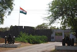
Languages of Ahmednagar city (2011) [22]

   Marathi (68.01%)
   Hindi (9.43%)
   Urdu (8.59%)
   Telugu (4.86%)
   Marwari (4.31%)
   Sindhi (1.35%)
   Gujarati (0.95%)
  Others (2.50%)

At the time of the 2011 Census of India, 68.01% of the population spoke Marathi, 9.43% Hindi, 8.59% Urdu, 4.86% Telugu, 4.31% Marwari, 1.35% Sindhi and 0.95% Gujarati as their first language. [22]

Notable people

Tourist places

[23]

Salabat Khan's tomb. Salabat Khan's Dome.png
Salabat Khan's tomb.
Ahmednagar fort entrance. Ahmednagar fort entrance.jpg
Ahmednagar fort entrance.
Samadhi of Meher Baba Meher Baba Samadhi2.jpg
Samadhi of Meher Baba

Transport

Air

Ahmednagar has 1 airport, the nearest domestic airport at Shirdi at 90km. While the nearest International Airport is at Pune.

Ahmednagar city has air connectivity by Seaplane service. The port for Seaplane is located at the Mula Dam water reservoir, 30 min away from Ahmednagar City. The service offered by Maritime Energy Heli Air Services Pvt. Ltd. (MEHAIR) from 22 September 2014. Ongoing Flight is available from Juhu, Mumbai to Mula Dam.[ citation needed ]

Rail

Ahmednagar railway station (station code:ANG) belongs to Solapur Division of Central Railway zone of the Indian Railways. Ahmednagar has rail connectivity with Pune, Manmad, Kopargaon, Shirdi, Daund, Goa, Nasik and other metro-cities like New Delhi, Mumbai, Chennai, Kolkata, Bangalore, Ahmedabad. 41 express trains stop at this station.[ citation needed ] There is still a demand for direct rail connectivity to other major cities of India. [28] Ahmednagar station will now be a part of the Pune railway division. 24 stations of the Daund-Ankai section will be merged with Pune railway division. The Daund-Ankai section is currently under the management of the Solapur railway division. The change to the Pune division will increase the chances of starting demu services between Ahmednagar and Pune stations. [29]

One of the oldest and important railway project of Ahmednagar railway station was kalyan-Ahmednagar railway project which was in planning stage since British regime. It was referred as 3rd ghat project. The survey of this project was carried out in 1973,2000, 2006, 2014 etc. This project was in pink book in 2010. unfortunately this project could not be completed. The alignment length of this project was 184 km and it could have been shortest route for marathwada, andhra and Telangana. The major challenge for this project was proposed 18.96 km tunnel in malshej ghat section. [30]

Malshej Kriti samiti is following for kalyan ahmednagar railway project. Kalyan-murbad section which is first phase of this project is already under survey stage. [31]

Survey of Ahmednagar-Aurangabad Railway line with 120 km length was also carried out in March 2021. The DPR Report of this project is under preparation. [32]

Ahmednagar-Karmala railway option is also getting explored. Ahmednagar railway station will become an important railway junction in future to the level similar to daund railway junction. Kalyan-Murbad-Ahmednagar line is also possible in future. [33]

Road

Ahmednagar is well connected by road with major cities of Maharashtra and other states. It has 4 lane road connectivity to:

National Highway 222 from Kalyan to Nirmal near Adilabad in Telangana passes through the city. The Maharashtra State Road Transport Corporation (MSRTC) and different private transport operators provide bus service connecting the city to all parts of the state.

Ahmednagar has 3 main bus stands:

Intra city transport

Politics

Ahmednagar Municipal Council was upgraded to a Municipal Corporation in 2003. As of 2022, Rohini Shendage of Shiv Sena was the incumbent mayor. Ahmednagar city is represented in the central and state legislatures by the Ahmednagar Lok Sabha and Ahmednagar City Vidhan Sabha seats respectively. The Sitting MP was Dr.Sujay Vikhe Patil as of 2022, while the sitting MLA was Sangram Jagtap.

Media and communication

Internet facilities are provided by several service providers.

Related Research Articles

<span class="mw-page-title-main">Aurangabad</span> Metropolis in Maharashtra, India

Aurangabad, officially known as Chhatrapati Sambhaji Nagar, or Chhatrapati Sambhajinagar, is a city in the Indian state of Maharashtra. It is the administrative headquarters of Aurangabad district and is the largest city in the Marathwada region. Located on a hilly upland terrain in the Deccan Traps, Aurangabad is the fifth-most populous urban area in Maharashtra after Mumbai, Pune, Nagpur and Nashik with a population of 1,175,116. The city is known as a major production center of cotton textile and artistic silk fabrics. Several prominent educational institutions, including Dr. Babasaheb Ambedkar Marathwada University, are located in the city. The city is also a popular tourism hub, with tourist destinations like the Ajanta and Ellora caves lying on its outskirts, both of which have been designated as UNESCO World Heritage Sites since 1983. Other tourist attractions include the Aurangabad Caves, Devagiri Fort, Grishneshwar Temple, Jama Mosque, Bibi Ka Maqbara, Himayat Bagh, Panchakki and Salim Ali Lake. Historically, there were 52 Gates in Aurangabad, some of them extant, because of which Aurangabad is nicknamed as the "City of Gates". In 2019, the Aurangabad Industrial City (AURIC) became the first greenfield industrial smart city of India under the country's flagship Smart Cities Mission.

<span class="mw-page-title-main">Kalyan</span> City in Maharashtra, India

Kalyan is a city on the banks of Ulhas River in Thane district of Maharashtra state in Konkan division. It is governed by Kalyan-Dombivli Municipal Corporation. Kalyan is a subdivision (Taluka) of Thane district. Kalyan and its neighbouring township of Dombivli jointly form Kalyan-Dombivli Municipal Corporation, abbreviated as KDMC. It is a founding city of the Mumbai Metropolitan Region. Kalyan is the 7th biggest city in Maharashtra and 29th in India. Kalyan also serves as a major railway station for the trains bound to Mumbai and is a large junction separating two routes, one going Karjat and other Kasara.

<span class="mw-page-title-main">Central Railway zone</span> Zone of Indian Railways

Central Railway is one of the 19 zones of Indian Railways. Its headquarters is in Mumbai at Chhatrapati Shivaji Maharaj Terminus. It has the distinction of operating the first passenger railway line in India, which opened from Mumbai to Thane on 16 April 1853.

<span class="mw-page-title-main">Ratnagiri</span> City in Maharashtra, India

Ratnagiri is a port city on the Arabian Sea coast in Ratnagiri District in southwestern Maharashtra, India. The district is part of Konkan division of Maharashtra. The city is known for the Hapus or Alphonso mangoes. Ratnagiri is the birthplace of Indian independence activist Lokmanya Tilak. Thibaw, the last king of Burma, alongside his consort Supayalat and two infant daughters were exiled to a two-storied brick mansion in Ratnagiri. The building is now known as Thibaw Palace. This place has many villages like Karla, Rajiwada, Mirkarwada, etc.

<span class="mw-page-title-main">Akola</span> City and District Headquarter in Maharashtra, India

Akola is a major city in the Vidarbha region of the Indian state of Maharashtra. The third largest city in Eastern Maharashtra after Nagpur and Amravati, it is located about 580 kilometres (360 mi) east of the state capital, Mumbai, and 250 kilometres (160 mi) west of the second capital, Nagpur. Akola is the administrative headquarters of the Akola district located in the Amravati division.

<span class="mw-page-title-main">Daulatabad Fort</span> 12th-century fort in Maharashtra, India

DaulatabadFort originally DeogiriFort, is a historic fortified citadel located in Daulatabad village near Aurangabad, Maharashtra, India. It was the capital of the Yadavas, for a brief time the capital of the Delhi Sultanate, and later a secondary capital of the Ahmadnagar Sultanate.

<span class="mw-page-title-main">Pune district</span> District in Maharashtra, India

Pune district is a district in Western Maharashtra with Administrative Headquarters in Pune city. Pune district is the most populous district in the Indian state of Maharashtra. It is one of the most industrialised districts in India.

Daund is a city, municipal council, and headquarters of the Daund tehsil in the Pune district in the state of Maharashtra, India. The city of Daund is located on the Bhima River.

Chakan is a census town in India, in Pune district of the Indian state of Maharashtra. While agriculture remains an important factor, the town's industrial development is quickly urbanizing the area. The Independent referred Chakan as India's "Motor City".

<span class="mw-page-title-main">Jalna, Maharashtra</span> City in Maharashtra, India

Jalna is a city in Jalna district in the Aurangabad Division, or Marathwada region, of the Indian state of Maharashtra. It was part of Hyderabad State as a tehsil of Aurangabad district, before Jalna district was formed effective 1 May 1981.

<span class="mw-page-title-main">Hadapsar</span> Suburb in Pune, Maharashtra, India

Hadapsar is a developed town in eastern Pune City, Maharashtra, India. After 1990, Hadapsar developed into a major industrial area and is now one of the most densely populated and developed areas of Pune District. It is well connected to all parts of city. Distances to popular city centers is: Pune Railway Station 8 km, Lohegaon Airport 8 km, Koregaon Park 5 km, Swargate Bus Stand 7 km and Shivaji Nagar Railway Station 12 km.

<span class="mw-page-title-main">Mahatma Phule Krishi Vidyapeeth</span> Agricultural university in Indian state of Maharashtra.

The Mahatma Phule Krishi Vidyapeeth, Rahuri is a university established on March 29, 1968. It became operational in October 1969. Thirty-three kilometers to the south is Ahmednagar city and fifty kilometers to the north is Shirdi. Newasa, land of saint Dnyaneshwar is 33 km from Rahuri. Ahmednagar is a historical city and was the capital of the Nizam rulers. It is famous for co-operative sugar and dairy industries. The annual average maximum and minimum temperature range between 30 and 40 °C and 10 to 20 °C. respectively.

Savedi is a suburb in the northern part of Ahmednagar in the Indian state of Maharashtra. The All India Radio centre and the TV Centre of Prasar Bharati are located in this area.It is Biggest Suburban city of Ahmednagar.Savedi is Enriched With great Facilities With Shops and Mall It also has Very Good Health facilities and Food Courts like Cafe and Hotels,It has Upcoming Kohinoor Mall and D Mart Mall,It is Mainly Connected By Roads Like Pipeline Road,Gulmohar Road,Kushtadham Road,Lekhanagar Road

<span class="mw-page-title-main">Pune Junction railway station</span> Railway station in Maharashtra, India

Pune Junction railway station is the main railway junction of the city of Pune, India. It is one of the major railway junctions in Maharashtra. Pune Junction consists of 6 platforms. It also has a suburban train network.

Ranjangaon Mashid is a village in Parner taluka in Ahmednagar district of state of Maharashtra, India.

<span class="mw-page-title-main">Ahmednagar Junction railway station</span> Rail station in Maharashtra, India

Ahmednagar Junction serves Ahmednagar in Ahmednagar district in the Indian state of Maharashtra

<span class="mw-page-title-main">Solapur railway station</span> Railway station in Maharashtra, India

Solapur railway station is located in Solapur district in the Indian state of Maharashtra and serves Solapur city and the industrial belt around it. It is headquarters of Solapur Railway Division and a part of Central Railway zone.

<span class="mw-page-title-main">Aurangabad railway station</span> Railway Station in Maharashtra, India

Aurangabad railway station is a railway station located on the Kacheguda–Manmad section which mainly services Aurangabad City. This railway station comes under the Nanded division of the South Central Railway zone and has rail connectivity with major cities such as Parbhani, Nanded, Hyderabad, Delhi, Nizamabad, Nagpur, Nasik, Pune, Gangakhed, Purna, Udgir, Raichur jn, Ahmedabad, Ahmednagar, Kadpa, and Latur Road.

<span class="mw-page-title-main">Islam in Maharashtra</span>

Islam is the second largest religion in Maharashtra, India, comprising 12,971,152 people which is 11.54% of the population. Muslims are largely concentrated in urban areas of the state, especially in Mumbai and the Marathwada region. There are several groups of Muslims in Maharashtra: Marathi and Konkani Muslims, whose native language is various dialects of Marathi and Konkani, Dakhni Muslims, whose native language is Dakhni Urdu, and more recent Urdu-speaking migrants from North India.

Vambori or Wambori is a Panchyat town located in Rahuri Tehsil and, fall under Ahilya Nagar district, Maharashtra State, India.

References

  1. "Cities having population 1 lakh and above" (PDF). censusindia. The Registrar General & Census Commissioner, India. Retrieved 29 December 2012.
  2. 1 2 "Ahmednagar renamed as Ahilya Nagar: Maharashtra Cabinet approves name change". The Economic Times . 13 March 2024.
  3. 1 2 3 Marpakwar, Chaitanya (13 March 2024). "Maharashtra cabinet approves renaming of Ahmednagar to Ahilyanagar". The Times of India. ISSN   0971-8257 . Retrieved 15 March 2024.
  4. Sohoni, Pushkar (2015). Aurangabad with Daulatabad, Khuldabad, and Ahmadnagar. London; Mumbai: Deccan Heritage Foundation; Jaico. ISBN   9788184957020.
  5. Moraes, Frank (1 January 2007). Jawaharlal Nehru. Jaico Publishing House. p. 319. ISBN   978-81-7992-695-6.
  6. Sainik Samachar: The Pictorial Weekly of the Armed Forces. 1988. p. 14.
  7. Nagarick (6 June 2007). "Ahmednagar by year 2031". Nagarick.blogspot.com. Retrieved 23 November 2011.
  8. 1 2 3 4 Chisholm, Hugh, ed. (1911). "Ahmednagar"  . Encyclopædia Britannica . Vol. 1 (11th ed.). Cambridge University Press. p. 432.
  9. 1 2 The Kingdom of Ahmadnagar. Motilal Banarsidass. 1966. p. 38. ISBN   978-81-208-2651-9.
  10. Sen, Sailendra (2013). A Textbook of Medieval Indian History. Primus Books. pp. 118–119. ISBN   978-9-38060-734-4.
  11. Sohoni, Pushkar (2018). The Architecture of a Deccan Sultanate: Courtly Practice and Royal Authority in Late Medieval India. London: I.B. Tauris. ISBN   9781784537944.
  12. "Cynthia Farrar — Missionary woman who inspired Jotirao Phule". 28 January 2023.
  13. "Maharashtra's Ahmednagar to be renamed as Ahilya Nagar, announces CM Eknath Shinde". Hindustan Times . 31 May 2023.
  14. Kulkarni, Dhaval S. (3 June 2023). "Why Ahmednagar district in Maharashtra was renamed Ahilyanagar". India Today . Retrieved 24 August 2023.
  15. 1 2 "Ahmednagar becomes Ahilya Nagar, Maharashtra Cabinet approves name change". Hindustan Times . 13 March 2023.
  16. "The History of Ahmednagar". Ahmednagar.nic.in. 15 August 1947. Archived from the original on 7 October 2011. Retrieved 23 November 2011.
  17. "Station: Ahmednagar Climatological Table 1981–2010" (PDF). Climatological Normals 1981–2010. India Meteorological Department. January 2015. pp. 15–16. Archived from the original (PDF) on 5 February 2020. Retrieved 30 March 2020.
  18. "Extremes of Temperature & Rainfall for Indian Stations (Up to 2012)" (PDF). India Meteorological Department. December 2016. p. M135. Archived from the original (PDF) on 5 February 2020. Retrieved 30 March 2020.
  19. "Population by Religion - Maharashtra". censusindia.gov.in. Registrar General and Census Commissioner of India. 2011.
  20. "Census of India 2001: Data from the 2001 Census, including cities, villages and towns (Provisional)". Census Commission of India. Archived from the original on 16 June 2004. Retrieved 1 November 2008.
  21. Ministry of Home Affairs, Government of India, "2001 Literacy Rates", Census of India 2001, Ministry of Home Affairs, India
  22. 1 2 "Table C-16 Population by Mother Tongue: Maharashtra (Town level)". censusindia.gov.in. Registrar General and Census Commissioner of India.
  23. "Welcome to Mahatma Phule Krishi Vidyapeeth". Archived from the original on 6 September 2013. Retrieved 12 September 2013. Official website
  24. "Ahmednagar City". ahmednagar.nic.in.
  25. Rajendra Rajan Fort that held Nehru The Tribune , 12 July 2009
  26. Tank Museum at ahmednagar.nic.in
  27. "Maharashtra Krishi Vidyapeeth, Rahuri". Archived from the original on 6 September 2013. Retrieved 12 September 2013.
  28. "MPs demand better railway connectivity in Maharashtra". The Times of India. 23 February 2012. Retrieved 25 June 2023.
  29. Dheeraj Bengrut (3 November 2021). "Pune railway division area to increase, 24 stations to be added". Hindustan Times . Retrieved 14 November 2021.
  30. "कल्याण-नगर रेल्वे हा विकासाचा मार्ग – Development route of Kalyan Ahmednagar railway". Maharashtra Times (in Marathi). 4 August 2017. Retrieved 14 November 2021.
  31. "संजीवनी देणारा माळशेज घाट रेल्वे मार्ग". 2 March 2016. Retrieved 25 June 2023.
  32. "Field survey for rail line begins today". The Times of India. 28 February 2021.
  33. "अहमदनगर-करमाळा नवीन रेल्वे मार्गाबाबत लवकरच निर्णयाची शक्यता". 2 November 2021.
  34. "ahmednagar bus stand – Google Search". google.co.in. Retrieved 26 October 2017.
  35. "Bus Stands & Traffic Control Centers Ahmednagar".