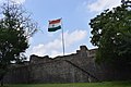
Ahmednagar Fort

Last updated

Ahmednagar fort
Ahmednagar, Maharashtra
Ahmednagar Fort Main Gate.jpg
India Maharashtra location map.svg
Red pog.svg
Ahmednagar fort
India location map.svg
Red pog.svg
Ahmednagar fort
Coordinates 19°05′41.3″N74°45′19.7″E / 19.094806°N 74.755472°E / 19.094806; 74.755472
TypeLand fort
Site information
OwnerIndian Military
Controlled by Ahmadnagar Sultanate (1562-1600)
Flag of the Mughal Empire (triangular).svg Mughal Empire (1600-1724)
Asafia flag of Hyderabad State.svg  Hyderabad (1724-1759)
Flag of the Maratha Empire.svg  Maratha (1759-1803)
Flag of the United Kingdom.svg  United Kingdom Flag of India.svg  India (1947-)
Open to
the public
daily 10am to 5pm
ConditionGood
Site history
MaterialsStone, mud, clay, cement
Demolishedyes
Battles/wars Siege of Ahmednagar
Garrison information
Past
commanders
Chand Bibi, Aurangzeb
Occupants Nana Phadanvis, Jawaharlal Nehru, Abul Kalam Azad, Sardar Patel

The Ahmednagar Fort (Ahmadnagar Qilaa) is a fort located close to the Bhingar Nala near Ahmednagar in [1] Maharashtra state western India. It was the headquarters of the Ahmednagar Sultanate. In 1803, it was taken by the British during the Second Anglo-Maratha War. It was used as a prison during the British Raj. Currently, the fort is under the administration of the Armoured Corps of the Indian Army.

Contents

Major features

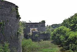
In 1803, the Ahmednagar Fort was round in appearance, with twenty-four bastions, one large gate, and three small sally ports. It had a glacis, no covered way; a ditch, revetted with stone on both sides, about 18 feet (5.5 m) wide, with 9 feet (2.7 m) water all around, which only reached within 6 or 7 feet (2.1 m) of the top of the scarp; long reeds grew in it all around. The berm was only about one yard wide. The rampart was of black hewn stone; the parapet of brick in chunam , and both together appeared from the crest of the glacis to be only as high as the pole of a field-officer's tent. The bastions were all about 4+12 feet higher; they were round. One of them mounted eight guns en barbet, pointing eastward; all the rest had jingies,[ check spelling ] four in each. In 1803 two guns were visible in each bastion, and 200 were said to be ready in the fort to be mounted. [2]

A gunshot to the west of the fort was the Pettah of Ahmednagar. The main gate of the fort faced the pettah, and was defended by a small half-circular work, with one traverse and several little towers for men. There was a wooden bridge over the ditch, which could be taken away in time of war, but it was not a drawbridge. It was reported that an iron trough as large as the bridge, could be placed upon it, or on the supporters of it, and fill with charcoal or other combustibles, to which could be ignited as an enemy approached. [2] The fort is also called as Bhuikot Killa which means it is a land fort and is not constructed on any hill. [3] It should not be confused with other Bhuikot Killas in Maharashtra like Solapur Bhuikot Killa.

A small river came from the northward, round the west side of the pettah, and passed to the southward of the fort. A nullah also passed from the northward, between the fort and a town called Bhingar, about a gunshot to the eastward, and joined the river. A potential defensive weakness was a little hill or rising ground close to and east of Bhingar, from which shot from siege guns could reach the fort. [2]

Two nills or covered aqueducts came from the hills, a mile or more to the north, passed through and supplied the pettah and the town, and then went into the fort, either under or through the ditch, into which the wastewater fell. [2]

There were no passages across the ditch from the sally ports, and no part of the aqueducts appeared above the ditch. The nullah mentioned above had steep banks and passed within 60 yards of the fort; the aqueduct from Bhingar passed under it. There was no bridge or even a prominent crossing point at the nullah and hence no clearly defined route between the fort and the town of Bhingar. [2]

There were many small pagodas and mosques around the pettah and the fort, but none exactly between, or between the fort and Bhingar, or nearer to the fort than those towns. [2]

History

Dumree Musjid, with Ahmednagar Fort in the background on the left side GRAY(1852) pg339 AHMEDNUGGUR - DUMREE MUSJID.jpg
Dumree Musjid, with Ahmednagar Fort in the background on the left side

The fort was built by Malik Ahmad Nizam Shah I (after whom the city of Ahmednagar is named) in 1427. [4] He was the first sultan of the Nizam Shahi dynasty and he built the fort to defend the city against invaders from neighbouring Idar. [4] Initially it was made of mud but major fortification began in 1559 under Hussain Nizam Shah. It took four years and was finally finished in 1562. [5] In February 1596, Chand Bibi the queen regent successfully repulsed the Mughal invasion but when Akbar attacked again in 1600 the fort went to the Mughals. [5] [6] [7] [8]

Aurangzeb died at Ahmednagar fort at the age of 88 on 20 February 1707. After Aurangzeb's death, the fort passed to the Nizams in 1724, to Marathas in 1759 and later the Scindias in 1790. During the period of instability in the Maratha Empire following the death of Madhavrao II, Daulat Scindia had the fort and its surrounding region ceded to him. In 1797, he imprisoned Nana Phadanvis the Peshwa diplomat at Ahmednagar fort. [9]

In 1803, during the Second Anglo-Maratha War, Arthur Wellesley defeated the Maratha forces and the East India Company came into possession of the fort.[ citation needed ]

Modern era

The fort was known as Ahmednagar Fort and was used by the British Raj as a prison and this was where Jawaharlal Nehru, Abul Kalam Azad, Sardar Patel and nine other members of the Indian National Congress were detained for almost three years after they passed the Quit India Resolution. [10] [11] Jawaharlal Nehru wrote his popular book -the Discovery of India- while he was imprisoned at the fort. [6] [11] [12] During the same time, Congress leader, Maulana Abul Kalam Azad also compiled his acclaimed "Ghubar-e-Khatir" (Sallies of Mind) (Urdu : غبار خاطر) which is considered as the best example of "Epistolary Essays" in Urdu literature.[ citation needed ]

During the same time, Odisha's first Chief-Minister and ex-Governor of undivided Bombay State, Harekrushna Mahatab also compiled three volumes of the History of Odisha in Odia. This has later been translated and published in English and Hindi.[ citation needed ]

Currently, the fort is under the administration of the Armoured Corps of the Indian Army. [11]

See also

Related Research Articles

<span class="mw-page-title-main">Ahmednagar</span> City in North Maharashtra, India

Ahmednagar is a city in, and the headquarters of, the Ahmednagar district, Maharashtra, India, about 120 km (75 mi) northeast of Pune and 114 km (71 mi) from Aurangabad.

<span class="mw-page-title-main">Maratha Empire</span> 1674–1818 empire in the Indian subcontinent

The Maratha Empire was an early modern Indian empire and later a confederation that controlled large portions of the Indian Subcontinent in the 18th century. Maratha rule formally began in 1674 with the coronation of Shivaji of the Bhonsle dynasty as the Chhatrapati. Although Shivaji came from the Maratha caste, the Maratha empire also included warriors, administrators, and other nobles from the Maratha and several other castes from what is known today as Maharashtra. The Maratha Kingdom was expanded into a full-fledged Empire in the 18th Century under the leadership of Peshwa Bajirao I.

<i>The Discovery of India</i> Book by Jawaharlal Nehru

The Discovery of India was written by the Indian freedom fighter Jawaharlal Nehru during his incarceration in 1942–1945 at Ahmednagar Fort in present-day Indian state of Maharashtra by British colonial authorities before the independence of India. The book was written in 1944 but published in 1946.

<span class="mw-page-title-main">Second Anglo-Maratha War</span> Conflict between the British East India Company and the Maratha Empire

The Second Anglo-Maratha War (1803–1805) was the second conflict between the British East India Company and the Maratha Empire in India. It resulted in major loss of territory for the Marathas, including regions around Delhi and in present-day Gujarat falling into direct Company rule.

<span class="mw-page-title-main">Berar Province</span> British Indian province under the nominal sovereignty of Hyderabad State

Berar Province, also known as the Hyderabad Assigned Districts, was a province of Hyderabad. After 1853, it was administered by the British, although the Nizam retained formal sovereignty over the province. Azam Jah, the eldest son of the 7th Nizam, held the title of Mirza-Baig ("Prince") of Berar.

<span class="mw-page-title-main">Battles involving the Maratha Empire</span>

The Maratha Conquests were a series of conquests in the Indian subcontinent which led to the building of the Maratha Empire. These conquests were started by Shivaji in 1659, from the victory at the Battle of Pratapgad against Bijapur. The expansion of the empire was limited and interrupted by the Mughal conquests of south India by Mughal ruler Aurangzeb until he eventually died in 1707 in Deccan itself. Marathas were forced to defend their territories against the overwhelmingly strong Mughal army in the 27 years long Deccan wars. They were able to defend their territories and gain an upper hand over Mughals in the sustained conflict.

Chakan is a census town in India, in Pune district of the Indian state of Maharashtra. While agriculture remains an important factor, the town's industrial development is quickly urbanizing the area. The Independent referred Chakan as India's "Motor City".

<span class="mw-page-title-main">Purandar Fort</span> Fort in Maharashtra, India

Purandar Fort is a mountain fort in Pune district in Western Indian state of Maharashtra, India. The fort stands at 1,374 metres (4,508 ft) above the sea level in the Western Ghats, 50 kilometres (31 mi) to the southeast of Pune.

<span class="mw-page-title-main">Panhala Fort</span> Medieval fort in Maharashtra, India

Panhala fort, is located in Panhala, 20 kilometres northwest of Kolhapur in Maharashtra, India. It is strategically located looking over a pass in the Sahyadri mountain range which was a major trade route from Bijapur in the interior of Maharashtra to the coastal areas. Due to its strategic location, it was the centre of several skirmishes in the Deccan involving the Marathas, the Mughals and the British the grand son's of chhatrapati shivaji maharaj East India Company, the most notable being the Battle of Pavan Khind. Here, the queen regent of Kolhapur, Tarabai Ranisaheb, spent her formative years. Several parts of the fort and the structures within are still intact. It is also called as the 'Fort of Snakes' as it is zigzagged in shape.

<span class="mw-page-title-main">Korlai Fort</span> Fort in Maharashtra, India

Korlai Fort is a colonial fort in the Raigad district of Maharashtra, India. Formerly a part of Chaul in Portuguese India, the structure is a specimen of Portuguese colonial architecture. It was built as a companion to the fort at Chaul, at this strategic position the Portuguese could use it to defend their province which stretched from Korlai to the Fort Bassein. Vestiges of the Portuguese occupation are manifested in the distinct dialect of the Korlai villages inhabitants which is a Luso-Indian creole called Korlai Portuguese Creole.

In 1803 the Pettah of Ahmednagar, had forty bastions, or round towers: eight of them were large, with two guns in each; the remainder had only loopholes. There were twelve gates, without any detached works for defence. The walls were of mud, about 10 feet (3.0 m) high without a ditch.

Sherikasari is a newly separated small village from Alkuti village of Parner Taluka in Ahmednagar District of state of Maharashtra, India.


The Solapur Bhuikot Killa (Fort) is one of the major tourist locations in Solapur, Maharashtra. This fort is not only an ancient Muslim fort located in Solapur, but also one of the ancient historical and religious places in Maharashtra.

<span class="mw-page-title-main">Avchitgad</span>

Avchitgad is a fort located in the Sahyadri ranges of Maharashtra. The fort is situated near Roha in the Raigad district. At the base of this fort is a village called Medha and Padam - Kharapti.

<span class="mw-page-title-main">Muqarrab Khan</span> Khan Zaman Fath Jang Dakhini

Muqarrab Khan of Golconda, also known as Khan Zaman Fath Jang Dakhini, was an Indian Deccani Muslim, who was the most experienced commander of Qutb Shahi Dynasty, during the reign of Abul Hasan Qutb Shah. He is known for betraying Abul Hasan Qutb Shah during Siege of Golconda. He arrested Maratha Emperor Sambhaji at Sangameshwar.

The siege of Ahmednagar was the first battle of the Second Anglo-Maratha War fought between the Maratha Confederacy and the British East India Company.

<span class="mw-page-title-main">Paranda Fort</span> 15th-century Indian fort

Paranda Fort is situated in Paranda, a small town in the Osmanabad district in the state of Maharashtra, India. It is protected monument by the Archaeological Survey Of India. The fort may have been constructed in the 15th century by Mahmud Gawan or by Murtaza Nizam Shah II in the early 1600s. Paranda has great historical value and finde mention in Honnati inscription of Baka 1045 and also later a few of the Kalyan Chalukyan an copper plates. As well as in Yadava epigraphs, as Pallyanda Pratyandaka. The fort is attraction in this Paranda town and is known to have been built by Mahmud Gavan, the Prime Ministar of Muhammad Shah Bahmani 2.

<span class="mw-page-title-main">Architecture of the Bahmani and Deccan sultanates</span> Architecture of the Deccan Plateau, India

Deccani architecture, particularly the architecture of the Bahmani and Deccan Sultanates, is the architecture of the Deccan Plateau, and is a regional variant of Indo-Islamic architecture. It was heavily influenced by the styles of the Delhi Sultanate and later Mughal architecture, but sometimes also directly influenced from Persia and Central Asia.

Hatgad Fort is a fort located 71 km (44 mi)from Nashik, Nashik district, of Maharashtra. The base village is Hatgad on the Nashik-Saputara Road. The nearest town is Saputara, which is 6 km from Hatgad village. It is a historic monument located in Maharashtra, India, south of the hill station of Saputara and near the border with Gujarat. It was built by the Maratha king Shivaji and is located at an elevation of about 3,600 feet. The way to reach the fort is through a trekking route via a narrow rocky path and car also go up to the stairs of fort. A statue of Lord Shivling is placed on the top of the fort.

<span class="mw-page-title-main">Islam in Maharashtra</span>

Islam is the second largest religion in Maharashtra, India, comprising 12,971,152 people which is 11.54% of the population. Muslims are largely concentrated in urban areas of the state, especially in Mumbai and the Marathwada region. There are several groups of Muslims in Maharashtra: Marathi and Konkani Muslims, whose native language is various dialects of Marathi and Konkani, Dakhni Muslims, whose native language is Dakhni Urdu, and more recent Urdu-speaking migrants from North India.

References

  1. In some older references Fort of Ahmednuggur
  2. 1 2 3 4 5 6 PD-icon.svg This article incorporates text from this source, which is in the public domain :Wellesley (Duke of Wellington), Arthur Richard (1859). "Memorandum of the Ahmednuggur Fort". In J. Murray (ed.). Supplementary despatches and memoranda of field marshal Arthur duke of Wellington 1797-1819 with a map of India. p.  100.
  3. "Ahmednagar Fort (Bhuikot Fort) - Total Safari".
  4. 1 2 Gazetteer of the Bombay Presidency. Govt Central Press. 1896. p. 238. Retrieved 10 March 2009.
  5. 1 2 Cowley, Capt Cecil (1919). "IX". Tales of Ahmednagar. Bombay: Thacker and Company Ltd.
  6. 1 2 "Ahmednagar fort". Maharashtra Tourism Development Corporation. Retrieved 10 March 2009.
  7. Sen, Sailendra (2013). A Textbook of Medieval Indian History. Primus Books. p. 164. ISBN   978-9-38060-734-4.
  8. Mehta, Jaswant L. (1990). Advanced study in the history of medieval India. Sterling Publ. p. 271. ISBN   9788120710153. OCLC   633709290.
  9. Gazetteer of the Bombay Presidency. Govt. Central Press. 1884. p. 409. Retrieved 10 March 2009.
  10. Mufti, Amir (2007). "3". Enlightenment in the Colony. Princeton University Press. pp. 129–130. ISBN   978-0-691-05732-3 . Retrieved 10 March 2009.
  11. 1 2 3 Gill, Himmat Singh (3 September 2006). "Where freedom held fort". The Sunday Tribune. Retrieved 10 March 2009.
  12. "Tribute in the thick of toil". The Telegraph-Calcutta. 15 August 2004. Archived from the original on 4 February 2013. Retrieved 10 March 2009.