Dindigul Fort

Last updated

Dindigul Rock Fort
Part of History of Tamil Nadu
Dindigul
24Dindigul.jpg
Dindigul in 1913
India Tamil Nadu location map.svg
Red pog.svg
Dindigul Rock Fort
Coordinates 10°21′40″N77°57′42″E / 10.36109°N 77.96167°E / 10.36109; 77.96167
TypeRock fort and temple complex
Height900 feet
Site information
Owner Archaeological Survey of India
Controlled by Archaeological Survey of India
Open to
the public
Yes
ConditionUnder renovation
Site history
Built1605
Built by Muthu Krishnappa Nayakkar
In usecirca early 1800s
MaterialsGranite

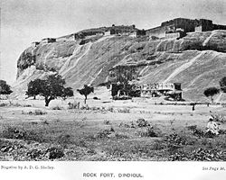
The Dindigul Fort or Dindigul Malai Kottai and Abirami amman Kalaheswarar Temple was built in 16th-century by Madurai Nayakar Dynasty situated in the town of Dindigul in the state of Tamil Nadu in India. The fort was built by the Madurai Nayakar king Muthu Krishnappa Nayakar in 1605. In the 18th century the fort passed on to Kingdom of Mysore (Mysore Wodeyars). Later it was occupied by Hyder Ali and Tipu Sultan the fort was of strategic importance. In 1799 it went to the control of the British East India Company during the Polygar Wars. There is an abandoned temple on its peak apart from few cannons sealed with balls inside. In modern times, the fort is maintained by the Archaeological Survey of India and is open to tourists.

Contents

Etymology

Dindigul Fort1.JPG
Dindigul Fort2.JPG

Dindigul city derives its name from a portmanteau of Thindu a Tamil word which means a ledge or a headrest attached to ground and kal another Tamil word which means Rock. Appar, the Saiva poet visited the city and noted it in his works in Tevaram . Dindigul finds mention in the book Padmagiri Nadhar Thenral Vidu thudhu written by the poet Palupatai sokkanathar as Padmagiri. This was later stated by U. V. Swaminatha Iyer (1855-1942) in his foreword to the above book. He also mentions that Dindigul was originally called Dindeecharam. [1]

History

Dindigul fort Dindigul Fort.jpg
Dindigul fort

Early Dindigul history

The history of Dindigul is centered on the fort over the small rock hill and fort. Dindigul region was the border of the three prominent kingdoms of South India, the Cheras, Cholas and Pandyas. During the first century A.D., the Chola king Karikal Cholan captured the Pandya kingdom and Dindigul came under the Chola rule. During the sixth century, the Pallavas took over most provinces of Southern India and Dindigul was under the rule of Pallavas until Cholas regained the state in the 9th century and the Pandyas regained control by the 13th century.

In the 14th century, half of Tamil Nadu kingdoms were under the short-reigned Delhi Sultanates with Madurai Sultanate ruling this region between 1335–1378. By end of 1378, the Muslim rulers were defeated by the Vijayanagara army who later established their rule.

Madurai Nayaks

Temple atop the fort Temple atop the Dindigul Fort.jpg
Temple atop the fort

In 1559 Madurai Nayaks, till then part of Vijayanagara empire became powerful and with Dindigul became a strategic gateway to their kingdom from North . After the death of King Viswanatha Nayak in 1563, Muthukrisna Nayakka became the king of kingdom in 1602 A.D who built the strong hill fort in 1605 A.D. He also built a fort at the bottom of the hill. Muthuveerappa Nayak and Thirumalai Nayak followed Muthukrishna Nayak. Dindigul came to prominence once again during Nayaks rule of Madurai under Thirumalai Nayak. After his immediate unsuccessful successors, Rani Mangammal became the ruler of the region who ruled efficiently. [1]

Under Mysore Rayas and Hyder Ali

In 1742, the Mysore army under the leadership of Venkata Raya conquered Dindigul. He governed Dindigul as a representative of Maharaja of Mysore. There were Eighteen Palayams (a small region consists of few villages) during his reign and all these palayams were under Dindigul Semai with Dindiguls capital. These palayams wanted to be independent and refused to pay taxes to venkatarayer. [1] [2] In 1748, Venkatappa was made governor of the region in place of Venkatarayer, who also failed. In 1755, Mysore Maharaja sent Haider Ali to Dindigul to handle the situation. Later Haider Ali became the de facto ruler of Mysore and in 1777, he appointed Purshana Mirsaheb as governor of Dindigul. He strengthened the fort. His wife Ameer-um-Nisha-Begam died during her delivery and her tomb is now called Begambur. In 1783 British army, led by captain long invaded Dindigul. In 1784, after an agreement between the Mysore province and British army, Dindigul was restored by Mysore province. In 1788, Tipu Sultan, the Son of Haider Ali, was crowned as King of Dindigul. [1] [3] [4] [5]

Under British

In 1790, James Stewart of the British army gained control over Dindigul by invading it in the second war of Mysore. In a pact made in 1792, Tipu ceded Dindigul along with the fort to the English. Dindigul is the first region to come under English rule in the Madurai District. In 1798, the British army strengthened the hill fort with cannons and built sentinel rooms in every corner. The British army, under statten stayed at Dindigul fort from 1798 to 1859. After that Madurai was made headquarters of the British army and Dindigul was attached to it as a taluk. Dindigul was under the rule of the British Until India got our Independence on 15 August 1947. [1] [3]

The fort played a major role during the Polygar wars, between the Palayakarars, Tipu Sultan duo aided by the French against the British, during the last decades of the 18th century. The polygar of Virupachi, Gopal Nayak commanded the Dindugal division of Polygars, and during the wars aided the Sivaganga queen Queen Velu Nachiyar and her commanders Maruthu Pandiyar Brothers to stay the fort after permission from Hyder Ali. [6]

Architecture

Dindigul Fort7.JPG
Dindigul Fort3.JPG

The rock fort is 900 ft (270 m) tall and has a circumference of 2.75 km (1.71 mi). Cannon and gunfire artillery were included in the fort during the 17th century. The fort was cemented with double walls to withstand heavy artillery. Cannons were installed at vantage points around the fort with an arms and ammunition godown built with safety measures. The double-walled rooms were fully protected against external threat and were well ventilated by round ventilation holes in the roof. A thin brick wall in one corner of the godown helped soldiers escape in case of emergency. The sloping ceiling of the godown prevented seepage of rainwater. The fort has 48 rooms that were once used as cells to lodge war prisoners and slaves, a spacious kitchen, a horse stable and a meeting hall for the army commanders. The fort also has its own rainwater reservoirs constructed by taking advantage of the steep gradient. The construction highlights the ingenuity of Indian kings in their military architecture. [7] [8]

Maintenance

The fort is maintained by the Archaeological Survey of India and maintains it as a protected monument. An entry fee of 25 is charged for Indian citizens and 300 for foreigners. The fort receives few visitors in college and school students and the occasional foreign tourists. Visitors are allowed to walk around the tunnels and trenches that reveals the safety features of the structure. The temple has some sculptures and carvings, with untarnished rock cuts.

Visitors can view the ruins within the fort walls, arsenal depots, or animal stables) and damaged halls decorated with carved stone columns. Visitors are allowed to go up to the cannon point and look through the spy holes. The top of the fort also offers a scenic view of Dindigul on the eastern side and villages and farmland on the other sides. Lack of funds and facilities has kept the fort misused by nearby dwellers. But in 2005, Keeranur-based ASI in Pudukkottai district fenced the entire surroundings and refurbished some of the dilapidated structures. [7] [9] [10]

Notes

  1. 1 2 3 4 5 "Historical moments". Dindigul municipality. 2011. Archived from the original on 29 July 2009. Retrieved 7 February 2016.
  2. Nelson 1989, p. 258
  3. 1 2 Nelson 1989, pp. 286-93
  4. Hasan, Mohibbul (2005). History of Tipu Sultan. Aakar Books. pp. 68–69. ISBN   81-87879-57-2.
  5. Beveridge, Henry (1867). A comprehensive history of India, civil, military and social, from the first landing of the English, to the suppression of the Sepoy revolt:including an outline of the early history of Hindoostan, Volume 2. Blackie and son. pp. 222–24.
  6. "Gopal Naicker Memorial ready for inauguration". The Hindu. Palani. 22 June 2012. Retrieved 7 February 2016.
  7. 1 2 Basu, Soma (2 April 2005). "Pillow Rock". The Hindu . Archived from the original on 28 June 2006. Retrieved 7 February 2016.
  8. "Cannonballs unearthed from Dindigul fort". The Hindu . 2 March 2004. Archived from the original on 24 June 2004. Retrieved 7 February 2016.
  9. "Alphabetical List of Monuments - Tamil Nadu". Archaeological Survey of India. 2011. Retrieved 7 February 2016.
  10. "List of ticketed monuments - Tamil Nadu". Archaeological Survey of India. 2011. Archived from the original on 18 August 2013. Retrieved 7 February 2016.

Related Research Articles

<span class="mw-page-title-main">Namakkal</span> Town in Tamil Nadu, India

Namakkal is a special grade municipality and the headquarters of Namakkal district in the Indian state of Tamil Nadu. It is the first ISO 14001-2004 certified municipality in Asia for environmental management, specifically the provision and maintenance of water supply, solid waste and sewage management, town planning, lighting and other social services. Namakkal is known as the Egg City due to its large egg production and Transport city.

<span class="mw-page-title-main">Carnatic region</span> Geographic region of southern India

The Carnatic region is the peninsular South Indian region between the Eastern Ghats and the Bay of Bengal, in the erstwhile Madras Presidency and in the modern Indian states of Tamil Nadu and southern coastal Andhra Pradesh. During the British era, demarcation was different, including Karnataka and the whole region south of Deccan with black soil.

<span class="mw-page-title-main">Polygar Wars</span> Indian conflict between the British East India Company and Polygars

The Polygar Wars or Palaiyakkarar Wars were wars fought between the Polygars (Palaiyakkarars) of the former Tirunelveli Kingdom in Tamil Nadu, India and the British East India Company forces between March 1799 to May 1802 or July 1805. The British finally won after carrying out gruelling protracted jungle campaigns against the Polygar armies. Many people died on both sides and the victory over the Polygars brought large parts of the territories of Tamil Nadu under British control, enabling them to get a strong hold in Southern India.

<span class="mw-page-title-main">Kongu Nadu</span> Geographical region in India

Kongu Nadu, also known by various names such as Kongu Mandalam and Kongu belt, is a geographical region comprising present day parts of western Tamil Nadu, southeastern Karnataka and eastern Kerala. In the ancient Tamilakam, it was the seat of the Chera kings, bounded on the east by Tondai Nadu, on the south-east by Chola Nadu and on the south by Pandya Nadu regions.

<span class="mw-page-title-main">Dindigul</span> City in Tamil Nadu, India

Dindigul, also spelt Thindukkal, is a city in the Indian state of Tamil Nadu. It is the administrative headquarters of the Dindigul district. Dindigul is located 420 km (260 mi) southwest from the state capital, Chennai, 100 km (62 mi) away from Tiruchirappalli, 66 km (41 mi) away from Madurai and 72 km away from the Tex City of Karur. The city is known for its locks and biryani. Parts of Dindigul Districts like Palani, Oddanchatram, Vedasandur, Nilakottai, Kodaikanal, Natham, Athoor.

<span class="mw-page-title-main">Pandya Nadu</span> Geographical region in India

Pandya Nadu or Pandi Nadu is a geographical region comprising the southern part of the present day state of Tamil Nadu. The region is bounded on its West by the Venad/Ay Nadu, Northeast by the Chola Nadu and Northwest by the Kongu Nadu. It comprises the present-day districts of Madurai, Theni, Sivaganga, Ramanathapuram, Virudhunagar, Tirunelveli, Tenkasi, Thoothukudi, Kanniyakumari, parts of Pudukkottai and Dindigul.

<span class="mw-page-title-main">History of Tamil Nadu</span> History of modern Indian state of Tamil Nadu

The region of Tamil Nadu in the southeast of modern India, shows evidence of having had continuous human habitation from 15,000 BCE to 10,000 BCE. Throughout its history, spanning the early Upper Paleolithic age to modern times, this region has coexisted with various external cultures.

Nilakkottai is a town in the Dindigul district of the Indian state of Tamil Nadu. The town was established in 1958, as 1st Grade Town Panchayat. In 1970, it was changed to Selection Grade. The Town Panchayat has been under the municipal act since 1996. In 2004, it was called Special Village Panchayat, and in 2006, Selection Grade Town Panchayat.

Sivagiri is a panchayat town and a tourist place in Tenkasi district in the Indian state of Tamil Nadu. Sivagiri is located at a distance of 50 km north to Tenkasi, 20 km south to Rajapalayam, 95 km north-west to Tirunelveli, 95 km south to Madurai, 540 km south to Bangalore, 150 km north to Thiruvananthapuram and 580 km south to the state capital Chennai.

<span class="mw-page-title-main">Vellore Fort</span> 16th-century fort in India

Vellore Fort is a large 16th-century fort situated in heart of the Vellore city, in the state of Tamil Nadu, India built by Vijayanagara kings. The fort was at one time the headquarters of the Aravidu Dynasty of the Vijayanagara Empire. The fort is known for its grand ramparts, wide moat and robust masonry.

<span class="mw-page-title-main">Madurai Nayak dynasty</span> Telugu dynasty that ruled Tamil Nadu with Madurai as capital

The Madurai Nayaks were a Telugu dynasty who ruled most of modern-day Tamil Nadu, India, with Madurai as their capital. The Nayak reign which lasted for over two centuries from around 1529 to 1736 was noted for its achievements in arts, cultural and administrative reforms, revitalization of temples previously ransacked by the Delhi Sultans, and the inauguration of a unique architectural style.

<span class="mw-page-title-main">Polygar</span> Regional administrators of south India

Palaiyakkarars, or Poligar, in Andhra and Tamil Nadu refers to the holder of a small kingdom as a feudatory to a greater sovereign. Under this system, palayam was given for valuable military services rendered by any individual. The word pālayam means domain, a military camp, or a small kingdom. This type of Palayakkarars system was in practice during the rule of Pratapa Rudhra of Warangal in the Kakatiya kingdom. The system was put in place in Tamilnadu by Viswanatha Nayaka, when he became the Nayak ruler of Madurai in 1529, with the support of his minister Ariyanathar. Traditionally there were supposed to be 72 Palayakkarars. The majority of those Palaiyakkarar, who during the late 17th- and 18th-centuries controlled much of the Telugu region as well as the Tamil area, had themselves come from the Kallar, Maravar and Vatuka, pala ekari communities.

<span class="mw-page-title-main">Sangagiri Fort</span>

Sankagiri Fort is a historical fort maintained by the Archaeological Survey of India. It is located 22 km from the city of Erode and 38 km from Salem. Sankari or Sankagiri is the town located around this place. The fort is 707 meters high and covers an area of 558.58 acres.

<span class="mw-page-title-main">Tiruchirappalli Rock Fort</span> Building in Tiruchirappalli, India

Tiruchirappalli Rockfort, locally known as Malaikottai, is a historic fortification and temple complex built on an ancient rock. It is located in the city of Tiruchirappalli, on the banks of river Kaveri, Tamil Nadu, India. It is constructed on an 83 metres (272 ft) high rock. There are two Hindu temples inside, the Ucchi Pillayar Temple, Rockfort and the Thayumanaswami Temple, Rockfort. Other local tourist attractions include the famous Pallava-era Ganesha temple and the Madurai Nayak-era fort. The fort complex has witnessed fierce battles between the Madurai Nayakas and Adil Shahi dynasty of Bijapur, Carnatic region and Maratha Imperial forces. The fort played an important part during the Carnatic Wars, helping lay the foundations of the British Empire in India. The Rockfort is the most prominent landmark of the city.

<span class="mw-page-title-main">Administrative divisions of Madras Presidency</span>

The Madras Presidency was a province of British India comprising most of the present day Tamil Nadu and Andhra Pradesh along with a few districts and taluks of Karnataka, Kerala and Odisha. A few princely states, notably Ramnad and Pudukkottai also merged into the Presidency at some or the other time. The Presidency lasted till 1950, when it became the Madras State after India became a republic. In 1953, Telugu-speaking regions of the state split to form Andhra State. Subsequently, in 1956, Kannada- and Malayalam-speaking areas were merged with Mysore and Travancore-Cochin respectively.

<span class="mw-page-title-main">History of Tiruchirappalli</span>

Tiruchirappalli is believed to be of great antiquity and has been ruled by the Early Cholas, Mutharaiyars Early Pandyas, Pallavas, Medieval Cholas, Later Cholas, Later Pandyas, Delhi Sultanate, Ma'bar Sultanate, Vijayanagar Empire, Nayak Dynasty, the Carnatic state and the British at different times. The archaeologically important town of Uraiyur which served as the capital of the Early Cholas is a Neighborhood of Tiruchirapalli.

Coimbatore is the second largest city in the Indian state of Tamil Nadu. It is a major commercial centre and an industrial hub of Tamil Nadu and is known as the Manchester of South India.

<span class="mw-page-title-main">Attur Fort</span>

Attur Fort is a historic fort present in Attur in Salem district in the South Indian state of Tamil Nadu. The fort is located on the banks of river Vashista, 56 km (35 mi) away from Salem.The fort was built by a Palaiyakkarar chieftain Gatti Mudaliar dynasty under Madurai Nayaks, called Lakshmana Nayakan during the 17th century.

<span class="mw-page-title-main">Namakkal Fort</span>

Namakkal Fort is a historic fort present in Namakkal in Namakkal district in the South Indian state of Tamil Nadu. The fort was built during the reign of Thirumalai Nayak of Madurai in 17th century. It was under the dominion of Tipu Sultan and then switched hands to the British East India Company as a part of Srirangapattinam treaty. The fort was used as a watch tower and garrison by the ruling empire.

References