This page is based on this
Wikipedia article Text is available under the
CC BY-SA 4.0 license; additional terms may apply.
Images, videos and audio are available under their respective licenses.

Udagamandalam, and abbreviated as Udhagai or Ooty, (listen is a town and a municipality in the Indian State of Tamil Nadu. It is located 86 km north of Coimbatore and 128 km south of Mysore and is the capital of the Nilgiris district. It is a popular hill station located in the Nilgiri Hills.
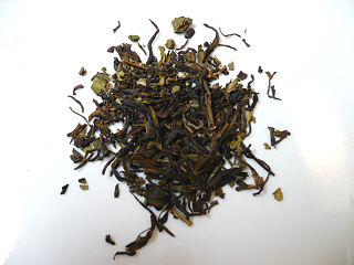
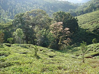
Nilgiri tea is generally described as being a dark, intensely aromatic, fragrant and flavoured tea grown in the southern portion of the Western Ghats mountains of Southern India. It is grown in the hills of the Nilgiris district of Tamil Nadu, though there are numerous other tea-growing districts in South India as well, including Munnar and Central Travancore, further south in Kerala state.

The Nilgiri Mountain Railway (NMR) is a 1,000 mm metre gauge railway in Tamil Nadu, India, built by the British in 1908. The railway is operated by the Southern Railway and is the only rack railway in India.
Many Ghat Roads can be found in the Nilgiris District of Tamil Nadu, Southern India. Nearly all of the district is located in the Nilgiri Hills, part of the Western Ghats mountains. This area borders the states of Karnataka and Kerala. The hills consequently can be reached by road from three states. Most of these Ghat Roads go through heavily forested mountains and contain a number of sharp hair-pin bends.
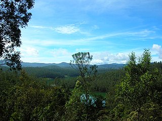
The Nilgiri Mountains form part of the Western Ghats in western Tamil Nadu of Southern India. At least 24 of the Nilgiri Mountains' peaks are above 2,000 metres (6,600 ft), the highest peak being Doddabetta, at 2,637 metres (8,652 ft).
Aravenu is a village in Kotagiri Taluk of The Nilgiris District, Tamil Nadu, India. The population is largely Badaga and it is thought to be an original Badaga Hatti. It is the headquarters of the Jackanarai panchayat.

Burliar is a Panchayat village in Coonoor Taluk of The Nilgiris District, Tamil Nadu, India.

The Nilgiri Express is a night express train service operating between Chennai Central and Mettupalayam, Coimbatore in Tamil Nadu, India. It is operated by Indian Railways.
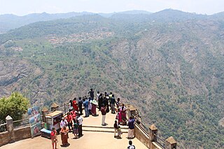
Lamb's Rock is a tourist spot in Coonoor, Tamil Nadu, India, on the slopes of the Nilgiri Hills. It is located at a distance of 8 kilometers from Coonoor. It has a view of the Coimbatore plains, tea estates and coffee estates.
Dolphin's Nose Viewpoint is a tourist spot in Coonoor, The Nilgiris District, Tamil Nadu. Dolphin's Nose is well over 1,550 Meter above sea level, 10 km from Coonoor and is a spectacular spot to visit. The tip of the peak resembles a dolphin's nose, hence the name Dolphin's Nose. It is an enormous rock formation that is entirely unique. There are gigantic ravines found both to the left and right of Dolphin's Nose and there is a view of inspiring Catherine Falls with its continuing stream several thousand metres below which is located a relatively short distance away opposite of the Dolphin's Nose. Best part of spot are the hairpin turns and tea plantations on the way
Law's Falls is a tourist spot in Coonoor, The Nilgiris, Tamil Nadu.
Lady Canning's Seat is major tourist spot in Coonoor, The Nilgiris, Tamil Nadu. It is situated 9 km from the township Coonoor. The site is named after Countess Charlotte Canning.

Katary Falls is approximately 10 km from Coonoor in the Nilgiris district in the state of Tamil Nadu, India. At 55 metres in height, Katary Falls is third largest waterfall in the Nilgiris; one can reach it by trecking.

Rangaswamy Peak and Pillar is a tourist spot in Kotagiri, The Nilgiris, Tamil Nadu. It is located at a distance of 20 km from Kotagiri. Its a very steep peak and not climbed yet. The hill station of Kotagiri has many tourist attractions spot, which include Kodanad View Point, Catherine Falls, Elk falls, Long wood Shola, Mekanad Falls and Rangaswamy Peak and Pillar. The best season to visit is in summer.

Coonoor railway station serves Coonoor, a municipality town and popular hill station in the Nilgiris district of Tamil Nadu. The train station is a part of the Nilgiri Mountain Railway, a World Heritage Site. The train station is an important rail hub for trains passing to Udhagamandalam(Ooty). It is administered by the Salem division of the Southern Railway Zone and the station code is: ONR.
The Pasteur Institute of India produces DPT vaccine and rabies vaccine for the Expanded Program on Immunization in India. It is located in Coonoor, Nilgiris, Tamil Nadu. The institute was initially called the Pasteur Institute of Southern India. In 1907 it changed its name to the Pasteur Institute of India. In 1977 it became an autonomous body under the Ministry of Health and Family Welfare. The institute is named after the French scientist, Louis Pasteur.


