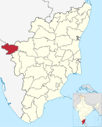
Ooty, abbreviated as Udhagai) is a town and municipality in the Nilgiris district of the Indian state of Tamil Nadu, 86 km (53 mi) north west of Coimbatore, and the headquarters of the Nilgiris district. In the Nilgiri hills, it is known as the "Queen of Hill Stations" and is a popular tourist destination.

The Nilgiris district is one of the 38 districts in the southern Indian state of Tamil Nadu. Nilgiri is the name given to a range of mountains spread across the borders among the states of Tamil Nadu, Karnataka and Kerala. The Nilgiri Hills are part of a larger mountain chain known as the Western Ghats. Their highest point is the mountain of Doddabetta, height 2,637 m. The district is contained mainly within the Nilgiri Mountains range. The administrative headquarters is located at Ooty. The district is bounded by Coimbatore to the south, Erode to the east, and Chamarajnagar district of Karnataka and Wayanad district of Kerala to the north. As it is located at the junction of three states, namely, Tamil Nadu, Kerala, and Karnataka, significant Malayali and Kannadiga populations reside in the district. Nilgiris district is known for natural mines of Gold, which is also seen in the other parts of Nilgiri Biosphere Reserve extended in the neighbouring states of Karnataka and Kerala too.

Doddabetta is the highest mountain in the Nilgiri Mountains at 2,637 metres (8,652 ft). There is a reserved forest area around the peak. It is 9 km from Ooty, on the Ooty-Kotagiri Road in the Nilgiris District of Tamil Nadu, India. It is a popular tourist attraction with road access to the summit. It is the fourth highest peak in South India next to Anamudi, Mannamalai and Meesapulimala. The peaks Hecuba, Kattadadu and Kulkudi are the three closely linked summits in the west of the Doddabetta range near to Udagamandalam. The word Doddabetta is derived from Kannada, meaning 'big hill'.

The Government Botanical Garden is a botanical garden in Udhagamandalam, near Coimbatore (Ooty), Tamil Nadu state, India laid out in 1848. The gardens, divided into several sections, cover an area of around 22 hectares, and lie on the lower slopes of Doddabetta peak. The garden has a terraced layout. It is maintained by the Tamil Nadu Horticulture Department.

Pykara is a river 19 kilometres (12 mi) from Ooty in the Indian State of Tamil Nadu with a village by the same name nearby. The Pykara River is considered very sacred by the Todas. It rises at Mukurthi peak, flows northwards, and then turns to the west after reaching the edge of the plateau. The river flows through Mukurthi, Pykara and Glenmorgan dams, and forms part of an important hydro-electric power project.

Yelagiri is a hill station located in the newly formed Tirupathur district of Tamil Nadu, India, situated off the Vaniyambadi-Tirupattur road. Located at an altitude of 1,110.6 metres above Mean Sea Level and spread across 30 km2, the Yelagiri Hill is surrounded by orchards, rose-gardens, and green valleys. Yelagiri is a branch of Annamalai Hills.
The Entertainment Corridor is a stretch along East Coast Road, Chennai in the Indian state of Tamil Nadu. It runs between Thiruvanmiyur and Mudaliarkuppam and is dotted with a number of theme parks, boat houses, beaches, 5-star hotels and pubs. The corridor is termed "Entertainment Corridor".

Green fields is a suburb in Ooty town in the Tamil Nadu state of India. It constitutes ward no. 9 of the Ooty constituency of Tamil Nadu.

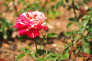
The Government Rose Garden is situated on the slopes of the Elk Hill in Vijayanagaram of Ooty town in Tamil Nadu, India at an altitude of 2200 meters.

Sigur Plateau is a plateau in the north and east of Nilgiri District in the Nilgiri Hills of Tamil Nadu, South India. It covers the 778.8 square kilometres (300.7 sq mi) portion of the Moyar River drainage basin on the northern slopes of the Nilgiri Hills, south of the Moyar River.

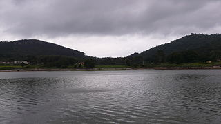
The Kamaraj Sagar Dam is in the Nilgiris district of Tamil Nadu state in India. It is located at a distance of 10 km from the Ooty bus stand. It is a picnic spot and a film shooting spot on the slopes of the Wenlock Downs. The dam's storage capacity is 26.6 million cubic meters(MCM) or 0.94 tmc ft.

Charring cross is a junction in National Highway 67 (India) intersecting the commercial road and the Ooty-Coonoor road in Ooty, Tamil Nadu. It is considered to be one of the most important and beautiful places in Ooty. The important landmark in charring cross is the Gandhi Statue.

Summer Festival is a festival celebrated in the Nilgiri mountains of India each May. The festival is organized by the Tamil Nadu Department of Tourism and the national Ministry of Tourism. Events during the festival include cultural programmes, a Flower Show, a Rose Show, a Dog Show, a Fruit Show, a Spice Show, a Vegetable Show, a Boat Race, and Boat pageantry.

Avalanche Lake is located 28 kilometers from Ooty in the Nilgiris district in Tamil Nadu.
Commercial road is an important roadway passing through foothills in the township of Ooty, Tamil Nadu. The road is characterized by busy pedestrian and road traffic. As the name suggests, the road is an important commercial hub of the town. The most important junction on the road is Charring cross, which is considered to be one of the most important and beautiful places in Ooty. The region adjoining the roadway houses various commercial establishments like Kairali, a Handicrafts Development Corporation of Kerala showroom.

Chetpet lake is a lake spread over 16 acres in Chetput, Chennai, India. It is located to the north of Chetpet railway station. It is the only existing lake at the centre of the city. The lake belongs to the Department of Fisheries of the Tamil Nadu government.

Muttukadu boat house is a water sport facility on the East Coast Road at Muttukadu, Chennai City, Kanchipuram district, Tamil Nadu, India, offering rowing, wind surfing, water skiing, and speedboat riding. It is a backwater area of the Bay of Bengal located 36 km (22 mi) from the city centre and 23 km (14 mi) from Adyar on the way to Mamallapuram. The boat house was inaugurated in 1984 and has 15 row boats, 27 speedboats and 9 pedal boats, besides two high-speed aqua scooters. The water depth varies between 3 ft and 6 ft. It is owned and operated by the Tamil Nadu Tourism Development Corporation (TTDC). The boating spot receives more than 4,000 visitors every weekend.
Mudaliarkuppam Boat House, also known as Raindrop Boat House, is a water sport facility located on the East Coast Road, 36 km to the south of Mamallapuram and 92 km from Chennai in India. It was developed by the Tamil Nadu Tourism Development Corporation on the Odiyur lake back waters. It has rowing, cruising, speed boating, water scooting and kayaking facilities.

Coutrallam Falls is located in Tenkasi district in the South Indian state of Tamil Nadu bordering Kollam district, Kerala. The falls is located on the Western Ghats on the river Chittar and is considered a "medical spa" on account of the medical smell in the waters. It is located 5 km (3.1 mi) from the nearest city Tenkasi. There are a total of nine falls of which Peraruvi, Aintharuvi and Puli Aruvi being the most prominent.


