The Vaigai is a river in the Tamil Nadu state of southern India; it passes through the towns of Theni, Madurai, Manamadurai, Paramakudi and Ramanathapuram.[2] It originates in Varusanadu Hills, the Periyar Plateau of the Western Ghats range, and flows northeast through the Kambam Valley, which lies between the Palani Hills to the north and the Varushanad Hills to the south. The Vattaparai Falls are located on this river. As it rounds the eastern corner of the Varushanad Hills, the river turns southeast, running through the region of Pandya Nadu. Madurai, the largest city in the Pandya Nadu region and its ancient capital, lies on the Vaigai. The river empties into the Palk Bay near Alagankulam, close to Pamban Bridge in Ramanathapuram District.
The Vaigai is 258 kilometres (160mi) long, with a drainage basin7,031 square kilometres (2,715sqmi) large.[3] This river flows through 5 districts namely Theni, Dindigul, Madurai, Sivagangai and Ramanathapuram and serves as a lifeline for 6 districts namely Theni, Dindigul, Madurai, Sivagangai, Virudhunagar and Ramanathapuram as farmers of all these districts are greatly depends on this river water.
During the 20th century, the Vaigai River basin was extensively developed for irrigation, flood control, and the generation of hydroelectric power.
Vaigai in literature
Sangam literature (circa 300 BCE to 300 CE[4][5][6]) has paid many tributes to Vaigai, extolling it as 'the river that brings water when one touches it', viz the etymology Vai (Earth) + yai (sky) = Vaiyai.[7][8]
The following story is told about the birth of the river Vaigai. Koodal Purana details the origin of Vaigai river flowing through Madurai. It is believed that Vishnu stood up as Trivikrama, with one of his feet rising to the skies and the foot reached Brahmaloka, the abode of Brahma. Brahma was pleased to perform ablution to the raised foot and the water is believed to have emerged as a rivulet called Krithimala. As the river came from the sky and fell into Earth it is called Vai which means Vaiyam (Earth) and Yai means coming down hence, the name Vaiyai and later changed into vaigai. It is mentioned as Vaiyai in Paripatal and not Vaigai.[9] A large number of banana trees sprang up in the place and it came to be known as Kadhalivana, a forest of banana trees.[7][8]
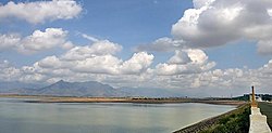
Vaigai River in Madurai, Tamil Nadu
It also is mentioned as the Sanskrit name Kritamala by a Pandya king in the following story. Satyavrata, a ruler of Madurai was a staunch devotee of Vishnu. It is believed that once Vishnu came out of the river Krithimala as a fish (Matsya avatar, one of the avatars of Vishnu) to teach Vedas to the ruler. From then on, the Pandyas started using fish as the symbol of the kingdom.[7][8] In the Sanskrit texts the river also mentioned as Vegavatī,[10] perhaps it is also an etymology to the modern name.
Geography
The Vaigai River watershed It spans roughly 7,000–7,100 square kilometers across five districts of Theni, Dindigul, Madurai, Sivagangai, and Ramanathapuram. Geographically, the basin stretches from the Varushanad Hills of the Western Ghats in the west to the coastal plains by the Bay of Bengal in the east. The basin is about 289–295km long east-to-west and 15–55km wide north-to-south. It is bounded by the Cauvery and Pambar-Kottakaraiyar basins to the north, the Gundar basin to the south, the Periyar basin (in neighboring Kerala) to the west, and it opens into the Palk Strait (part of the Bay of Bengal) on the east.
The topography of the Vaigai watershed can be divided into three distinct regions: a western mountainous terrain with valley complexes, a central upland plateau, and an eastern flat coastal plains. The upper basin in the west lies in the Western Ghats, with elevations reaching up to about 2,600 m in the highest hills. Fertile valleys such as the Cumbum (Kambam) Valley lie between the hills and form important agricultural lowlands in this region. The middle basin around Madurai is relatively flatter, while the lower basin near Ramanathapuram consists of low-lying coastal plains. Major urban centers in the watershed include the historic city of Madurai on the river’s banks, as well as towns like Theni, Dindigul, Uthamapalayam, and Ramanathapuram.
Vaigai gets major feed from the Periyar Dam in Kumili, Kerala. Water from the Periyar River in Kerala is diverted into the Vaigai River in Tamil Nadu via a tunnel through the Western Ghats. In summers, the Vaigai river ends up dry very often. The water scarcely reaches Madurai.[13]
Land Use
The land within the Vaigai River watershed is utilized for a mix of agriculture, forests, settlements, and other uses. Broadly, the basin’s land use can be thought of as one-third agricultural land, one-third forests, and one-third scrub/wasteland, with a small fraction under water bodies or urban areas. Agriculture is a dominant land use, covering roughly 33–38% of the basin in recent decades. This includes irrigated wet croplands (such as rice paddy, sugarcane, and banana plantations) concentrated in valley areas and near tanks, as well as dry croplands (rain-fed fields growing crops like groundnut, millets, maize, cotton, pulses, and vegetables) in the plains. The next major land category is forest. About 30% of the watershed is forested, mainly in the western hilly region. These include medium to dense natural forests, forest plantations, and areas of scrubby forest on hill slopes. Much of this forest lies in the upper catchment (foothills of the Western Ghats and the Palani/Sirumalai hills) and helps protect the soil and store groundwater. A significant portion of the remaining land; on the order of another 30%, is classified as scrub. This includes rocky barren areas, open scrubland with sparse vegetation, and zones affected by soil salinity or alkalinity (particularly in the drier lower basin). There are also many small water bodies dotting the Vaigai basin. Traditional man-made tanks (ponds) and a few reservoirs account for around 2–3% of the areas, providing irrigation storage and groundwater recharge. Lastly, urban and built-up land occupies a relatively small portion (only about 1–2% of the basin).
The Mullaperiyar Dam was built in 1895 by John Pennycuick, who implemented a plan proposed over a century earlier by Pradani Muthirulappa Pillai of Ramnad. The dam was built by the British Army Engineering corps for the Travancore kingdom. The first dam was washed away by floods, and a second masonry dam was constructed in 1895.[16]
References
Wikimedia Commons has media related to Vaigai River.
Tectono-climatic and depositional environmental controls on the Neolithic habitation sites, Vaigai River Basin, Southern India. Geological journal. 8 January 2024. https://doi.org/10.1002/gj.4919
This page is based on this Wikipedia article Text is available under the CC BY-SA 4.0 license; additional terms may apply. Images, videos and audio are available under their respective licenses.