
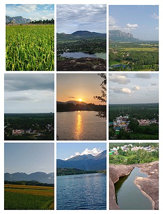
Kanyakumari is a city in Kanyakumari district in the state of Tamil Nadu, India. It is the southernmost tip of the Indian subcontinent and the southernmost city in mainland India, and thus referred to as "The Land's End". The city is situated 90 kilometres (56 mi) south of Thiruvananthapuram city, and about 20 kilometres (12 mi) south of Nagercoil, the headquarters of Kanyakumari district.

Kodaikanal is a municipality and hill station in Dindigul district in the state of Tamil Nadu, India. It is situated at an altitude of 2,225 m (7,300 ft) in the Palani hills of the Western Ghats. Kodaikanal was established in 1845 to serve as a refuge from the high temperatures and tropical diseases during the summer in the plains. It is a popular tourist destination and is referred to as the "Princess of Hill stations" with much of the local economy is based on the hospitality industry serving tourism. As per the 2011 census, the city had a population of 36,501.

The Palani Hills are a mountain range in the southern Indian states of Tamil Nadu and Kerala. The Palani Hills are an eastward extension of the Western Ghats ranges, which run parallel to the west coast of India. The Palani Hills adjoin with the high Anamalai range on the west and extend east into the plains of Tamil Nadu, covering an area of 2,068 square kilometres (798 sq mi). The highest part of the range is in the southwest, and reaches 1,800-2,500 metres elevation; the eastern extension of the range is made up of hills 1,000-1,500 m (3,281-4,921 ft) high.

Kanyakumari district, officially Kanniyakumari district, is one of the 39 districts of Tamil Nadu state and the southern most district in mainland India. It stands second in terms of population density among the districts of Tamil Nadu. It is also the richest district in Tamil Nadu in terms of per capita income, and also tops the state in Human Development Index (HDI), literacy, and education. The district's headquarters is Nagercoil.

Hogenakkal Falls is a waterfall in South India on the Kaveri river on the border between Dharmapuri district of Tamil Nadu and Chamrajnagar district of Karnataka. It is located 46 km (29 mi) from Dharmapuri and 199 km (124 mi) from Chamrajnagar. Carbonatite rocks in this site are considered to be the oldest of its kind in South Asia and one of the oldest in the world. The Government of Tamil Nadu made a proposal to convert the falls into providing drinking water for the state.

Thalaiyar Falls"prohibited Water falls by Theni forest division", also known as Rat Tail Falls is a waterfall Located in the Theni District, which flows as Manjalar River, one of the tributaries of Vaigai river which flows in the south of Tamil Nadu State, South India. It is 297 m (974 ft) tall and is the highest waterfall in Tamil Nadu, the Sixth highest waterfall in India and the 267th highest in the world.
Azhagiapandiapuram is a second grade town panchayat in Kanniyakumari district in the state of Tamil Nadu, India. It is located at the centre of Pazhayar valley. It is one of the four town panchayat's in Thovalai taluk.
Vellarimala Hills is a mountain range in Kerala, India, spread across Thiruvambady Panchayat in Kozhikode district and Meppadi Panchayat in Wayanad district.
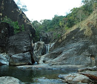
Vattaparai Falls are located at: 8°15.919′N77°27.062′E, elevation 40 m (130 ft), in the Keeriparai reserve forest near Bhoothapandi village (Pin:629852) on the Pazhayar River in Kanyakumari district, Tamil Nadu state, South India. It is 25 km (16 mi) N of Nagercoil) and 32 km (20 mi) NW of Kanyakumari. This 20 km2 (7.7 sq mi) area is proposed to be a Wildlife Sanctuary.
Thirparappu Waterfalls is located near Kulasekharam town in Kanyakumari district, Tamil Nadu state, India.

Aryankavu is a village located in the Kollam district of the Indian state of Kerala. It lies close to the border between Kerala and Tamil Nadu near Thenmala. It is also one of the famous pilgrimage sites associated with the legend of Sabarimala. The village is located beside Shendurney Wildlife Sanctuary.

Vadakku valliyur or Valliyur is a Special Grade Town Panchayat in Radhapuram taluk in Tirunelveli district in the Indian state of Tamil Nadu.Valliyur is one of the fastest-growing towns in Tirunelveli district. This town is located along NH 7. It gets its name from the goddess Valli, consort of Lord Murugan. The place connects the big city of Tirunelveli to the city of Nagercoil and town of Kanyakumari on NH 7.
Talakona is situated in Tirupati district of Andhra Pradesh, India. It is a resort with waterfalls, dense forests and wildlife. Talakona waterfall is in Sri Venkateswara National Park, Tirupati district of Andhra Pradesh. With a 270 feet (82 m)-fall, Talakona is the highest waterfall in Andhra Pradesh state. Talakona is also known for the Lord Siddheswara Swamy Temple, which is located close to the waterfall.

Monkey Falls are natural waterfalls located near the uphill ghat road Valparai on the Pollachi-Valparai road in the Anaimalai Hills range, in Coimbatore district.

The Pothigai Hills, also known as Agasthiyar Mountain is a 1,866-metre (6,122 ft)-tall peak in the southern part of the Western Ghats or Sahyadri of South India. The peak lies in Tirunelveli District of Tamil Nadu near the border of Kerala.

Sirumalai is a massive region of 60,000 acres (200 km2) situated 25 km (16 mi) from Dindigul, 90 km (56 mi) from Madurai, and 125 km from Trichy, Tamil Nadu, India. There are many high hills in the area. Sirumalai range is the last mountain range of the Eastern Ghats. The last mountains of the Sirumalai mountain range are the Azhagar Kovil Hills which are present in Madurai District. Azhagar Kovil Hills are the most important place of worship for the Hindu religion. Trekking is allowed in the Azhagar Kovil Hills. The nearest Eastern Ghats hills to Sirumalai Hills are the Narthamalai Hills.
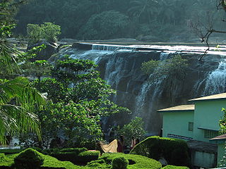
Thirparappu is a town located in the Kanyakumari District in the Indian state of Tamil Nadu. It is a popular tourist destination. It is located 5.9 km (3.7 mi) from the nearby town Arumanai, 6.9 km (4.3 mi) from Kulasekaram, 42 km (26 mi) from Nagercoil, headquarters of the Kanyakumari District, and 55 km (34 mi) from Thiruvananthapuram, the capital of the Indian state of Kerala. It is famous for its falls on the Kodayar (Kothai) River and the Pechiparai Dam, located 13 km (8.1 mi) away.
S. S. Davidson is one of the pioneer educators of the environmental movement in Tamil Nadu, India. Davidson was born at Nagercoil in Kanyakumari District, India. He earned a degree in English from Scott Christian College, after which he joined as faculty in English. He completed his Master's Degree and Master of Philosophy in English from Annamalai University

Coutrallam Falls is located in Tenkasi district in the South Indian state of Tamil Nadu bordering Kollam district, Kerala. The falls is located on the Western Ghats on the river Chittar and is considered a "medical spa" on account of the medical smell in the waters. It is located 5 km (3.1 mi) from the nearest city Tenkasi. There are a total of nine falls of which Peraruvi, Aintharuvi and Puli Aruvi being the most prominent.
Aloor is a panchayat town in Kanyakumari district in the state of Tamil Nadu, India. It is about 8 km from Nagercoil, the Headquarters of Kanyakumari District. In the Tamil Nadu State Legislative Assembly, it belongs to Colachel constituency.
