The river begins in the dense forest on a mountain peak 1,300 metres (4,300ft) above sea level in Ex-Singampatti Zamindari, Ambasamudram taluk and flows 9 kilometres (6mi) though small cataracts until it reaches the Tambaraparani River near Kallidaikurichi.
The tributaries of the Manimuthar are the Keezha River and the Varattar River. As a tributary, the Manimuther River adds a considerable amount of water to the Tamiraparani River as it seasonally is always in full.
In 1957, Manimuthar anicut was built across the river 3 kilometres (2mi) before its juncture with the Tamiraparani.[1]
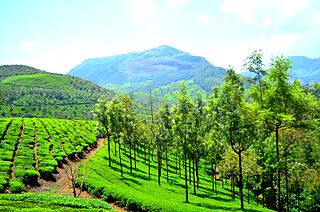
Located between elevations ranging from 1,000 to 1,500 metres (3,300 to 4,900ft), the Manjolai area is set deep within the Western Ghats within the Kalakad Mundanthurai Tiger Reserve in the Tirunelveli District. Located on top of the Manimuthar Dam and the Manimuthar Water Falls, the Manjolai area comprises tea plantations, small settlements around the tea plantations, Upper Kodaiyar Dam and a windy viewpoint called Kuthiravetti.[citation needed]
The tea plantations and the whole of Manjolai Estates are tea operated by The Bombay Burmah Trading Corporation Ltd on forest lands leased by Raja of Singampatti Samasthanam. There are three Tea Estates within the Manjolai area – Manjolai Estate, Manimutharu Estate and Oothu Estate. The Estates are located on elevations ranging between 700 and 1,280 metres (2,300 and 4,200ft).[citation needed]
The estates, road and settlements in the Manjolai area are managed by The Bombay Burmah Trading Corporation Ltd. Only the workers of Bombay Burmah Trading Corporation Ltd and employees of TNEB can enter the zone without any permission. Tourists must get prior permission from Amabasamudram Range Office (KMTR) before entering into the forest range. Only four wheelers are allowed. A special tourist vehicle is also arranged by KMTR to visit the tea plantations. Prior intimation and fees must be paid in order to enter into the forest zone.[citation needed]
Munnar is a town and hill station located in the Idukki district of the southwestern Indian state of Kerala. Munnar is situated at around 1,600 metres (5,200 ft) above mean sea level, in the Western Ghats mountain range. Munnar is also called the "Kashmir of South India" and is a popular honeymoon destination.
Kallidaikurichi or Kalladaikurichi is a town on the right bank of the Thamiraparani river in Ambasamudram Taluk of Tirunelveli district in Tamil Nadu, a southern state of India.
Thekkady(Idukki district) is a town near Periyar National Park, an important tourist attraction in the Kerala state of India. The name Thekkady is derived from the word "thekku" which means teak. Temperatures are lowest in the months of December–January and highest in the months of April–May.
Periyar, IPA:[peɾijɐːr], is the longest river and the river with the largest discharge potential in the Indian state of Kerala. It is one of the few perennial rivers in the region and provides drinking water for several major towns. The Periyar is of utmost significance to the economy of Kerala. It generates a significant proportion of Kerala's electrical power via the Idukki Dam and flows along a region of industrial and commercial activity. The river also provides water for irrigation and domestic use throughout its course besides supporting a rich fishery. Due to these reasons, the river has been named the "Lifeline of Kerala". Kochi city, in the vicinity of the river mouth draws its water supply from Aluva, an upstream site sufficiently free of seawater intrusion. Twenty five percent of Kerala's industries are along the banks of river Periyar. These are mostly crowded within a stretch of 5 kilometres (3 mi) in the Eloor-Edayar region (Udhyogamandal), about 10 kilometres (6 mi) north of Kochi harbor.
The Anamala or Anaimalai, also known as the Elephant Mountains, are a range of mountains in the southern Western Ghats of central Kerala and span the border of western Tamil Nadu in Southern India. The name anamala is derived from the Malayalam word aana and the Tamil word yaanai, meaning elephant, or from tribal languages. Mala or Malai means 'mountain', and thus literally translatable as 'Elephant mountain'.
Anaimalai Tiger Reserve, earlier known as Indira Gandhi Wildlife Sanctuary and National Park and as Anaimalai Wildlife Sanctuary, is a protected area in the Anaimalai Hills of Pollachi and Valparai taluks of Coimbatore District and Udumalaipettai taluk in Tiruppur District, Tamil Nadu, India. The Tamil Nadu Environment and Forests Department by a notification dated 27 June 2007, declared an extent of 958.59 km2 that encompassed the erstwhile IGWLS&NP or Anaimalai Wildlife Sanctuary, as Anaimalai Tiger Reserve under the Wildlife Protection Act, 1972. According to the National Tiger Conservation Authority, the Reserve presently includes a core area of 958.59 km2 and buffer/peripheral area of 521.28 km2 forming a total area of 1479.87 km2.
The Thamirabarani or Tamraparni or Porunai is a perennial river that originates from the Agastyarkoodam peak of Pothigai hills of the Western Ghats, above Papanasam in the Ambasamudram taluk. It flows through Tirunelveli and Thoothukudi districts of the Tamil Nadu state of southern India into the Gulf of Mannar. It was called the Tamraparni River in the pre-classical period, a name it lent to the island of Sri Lanka. The old Tamil name of the river is Porunai. From the source to sea, the river is about 128 kilometres (80 mi) long and is the only perennial river in Tamil Nadu. This river flows towards north direction initially. However, it changes to east direction later.
Tirunelveli district is one of the 38 districts of Tamil Nadu state in India. It is the largest district in terms of area with Tirunelveli as its headquarters. The district was formed on 1 September 1790 by the British East India Company, and comprised the present Tirunelveli and Thoothukudi, Tenkasi and parts of Virudhunagar and Ramanathapuram district. As of 2011, the undivided district had a population of 3,077,233.
Ambasamudram is the principal town of the Ambasamudram taluk in Tirunelveli district in the state of Tamil Nadu, India. The entire taluk had a population of 392,226 as of 2001, with 42.5% classified as rural. The town of Ambasamudram had a population 35,645 as of 2011.
Kalakad is a Municipality in Tirunelveli district in the Indian state of Tamil Nadu. Kalakad is one of the 3 Municipalities of Tirunelveli District, and is one of the fastest-growing towns in the district.
Manimutharu is a panchayat town in Tirunelveli district in the Indian state of Tamil Nadu.
Vickramasingapuram or V.K.Puram is a Municipal town in Tirunelveli District in the Indian state of Tamil Nadu. It falls under the Ambasamudram Taluk. As of 2011, the town had a population of 47,241.
The Bombay Burmah Trading Corporation Limited (BBTC) is an Indian trading company based in Mumbai owned by the Wadia Group. It was formed in 1863 by the Wallace Brothers of Scotland. It is India's oldest publicly traded company, and was established to engage in the Burmese tea business through the initial step of taking over the Burmese assets of William Wallace.
Meghamalai, commonly known as the High Wavy Mountains, is a mountain range located in the Western Ghats in the Theni district near Kumily, Tamil Nadu. It is dotted with cardamom plantations and tea plantations. The mountain range is 1,500 metres above sea level, and it is rich in flora and fauna. The area, now mostly planted with tea plants, includes cloudlands, high wavys, venniar, and the manalar estates belonging to the Woodbriar Group. Access is largely restricted and includes largely untouched remnants of evergreen forest.
Kalakkad Mundanthurai Tiger Reserve (KMTR) located in the South Western Ghats montane rain forests in Tirunelveli district and Kanyakumari district in the South Indian state of Tamil Nadu, is the second-largest protected area in Tamil Nadu. It is part of the Agasthyamala Biosphere Reserve.
Agastyaarkoodam is one of the peaks in the Western Ghats of Tirunelveli District of Tamil Nadu, near to the border of Kerala, India. This peak is a part of the Agasthyamala Biosphere Reserve which lies on the border between the Indian states of Tamil Nadu, Tirunelveli district and Kerala, Thiruvananthapuram district. The perennial Thamirabarani River originates from the eastern side of the range and flows into the Tirunelveli district of Tamil Nadu. It is 1,868-metres tall.
The Pothigai Hills, also known as Agasthiyar Mountain is a 1,866-metre (6,122 ft)-tall peak in the southern part of the Western Ghats of South India. The peak lies in Tirunelveli District of Tamil Nadu near the border of Kerala.
Papanasam also spelt as Pavanasam is a famous picnic spot in Tirunelveli district in the Indian state of Tamil Nadu. It falls under the Ambasamudram Taluk. It is situated 60 kilometres (37 mi) from Tirunelveli. The site features tourist attractions like Thamirabarani River, Agasthiyar Falls, Siva Temple, and Papanasam dam and hydroelectric power plant.
Rangit Dam, which forms the headworks of the Rangit Hydroelectric Power Project Stage III, is a run-of-the-river hydroelectric power project on the Ranjit River, a major tributary of the Teesta River in the South Sikkim district of the Northeastern Indian state of Sikkim. The project's construction was completed in 1999. The project is fully functional since 2000. The project was built at a cost of Rs 4922.6 million. The average annual power generation from the 60 MW project is 340 GWh with firm power of 39 MW.
Singampatti. This palaiyam headed 24 of 72 palaiyams was located in present day Ambasamudram taluk, two miles from the spurs of the Western Ghats, in Tirunelveli district.
This page is based on this Wikipedia article Text is available under the CC BY-SA 4.0 license; additional terms may apply. Images, videos and audio are available under their respective licenses.