This article has multiple issues. Please help improve it or discuss these issues on the talk page . (Learn how and when to remove these messages)
|
Malenadu Malnad | |
|---|---|
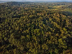 Forests of Malenadu | |
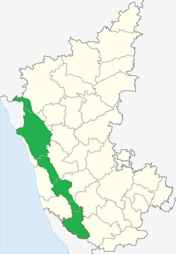 Malenadu region shown in green | |
| Country | |
| State | |
| Region | Malenadu |
| Tehsil | Belagavi District Khanapur Uttara Kannada Sirsi Joida Dandeli Haliyal Yellapur Mundgod Siddapur Shivamogga District Sagara Hosanagara Soraba Shikaripura Bhadravati ThirthahalliChikkamagaluru District Sringeri Kalasa Koppa Narasimharajapura Mudigere Hassan District Sakleshpur Arkalgud Belur Kodagu District Somwarpet Madikeri Virajpet Kushalanagar Ponnampet Dakshina Kannada Sullia |
| Languages | |
| • Official | Kannada |
| • Regional | Havyaka Kannada Kodava Tulu Konkani Arebhashe |
| Time zone | UTC+5:30 (IST) |
Malnad (or Malenadu) is a region in the state of Karnataka, India. Malenadu covers the western and eastern slopes of the Western Ghats mountain range and is roughly 100 kilometers in width. It includes the districts of Uttara Kannada, Chikkamagaluru, Udupi, Belagavi, Dakshina Kannada, Hassan, Kodagu, Shivamogga. The region experiences heavy annual rainfall of 1,000–3,800 millimetres (39–150 inches); it includes the village of Agumbe, which receives the highest annual rainfall in Karnataka (over 10,000 mm).
Contents
This region of the state experiences unique development problems due to settlement patterns, sparse population, topography, dense forest, and numerous rivulets. Villages in the Malnad are scattered throughout remote areas. To encourage development in the area, the l Area Development Board was created to implement necessary projects. The districts covered initially in this region were Shivamogga, Chikkamagaluru, Uttara Kannada, Kodagu, and Hassan. Presently, the Development Board operates in part or all of 13 districts of the state, and comprises 65 Assembly constituencies and 61 taluks:
| District | Constituencies |
|---|---|
| Belgaum | Bailahongal, Belgaum, Hukkeri, Khanapur, Saudi |
| Chamarajnagar | Chamarajnagar, Gundlupete, Kollegala, Hanuru |
| Chikkamagalur | Kadur, Koppa, Chikkamagalur, Mudigere, Narasimharajapur, Shringeri, Tarikere, Ajjampura |
| Dakshina Kannada | Mangalore, Puttur, Sulya, Bantwal, Belthangadi, Mudubidri, Kadaba |
| Davanagere | Channagiri, Honnali, Nyamathi |
| Dharwad | Kalaghatagi, Alnanavara |
| Hassan | Alur, Arakalagud, Belur, Sakaleshpur |
| Haveri | Hangal, Hirekerur, Rettihalli, Byadagi, Savanur, Shiggaon |
| Kodagu | Madikeri, Somavarpet, Virajpet |
| Mysore | Heggadadevana kote, Hunasur, Periyapattana, Sargur |
| Shivamogga | Bhadravati, Shivamogga, Sagar, Soraba, Hosanagara, Thirthahalli, Shikaripura |
| Udupi | Udupi, Kundapur, Karkala, Brahmavara, Kapu, Byndoor, Hebri |
| Uttara Kannada | Ankola, Bhatkal, Haliyal, Honnavara, Karwar, Kumta, Mundagod, Siddapur, Sirsi, Joida, Yallapur, Dandeli |