WikiMili
List of peaks in the Western Ghats
Last updated
August 28, 2025
The following is a
list of peaks in the Western Ghats
:
Rank
Name
Elevation
Location
State
Coordinates
Image
1
Anamudi
2,695
m (8,842
ft)
Eravikulam National Park
Kerala
10°10′09″N
77°03′38″E
/
10.16917°N 77.06056°E
/
10.16917; 77.06056
2
Meesapulimala
2,640
m (8,660
ft)
Idukki
Kerala
10°05′51″N
77°12′12″E
/
10.097403°N 77.203417°E
/
10.097403; 77.203417
3
Doddabetta
2,637
m (8,652
ft)
Nilgiris
Tamil Nadu
11°22′17″N
76°31′03″E
/
11.37139°N 76.51750°E
/
11.37139; 76.51750
4
Kolaribetta
2,629
m (8,625
ft)
Mukurthi National Park
Tamil Nadu
11°17′28″N
76°33′00″E
/
11.291°N 76.550°E
/
11.291; 76.550
5
Mukurthi Peak
2,594
m (8,510
ft)
Nilgiris-Nilambur
Tamil Nadu
-
Kerala
11°22′17″N
76°31′03″E
/
11.3713°N 76.5175°E
/
11.3713; 76.5175
6
Vandaravu
2,553
m (8,376
ft)
Palani Hills
Tamil Nadu
10°08′56″N
77°16′23″E
/
10.149°N 77.273°E
/
10.149; 77.273
7
Kattumala
[
1
]
2,552
m (8,373
ft)
Eravikulam National Park
Kerala
10°15′16.5702″N
77°05′52.2843″E
/
10.254602833°N 77.097856750°E
/
10.254602833; 77.097856750
8
Snowdon
2,530
m (8,300
ft)
Nilgiris
Tamil Nadu
9
Devimala
2,523
m (8,278
ft)
Devikulam
Kerala
10
Kumarikkal Mala
2,522
m (8,274
ft)
Chinnar Wildlife Sanctuary
Kerala
11
Elk Hill
2,466
m (8,091
ft)
Nilgiris
Tamil Nadu
12
Club Hill
2,448
m (8,031
ft)
Nilgiris
Tamil Nadu
13
Kulkudi
2,439
m (8,002
ft)
Nilgiris
Tamil Nadu
14
Kattadadu
2,418
m (7,933
ft)
Nilgiris
Tamil Nadu
15
Perumal Malai
2,234
m (7,329
ft)
Kodaikanal
Tamil Nadu
10°17′56.103″N
77°33′51.05″E
/
10.29891750°N 77.5641806°E
/
10.29891750; 77.5641806
16
Eravimala
2,401
m (7,877
ft)
Idukki
Kerala
17
Anginda peak
2,383
m (7,818
ft)
Nilgiris
Tamil Nadu
11°12′26″N
76°27′51″E
/
11.20722°N 76.46417°E
/
11.20722; 76.46417
18
Hecuba
2,375
m (7,792
ft)
Nilgiris
Tamil Nadu
19
Nandala Mala
2,372
m (7,782
ft)
Chinnar Wildlife Sanctuary
Kerala
20
Vavul Mala
[
2
]
2,339
m (7,674
ft)
Malappuram
Nilambur
,
Kozhikode
Kerala
11°25′41″N
76°07′52″E
/
11.42806°N 76.13111°E
/
11.42806; 76.13111
21
Sispara
2,206
m (7,238
ft)
Silent Valley National Park
Kerala
11°12′12″N
76°25′56″E
/
11.20333°N 76.43222°E
/
11.20333; 76.43222
22
Kottakombu Mala
2,144
m (7,034
ft)
Chinnar Wildlife Sanctuary
Kerala
23
Chembra Peak
2,100
m (6,900
ft)
Wayanad
Kerala
11°30′44″N
76°05′22″E
/
11.51222°N 76.08944°E
/
11.51222; 76.08944
24
Elivai Mala
[
3
]
2,088
m (6,850
ft)
Palakkad
Kerala
10°56′23.974″N
76°37′56.96″E
/
10.93999278°N 76.6324889°E
/
10.93999278; 76.6324889
25
Banasura Hill
2,073
m (6,801
ft)
Wayanad
Kerala
11°41′39″N
75°54′29″E
/
11.69417°N 75.90806°E
/
11.69417; 75.90806
26
Kottamala
2,019
m (6,624
ft)
Periyar National Park
Tamil Nadu
9°31′16″N
77°24′07″E
/
9.52111°N 77.40194°E
/
9.52111; 77.40194
27
Mullayanagiri
1,930
m (6,330
ft)
Chikmagalur
Karnataka
13°23′27.5″N
75°43′17″E
/
13.390972°N 75.72139°E
/
13.390972; 75.72139
28
Devar Mala
1,960
m (6,430
ft)
Pathanamthitta
Kerala
29
Baba Budangiri
1,895
m (6,217
ft)
Chikmagalur
Karnataka
13°25′16″N
75°45′47″E
/
13.421°N 75.763°E
/
13.421; 75.763
30
Kudremukha
1,894
m (6,214
ft)
Chikmagalur
Karnataka
13°07′46.24″N
75°16′06.79″E
/
13.1295111°N 75.2685528°E
/
13.1295111; 75.2685528
31
Agasthyamala
1,868
m (6,129
ft)
Thiruvananthapuram
Tirunelveli
border
Kerala
Tamil Nadu
border
8°37′N
77°15′E
/
8.617°N 77.250°E
/
8.617; 77.250
32
Kemmangundi peak
1,863
m (6,112
ft)
Chikmagalur
Karnataka
13°30′58″N
75°46′26″E
/
13.516°N 75.774°E
/
13.516; 75.774
33
Biligiriranga Hills
1,816
m (5,958
ft)
Chamarajanagar
Karnataka
11°51′58″N
77°11′17″E
/
11.866°N 77.188°E
/
11.866; 77.188
34
Rangaswamy Peak and Pillar
1,794
m (5,886
ft)
Nilgiris
Tamil Nadu
35
Velliangiri Mountains
[
4
]
1,778
m (5,833
ft)
Coimbatore
Tamil Nadu
10°59′19.68″N
76°41′14.279″E
/
10.9888000°N 76.68729972°E
/
10.9888000; 76.68729972
36
Tadiandamol
1,748
m (5,735
ft)
Kodagu
Karnataka
12°13′3.2308″N
75°36′31.7340″E
/
12.217564111°N 75.608815000°E
/
12.217564111; 75.608815000
37
Kumara Parvata
1,712
m (5,617
ft)
Pushpagiri Wildlife Sanctuary
Karnataka
12°40′00″N
75°41′00″E
/
12.66667°N 75.68333°E
/
12.66667; 75.68333
38
Merthi Gudda
1,676
m (5,499
ft)
Chickmagalur
Karnataka
39
Malleswaran
1,664
m (5,459
ft)
Agali Hills
Kerala
40
Kalsubai
1,648
m (5,407
ft)
Ahmednagar
Maharashtra
19°36′04″N
73°42′33″E
/
19.60111°N 73.70917°E
/
19.60111; 73.70917
41
Mahendragiri
1,645
m (5,397
ft)
Tirunelveli
Tamil Nadu
8°23′18″N
77°31′17″E
/
8.38833°N 77.52139°E
/
8.38833; 77.52139
42
Kote betta
1,620
m (5,310
ft)
Kodagu
Karnataka
43
Brahmagiri
1,608
m (5,276
ft)
Kodagu
/
Wayanad district
Karnataka
/
Kerala
11°57′N
75°57′E
/
11.950°N 75.950°E
/
11.950; 75.950
44
Padagiri
1,585
m (5,200
ft)
Nelliampathy
Kerala
10°28′46″N
76°42′5″E
/
10.47944°N 76.70139°E
/
10.47944; 76.70139
45
Salher
1,567
m (5,141
ft)
Nashik
Maharashtra
20°43′20.137″N
73°56′43.64″E
/
20.72226028°N 73.9454556°E
/
20.72226028; 73.9454556
46
Madikeri
1,525
m (5,003
ft)
Kodagu
Karnataka
12°25′15.24″N
75°44′22.919″E
/
12.4209000°N 75.73969972°E
/
12.4209000; 75.73969972
47
Pulamala
1,505
m (4,938
ft)
Thekkady
Kerala
48
Dhodap
1,472
m (4,829
ft)
Nashik
Maharashtra
49
Gangamoola
1,458
m (4,783
ft)
Kudremukh National Park
Karnataka
50
Himavad Gopalaswamy Betta
1,450
m (4,760
ft)
Bandipur National Park
Karnataka
51
Karimala Gopuram
1,438
m (4,718
ft)
Parambikulam Wildlife Sanctuary
Kerala
52
Taramati
1,431
m (4,695
ft)
Ahmednagar
Maharashtra
53
Torna
1,405
m (4,610
ft)
Pune
Maharashtra
54
Purandar
1,387
m (4,551
ft)
Pune
Maharashtra
55
Paithalmala
1,372
m (4,501
ft)
Kannur
Kerala
56
Kodachadri
1,343
m (4,406
ft)
Shimoga
Karnataka
57
Rajgad
1,318
m (4,324
ft)
Pune
Maharashtra
58
Sinhagad
1,312
m (4,304
ft)
Pune
Maharashtra
59
Ratangad
1,297
m (4,255
ft)
Ahmednagar
Maharashtra
60
Brahmagiri Hill
1,295
m (4,249
ft)
Trimbakeshwar
Maharashtra
61
Anjaneri
1,284
m (4,213
ft)
Nasik
Maharashtra
62
Saptashrungi
1,264
m (4,147
ft)
Nasik
Maharashtra
63
Meenuliyan Para
1,220
m (4,000
ft)
Idukki
Kerala
64
Sonsogor
1,166
m (3,825
ft)
Sattari
Goa
65
Vagamon
1,100
m (3,600
ft)
Vagamon
Kerala
66
Varayadumotta
1,100
m (3,600
ft)
Ponmudi
Kerala
67
Pratapgad
1,080
m (3,540
ft)
Satara
Maharashtra
68
Ettina Bhuja
1,050
m (3,440
ft)
Chikkamagaluru
Karnataka
69
Illikkal Kallu
1,036
m (3,399
ft)
Kottayam
Kerala
70
Ranipuram
1,016
m (3,333
ft)
Kasarkod
Kerala
71
Don
1,000
m (3,300
ft)
Dang
Gujarat
72
Saputara
990
m (3,250
ft)
Dang
Gujarat
73
Nedumpara Peak
900
m (3,000
ft)
Kollam
Kerala
74
Wilson Hills
890
m (2,920
ft)
Dharampur
Gujarat
75
Mahuli
858
m (2,815
ft)
Thane
Maharashtra
76
Marunthuvazh Malai
830
m (2,720
ft)
Kanyakumari
Tamil Nadu
77
Raigad
820
m (2,690
ft)
Raigad
Maharashtra
78
Mangattu Kumban
635
m (2,083
ft)
Thrissur
Kerala
79
Vagheri Hills
560
m (1,840
ft)
Mhadei Wildlife Sanctuary
Goa
80
Kodikuthi Mala
522
m (1,713
ft)
Malappuram
Kerala
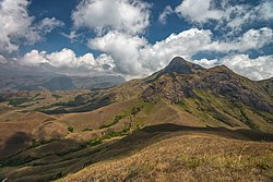
Gallery
Nilgiris
, a part of Western Ghats at Masinangudi,
Tamil Nadu
Kodachadri
Hills
Banasura Hill
with cloud covered
Malleswaran
in a distant vision
Varayadumotta
with 13 peaks
References
↑
"Eravikulam National Park, Munnar, Kerala, India, the home of Nilgiri Tahr"
.
Eravikulam.org
. Archived from
the original
on 4 April 2010
. Retrieved
12 May
2016
.
↑
"Vavul Mala"
.
Peakbagger.com
. Retrieved
12 May
2016
.
↑
"Elivai Malai"
. Retrieved
12 May
2016
.
↑
"Vellayiangiri Mountain"
. Retrieved
12 May
2016
.
v
t
e
Western Ghats
States
Goa
Gujarat
Karnataka
Kerala
Maharashtra
Tamil Nadu
Regions
Desh
Kongu Nadu
Konkan
Malabar
Malenadu
North Malabar
Tulu Nadu
Peaks
Agasthyamalai
Ambukuthi
Anamudi
Anginda
Anjaneri
Baba Budangiri
Banasura
Brahmagiri
Chembra
Devar Mala
Devimala
Dhodap
Doddabetta
Don
Elivai Malai
Eravimala
Ettina Bhuja
Gangamoola
Gopalaswamy Betta
Illikkal Kallu
Kalsubai
Karimala Gopuram
Kattumala
Kemmangudi
Kodachadri
Kodikuthi Mala
Kolaribetta
Kottamala
Kudremukh
Kumara Parvata
Kumarikkal Mala
Kurumbalakotta
Madikeri
Mahendragiri
Mahuli
Malleswaran
Marunthuvazh Malai
Meenuliyan Para
Meesapulimala
Mukurthi
Mullayanagiri
Nedumpara
Padagiri
Paithalmala
Perumal Malai
Pratapgad
Purandar
Raigad
Rajgad
Rangaswamy
Ranipuram
Ratangad
Salher
Saptashrungi
Saputara
Sinhagad
Sispara
Sonsogor
Tadiandamol
Taramati
Torna
Vagamon
Vandaravu
Varayadumotta
Vavul Mala
Velliangiri
Hills
Ambanad
Anaimalai
Biligiriranga
Cardamom
Nilgiri
Satmala
Selbari
Palani
Thirumoorthy
Trimbakeshwar
Rivers
Achankovil
Adan
Amarja
Ambankadavu
Anjarakandi River
Arkavathi
Ayalurpuzha
Banganga
Bhadra
Bharathappuzha
Bhavani
Bhima
Bindusara
Chakra
Chalakudy
Chaliyar
Cherukunnapuzha
Cherupuzha
Cheruthoni
Chitravathi
Chittar
Chulki Nala
Chulliyar
Dahisar
Daman Ganga
Dandavati
Darna
Edamalayar
Gangavalli
Gayathripuzha
Ghataprabha
Girna
Godavari
Gomai
Gomukhi
Gurupura
Hemavati
Honnuhole
Indravati
Indrayani
Iruvanjippuzha
Ithikkara
Kabini
Kadalundi
Kadva
Kali
Kallada
Kallayi
Kalpathipuzha
Kanjirappuzha
Kannadipuzha
Karamana
Karanja
Karha
Karimpuzha
Kaveri
Kedaka
Kodaganar
Kodavanar
Kokkiliyar
Kolar
Korapuzha
Korayar
Kottappuzha
Koyna
Krishna
Kubja
Kumaradhara
Kumudvathi
Kundali
Kundalika
Kunthipuzha
Kurumali
Kuthirappuzha
Lakshmana Tirtha
Madatharuvi
Mahé
Malampuzha
Malaprabha
Mangalam
Manimala
Manimuthar
Manjalar
Manjira
Markandeya
Maruthappuzha
Meenachil
Meenkarappuzha
Mithi
Moyar
Mula
Mula-Mutha
Mullayar
Mutha
Muthirapuzha
Muvattupuzha
Nanganjiyar
Narmada
Neerppuzha
Netravati
Neyyar
Nira
Noyyal
Oshiwara
Pachaiyar
Pahrali
Painganga
Palar
Palar (Kaveri)
Pallichelaru
Pamba
Pambar
Pambar
Panchagangavalli
Panchganga
Pandippuzha
Panzara
Papagni
Papanasini
Parambikulam
Patalganga
Pavana
Payaswini
Penna
Perinjankutti
Periyar
Poisar
Ponnaiyar
Pranahita
Punnappuzha
Purna (Godavari)
Purna (Tapti)
Dnyanganga
Savitri
Shahanur
Shambhavi
Sharavati
Shimsha
Shivana
Sindphana
Souparnika
Tansa
Tapti
Tasso
Thamirabarani
Thuppanadippuzha
Thuthapuzha
Tirur
Tunga
Tungabhadra
Ulhas
Vaan
Vaippar
Valapattanam
Vandazhippuzha
Varada
Varahi
Vashishti
Vedavathi
Venna
Vrishabhavathi
Wainganga
Wardha
Waterfalls
Abbey
Aruvikkuzhy
Athirappilly
Ayyanar
Bandaje
Barkana
Catherine
Charpa
Chunchanakatte
Courtallam
Devaragundi
Devkund
Dudhsagar
Godchinamalaki
Gokak
Hanumangundi
Hebbe
Hogenakkal
Irupu
Jaladurga
Jog
Kalhatti (Nilgiris)
Kalhatti
Katary
Kumbakkarai
Kumbhavurutty
Kuchikal
Kune
Kutladampatti
Law's
Magod
Mallalli
Manalar
Meenmutty
Monkey
Muthyala Maduvu
Oliyarik
Palaruvi
Pandavgad
Pattathippara
Perunthenaruvi
Sahasrakund
Sathodi
Sengupathi
Shivanasamudra
Shivganga
Siruvani
Soochipara
Suruli
Thalaiyar
Thusharagiri
Tirparappu
Ulakkai
Unchalli
Vaideki
Vajrapoha
Vattaparai
Vazhachal
Lakes
Avalanche
Berijam
Kodaikanal
Ooty
Pykara
Sasthamkotta
Vellayani
Protected areas
and reserves
Anamalai
Annekal
Aralam
Agasthyamala
Agasthyavanam
Bandipur
Bannerghatta
Bhadra
Bhimgad
Brahmagiri
Chandoli
Chimmony
Chinnar
Dandeli
Eravikulam
Grass Hills
Grizzled Squirrel
Kali
Kalakkad-Mundanthurai
Karian Shola
Karnala
Kodaikanal
Koyna
Kudremukh
Mhadei
Mudumalai
Mukurthi
Nagarhole
New Amarambalam
Neyyar
Nilgiri
Palani
Parambikulam
Peechi-Vazhani
Peppara
Periyar
Pushpagiri
Radhanagari
SAI
Sathyamangalam
Shendurney
Silent Valley
Someshwara
Talakaveri
Thanthai
Wayanad
Ghats and gaps
Amba Ghat
Amboli Ghat
Bhor Ghat
Chorla Ghat
Goa Gap
Kumbharli Ghat
Naneghat
Palakkad Gap
Tamhini Ghat
Thal Ghat
Varandha Ghat
Dams and
reservoirs
Aathupalayam
Aliyar
Almatti
Amaravathi
Basava Sagara
Bhadra Dam
Bhandardara
Bhatghar
Bhavanisagar
Bhushi
Chaskaman
Dhom
Gorur
Harangi
Hetwane
Itiadoh
Jayakwadi
Kabini
Kadra
Kamarajar Sagar
Kanher
Kanva
Karuppanadhi
Khadakwasla
Kodasalli
Kodiveri
Kolkewadi
Koyna
Krishna Raja Sagar
Krishnagiri
Linganamakki
Manimuthar
Mettur
Mukkadal
Mulshi
Nallathangal
Nilwande
Orathuppalayam
Panshet
Papanasam
Pawna
Pechiparai
Perunchani
Raja Lakhamagouda
Ramtek
Renuka Sagara
Salaulim
Sathanur
Servalar
Shanti Sagara
Solaiyar
Supa
Susri
Tansa
Temghar
Tilari
Totladoh
Tungabhadra
Ujjani
Upper Bhavani
Vaigai
Lower Vaitarna
Middle Vaitarna
Upper Vaitarna
Vani Vilasa Sagara
Varasgaon
Varattu Pallam
Veer
Vihar
Waghur
Walwan
Yeldari
Landslides
Pettimudi (2020)
Wayanad (2024)
Related
Mountains of Kerala
Mountains of Maharashtra
See also:
Eastern Ghats
This page is based on this
Wikipedia article
Text is available under the
CC BY-SA 4.0
license; additional terms may apply.
Images, videos and audio are available under their respective licenses.