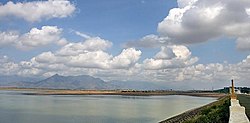
Dam | |
---|---|
Official name | வைகை அணை |
Country | India |
Location | periyakulam, Theni district, Tamil Nadu |
Coordinates | 10°03′12″N77°35′23″E / 10.05333°N 77.58972°E |
Opening date | 29 January 1959 |
Dam and spillways | |
Height | 33.8 m (111 ft) |
Length | 3,560 m (11,680 ft) |
Reservoir | |
Total capacity | 174,000,000 m3 (6.144752010×10⁹ cu ft) [1] (6.14 tmc ft) |
Power Station | |
Operator(s) | Tamil Nadu Generation and Distribution Corporation Limited |
Commission date | 3 April 1990 |
Type | Gravity dam |
Turbines | 2 x 3 MW |
Installed capacity | 6 MW |
The Vaigai Dam is built across the Vaigai River near Andipatti, in the Theni district (Madura district, before British India) of Tamil Nadu, South India. Near the dam, the Government of Tamil Nadu has constructed an Agricultural Research Station to research the cultivation of various crops, including rice, sorghum, black gram, cowpea and cotton. [2]
Vaigai Dam was inaugurated on 21 January 1959 [3] by the then Chief Minister K. Kamaraj. [4] It is one of the few dams not constructed between two mountains, so this dam completely depends on its concrete strength. The dam is the lifeline of farmers in six districts, namely Theni, Dindigul, Madurai, Sivagangai, Virudhunagar and Ramanathapuram. It provides water for irrigation in these districts and also serves as a source of drinking water for major cities such as Theni, Madurai, and Ramanathapuram, which lie along its riverbed. [5]
Vaigai Dam measures 111 feet in height and can store water up to 71 feet, with a total storage capacity of 6,143 million cubic feet or 6.14 thousand million cubic feet. [4] [1]
Vaigai Dam is maintained by Water Resources Department which in turn managed by the Tamil Nadu Public Works Department. [6]
A small park that has a children’s play area is maintained on both sides of the dam. A small bridge connects the two sides of the park in front of the dam. A musical dancing fountain functions between 6:00 AM and 8:00 PM on weekends and during government holidays. [7]
Vaigai Hydroelectric Power Plant was design capacity of 6 MW. It has 2 unit(s) of 3 MW each. The first unit was commissioned in 1990. It is operated by Tamil Nadu Generation and Distribution Corporation Limited (TANGEDCO). [8] [9]
Vaigai Dam is one of the 104 dams in Tamil Nadu that is proposed to be improved under the Dam Rehabilitation and Improvement Project ( DRIP). [10]
By Road:The dam is situated at 9 km from Andipatti, 14 km from Theni and 70 km from Madurai.
By Train:The nearest railway station is Andipatti Railway station which is located 10 km away from the dam. [11]
By Air:The nearest airport is Madurai Airport(IXM) which is 80 km away from the Dam. Air connectivity is available from Chennai, Mumbai, Delhi, Hyderabad, and Vijayawada. International connectivity is available to Colombo, [12] Dubai [13] and Singapore.
Sivaganga is a Town and headquarters of the Sivaganga district in the Indian state of Tamil Nadu.
The Vaigai is a river in the Tamil Nadu state of southern India; it passes through the towns of Theni, Madurai and Ramanathapuram. It originates in Varusanadu Hills, the Periyar Plateau of the Western Ghats range, and flows northeast through the Kambam Valley, which lies between the Palani Hills to the north and the Varushanad Hills to the south. The Vattaparai Falls are located on this river. As it rounds the eastern corner of the Varushanad Hills, the river turns southeast, running through the region of Pandya Nadu. Madurai, the largest city in the Pandya Nadu region and its ancient capital, lies on the Vaigai. The river empties into the Palk Bay near Alagankulam, close to Pamban Bridge in Ramanathapuram District.
Madurai district is one of the 38 districts of the state of Tamil Nadu in southeastern India. The city of Madurai serves as the district headquarters. It houses the famous Sri Meenakshi Sundareshwarar temple and is situated on the banks of the river Vaigai. Thiruparankundram is one of the major tourist place in the district. As of 2011, the district had a population of 3,038,252 with a sex-ratio of 990 females for every 1,000 males. Aside from the city of Madurai, the larger towns are Melur, Vadipatti, Thirumangalam, Thirupparankundram, Peraiyur, and Usilampatti. It is an important hub for various film shootings. Alanganallur is a popular spot in the district for Jallikattu, as are Palamedu and Avaniyapuram.
Ramanathapuram District, also known as Ramnad District, is one of the 38 districts an administrative districts of Tamil Nadu state in southern India. The old Ramanathapuram District consists of Present day Virudhunagar and Sivagangai districts, it touches the Western ghats and bordered with the state of Kerala and east by Bay of Bengal. It was the largest district on that time. The town of Ramanathapuram is the district headquarters. Ramanthapuram District has an area of 4,123 km2. It is bounded on the north by Sivaganga District, on the northeast by Pudukkottai District, on the east by the Palk Strait, on the south by the Gulf of Mannar, on the west by Thoothukudi District, and on the northwest by Virudhunagar District. The district contains the Pamban Bridge, an east–west chain of low islands and shallow reefs that extend between India and the island nation of Sri Lanka, and separate the Palk Strait from the Gulf of Mannar. The Palk Strait is navigable only by shallow-draft vessels. As of 2011, Ramanathapuram district had a population of 1,353,445 with a sex-ratio of 983 females for every 1,000 males. The district is home to the pilgrimage center of Rameswaram and tourist spot Dhanushkodi, an abandoned town.
Theni District is one of the 38 districts of Tamil Nadu state in India. Well protected by the scenic hill locks, the district is located besides Madurai district. The town of Theni is the district headquarters. The district is divided into two natural divisions: The hilly areas are constituted by parts of the five taluk's Theni, Bodinayakanur, Periyakulam, Uthamapalayam and Andipatti with thick vegetation and perennial streams from the hills on the western side and Cumbum valley which lies in Uthamapalayam taluk. As of 2011, Theni district had a population of 1,245,899 with a sex ratio of 980 females for every 1,000 males.
Andipatti or Aundipatty is a municipal body in Theni district in Madurai Region of Tamil Nadu state in southern India. It is on the bank of Vaigai River with rich flora and fauna species. It is a valley surrounded by mountains and there is a theory saying Western Ghats starts from this place.
Periyakulam is a major town and a municipality in Theni district, in the Madurai Region, South Indian state of Tamil Nadu. As of 2011, the town had a population of 42,976. Periyakulam is the northern gateway of the district.
Theni Allinagaram is a valley town and a municipality, situated in the Indian state of Tamil Nadu at the foothills of Western Ghats. It is the headquarters of the Theni district, located at a distance of 70 km from Madurai. As of 2011, the town had a population of 94,453. The metro area had the population of 202,100. It is known for the large-scale trading of garlic, cotton, cardamom, grapes, bananas, mango and chilli. It hosts the second largest weekly market in Tamil Nadu and the fourth largest in South India.
Mullaperiyar Dam is a masonry gravity dam on the Periyar River of Idukki district of Indian state of Kerala. It is situated 150km south east of Kochi. It is located 881 m (2,890 ft) above the sea level, on the Cardamom Hills of the Western Ghats in Thekkady, Idukki District of Kerala, India. It was constructed between 1887 and 1895 by John Pennycuick and also reached in an agreement to divert water eastwards to the Madras Presidency area. It has a height of 53.6 m (176 ft) from the foundation, and a length of 365.7 m (1,200 ft). The Periyar National Park in Thekkady is located around the dam's reservoir. The dam is built at the confluence of Mullayar and Periyar rivers. The dam is located in Kerala on the river Periyar, but is operated and maintained by the neighbouring state of Tamil Nadu. Although the Periyar River has a total catchment area of 5398 km2 with 114 km2 downstream from the dam in Tamil Nadu, the catchment area of the Mullaperiyar Dam itself lies entirely in Kerala and thus not an inter-State river. On 21 November 2014, the water level hit 142 feet for first time in 35 years. The reservoir again hit the maximum limit of 142 feet on 15 August 2018, following incessant rains in the state of Kerala. In a UN report published in 2021, the dam was identified as one among the world's big dams which needs to be decommissioned for being 'situated in a seismically active area with significant structural flaws and poses risk to 3.5 million people if the 100+ years old dam were to fail'.
Vadugapatti is a village in Periyakulam Taluk, Theni district, Madurai Region in the Indian state of Tamil Nadu.
Meghamalai, commonly known as the High Wavy Mountains, is a mountain range located in the Western Ghats in the Theni district near Kumily, Tamil Nadu. It is dotted with cardamom plantations and tea plantations. The mountain range is 1,500 metres above sea level, and it is rich in flora and fauna. The area, now mostly planted with tea plants, includes cloudlands, high wavys, venniar, and the manalar estates belonging to the Woodbriar Group. Access is largely restricted and includes largely untouched remnants of evergreen forest.
National Highway 49 was a National Highway in southern India under former numbering system.. It traversed coast-to-coast linking Kochi in Kerala with Dhanushkodi in Tamil Nadu. It crosses the famous Pamban Bridge before crossing into Rameswaram island. The total length runs up to 440 km (270 mi). The 5 km road between Mukundarayar Chathiram and Dhanuskodi was destroyed during the 1963 cyclone and was rebuilt.
Colonel John PennycuickCSI was a British Army engineer and civil servant who served as a member of the Madras Legislative Council. He undertook several irrigation works which included the masonry dam of Mullaperiyar on the Periyar River.
The Tamil Nadu Generation and Distribution Corporation Limited (TANGEDCO) is an electrical power generation and distribution public sector undertaking owned by the Government of Tamil Nadu. It was formed on 1 November 2010 under section 131 of the Electricity Act of 2003, and is the successor to the erstwhile Tamil Nadu Electricity Board. The electricity board's generation and distribution wings are its nucleus. TANGEDCO is a subsidiary of TNEB Limited.
The Papanasam dam also known as Karaiyar Dam is located 49 kilometres (30 mi) away from Tirunelveli in Tamil Nadu, India. The dam is used to irrigate 86,107 acres (34,846 ha) of paddy fields in Tirunelveli and Tuticorin districts.
Varusanadu is a village panchayat in Theni District of Tamil Nadu, which is located in the bank of Vaigai River. This village comes under Kadamalaigundu - Mayiladumparai Panchayat union and Andipatti Taluk.
The Karuppanadhi Dam is located at the foothills of Western Ghats built across the Karuppanadhi river near Chokkampatti, in the Tirunelveli district of Tamil Nadu, southern India. It provides water for irrigation to the region of Kadayanallur Taluk.
The Servalar Dam was set up for power generation in 1986, with a capacity of 1225 million cubic feet. The peak water level of the dam is 156 ft. The water drained out of the dam's power plant is again stored in Papanasam Dam for irrigation.
Venkatachalapuram is a small village situated in Theni District, Tamil Nadu, India and with direct road connectivity to Theni and Odaipatti. The district headquarters, Theni, is situated 11 kilometres (6.8 mi) north of this village.
Madurai Metro, is a proposed rapid transit system for Madurai, Tamil Nadu. It arose from a Madurai Metrolite system, part of a major expansion of public transport in the city and one of the projects devised by the former Chief Minister of Tamil Nadu J.Jayalalithaa.
{{cite web}}
: CS1 maint: unfit URL (link){{cite web}}
: CS1 maint: multiple names: authors list (link) CS1 maint: numeric names: authors list (link)