After experiencing fluctuations in the decades immediately after Indian independence, the economies of South Indian states have registered a sustained higher-than-national-average growth over the past three decades. South India has the largest combined largest gross domestic product compared to other regions in India. The South Indian states lead in some socio-economic metrics of India with a higher HDI as the economy has undergone growth at a faster rate than in most northern states. As of 2011, literacy rates in the southern states is higher than the national average at approximately 76%. The fertility rate in South India is 1.9, the lowest of all regions in India.
Etymology
"South India" is also known as "Peninsular India" indicating its location in a peninsula surrounded by water on three sides.[4] The term "Deccan", referring to the area covered by the Deccan Plateau that covers most of peninsular India excluding the coastal areas, is an anglicised form of the Prakrit word dakkhiṇa derived from the Sanskrit word dakshiṇa meaning south.[5]Carnatic, derived from "Karnāḍ" or "Karunāḍ" meaning black country, has also been associated with South India.[6]
After Indian Independence in 1947, the region was organized into the states of Madras State, Mysore State, Hyderabad State, and Travancore-Cochin.[16]Dravida Nadu was a proposal for a separate sovereign state for the speakers of the Dravidian languages in South India. Initially, the demand of Dravida Nadu proponents was limited to Tamil-speaking regions, but it was later expanded to include other Indian states with a majority of Dravidian-speakers in the region.[17] The States Reorganisation Act 1956, which reorganized the states based on linguistic lines, weakened the demand for a separate sovereign state.[18][19]
South India is a peninsula in the shape of an inverted triangle bound by the Indian Ocean in the South, the Arabian Sea in the west, the Bay of Bengal in the east and the Vindhya and Satpura ranges in the north.[27] The Narmada River flows westwards in the depression between the Vindhya and Satpura ranges, which define the northern spur of the region.[28] The southernmost tip of mainland India is at Kanyakumari where the Indian Ocean meets the Bay of Bengal and the Arabian Sea.[29] The Palk Strait, the Gulf of Mannar, and the chain of low sandbars and islands known as Rama's Bridge separate the region from Sri Lanka, which lies off the southeastern coast of the Indian mainland.[30][31]
The low-lying islands of Lakshadweep are situated off the southwestern coast of India.[32] In the Lakshadweep, the Eight Degree Channel separates the Laccadive and Amindivi Islands from the Minicoy Island to the south.[33]Laccadive Sea is a smaller sea.[34] There are coral reefs located in the Gulf of Mannar and the Lakshadweep islands.[35]
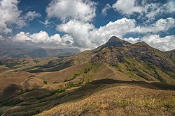
The peak of Anamudi is the highest point of elevation in South India
The Western Ghats runs south along the western coast from south of the Tapti river to Kanyakumari and forms a narrow strip of land with the Arabian Sea, divided into Konkan and Malabar regions.[36]Anaimudi in the Anaimalai Hills in the Western Ghats is the highest peak in South India at 2,695m (8,842ft).[37] The Eastern Ghats run parallel to the eastern coast along the Bay of Bengal and the strip of land between them forms the Coromandel region.[38] They are a discontinuous range of mountains, which have been eroded and quadrisected by the four major rivers of South India–Godavari, Mahanadi, Krishna, and Kaveri.[39] Both the mountain ranges meet at Nilgiris, which run in a crescent approximately along the borders of Tamil Nadu with northern Kerala and Karnataka, encompassing the Palakkad and Wayanad hills and the Sathyamangalam ranges, and extending to the relatively low-lying hills of the Eastern Ghats on the western portion of the Tamil Nadu–Andhra Pradesh border, forming the Tirupati and Annamalai hills.[40]
The Deccan Plateau is the elevated region bound by the mountain ranges.[41] The plateau rises to 100m (330ft) in the north and to more than 1km (0.62mi) in the south, forming a raised triangle within the downward-pointing triangle of the Indian subcontinent's coastline.[42] It also slopes gently from West to East resulting in major rivers arising in the Western Ghats and flowing east into the Bay of Bengal.[43] The volcanic basalt beds of the Deccan were laid down in the massive Deccan Traps eruption, which occurred towards the end of the Cretaceous period, between 67 and 66 million years ago.[44] Multiple layers were formed by repeated volcanic activity that lasted many years and when the volcanoes became extinct, they left a region of highlands with typically vast stretches of flat areas on the top.[45] Large lakes in the region include Vembanad, and Pulicat Lakes.[46]
Climate
Climatic zonesMonsoon onset
The region has a tropical climate and depends on monsoons for rainfall. According to the Köppen climate classification, it has a non-arid climate with minimum mean temperatures of 18°C (64°F).[47] The humid tropical monsoon climate characterised by moderate to high year-round temperatures and seasonally heavy rainfall above 2,000mm (79in) per year, is experienced in a strip of south-western lowlands abutting the Malabar Coast, the Western Ghats, and the Lakshadweep islands.[48]
A tropical wet and dry climate, drier than areas with a tropical monsoon climate, prevails over most of the inland peninsular region except for a semi-arid rain shadow east of the Western Ghats. Winter and early summer are long dry periods with temperatures averaging above 18°C (64°F); summer is exceedingly hot with temperatures in low-lying areas exceeding 50°C (122°F); and the rainy season lasts from June to September, with annual rainfall averaging between 750 and 1,500mm (30 and 59in) across the region. Post September, only parts of Tamil Nadu receives precipitation, leaving other states comparatively dry.[49] A hot semi-arid climate predominates in the land east of the Western Ghats and the Cardamom Hills. The region – which includes Karnataka, inland Tamil Nadu and western Andhra Pradesh – gets between 400 and 750mm (16 and 30in) of rainfall annually, with hot summers and dry winters with average temperatures of 20–24°C (68–75°F). The months between March and May are hot and dry, with mean monthly temperatures hovering around 32°C (90°F), with an average of 320mm (13in) precipitation. Without artificial irrigation, this region is not suitable for agriculture.[50]
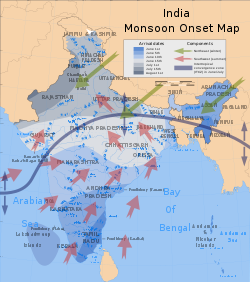
The southwest monsoon from June to September accounts for most of the rainfall in the region. The Arabian Sea branch of the southwest monsoon hits the Western Ghats along the coastal state of Kerala and moves northward along the Konkan coast, bringing rainfall to the coastal areas west of the Western Ghats. The lofty Western Ghats prevent the winds from reaching the interior of the Deccan Plateau, resulting in the leeward region (the region deprived of winds) receiving very little rainfall.[51][52] The Bay of Bengal branch of the southwest monsoon heads toward northeast India, picking up moisture from the Bay of Bengal. The Coramandel coast does not receive much rainfall from the southwest monsoon, due to the shape of the land. Tamil Nadu and southeastern Andhra Pradesh receive rains from the northeast monsoon.[53] The northeast monsoon takes place from November to early March, when the surface high-pressure system is strongest.[54] The North Indian Ocean tropical cyclones occur throughout the year in the Bay of Bengal and the Arabian Sea, bringing devastating winds and heavy rainfall.[55][56][57]
Politics in South India is characterized by a mix of regional and national political parties. The Justice Party and Swaraj Party were the two major parties in the erstwhile Madras Presidency. The Justice Party eventually lost the 1937 elections to the Indian National Congress, and Chakravarti Rajagopalachari became the Chief Minister of the Madras Presidency.[88] During the 1920s and 1930s, the Self-Respect Movement, spearheaded by Theagaroya Chetty and E. V. Ramaswamy (Periyar), emerged in the Madras Presidency.[89] In 1944, Periyar transformed the party into a social organisation, renaming the party Dravidar Kazhagam, and withdrew from electoral politics, with the initial aim of secession from the rest of India upon Indian independence.[90]
The Congress continues to be a major party in Karnataka, Kerala, Puducherry, and Telangana. The party ruled with minimal opposition for 30 years in Andhra Pradesh, before the formation of the Telugu Desam Party by Nandamuri Taraka Rama Rao in 1982.[98] In Karnataka, the Bharatiya Janata Party and Janata Dal (Secular) emerged as significant parties in the late 20th century.[99] Two prominent coalitions in Kerala are the United Democratic Front, led by the Congress, and the Left Democratic Front, led by the Communist Party of India (Marxist). For the past fifty years, these two coalitions have been alternately in power; and E. M. S. Namboodiripad, the first elected chief minister of Kerala in 1957, is credited as the leader of the first democratically elected communist government in the world.[100][101] Parties which split from the Congress such as YSR Congress in Andhra Pradesh, and All India N.R. Congress in Puducherry, have emerged as significant regional parties in their respective regions.[102][103] The Telangana Rashtra Samithi emerged as a prominent party in Telangana, after its campaign for statehood for Telangana and the state's formation in 2014.[104]
South India consists of the five southern Indian states of Andhra Pradesh, Telangana, Karnataka, Kerala, and Tamil Nadu, and the union territories of Puducherry, and Lakshadweep.[114][115] Puducherry and the five states each have an elected legislature, while Lakshadweep is administered by the union government.[116][117]
A governor, who is appointed by the president of India, is the de jure head of the government in the states. The governor appoints the leader of the state legislature's ruling party or coalition as the chief minister, who is the de facto head of the government.[118][119]
South India elects 132 members to the Lok Sabha, accounting for roughly one-fourth of the total strength.[131] The region is allocated 58 seats in the Rajya Sabha, out of the total of 245.[132]
The state legislatures of Tamil Nadu, Kerala and Puducherry are unicameral, while Andhra Pradesh, Karnataka, and Telangana have bicameral legislatures.[133][134] States with bicameral legislatures have an upper house (Legislative Council) with members not more than one-third the size of the Assembly. State legislatures elect members for terms of five years. Governors may suspend or dissolve assemblies and can administer when no party is able to form a government.[123]
↑Telangana was subdivided from Andhra Pradesh on 2 June 2014.[128][129]Hyderabad, located entirely within the borders of Telangana, served as the joint capital for both the states initially.[130]
As per the 2011 census of India, the estimated population of South India was 252 million, around one fifth of the total population of the country. The region's total fertility rate (TFR) was less than the population replacement level of 2.1 set by the United Nations, with Kerala and Tamil Nadu having the lowest TFRs in India at 1.7.[135][136] As a result, the proportion of the population of South India to India's total population has shown a declining trend from 1981 to 2011.[137][138]Scheduled Castes and Tribes form 18% of the population of the region.[139] Agriculture is the major employer in the region, with 47.5% of the population being involved in agrarian activities.[140] About 60% of the population lives in permanent housing structures.[141] In 2011, about 67.8% of the people in South India had access to tap water, with wells and springs being major sources of water supply.[142]
After experiencing fluctuations in the decades immediately after the independence of India, the economies of South Indian states have, over the past three decades, registered growth higher than the national average. While South Indian states have improved in some of the socio-economic metrics,[143] poverty continues to affect the region as it does the rest of the country, although it has considerably decreased over the years. The HDI in the southern states is high, and the economy has grown at a faster rate than those of most northern states.[144][145][146]
As per the 2011 census, the average literacy rate in South India is approximately 80%, considerably higher than the Indian national average of 74%, with Kerala having the highest literacy rate of 93.91%.[147] South India has a higher sex ratio than the national average with Kerala and Tamil Nadu being the top two states in the country.[148] The South Indian states rank amongst the top half in economic freedom,[149]access to electricity,[150]access to drinking water,[151]house ownership,[152]TV ownership[153], and lower poverty rate.[154] In early 2010s, the average per capita income of the South Indian states was ₹19,531 (US$230), more than double of the average of other Indian states (₹8,951 (US$110)).[155][156] Of the three demographically related targets of the Millennium Development Goals set by the United Nations and expected to be achieved by 2015, Kerala and Tamil Nadu achieved the goals related to improvement of maternal health and of reducing infant mortality and child mortality by 2009.[157][158]
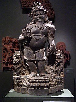
Evidence of prehistoric religion in South India comes from scattered Mesolithic rock paintings depicting dances and rituals, such as the Kupgal petroglyphs of eastern Karnataka, at Stone Age sites.[175]Hinduism, regarded as one of the oldest religions.[176] is the major religion in South India, with about 82.6% of the population adhering to it.[177] Its major spiritual traditions include Shaivism and Vaishnavism, although Buddhist and Jain philosophies were also influential earlier.[178]Ayyavazhi originated in South India in the 19th century.[179][180]
Islam was introduced to the Malabar Coast in the early 7th century CE by the Arab traders, and spread during the rule of the Deccan Sultanates, in the 17th and 18th centuries.[181]As of 2011[update], about 11.6% of the population In South India follow the religion.[182]Christianity was introduced to South India by Thomas the Apostle, who visited Muziris in Kerala in 52 CE and proselytised the natives.[183]As of 2011[update], about 5.1% of the population follow the religion.[177] Kerala is also home to one of the oldest Jewish communities in the world, who are supposed to have arrived on the Malabar coast during the reign of King Solomon.[184][185][186]
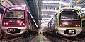
Currently, operational metro systems are there in four cities Chennai, Bengaluru, Hyderabad and Kochi.[224][225]Chennai Suburban founded in 1928 is one of the oldest and largest urban networks in the country.[226] Opened in 1995, Chennai MRTS was the first elevated urban railway in India.[226]Hyderabad MMTS was opened in 2003, becoming the second city in South India to have a local rail transit system.[227] As of December 2022, South India has 205.06km of operational metro lines and 16 systems.[228]
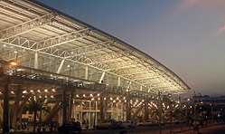
In 1915, Tata Sons started a regular airmail service between Karachi and Madras marking the beginning of air transportation in the southern part of India.[236] In March 1930, a discussion initiated by pilot G. Vlasto led to the founding of the Madras Flying Club, which became a pioneer in pilot training in South India.[237][238] On 15 October 1932, Indian aviator J. R. D. Tata flew a Puss Moth aircraft carrying mail from Karachi to Juhu aerodrome, Bombay; and the aircraft continued to Madras, piloted by Neville Vincent, a former Royal Air Force pilot and friend of Tata.[239][240]
The region is covered by water on three sides and has a long coastline. A total of 67 ports are situated in South India: Tamil Nadu (18), Kerala (14), Andhra Pradesh (13), Karanataka (11), Lakshadweep (10) and Pondicherry (1).[247] Major ports include Visakhapatnam, Chennai, Mangalore, Tuticorin, Ennore and Kochi.[247]
The Kerala backwaters are a network of interconnected canals, rivers, lakes, and inlets, a labyrinthine system formed by more than 900km of waterways.[250] The Eastern Naval Command and Southern Naval Command of the Indian Navy are headquartered at Visakhapatnam and Kochi respectively.[251][245] In the region, the Indian Navy has its major operational bases at Visakhapatnam, Chennai, Kochi, Karwar, and Kavaratti.[252]Kochi Water Metro is the first water metro service in India launched in 2023.[253]
Chennai, known as the "Gateway to South India", is an automotive hub; Pictured is headquarters of Ashok Leyland
After independence, the economy of South India conformed to a socialist framework, with strict governmental control over private sector participation, foreign trade, and foreign direct investment. From 1960 to 1990, the South Indian economies experienced mixed economic growth. In the 1960s, Kerala achieved above-average growth while Andhra Pradesh's economy declined. Kerala experienced an economic decline in the 1970s while the economies of Karnataka, Tamil Nadu, and Andhra Pradesh consistently exceeded national average growth rates, due to reform-oriented economic policies.[254] As of March 2015, there are 109 operational Special Economic Zones in South India, which is about 60% of the country's total.[255] As of 2019–20, the total gross domestic product of the region is ₹67 trillion (US$946 billion). Tamil Nadu has the second-highest GDP and is the second-most industrialised state in the country after Maharashtra.[256] With the presence of two major ports, an international airport, and a converging road and rail networks, Chennai is referred to as the "Gateway of South India".[257][258] South India contributes 30% of India's GDP[259][260] with a higher per capita income and lower debt-to-GDP ratio than the national average.[259][260] According to the Globalization and World Cities Research Network, Bengaluru, Chennai and Hyderabad are amongst the most integrated with the global economy with Bengaluru classified as an alpha- city, Chennai as beta and Hyderabad as beta-.[261]
Other major agricultural products include poultry and silk.[274][275] Being a peninsular region, aquaculture is a major contributor to the economy. As of 2017–18, the region produced 53.68 lakh tonnes fish contributing to nearly 43% of total fish production in India.[276] Like most of the Indian subcontinent, agriculture in the region is largely dependent on seasonal monsoons[277] and monsoon failure often leads to droughts forcing farmers into debt, selling livestock and sometimes into committing suicide.[278][279]
Information technology
Bangalore is an alpha-city and a major information technology hub. Picture: Infosys
South India's urban centres are significant contributors to the Indian and global IT economy. Bengaluru, Chennai, Hyderabad, Coimbatore, Kochi and Thiruvananthapuram are amongst the major information technology (IT) hubs of India.[280][281][282][283][284] The presence of these hubs has spurred economic growth and attracted foreign investments and job seekers from other parts of the country.[285] Software exports from South India grossed over ₹640 billion (US$7.6billion) in fiscal 2005–06.[286]
Defense establishments include Hindustan Aeronautics Limited in Bangalore which manufactures fighter aircraft, helicopters and aircraft components.[295]DRDO which is India's premier defense agency operates various facilities in Chennai, Bangalore, Hyderabad and Mysuru in South India.[296]
Tourism contributes significantly to the GDP of the region, with four states – Tamil Nadu, Andhra Pradesh, Karnataka, and Telangana – among the top 10 states for tourist arrivals, accounting for more than 50% of domestic tourist visits.[305]
Tamil Nadu has the largest tourist inflow in India both domestic and international as of 2020.[306] In 2023, Kerala was listed at the 13th spot in The New York Times' annual list of places to visit and was the only tourist destination listed from India.[307] Kerala was named by TIME magazine in 2022 among the 50 extraordinary destinations to explore in its list of the World's Greatest Places.[308]
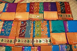
South Indian women traditionally wear a sari, a garment that consists of a drape varying from 15–27ft (4.6–8.2m) in length and 2–4ft (0.61–1.22m) in breadth, and is typically wrapped around the waist, with one end draped over the shoulder, baring the midriff, as the navel is considered as the source of life and creativity in Indian philosophy.[310][311] Ancient Tamil poetry such as the Silappadhikaram, describes women in exquisite drapery or sari.[312]Madisar is a typical style worn by Brahmin women from Tamil Nadu.[313] Women wear colourful silk sarees on special occasions such as marriages.[314]Kanchipuram silk sari is a type of silk sari made in the Kanchipuram region in Tamil Nadu, worn by brides during marriages and as dresses for special occasions by most women in South India. It has been recognized as a Geographical indication by the Government of India in 2005–2006.[315][316]Kovai Cora Cotton is a type of cotton sari made in the Coimbatore.[317][318]
The men wear a dhoti, a 4.5m (15ft) long, white rectangular piece of non-stitched cloth often with brightly coloured stripes at the border. It is usually wrapped around the waist and the legs and knotted at the waist.[319] A colourful lungi with typical batik patterns is the most common form of male attire in the countryside.[320]
People in urban areas generally wear tailored clothing, and western dress is popular. Western-style school uniforms are worn by both boys and girls in schools, even in rural areas.[320]Calico, a plain-woven textile made from unbleached and often not fully processed cotton, originated at Kozhikode in the 11th century CE,[321] and was known as Chaliyan.[322] The raw fabric was dyed and printed in bright hues, and calico prints later became popular in the Europe.[323]
The traditional way of eating a meal involves being seated on the floor, having the food served on a banana leaf,[327] and using clean fingers of the right hand to take the food into the mouth.[328] After the meal, the fingers are washed; the easily degradable banana leaf is discarded or becomes fodder for cattle.[329] Eating on banana leaves is a custom thousands of years old, imparts a unique flavor to the food, and is considered healthy.[330]
South India has an independent literary tradition dating back to over 2500 years. The earliest known literature of South India is the poetic Sangam literature, which was written in Tamil and is dated back to the Sangam period (300 BCE to 300 CE). Tamil literature from the period was composed in three successive poetic assemblies known as Tamil Sangams, the earliest of which, according to ancient tradition, were held on a now vanished continent far to the south of India.[349][350] Early Tamil literature include the oldest grammatical treatise, Tholkappiyam, and the epics Silappatikaram and Manimekalai.[351]
South India has two distinct styles of rock architecture, the Dravidian style of Tamil Nadu, Andhra Pradesh and the Vesara style of Karnataka, Telangana.[356] The architecture of Kerala is unique and emerged from the Dravidian architecture.[357]
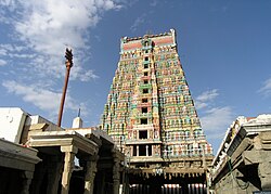
In Dravidian architecture, the temples considered of porches or mandapas preceding the door leading to the garbagriha (sanctum). Large gopurams (gate-pyramids) located atop the entrances to large quadrangular enclosures that surround the main sanctum and large pillared halls are usual features of these temples. Besides these, a South Indian temple usually has a tank called the kalyani or pushkarni.[358] The gopuram is a monumental tower, usually ornate at the entrance of the temple forms a prominent feature of koils and Hindu temples of the Dravidian style.[359] They are topped by the kalasam, a bulbous stone finial and function as gateways through the walls that surround the temple complex.[360] The gopuram's origins can be traced back to the Pallavas who built the group of monuments in Mahabalipuram and Kanchipuram.[361] The Cholas later expanded the same, and by the Pandya rule in twelfth century, these gateways became a dominant feature of a temple's outer appearance.[362][363]Vimanam are similar structures built over the garbhagriha or inner sanctum of the temple. In the Dravidian architecture, these are usually smaller than the gopurams with a few exceptions such as the Brihadisvara Temple in Thanjavur.[364][365]
AVM studios in Chennai, the oldest surviving studio in India
Films done in regional languages are prevalent in South India, with several regional cinemas being recognized: Kannada cinema (Karnataka), Malayalam cinema (Kerala), Tamil cinema (Tamil Nadu), and Telugu cinema (Andhra Pradesh and Telangana). The first silent film in South India, Keechaka Vadham, was made by R. Nataraja Mudaliar in 1916.[371] Mudaliar also established Madras's first film studio.[372] The first Tamil talkie, Kalidas, was released on 31 October 1931, barely seven months after India's first talking picture, Alam Ara.[373]
All South Indian states rank in the top ten in institutional delivery in India[380] and life expectancy.[381] The region also has a lower infant and child mortality compared to the national average.[136] Chennai attracts about 45 percent of health tourists coming to India and is known as India's health capital.[382]As of 2017[update], there are 9,482 public health facilities run by the respective state governments. Apart from these, there are 676 AYUSH facilities, 11 defence hospitals, 32 hospitals run by Indian Railways, and 39 hospitals run by state insurance corporations.[383]
Public health facilities run by state/UT governments (2017)[383]
As per the 2011 census, the average literacy rate in South India is approximately 80%, considerably higher than the Indian national average of 74%, with Kerala having the highest literacy rate of 93.91%.[147]
↑Schoff, Wilfred (1912). The Periplus of the Erythraean Sea: Travel And Trade In The Indian Ocean By A Merchant Of The First Century. South Asia Books. ISBN978-8-121-50699-1.{{cite book}}: ISBN / Date incompatibility (help)
↑Indian National Evolution: A Brief Survey of the Origin and Progress of the Indian National Congress and the Growth of Indian Nationalism. Cornell University Press. 22 September 2009. p.59. ISBN978-1-112-45184-3.
123Reorganisation of states(PDF) (Report). Economic Weekly. 15 October 1955. Archived(PDF) from the original on 18 February 2016. Retrieved 31 December 2015.
↑Playne, Somerset; Bond, J. W; Wright, Arnold (2004). Southern India: its history, people, commerce, and industrial resources. Asian Educational Service. p.417. OCLC58540809.
↑Biosphere Reserves in India(PDF) (Report). Ministry of Environment, Forest and Climate Change. 2019. Archived(PDF) from the original on 5 February 2020. Retrieved 5 February 2020.
↑Baker, H.R.; Inglis, Chas. M. (1930). The birds of southern India, including Madras, Malabar, Travancore, Cochin, Coorg and Mysore. Chennai: Superintendent, Government Press.
↑Grimmett, Richard; Inskipp, Tim (30 November 2005). Birds of Southern India. A & C Black.
↑Aiyar, S.A. (26 June 2011). "Unsung hero of the India story". The Times of India. Archived from the original on 21 January 2014. Retrieved 30 August 2023. Twenty years ago, Narasimha Rao became Prime Minister and initiated economic reforms that transformed India
↑Thorpeand, Showick (2015). "Chapter 3". The Pearson Concise General Knowledge Manual 2016. Pearson Education India. p.17. ISBN978-9-3325-5884-7.
↑Espenshade, TJ; Guzman, JC; Westoff, CF (2003). "The surprising global variation in replacement fertility". Population Research and Policy Review. 22 (5/6): 580. doi:10.1023/B:POPU.0000020882.29684.8e. S2CID10798893.
↑Antony, G.M.; Laxmaiah, A. (20 April 2015). "Human development, poverty, health & nutrition situation in India"(PDF). The Indian Journal of Medical Research. 128 (2). Council of Social Development, Southern Regional Centre & Division of Community Studies National Institute of Nutrition: 198–205. PMID19001685. Archived from the original(PDF) on 8 August 2021. Retrieved 22 July 2015.
↑Caldwell, Robert (1998). A comparative grammar of the Dravidian or South-Indian family of languages (3rded.). New Delhi: Asian Educational Services. ISBN978-8-120-60117-8.
↑Mayaram, Shail; Pandian, M. S. S.; Skaria, Ajay (2005). Muslims, Dalits and the Fabrications of History. Permanent Black and Ravi Dayal Publishers. pp.39–. ISBN978-8-178-24115-9.
↑Year at a glance(PDF) (Report). Ministry of Road Transport and Highways, Government of India. p.3. Archived(PDF) from the original on 20 November 2023. Retrieved 19 March 2023.
↑"Profile, APSRTC"(PDF). Government of Andhra Pradesh. Archived(PDF) from the original on 31 March 2023. Retrieved 20 March 2023.
↑About TNSTC(PDF) (Report). Government of Tamil Nadu. Archived(PDF) from the original on 31 March 2023. Retrieved 20 March 2023.
↑List of highways by state(PDF) (Report). Ministry of Road Transport & Highways, Government of India. Archived(PDF) from the original on 30 June 2024. Retrieved 21 June 2023.
1234Brief History of the Division(PDF). Chennai Division (Report). Indian Railways—Southern Railways. Archived(PDF) from the original on 30 May 2012. Retrieved 26 October 2012.
↑Higham, Robin (1961). Britain's Imperial Air Routes, 1918 to 1939. Shoe String Press. p.168. ISBN978-0-2080-0171-9.{{cite book}}: ISBN / Date incompatibility (help)
↑"De Havilland Gazette". De Havilland Aircraft Company: 103. 1953.
12List of ports(PDF) (Report). Government of India. p.1. Archived(PDF) from the original on 20 March 2023. Retrieved 29 August 2023.
↑Annual Report, 2022-23(PDF) (Report). Ministry of Shipping, Government of India. p.35. Archived(PDF) from the original on 1 September 2023. Retrieved 26 August 2023.
↑Annual Report, 2022-23(PDF) (Report). Ministry of Shipping, Government of India. p.47. Archived(PDF) from the original on 1 September 2023. Retrieved 26 August 2023.
↑Dykyjová, Dagmar; Whigham, Dennis F.; Hejný, Slavomil (1993). Inventory, Ecology, and Management. Vol.15. University of Wisconsin. p.358 – via Kluwer Academic Publishers.
↑Agricultural Statistics at a Glance 2021(PDF) (Report). Directorate of Statistics, Department of Agriculture, Government of India. pp.32–33. Archived(PDF) from the original on 18 September 2023. Retrieved 30 August 2023.
↑Indian States fish production(PDF) (Report). Department of fisheries, Government of India. p.23. Archived(PDF) from the original on 25 December 2022. Retrieved 23 August 2023.
↑Boulanger, Chantal (1997). Saris: An Illustrated Guide to the Indian Art of Draping. Shakti Press. ISBN978-0-966-14961-6.
↑Lynton, Linda (1995). The Sari. New York: Harry N. Abrams, Incorporated. ISBN978-0-810-94461-9.
↑Parthasarathy, R. (1993). The Tale of an Anklet: An Epic of South India – The Cilappatikaram of Ilanko Atikal, Translations from the Asian Classics. New York: Columbia University Press. ISBN978-0-231-07849-8.
↑Molina, A.B.; Roa, V.N.; Van den Bergh, I.; Maghuyop, M.A. (2000). Advancing banana and plantain R & D in Asia and the Pacific. Biodiversity International. p.84. ISBN978-9-719-17513-1.
↑Tamang, Jyoti Prakash (2020). Ethnic Fermented Foods and Beverages of India: Science History and Culture. Singapore: Springer Nature. p.211. ISBN978-9-811-51486-9.
↑Massey, Reginald (2004). India's Dances Their History, Technique, and Repertoire. New Delhi: Abhinav Publishers. ISBN978-8-170-17434-9.
↑Samson, Leela (1987). Rhythm in Joy: Classical Indian Dance Traditions. New Delhi: Lustre Press. p.29. ISBN978-9-991-94155-4.
↑The Handbook of Tamil Culture and Heritage. Chicago: International Tamil Language Foundation. 2000. p.1201.
↑Banerjee, Projesh (1 February 1989). Indian Ballet Dancing. New Jersey: Abhinav Publications. p.43. ISBN978-8-170-17175-1.
↑Bowers, Faubion (June 1953). The Dance in India. New York: AMS Press. pp.13–15. ISBN978-0-404-00963-2.{{cite book}}: ISBN / Date incompatibility (help)
↑Bezbaruah, Madan Prasad; Gopal, Krishna (2003). Fairs and Festivals of India. Vol.2. Gyan Publishing House. p.286. ISBN978-8-121-20809-3.
↑Beck, Brenda (1976). "The Symbolic Merger of Body, Space, and Cosmos in Hindu Tamil Nadu". Contributions to Indian Sociology. 10 (2): 213–243. doi:10.1177/006996677601000202. S2CID143220583.
↑Zvelebil, Kamil (1973). The smile of Murugan on Tamil literature of South India. Leiden. Zvelebil dates the Ur-Tolkappiyam to the 1st or 2nd century BCE
↑Ramaswamy, Vijaya (1993). "Women and Farm Work in Tamil Folk Songs". Social Scientist. 21 (9/11): 113–129. doi:10.2307/3520429. JSTOR3520429. As early as the Tolkappiyam (which has sections ranging from the 3rd century BC to the 5th century AD) the eco-types in South India have been classified into
↑Finkel, Irving (2004). "Round and Round the Houses: The Game of Pachisi". In Mackenzie, Colin; Finkel, Irving (eds.). Asian Games: The Art of Contest. Asia Society. pp.46–57. ISBN978-0-878-48099-9.
↑Raj, J. David Manuel (1977). The Origin and the Historical Development of Silambam Fencing: An Ancient Self-Defence Sport of India. College of Health, Physical Education and Recreation, University of Oregon. pp.44, 50, 83.
This page is based on this Wikipedia article Text is available under the CC BY-SA 4.0 license; additional terms may apply. Images, videos and audio are available under their respective licenses.