| No. | Image | Geo-Heritage site | Location | District | State | Geotourism Category and reference |
|---|
| 1 | 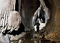 | Mawmluh Cave | Cherrapunji | East Khasi Hills district | Meghalaya | Geo-tourism: Cave belongs to Meghalayan Age, which is a major abrupt climatic event with critical drought and cooling 4,200 years ago which was determined from a stalagmite from Mawmluh cave. [8] In the geologic time scale, the Meghalayan is the latest age or uppermost stage of the Quaternary. [9] |
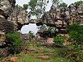
| 2 | | Mawblei God’s Rock | | East Khasi Hills district | Meghalaya | Geo-tourism: A megalith, Mahadek sandstone of Khasi group of cretaceous period, inclined at 45 degrees on a slope of a hill of Wahrashi River valley is a sacred site for Khasi people. [8] |
| 3 | | Therriaghat | | East Khasi Hills district | Meghalaya | Geo-tourism: Best-preserved and most complete Cretaceous-Paleogene boundary in India. Cretaceous–Paleogene extinction event at the end of the Cretaceous period caused sudden extinction of the large vertebrates, plankton and many tropical invertebrates. [8] |
| 4 | 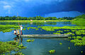 | Majuli | Majuli island | Majuli district | Assam | Geo-tourism: World's largest river island in Brahmaputra river has sacred Hindu Vaishnavite sampradaya's satra (kshetra or monasteries) set up by in 15th-16th century Srimanta Sankaradeva. The eco-region is conserved by the Srimanta Sankaradeva Sangha. [8] |
| 5 | | Umananda Island | Brahmaputra river | Guwahati | Assam | Geo-tourism: islet is an inselberg made of rocks of Assam-Meghalaya gneissic complex. [8] |
| 6 | 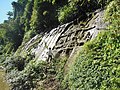 | Chabimura | | Gomati district | Tripura | Geo-tourism: 15th-16th century sacred Hindu site with rock carvings on a cliff of Gomti River with massive rock cut images of Shiva, Vishnu, Karthikeya, Durga and other Hindu deities highest of which is 20 ft. [8] |
| 7 |  | Unakoti | | Unakoti district | Tripura | Geo-tourism: 7th-9th centuries rock-cut sculptures and Shaiva temples. Unakotiswara Kal Bhairava shiva statue is 30 feet tall. [8] |
| 8 | 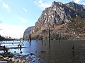 | Sangetsar Tso | | Tawang district | Arunachal Pradesh | Geo-tourism: Also called as Madhuri Lake, created by damming of river due to earthquake in 1950, is nestled in a lush valley midst of snowy mountain peaks and freezes in winter. [8] |
| 9 |  | Loktak Lake | | Bishnupur district | Manipur | Geo-tourism: It is a phumdi (floating biomass) with phumsangs (tribal huts of fishermen) which is also the Keibul Lamjao National Park - world's only floating wildlife habitat on the southwestern part of lake. [8] |
| 10 | 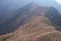 | Reiek Tlang | | Aizawl | Mizoram | Geo-tourism: It is a cuesta (a hill with a gentle slope on one side and a steep slope on the other) created by erosion of the tertiary sand shale alterations. [8] |
| 11 | | Nagahill Ophiolite Site | Pungro | Kiphire district | Nagaland | Geo-tourism: [8] |
| 12 |  | Mamley Stromatolite Park | Namchi | South Sikkim district | Sikkim | Geo-tourism: Also called "Buxa Formation of Mamley", is Algal mat#StromatolitesStromatolite Algal mat with circular structures in the limestone of Proterozoic Buxa Formation microbiota microfossils of Ranjit Window is rare examples of early life on Earth in the Sikkim Himalayas. [8] |