| Border | Ceremony Locations | Notes |
|---|
India-Pakistan border
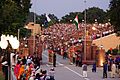
(listed north to south) | Attari–Wagah border ceremony near Amritsar in Punjab. [10] [11] | Joint daily India-Pak ceremony, most attended and emotionally charged ceremony. |
| Ganda Singh Wala–Hussainiwala border ceremony near Firozepur in Punjab. [10] [11] | Joint daily India-Pak ceremony with cafes. Indian side has tourist facilities, shops, Hussainiwala National Martyrs Memorial and museum of Bhagat Singh, Sukhdev Thapar and Shivaram Rajguru at the site of their cremation by British raj. |
| Sadqi-Sulemanki border ceremony near Fazilka in Punjab. [12] [13] [14] | Joint daily India-Pak ceremony with cafe on Indian side. |
| Hindumalkote in Sri Ganganagar district of Rajasthan | One-sided daily display by India's BSF with cafe, reachable by road or rail 18 km from Sri Ganganagar to Hindumalkote railway station though historic India-Pakistan railway link is now defunct. [15] |
| Khajuwala Satpal Border Outpost (BOP) in Bikaner district of Rajasthan | One-sided daily display by India's BSF with a Beating Retreat ceremony, tourist gallery, and cafe. [15] |
| Sanchu Post in Bikaner district of Rajasthan | One-sided occasional display by India's BSF with cafe and museum on Indian side surrounded by tall sand dunes, 38 km west of Ranjeetpura and 175 km west of Bikaner. [15] |
| Tanot/Longewala in Jaisalmer district in Rajasthan | One-sided occasional display by India's BSF with cafe and War Museum on Indian side which also shows the famous open-air battlefield with captured 1971 Pakistani tanks. [15] |
| Khokhrapar–Munabao border ceremony in Barmer district of Rajasthan. [10] [11] | Joint daily India-Pak ceremony. [15] |
| Nadabet of Vav-Tharad district in Gujarat | One-Sided Tue-Sun (closed Monday) display by India's BSF with a major tourist complex on India side which also has museum and cafe. [15] |
India-China border
(listed west to east) | Daulat Beg Oldi | Border Personnel Meeting Point (BPM Point) |
| Spanggur Gap (Chushul) | Border Personnel Meeting point, tourists on Indian side need Inner Line Permit (ILP). |
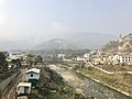
| Nathu La | Used for pilgrims to monasteries in Sikkim; reduces journey time to Lake Manasarovar. [16] Tourists to Nathu La on Indian side need ILP. |
| Bum La Pass (Tawang) | Open on Sundays and during cultural ceremonies, tourists La on Indian side need ILP. |
| Kaho (north of Kibithu in Walong sector) | Border Personnel Meeting point, tourists on Indian side need ILP. |
India-Bangladesh border
(listed clockwise from southwest) | Benapole–Petrapole border ceremony in North 24 Parganas district of West Bengal | Joint daily ceremony by BSF (Border Security Force) and BGB (Border Guards Bangladesh). [17] [18] 60-70 km northeast of Barasat and Kolkata. |
| Phulbari-Banglabandha in Darjeeling district of West Bengal | Joint daily ceremony 11 km south of Siliguri. |
| Changrabandha-Burimari in Cooch Behar district of West Bengal | Joint daily ceremony, 80 km southeast of SIlliguri and 70 km east of Cooch Bihar. |
| Agartala-Akhaura in Tripura | Joint daily ceremony, its the second-largest site on India-Bangladesh border 4km west of Agartala city. |