List of countries that border only one other country
Last updated
This is a list of sovereign state that have a land border with only one other. Some on this list have a maritime border with additional countries. Some which are not listed here have no land border but do have a maritime border with a single other state; an example is Sri Lanka.
a peninsula or a semi-enclave, where one state has a land border with a neighbouring one but is otherwise surrounded by sea, while the neighbour borders other states—examples are Portugal (neighbouring Spain), The Gambia (surrounded by Senegal) and Brunei (surrounded by Malaysia).
Territory leased or ceded by one country to another for perpetual use, but not in sovereignty, such as Guantanamo Bay Naval Base in Cuba, or memorials, such as the American Cemetery in France, do not constitute true territorial borders because the land occupied remains a formal part of the host country.
This list is based on the Correlates of War Direct Contiguity data set, with maritime causeways, bridges and artificial islands not being counted.[1]
States bordering only one other sovereign state
This section considers only sovereign states, not constituent countries like Wales and Scotland, which border only England, or dependent territories such as Gibraltar, which has an international border with Spain but is not legally part of the United Kingdom.
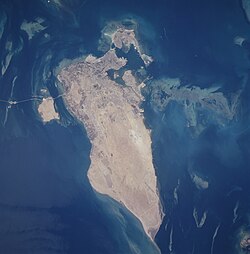
Also not counted are borders on artificial islands such as Passport Island, which is the only land border of Bahrain.
Also has a border with the Dhekelia military base, which is a British Overseas military base between the Republic of Cyprus and the Turkish Northern Republic of Cyprus.
Causeways, bridges, and tunnels
Passport Island, the site of the land border between Bahrain and Saudi Arabia, is seen at the far left. Each nation has a border checkpoint on the island on opposite sides of the border.
Often called fixed crossings or fixed links, transportation corridors constructed to cross bodies of water without any intermittent connections such as ferries or ships may be between different states. These may be considered artificial "persistent" borderpoints for land vehicles or pedestrians, but are not typically considered land borders given their need for continuous operation and maintenance, as well as their ease of volume control or closure by either state. Two countries are islands and have no land borders, but maintain fixed borderpoints with other nations.
A constituent country of the Kingdom of Denmark, Greenland had a border dispute with Canada regarding uninhabited Hans Island. The island is located in the centre of the Kennedy Channel of Nares Strait (between Canada's Ellesmere Island and northern Greenland), which constitutes the agreed maritime border. On June 11, 2022, both countries signed an agreement to split the island, which will come into effect as soon as the parliaments of Canada, Denmark, Greenland, and Nunavut ratify it.[2]
Many countries historically had only one neighbour. Some no longer exist while others now have either no land borders or borders with more than one nation due to border changes.
Canada: bordered only by the United States until 2022, it now shares a short border with the Kingdom of Denmark at Hans Island, with Canada's Nunavut on one side and Denmark's Greenland on the other side.
Kingdom of Denmark: bordered only by Germany (with a causeway connecting it to Sweden) until 2022 (the constituent country of Denmark still only borders Germany), it now shares a short border with Canada at Hans Island, with Canada's Nunavut on one side and Denmark's Greenland on the other side.
Korea: bordered only China for several hundred years before 1860, after which a second international border with Russia appeared (approx. 17km (11mi) long), according to the Convention of Peking. Following the division of Korea in 1945 only North Korea now shares this border.
Venda: another Bantustan, Venda was a true enclave bordering only South Africa and separated narrowly from Zimbabwe by the Madimbo corridor to the north; reincorporated on April 27, 1994.
This page is based on this Wikipedia article Text is available under the CC BY-SA 4.0 license; additional terms may apply. Images, videos and audio are available under their respective licenses.