List of enclaves and exclaves

Last updated

In political geography, an enclave is a piece of land belonging to one country (or region etc.) that is totally surrounded by another country (or region). An exclave is a piece of land that is politically attached to a larger piece but not physically contiguous with it (connected to it) because they are completely separated by a surrounding foreign territory or territories. Many entities are both enclaves and exclaves.

Contents

Enclaves that are also exclaves

Each enclave listed in this section has an administrative level equivalent to that of the one other entity that entirely surrounds it. Each enclave is also a part of a main region; hence, it is an exclave of that region.

National level

Name [1] [2] Area (km2)Exclave ofEnclaved withinCoordinatesNotes
Apipé Islands [3] (4)Flag of Argentina.svg  Argentina (Corrientes ProvinceItuzaingó Department)Flag of Paraguay.svg  Paraguay (Misiones Department – Ayolas District) 27°31′S56°51′W / 27.517°S 56.850°W / -27.517; -56.850 Four adjacent islands (Isla Apipé Grande, Isla Apipé Chico, Isla Los Patos and Isla San Martín) with territorial water borders in the Río Paraná, 39 km east of Isla Entre Rios. Island areas are about 276, 23.8, 11.8 and 3.7 km2, respectively.
Isla Entre Ríos [3] Flag of Argentina.svg  Argentina (Corrientes ProvinceBerón de Astrada Department)Flag of Paraguay.svg  Paraguay (Ñeembucú Department – Cerrito District) 27°25′S57°30′W / 27.417°S 57.500°W / -27.417; -57.500 Uninhabited island with territorial water border in the Río Paraná, 39 km west of Isla Apipé.
Isla Martín García 1.84Flag of Argentina.svg  Argentina (Buenos Aires ProvinceLa Plata Partido)Flag of Uruguay.svg  Uruguay 34°10′47″S58°15′0″W / 34.17972°S 58.25000°W / -34.17972; -58.25000 Territorial water border on the Uruguay side of Río de la Plata. Designated as a nature reserve under the jurisdiction of Argentina in 1973.
Artsvashen Flag of Armenia.svg  Armenia (Gegharkunik Province)Flag of Azerbaijan.svg  Azerbaijan 40°38′N45°30′E / 40.633°N 45.500°E / 40.633; 45.500 Controlled by Azerbaijan since the First Nagorno-Karabakh War in 1992.
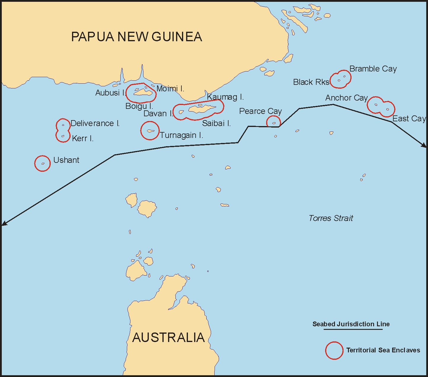
Torres Strait Islands (7)Flag of Australia (converted).svg  Australia (QueenslandShire of Torres and Torres Strait Island Region)Flag of Papua New Guinea.svg  Papua New Guinea 9°25′23″S142°32′10″E / 9.42306°S 142.53611°E / -9.42306; 142.53611 The islands of Anchor Cay, Aubusi Island, Black Rocks, Boigu Island (89.6 km2), Bramble Cay (0.036 km2), Dauan Island (4 km2), Deliverance Island, East Cay, Kaumag Island, Kerr Islet, Moimi Island, Saibai Island (107.9 km2), Turnagain Island (12 km2) and Turu Cay, along with their territorial seas, form seven enclaves within the maritime area of Papua New Guinea under a treaty effective in 1985. The territorial sea of each island does not extend beyond three nautical miles. [4] [5] The mainland of Papua New Guinea is only 6 km from Boigu.
Jungholz 7.05Flag of Austria.svg  Austria (Tyrol state – Reutte District)Flag of Germany.svg  Germany (Bavaria state – Swabia administrative region) 47°34.3′N10°27.3′E / 47.5717°N 10.4550°E / 47.5717; 10.4550 Connected at a quadripoint at the summit of the mountain Sorgschrofen (1636 m); accessible only through Germany. Vinokurov (2007) states, "For all purposes, a connection in a single point does not mean anything. It is just like being completely separated. One cannot pass through a single point, nor is it possible to transport goods. It is not even possible to lay a telephone line." [3]
Barkhudarli Flag of Azerbaijan.svg  Azerbaijan (Qazakh District)Flag of Armenia.svg  Armenia (Tavush Province) 40°59′36″N45°13′31″E / 40.99333°N 45.22528°E / 40.99333; 45.22528 Controlled by Armenia since the First Nagorno-Karabakh War in May 1992; west-southwest of the town of Qazax.
Yukhari Askipara 41°03′58″N45°01′24″E / 41.06611°N 45.02333°E / 41.06611; 45.02333 A destroyed village controlled by Armenia since the First Nagorno-Karabakh War in May 1992; west of the town of Qazax.
Karki / Tigranashen 8Flag of Azerbaijan.svg  Azerbaijan (Nakhchivan Autonomous Republic, Sadarak District)Flag of Armenia.svg  Armenia (Ararat Province) 39°47.3′N44°57′E / 39.7883°N 44.950°E / 39.7883; 44.950 Controlled by Armenia since the First Nagorno-Karabakh War in May 1992; north of Azerbaijan's exclave of Nakhchivan.
Yaradullu (north and south)Flag of Azerbaijan.svg  Azerbaijan (Ağstafa District)Flag of Armenia.svg  Armenia (Tavush Province) 41°00′51.8″N45°26′12.2″E / 41.014389°N 45.436722°E / 41.014389; 45.436722 Two farmland enclaves just across the border from the village of Yaradullu [6] [7] (55 m at the closest point). They are 750 m and 1500 m southwest of the municipality of Tatlı on the west bank of the Akhum River; approximately 300x400 m and 300x200 m. The surrounding Armenian territory has been occupied by Azerbaijan since the First Nagorno-Karabakh War in May 1992, so that these two small pockets of land are de facto no longer exclaves.
Dahagram-Angarpota 25.95Flag of Bangladesh.svg  Bangladesh (Rangpur DivisionLalmonirhat district)Flag of India.svg  India (West Bengal state – Cooch Behar district) 26°18′N88°57′E / 26.300°N 88.950°E / 26.300; 88.950 Dahagram–Angarpota is a composite enclave of two adjoining chhits. It is separated from the contiguous area of Bangladesh at its closest point by 178 metres (584 ft). The enclave has an estimated population of 20,000. After the exchange of enclaves with India under the Land Boundary Agreement on 31 July 2015, Bangladesh retained it as an exclave. The Tin Bigha Corridor, a strip of Indian territory 85 metres (279 ft) wide running from the enclave to the Bangladesh mainland at its nearest approach, was leased to Bangladesh for 999 years for access to the enclave. [1] [8] [9]
Baarle-Hertog (22 parcels)2.3448Flag of Belgium (civil).svg  Belgium (Antwerp province – Baarle-Hertog municipality)Flag of the Netherlands.svg  Netherlands (North Brabant province – Baarle-Nassau municipality) 51°26′13″N4°55′43″E / 51.43694°N 4.92861°E / 51.43694; 4.92861 (H1)A group of 22 Belgian enclaves in the southern Netherlands. Enclaves H1 and H2 are connected at a single point.
Međurečje 3.9584Flag of Bosnia and Herzegovina.svg  Bosnia and Herzegovina (Republika SrpskaRudo municipality)Flag of Serbia.svg  Serbia (Zlatibor DistrictPriboj municipality) 43°33′30″N19°25′30″E / 43.55833°N 19.42500°E / 43.55833; 19.42500 Homeland of Bosnia-Herzegovina is 1,130 metres (3,710 ft) to the north. Sastavci is the name of the neighbouring village in Serbia.
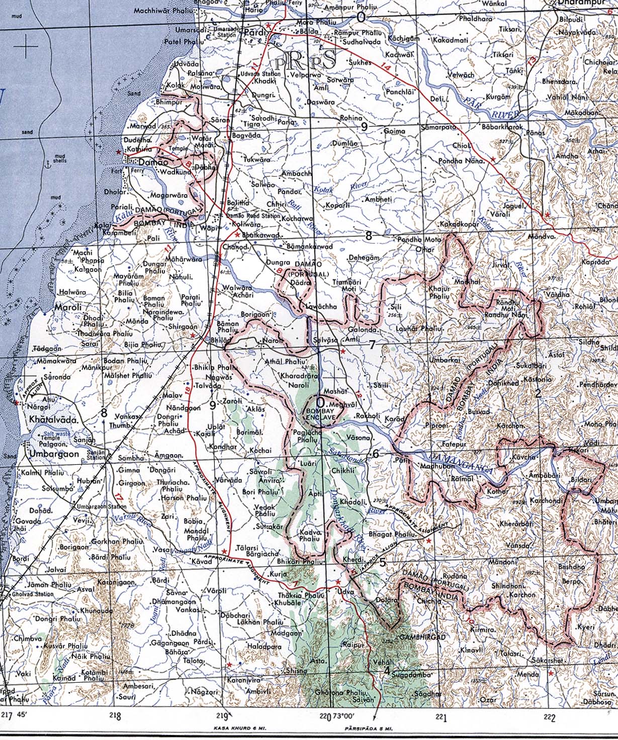
West Kowloon Port (aka. Mainland Port Area)0.11Flag of the People's Republic of China.svg  China (Guangdong province – Futian district)Flag of Hong Kong.svg  Hong Kong (Yau Tsim Mong district) 22°18′14″N114°09′54″E / 22.304°N 114.165°E / 22.304; 114.165 China's immigration/customs border crossing that is located within Hong Kong; compartments of operating passenger trains on the rail link in Hong Kong are also considered part of Mainland Port Area. [10] It is not contiguous with the rest of China. Effectively ceded to China in 2018 for a token HK$1,000 per year.
Quitasueño 3,577, including water area [11] Flag of Colombia.svg  Colombia (San Andrés y Providencia Department)Flag of Nicaragua.svg  Nicaragua 14°24′1″N81°7′47″W / 14.40028°N 81.12972°W / 14.40028; -81.12972 [12] (QS32) [11] On 19 November 2012, the International Court of Justice upheld Colombia's claim to Quitasueño, plus a 12-NM territorial zone, and re-defined Nicaragua's exclusive economic zone (EEZ), thus surrounding the island bank. [13] It deemed one of the bank's 54 features to be an island at high tide (elevation 70 cm, area 1 m2) [14] and created enclaves as an equitable solution. [15] The area of the bank, excluding the 12-mile zone, is ~290 km2. [16]
Serrana 14°17′13″N80°21′48″W / 14.28694°N 80.36333°W / 14.28694; -80.36333 (Southwest Cay)On 19 November 2012, ICJ upheld Colombia's claim to Serrana, plus a 12-NM territorial zone, and re-defined Nicaragua's EEZ, surrounding the island bank. [13] The land area is ~0.11 km2, and the area of the bank, excluding the 12-mile zone, is ~322 km2. [16] Colombia decried the loss of maritime areas and creation of "'enclaves' around Quitasueño and Serrana that could restrict" access. [13]
Brezovica Žumberačka (2)0.0183+Flag of Croatia.svg  Croatia (Karlovac CountyOzalj town)Flag of Slovenia.svg  Slovenia (Metlika municipality) 45°41′22″N15°18′12″E / 45.68944°N 15.30333°E / 45.68944; 15.30333 The first enclave contains four dwellings surrounded by agricultural land near the Slovenian village of Brezovica pri Metliki. It is about 437 m long and 60 m wide covering 1.83 ha. Confirmed by both Croatian and Slovenian cadaster maps, it lies about 100 metres away from the main border at the closest point. [6] [7] [17] [18]

A second enclave lies within 300 metres of the first. It was created on 29 June 2017 when the Permanent Court of Arbitration decided that a disputed 2.4 ha parcel is part of Slovenia and that the border follows Slovenian cadastral limits, thus completing the encirclement of the second Croatian enclave. [19] [20] Croatia has stated that it will ignore the arbitration decision. [21]

Ormidhia 1.694Flag of Cyprus.svg  Cyprus (Larnaca District)Flag of the United Kingdom.svg  Dhekelia Sovereign Base Area 34°59′33″N33°46′49″E / 34.99250°N 33.78028°E / 34.99250; 33.78028 Small exclave surrounded by Dhekelia, a British Overseas Territory in southeastern Cyprus. The degree of sovereignty and legitimacy of the Sovereign Base Areas is disputed by the Republic of Cyprus. [22] [23]
Xylotymbou 0.947 35°01′03″N33°44′37″E / 35.01750°N 33.74361°E / 35.01750; 33.74361 Small exclave surrounded by Dhekelia, a British Overseas Territory.
"Electricity Authority of Cyprus" Refugee Settlement 34°59′04″N33°44′37″E / 34.98444°N 33.74361°E / 34.98444; 33.74361 North of Dhekelia Power Station from which it is separated by a British road; the closest point between the two territories is 21 metres.
Dhekelia Power Station 34°58′49″N33°44′45″E / 34.98028°N 33.74583°E / 34.98028; 33.74583 Partially borders the coast but enclosed by UK land and waters disputed between Cyprus and the UK; the power station is owned by the Electricity Authority of Cyprus (EAC); no permanent population.
Münsterbildchen 1.826Flag of Germany.svg  Germany (North Rhine-Westphalia state – Aachen district – Roetgen municipality)Flag of Belgium (civil).svg  Belgium (Liège province – Raeren municipality) 50°39′36″N6°11′24″E / 50.66000°N 6.19000°E / 50.66000; 6.19000 West of Vennbahn trackbed; northernmost German enclave, mainly home to industrial and warehouse structures.
Roetgener Wald  [ de ]9.98Flag of Germany.svg  Germany (North Rhine-Westphalia state – Aachen district – Roetgen and Simmerath municipalities)Flag of Belgium (civil).svg  Belgium (Liège province) 50°38′12″N6°14′32″E / 50.63667°N 6.24222°E / 50.63667; 6.24222 Western part of Lammersdorf  [ de ], southern part of Roetgen, and intervening forest (Forst Rötgen); west and south of Vennbahn trackbed. From 1922 to 1958, the center portion (between Grenzweg and a boundary with three turning points west of the Schleebach stream) was Belgian territory. Until 1949, the east–west road that connected the two outer (German) portions was also German territory; therefore, the German land formed one oddly-shaped enclave (that also included the road to Konzen). In 1949, it was split into two enclaves when Germany ceded the roads to Belgium; [24] in 1958, Belgium returned the east–west road and also ceded the centre section of the current enclave to Germany.
Rückschlag  [ de ]0.016Flag of Germany.svg  Germany (North Rhine-Westphalia state – Aachen district – Monschau town)Flag of Belgium (civil).svg  Belgium (Liège province – Eupen municipality) 50°35′52″N6°14′53″E / 50.59778°N 6.24806°E / 50.59778; 6.24806 Part of city of Monschau, west of Vennbahn trackbed; smallest German exclave, consisting of a house and a garden.
Mützenich 12.117Flag of Belgium (civil).svg  Belgium (Liège province) 50°33′54″N6°13′5″E / 50.56500°N 6.21806°E / 50.56500; 6.21806 West of Belgium's Vennbahn trackbed.
Ruitzhof  [ de ]0.937 50°31′29″N6°11′39″E / 50.52472°N 6.19417°E / 50.52472; 6.19417 Part of city of Monschau, west of Vennbahn trackbed; southernmost Vennbahn enclave after 1949 (when Belgium annexed the Hemmeres  [ de ] enclave).
Büsingen am Hochrhein 7.62Flag of Germany.svg  Germany (Baden-Württemberg state – Konstanz district)Flag of Switzerland (Pantone).svg   Switzerland 47°42′N8°42′E / 47.700°N 8.700°E / 47.700; 8.700 At its closest, less than 700 metres (2,300 ft) from Germany proper (to the east). Part of Swiss customs
Campione d'Italia 1.6Flag of Italy.svg  Italy (Lombardy region – Province of Como)Flag of Switzerland (Pantone).svg   Switzerland (Canton TicinoLugano District) 45°58′10″N8°58′25″E / 45.96944°N 8.97361°E / 45.96944; 8.97361 Uses the Swiss franc, Former part of Swiss customs (until 2020). Separated by less than 1 km, at the shortest distance, from the rest of Italy by Lake Lugano and mountains, but the terrain requires a 14 km road journey to reach the nearest Italian town, Lanzo d'Intelvi.
Barak (de facto)2.07 [25] Flag of Kyrgyzstan (2023).svg  Kyrgyzstan (Kara-Suu DistrictOsh Region)Flag of Uzbekistan.svg  Uzbekistan (Andijan Region) 40°40′N72°46′E / 40.667°N 72.767°E / 40.667; 72.767 Kyrgyzstan's 1991 pre-independence border is the de jure international border, but much of it is hotly disputed with its neighbors. In August 1999, the area around Barak was occupied by Uzbekistan, cutting it off from Kyrgyz territory. Uzbek forces dug up and blockaded the road to Ak-Tash [26] while also allegedly seizing large areas of Kyrgyz land that had been loaned in the Soviet era but never returned. [27] They entrenched themselves within much of Kyrgyz border territory and refused to leave. [28] Barak became a de facto enclave only 1.5 km from the shifted main border. [29] Four Uzbek enclaves and Barak are major sticking points in delimitation talks, [30] and disputes have centered on the areas of Barak, Sokh, Gava and Gavasay (stream). [31] (Map) In August 2018 Kyrgyz and Uzbek authorities agreed to a land swap that would eliminate the exclave. The exchange process may take up to two years. [32]
Likoma Island 130.0 (incl a territorial water area)Flag of Malawi.svg  Malawi (Northern RegionLikoma District)Flag of Mozambique.svg  Mozambique (Niassa ProvinceLago District) 12°04′S34°44′E / 12.067°S 34.733°E / -12.067; 34.733 Lacustrine enclave, including smaller islets, with territorial water border in Lake Malawi (Lake Nyasa); only ~5 kilometres from the Mozambique shore; combined land area of Likoma Is. and the smaller Chizumulu Is. is 18 km2.
Chizumulu Island (incl Lundu Is., Papia Is., Ngkyvo Is.)101.4 (incl 2-NM territorial water area) 12°01′0″S34°37′14″E / 12.01667°S 34.62056°E / -12.01667; 34.62056 Lacustrine enclave with territorial water border in Lake Malawi (Lake Nyasa); Malawian mainland is 46 km away.
Baarle-Nassau (8 parcels)0.150684Flag of the Netherlands.svg  Netherlands (North Brabant province – Baarle-Nassau municipality)Flag of Belgium (civil).svg  Belgium (Antwerp province – Baarle-Hertog municipality) 51°24′43″N4°52′16″E / 51.41194°N 4.87111°E / 51.41194; 4.87111 (N8)Seven of the eight Dutch enclaves are counter-enclaves inside two Belgian enclaves (H1 and H8); one is in the main body of Belgium (N8).
Laguna Los Portillos and beachFlag of Nicaragua.svg  Nicaragua (Río San Juan Department)Flag of Costa Rica.svg  Costa Rica (Limón Province) 10°55′55.1″N83°40′12.4″W / 10.931972°N 83.670111°W / 10.931972; -83.670111 On 2 Feb 2018, the ICJ rendered a decision in a border dispute between Nicaragua and Costa Rica regarding Isla Portillos  [ es ]. Nicaragua was left with just the Laguna Los Portillos and its short strip of beach. The court also decided that the sea just outside of the lagoon would be Costa Rican waters. The ICJ concluded that the whole beach is Costa Rican except for the part directly between the lagoon and the Caribbean Sea – now a tiny enclave of Nicaraguan territory separated from the rest of the country. [33]
Madha Flag of Oman.svg  Oman (Musandam Governorate)Flag of the United Arab Emirates.svg  United Arab Emirates 25°17′N56°17′E / 25.283°N 56.283°E / 25.283; 56.283 Halfway between the Omani fragment on the Musandam Peninsula and the rest of Oman; surrounds the UAE counter-enclave of Nahwa.
San'kovo-Medvezh'e 4.54Flag of Russia.svg  Russia (Bryansk OblastZlynkovsky District)Flag of Belarus.svg  Belarus (Gomel RegionDobrush Raion) 52°28′48″N31°33′51″E / 52.48000°N 31.56417°E / 52.48000; 31.56417 Contains two small villages that have been depopulated since the 1986 Chernobyl disaster in Ukraine.
Llívia 12.84Flag of Spain.svg  Spain (Catalonia autonomous community – Province of Girona/Cerdanya comarca)Flag of France.svg  France (Occitania region – Pyrénées-Orientales department) 42°28′N1°59′E / 42.467°N 1.983°E / 42.467; 1.983 To the east of Andorra, separated from the rest of Spain by a corridor about 2 km wide containing the French communes of Ur and Bourg-Madame.
Vorukh Flag of Tajikistan.svg  Tajikistan (Sughd ProvinceIsfara District)Flag of Kyrgyzstan (2023).svg  Kyrgyzstan (Batken ProvinceBatken District) 39°51′04″N70°38′00″E / 39.85111°N 70.63333°E / 39.85111; 70.63333 South of the mountain Ak-Tash; population is 95% Tajik and the rest Kyrgyz.
"Lolazor"Flag of Kyrgyzstan (2023).svg  Kyrgyzstan (Batken ProvinceLeilek District) 40°04′05″N69°32′41″E / 40.06806°N 69.54472°E / 40.06806; 69.54472 Near the railway station of Stantsiya Kayragach, next to the Kyrgyz–Tajik border; also referred to as "Western Qal'acha" due to proximity to the Tajik town of Qal'acha; apparently there is no named settlement.
Sarvan (also Sarvaksoi, Sarvaki-bolo)8.4Flag of Tajikistan.svg  Tajikistan (Sughd RegionAsht District)Flag of Uzbekistan.svg  Uzbekistan (Namangan Region – Pop district) 40°58′00″N70°36′56″E / 40.96667°N 70.61556°E / 40.96667; 70.61556 Long, narrow territory located in the Fergana and Isfara valleys region where Kyrgyzstan, Tajikistan and Uzbekistan meet.
Nahwa Flag of the United Arab Emirates.svg  United Arab Emirates (Sharjah emirate)Flag of Oman.svg  Oman (Musandam Governorate) 25°16′N56°16′E / 25.267°N 56.267°E / 25.267; 56.267 A counter-enclave surrounded by Madha, reported to consist of around forty houses. [34]
Filomena Islands  [ es ] (5 islands)Flag of Uruguay.svg  Uruguay (Río Negro Department)Flag of Argentina.svg  Argentina (Entre Ríos ProvinceGualeguaychú and Uruguay departments) 32°59′S58°6′W / 32.983°S 58.100°W / -32.983; -58.100 Five adjacent islands (Isla Filomena Grande, Isla Filomena Chica, Isla Palma Chica, Isla Bassi, Isla Tres Cruces) with territorial water borders in the Uruguay River. Uninhabited islands that form part of the Esteros de Farrapos National Park.
Sokh Flag of Uzbekistan.svg  Uzbekistan (Fergana Region – Sokh district)Flag of Kyrgyzstan (2023).svg  Kyrgyzstan (Batken Region) 40°02′39″N71°05′39″E / 40.04417°N 71.09417°E / 40.04417; 71.09417 Large enclave with 99% Tajik population, the rest Kyrgyz and almost no ethnic Uzbeks.
Chon-Qora or Qalacha (the 2 Uzbek villages in the enclave) 40°14′37″N71°02′14″E / 40.24361°N 71.03722°E / 40.24361; 71.03722 Tiny enclave lying on the Sokh River, immediately north of Sokh; measures about 3 km long by 1 km wide, with the Uzbek villages of Chon-Qora (or Chongara 40°15′03″N71°02′15″E / 40.25083°N 71.03750°E / 40.25083; 71.03750 ) and Qalacha ( 40°14′10″N71°02′12″E / 40.23611°N 71.03667°E / 40.23611; 71.03667 ) at either end; the Kyrgyz village of Chong-Kara (or Chon-Kara 40°15′37″N71°00′41″E / 40.26028°N 71.01139°E / 40.26028; 71.01139 ) lies 2 km northwest. [6] [7] [35] [Note: The Kyrgyz Cyrillic alphabet contains three characters not present in the Uzbek alphabet. One of these characters is romanised from Kyrgyz as the digraph ng, which is not present in romanised Uzbek words.] [36]
Jani-Ayil (also Jangy-ayyl or Khalmion)Flag of Uzbekistan.svg  Uzbekistan (Fergana Region – Fergana district)Flag of Kyrgyzstan (2023).svg  Kyrgyzstan (Batken RegionKadamjay District) 40°12′09″N71°39′58″E / 40.20250°N 71.66611°E / 40.20250; 71.66611 Tiny enclave north-northwest of the Shakhimardan enclave; within 1 km of the Uzbek main border; the Kyrgyz towns of Jangy-Ayyl ( 40°10′56″N71°40′49″E / 40.18222°N 71.68028°E / 40.18222; 71.68028 ) and Khalmion ( 40°12′44″N71°37′58″E / 40.21222°N 71.63278°E / 40.21222; 71.63278 ) lie outside opposite edges of this enclave. [6] [7] [35]
Shakhimardan 39°58′59″N71°48′18″E / 39.98306°N 71.80500°E / 39.98306; 71.80500 Located in a narrow valley in the Alay Mountains where the rivers Ok-su and Kok-su meet to form the Shakhimardan-sai  [ ru ]. [6] [7] [35]
High Seas Flag of the United Nations.svg  International waters Flag of Japan.svg  Japan 26°19′N135°52′E / 26.317°N 135.867°E / 26.317; 135.867 Surrounded by Japan's EEZ; it lies between the territorial zones of Honshu, Shikoku, the Bonin Islands, Okino-tori-shima and Okinawa Island
High Seas Flag of the United Nations.svg  International waters Flag of New Zealand.svg  New Zealand 44°19′S178°12′E / 44.317°S 178.200°E / -44.317; 178.200 Surrounded by New Zealand's EEZ; it lies between the territorial zones of the Chatham Islands, North Island and the Bounty Islands
High Seas Flag of the United Nations.svg  International waters Flag of New Zealand.svg  New Zealand 49°32′S173°6′E / 49.533°S 173.100°E / -49.533; 173.100 Surrounded by New Zealand's EEZ; it lies between the territorial zones of Campbell Island, South Island and the Antipodes Islands
High Seas Flag of the United Nations.svg  International waters Flag of French Polynesia.svg  French Polynesia 24°12′S143°18′W / 24.2°S 143.3°W / -24.2; -143.3 Surrounded by France's EEZ; it lies between the territorial zones of the Bass Islands, Raivavae, Nukutepipi, and Tematagi

First-order subnational level

NameArea (km2)Parent CountryExclave ofEnclaved withinCoordinatesNotes
Qobu Flag of Azerbaijan.svg  Azerbaijan Absheron Rayon Baku 40°24′N49°42′E / 40.400°N 49.700°E / 40.400; 49.700 Map showing Absheron rayon and Qobu; another showing Çeyildağ also
(south of Şərədil)Flag of Azerbaijan.svg  Azerbaijan Agsu District Shamakhi District 40°35.8′N48°29′E / 40.5967°N 48.483°E / 40.5967; 48.483
Çeyildağ [37] Flag of Azerbaijan.svg  Azerbaijan Baku Absheron Rayon 40°16′57″N49°16′45″E / 40.28250°N 49.27917°E / 40.28250; 49.27917 Çeyildağ at GEOnet Names Server
  Divanalılar and  Yuxarı Veysəlli [38] [39] [40] Flag of Azerbaijan.svg  Azerbaijan Füzuli Rayon Xocavənd Rayon 39°41′32.03″N47°2′11.83″E / 39.6922306°N 47.0366194°E / 39.6922306; 47.0366194 , 39°44′24.6″N47°5′22.6″E / 39.740167°N 47.089611°E / 39.740167; 47.089611 (Yuxarı Veysəlli at GEOnet Names Server)
Yuxarı Məzrə Flag of Azerbaijan.svg  Azerbaijan Jabrayil District Khojavend District 39°27.5′N46°57.4′E / 39.4583°N 46.9567°E / 39.4583; 46.9567
  Yeni Qaralar and (near Muğanlı)Flag of Azerbaijan.svg  Azerbaijan Khojaly District Aghdam District 40°2′9″N46°45′37″E / 40.03583°N 46.76028°E / 40.03583; 46.76028 ,
39°55.9′N46°57.5′E / 39.9317°N 46.9583°E / 39.9317; 46.9583
Ağbaş Flag of Azerbaijan.svg  Azerbaijan Shabran District Siyazan District 41°6.8′N49°5.7′E / 41.1133°N 49.0950°E / 41.1133; 49.0950
de jure
 (includes Aşağı Quşçular, Yuxarı Quşçular, Malıbəyli) [40] [41] and (southeast of Khojaly)
Flag of Azerbaijan.svg  Azerbaijan Şuşa Rayon Xocalı Rayon 39°49′52.7″N46°48′7.2″E / 39.831306°N 46.802000°E / 39.831306; 46.802000 ,
39°52.5′N46°47.9′E / 39.8750°N 46.7983°E / 39.8750; 46.7983
Located near Xankəndi (Stepanakert), which includes parts of Şuşa and Xocalı Rayons. (Aşağı Quşçular at GEOnet Names Server, Yuxarı Quşçular at GEOnet Names Server, Malıbəyli at GEOnet Names Server)
 (northeast of Deşdahat, north of Başarat) [40] [42] Flag of Azerbaijan.svg  Azerbaijan Xocavənd Rayon Qubadlı Rayon 39°31′40″N46°43′54″E / 39.52778°N 46.73167°E / 39.52778; 46.73167 Map showing exclave.
 (main part of the city)
  Minsk National Airport
  Sokol  [ be ]
409.5Flag of Belarus.svg  Belarus Minsk Minsk Region (Minsk and Smalyavichy Raions) 53°54′N27°34′E / 53.900°N 27.567°E / 53.900; 27.567 , 53°53.5′N28°2.8′E / 53.8917°N 28.0467°E / 53.8917; 28.0467 , 53°52.6′N27°53.9′E / 53.8767°N 27.8983°E / 53.8767; 27.8983
 (1 parcel)Flag of Belarus.svg  Belarus Minsk Region (Minsk Raion) Minsk (Maskowski District) 53°50′24″N27°28′17″E / 53.84000°N 27.47139°E / 53.84000; 27.47139
(south of Arjo village)Flag of Ethiopia.svg  Ethiopia Benishangul-Gumuz Region (Kamashi ZoneBelo Jegonfoy) Oromia Region 8°58.6′N36°12.8′E / 8.9767°N 36.2133°E / 8.9767; 36.2133
(northeast of Uke) (2 parcels)Flag of Ethiopia.svg  Ethiopia Oromia Region (East Welega ZoneGuto Gida district) 9°23.2′N36°33.5′E / 9.3867°N 36.5583°E / 9.3867; 36.5583 , 9°24.2′N36°36.2′E / 9.4033°N 36.6033°E / 9.4033; 36.6033
 (includes Gardères, Luquet) and (includes Séron, Escaunets, Villenave-près-Béarn)42.02Flag of France.svg  France Occitania (Hautes-PyrénéesArrondissement of TarbesCanton of Ossun and Canton of Vic-en-Bigorre) Nouvelle-Aquitaine (Pyrénées-AtlantiquesArrondissement of Pau) 43°16′N0°7′W / 43.267°N 0.117°W / 43.267; -0.117 , 43°20′N0°5′W / 43.333°N 0.083°W / 43.333; -0.083 Séron is less than 300 metres from the neighbouring enclave to its south that includes Gardères and Luquet; they, along with Séron, are part of Canton d'Ossun. Escaunets and Villenave-près-Béarn are in the same enclave with Séron, but unlike Séron, they are part of Canton de Vic-en-Bigorre.
Canton of Valréas 124.91Flag of France.svg  France Provence-Alpes-Côte d'Azur (VaucluseArrondissement of Avignon) Auvergne-Rhône-Alpes (DrômeArrondissement of Nyons) 44°21′N4°58′E / 44.350°N 4.967°E / 44.350; 4.967 Known as the Enclave des Papes, it was part of the possessions of the Pope in France near Avignon; [43] it was attached to Vaucluse when annexed after the départements were created (see Comtat Venaissin).
(2 parcels)Flag of Germany.svg  Germany Baden-Württemberg (KarlsruheRhein-Neckar-KreisLaudenbach) Hesse (DarmstadtBergstraßeHeppenheim) 49°37′08.8″N8°40′58.3″E / 49.619111°N 8.682861°E / 49.619111; 8.682861
49°36′31.9″N8°40′44.5″E / 49.608861°N 8.679028°E / 49.608861; 8.679028
One of these is a counter enclave.
 Hansestadt Bremen (south) and Hansestadt Bremen (north)408Flag of Germany.svg  Germany Freie Hansestadt Bremen Lower Saxony 53°7′N8°45′E / 53.117°N 8.750°E / 53.117; 8.750 53°34.5′N8°34′E / 53.5750°N 8.567°E / 53.5750; 8.567 Bremerhaven and Überseehafengebiet comprise Bremen's northern part, which is 60 km downstream of Bremen's larger southern part on the River Weser. Both parts of Hansestadt Bremen are enclaves within Lower Saxony, as well as exclaves of each other.
Fehrmoor (part)Flag of Germany.svg  Germany Freie Hansestadt Bremen (Bremerhaven  Stadt – Nord StadtbezirkLeherheide  [ de ] Stadtteil – Fehrmoor Ortsteil) Lower Saxony (Cuxhaven) 53°36.4′N8°39.1′E / 53.6067°N 8.6517°E / 53.6067; 8.6517 Fehrmoor is a part of Leherheide, which is a sub-division of Bremerhaven. Part of Fehrmoor is separated by a narrow strip of Lower Saxony from the rest of Bremerhaven, making it an exclave of the city and of the state.
Ober-Laudenbach (part)Flag of Germany.svg  Germany Hesse (DarmstadtBergstraßeHeppenheim) Baden-Württemberg (KarlsruheRhein-Neckar-KreisLaudenbach) 49°37′02.3″N8°40′39.6″E / 49.617306°N 8.677667°E / 49.617306; 8.677667 Contains a counter enclave.
Choto Pokalagi0.549Flag of India.svg  India Assam (Dhubri district) West Bengal (Cooch Behar district) 26°18.5′N89°44.1′E / 26.3083°N 89.7350°E / 26.3083; 89.7350 A national level enclave prior to the incorporation of Cooch Behar into India in 1949
Gobrarkuthi0.149Flag of India.svg  India 26°14.5′N89°42.5′E / 26.2417°N 89.7083°E / 26.2417; 89.7083 A national level enclave prior to the incorporation of Cooch Behar into India in 1949
Ramrayerkuthi0.084Flag of India.svg  India 26°9.7′N89°42.4′E / 26.1617°N 89.7067°E / 26.1617; 89.7067 A national level enclave prior to the incorporation of Cooch Behar into India in 1949
Dadra Flag of India.svg  India Dadra and Nagar Haveli and Daman and Diu (Dadra and Nagar Haveli district) Gujarat (Valsad district) 20°19′N72°58′E / 20.317°N 72.967°E / 20.317; 72.967 Dadra was part of the former Portuguese India.
Maghval [44] [45] Flag of India.svg  India Gujarat (Valsad districtKaparada Taluka) Dadra and Nagar Haveli and Daman and Diu (Dadra and Nagar Haveli district – Nagar Haveli taluka) 20°13′N73°2′E / 20.217°N 73.033°E / 20.217; 73.033 Formerly "Bombay Enclave," Maghval was a British counter-enclave within the Portuguese enclave within British India until independence.
Yanam district 20Flag of India.svg  India Puducherry Andhra Pradesh (East Godavari district) 16°43′N82°16′E / 16.717°N 82.267°E / 16.717; 82.267 The four districts of Puducherry (Pondicherry, Mahe, Yanam and Karaikal) constituted a French colony until 1954.
  Cherukallayi and (includes Palloor, Chalakkara, Pandakkal)Flag of India.svg  India Puducherry (Mahe district) Kerala (Kannur district) 11°42′44″N75°32′1″E / 11.71222°N 75.53361°E / 11.71222; 75.53361 , 11°44′N75°32.5′E / 11.733°N 75.5417°E / 11.733; 75.5417 Mahe district consists of these two true enclaves and Mahé municipality.
  Bahour PS- Karaiyambuthur OP (3 enclaves), •  Dhanvantry Nagar PS- Alankuppam OP, •  Thirubuvanai PS/ Thirukkanur PS (part), •  Kattery Kuppam PS/ Thirukkanur PS (part), •  Nettapakkam PS (west), •  Mangalam PS (part), •  Thirukkanur PS (part) [46] Flag of India.svg  India Puducherry (Pondicherry district) Tamil Nadu (Cuddalore and Viluppuram districts) 11°57′N79°38′E / 11.950°N 79.633°E / 11.950; 79.633 (the largest part)These 9 parcels along with three coastal pene-exclaves comprise all of Pondicherry district.
Kilinjikuppam and Singirikudi (part)Flag of India.svg  India Tamil Nadu (Cuddalore districtCuddalore taluk) Puducherry (Pondicherry district) 11°53.3′N79°47.3′E / 11.8883°N 79.7883°E / 11.8883; 79.7883 This enclave is surrounded by one of the three coastal pene-exclaves in Pondicherry district.
Bara Lowkuthi5.47Flag of India.svg  India West Bengal (Cooch Behar district) Assam (Kokrajhar district) 26°20.5′N89°48′E / 26.3417°N 89.800°E / 26.3417; 89.800 A national level enclave prior to the incorporation of Cooch Behar into India in 1949
Ca' Raffaello  [ it ] (includes Santa Sofia Marecchia and Ortale)Flag of Italy.svg  Italy Tuscany (Province of ArezzoBadia Tedalda) Emilia-Romagna (Province of Rimini) 43°47.4′N12°12.2′E / 43.7900°N 12.2033°E / 43.7900; 12.2033 One enclave
Monte Ruperto  [ it ]2.7Flag of Italy.svg  Italy Umbria (Province of PerugiaCittà di Castello) Marche (Province of Pesaro and Urbino) 43°36.1′N12°25.4′E / 43.6017°N 12.4233°E / 43.6017; 12.4233 This enclave consists of hills, cropland and few structures.
Lama Superiore and Valle InferioreFlag of Italy.svg  Italy Emilia Romagna (Province of PiacenzaCorte Brugnatella) Lombardy (Province of Pavia) 44°42′12″N9°17′42″E / 44.70344°N 9.29495°E / 44.70344; 9.29495 , 44°41′37″N9°18′07″E / 44.69374°N 9.30190°E / 44.69374; 9.30190 Two tiny rural enclaves very close to each other. There is just one house in Valle Inferiore and none in Lama.
San Pellegrino in Alpe  [ it ]Flag of Italy.svg  Italy Emilia Romagna (Province of ModenaFrassinoro) Tuscany (Province of LuccaCastiglione di Garfagnana) 44°11′24″N10°28′51″E / 44.18990°N 10.48074°E / 44.18990; 10.48074 Enclave including part of the village of San Pellegrino in Alpe. map
San Pio (1 parcel)Flag of Italy.svg  Italy Lombardy (Province of PaviaPieve del Cairo) Piedmont (Province of Alessandria) 45°01′07″N8°48′47″E / 45.018488°N 8.813027°E / 45.018488; 8.813027 The enclave is a small plot of cropland
IesceFlag of Italy.svg  Italy Basilicata (Province of MateraMatera) Apulia (Province of BariAltamura) 40°45′20″N16°38′27″E / 40.7556°N 16.6407°E / 40.7556; 16.6407 The enclave is a small plot of cropland
(1 parcel)Flag of Japan.svg  Japan Saitama Prefecture (Fukaya) Gunma Prefecture (Isesaki) 36°14′40″N139°15′46″E / 36.2444°N 139.2628°E / 36.2444; 139.2628
(2 parcels)Flag of Japan.svg  Japan Tokyo (Machida) Kanagawa Prefecture (Sagamihara) 35°35′56″N139°21′23″E / 35.5989°N 139.3565°E / 35.5989; 139.3565
35°35′54″N139°21′49″E / 35.5984°N 139.3637°E / 35.5984; 139.3637
Nishiōizumimachi 0.002Flag of Japan.svg  Japan Tokyo (Nerima Ward) Saitama Prefecture (Niiza) 35°45′48″N139°34′01″E / 35.7634°N 139.5669°E / 35.7634; 139.5669 The enclave is a small street. [47]
WesFlag of Liechtenstein.svg  Liechtenstein Planken Schaan 47°11′3″N9°32′1″E / 47.18417°N 9.53361°E / 47.18417; 9.53361 One of the 4 exclaves of Planken (map)
BrunneneggFlag of Liechtenstein.svg  Liechtenstein Schaan Planken 47°10′44″N9°33′1″E / 47.17889°N 9.55028°E / 47.17889; 9.55028 One of the 4 exclaves of Schaan (map)
RüttisteinFlag of Liechtenstein.svg  Liechtenstein Vaduz Planken 47°11′13″N9°33′2″E / 47.18694°N 9.55056°E / 47.18694; 9.55056 One of the 6 exclaves of Vaduz (map)
ForstFlag of Liechtenstein.svg  Liechtenstein Vaduz Schaan 47°10′34″N9°31′34″E / 47.17611°N 9.52611°E / 47.17611; 9.52611 One of the 6 exclaves of Vaduz (map)
(2 parcels)Flag of Moldova.svg  Moldova Dubăsari District Transnistrian-controlled Dubăsari District 47°20.2′N29°12.5′E / 47.3367°N 29.2083°E / 47.3367; 29.2083 , 47°22′9″N29°17′42″E / 47.36917°N 29.29500°E / 47.36917; 29.29500 Transnistria is de facto independent, but not recognised by any member states of the United Nations. Control of two highways (east of Roghi, west of Vasilievca) by Transnistria in this frozen conflict created these two neighbouring enclaves.
Condrița Flag of Moldova.svg  Moldova Chișinău municipality Strășeni District (Scoreni commune) 47°03′20.4″N28°34′13.6″E / 47.055667°N 28.570444°E / 47.055667; 28.570444
Văduleni  [ ro ]Flag of Moldova.svg  Moldova Chișinău municipality Criuleni district 47°4′12″N29°4′53″E / 47.07000°N 29.08139°E / 47.07000; 29.08139
Flag of Moldova.svg  Moldova Călărași District (Bahmut commune) Ungheni District (Hîrcești commune) 47°20′21″N28°6′44″E / 47.33917°N 28.11222°E / 47.33917; 28.11222
Flag of Moldova.svg  Moldova Ocnița District (Unguri commune) Dondușeni District 48°20′13″N27°45′40″E / 48.33694°N 27.76111°E / 48.33694; 27.76111
Flag of Moldova.svg  Moldova Călărași District (Vărzăreștii Noi commune) Strășeni District 47°11′10″N28°28′58″E / 47.18611°N 28.48278°E / 47.18611; 28.48278
Flag of Moldova.svg  Moldova Orhei District (Peresecina commune) Criuleni District 47°11′33″N28°51′01″E / 47.19250°N 28.85028°E / 47.19250; 28.85028
Central Ulaanbaatar3944Flag of Mongolia.svg  Mongolia Ulaanbaatar Töv Province 47°57′N107°0′E / 47.950°N 107.000°E / 47.950; 107.000 Ulaanbaatar is divided into three sections, of which two are enclaves
Bagakhangai 140 47°21′N107°29′E / 47.350°N 107.483°E / 47.350; 107.483
Sambú 1296.4Flag of Panama.svg  Panama Comarca Emberá-Wounaan Darién Province (Chepigana District) 7°51′N78°8′W / 7.850°N 78.133°W / 7.850; -78.133
El BaleFlag of Panama.svg  Panama Ngäbe-Buglé Comarca (Ñürüm) Veraguas Province (Cañazas District) 8°21′N81°22′W / 8.350°N 81.367°W / 8.350; -81.367
 Cerro Pelado and (near El Piro)Flag of Panama.svg  Panama Ngäbe-Buglé Comarca (Müna) Veraguas Province (Las Palmas District) 8°10′N81°32′W / 8.167°N 81.533°W / 8.167; -81.533 , 8°13′30″N81°31′22.37″W / 8.22500°N 81.5228806°W / 8.22500; -81.5228806 The unnamed parcel is a crescent-shaped forested area bordered by streams.
 Bakama and (includes Trinidad)Flag of Panama.svg  Panama Ngäbe-Buglé Comarca (Müna) Chiriquí Province (Tolé District) 8°15.5′N81°36′W / 8.2583°N 81.600°W / 8.2583; -81.600 , 8°13.9′N81°34.7′W / 8.2317°N 81.5783°W / 8.2317; -81.5783 The village of Trinidad appears to be the only population center in the unnamed parcel.
LomopogFlag of the Philippines.svg  Philippines Soccsksargen (CotabatoMidsayap) Bangsamoro 7°05.27′N124°27.21′E / 7.08783°N 124.45350°E / 7.08783; 124.45350 A barangay that became enclaved when its neighboring barangays seceded from Midsayap to join Bangsamoro.
Southwestern PikitFlag of the Philippines.svg  Philippines Soccsksargen (CotabatoPikit) Bangsamoro 7°01.15′N124°35.29′E / 7.01917°N 124.58817°E / 7.01917; 124.58817 Consists of barangays Damalasak, Katilacan, Kolambog, Paidu Pulangi, Pamalian, Punol, and Silik that became enclaved when their neighboring barangays seceded from Cotabato to join Bangsamoro.
(1 parcel)Flag of the Philippines.svg  Philippines Bangsamoro (Special Geographic Area) Soccsksargen (Cotabato) 7°14.08′N124°49.29′E / 7.23467°N 124.82150°E / 7.23467; 124.82150 Consists of barangays Buluan, Kitulaan, Langogan, Manarapan, Nanga-an, Pebpoloan, Pedtad, Simbuhay, Simone, and Tamped that seceded from Cotabato to join Bangsamoro.
SanggadongFlag of the Philippines.svg  Philippines 7°8.16′N124°52.90′E / 7.13600°N 124.88167°E / 7.13600; 124.88167 A barangay that seceded from Kabacan, Cotabato to join Bangsamoro.
Zelenogradsky Administrative Okrug 37.22Flag of Russia.svg  Russia Moscow Moscow Oblast 55°59.3′N37°11.7′E / 55.9883°N 37.1950°E / 55.9883; 37.1950
Vostochny (2 parcels) [48] [49] [50] 3.20Flag of Russia.svg  Russia Moscow (Eastern Administrative OkrugVostochny District) Moscow Oblast (Balashikha Urban Okrug  [ ru ]) 55°48.9′N37°52.1′E / 55.8150°N 37.8683°E / 55.8150; 37.8683 , 55°49′27″N37°52′19″E / 55.82417°N 37.87194°E / 55.82417; 37.87194 These two enclaves within Moscow Oblast are separated only by the width of the road between them.
Akulovo  [ ru ] (2 parcels) [51] [52] Flag of Russia.svg  Russia Moscow (Eastern Administrative OkrugVostochny District) Moscow Oblast 56°0.42′N37°47.74′E / 56.00700°N 37.79567°E / 56.00700; 37.79567 , 56°0.2′N37°47.6′E / 56.0033°N 37.7933°E / 56.0033; 37.7933 Two small enclaves
Machikhino  [ ru ]Flag of Russia.svg  Russia Moscow (Troitsky Administrative OkrugKiyevsky Settlement  [ ru ]) Moscow Oblast (Naro-Fominsky DistrictNaro-Fominsky Urban Settlement  [ ru ]) 55°19.2′N36°54.9′E / 55.3200°N 36.9150°E / 55.3200; 36.9150 Machikhino became part of "New Moscow  [ ru ]" on 1 July 2012.
Arkhangelsky  [ ru ] (2 parcels)Flag of Russia.svg  Russia Moscow (Western Administrative OkrugKuntsevo District) Moscow Oblast (Krasnogorsky District) 55°48′N37°17.9′E / 55.800°N 37.2983°E / 55.800; 37.2983 , 55°47′N37°20′E / 55.783°N 37.333°E / 55.783; 37.333 Arkhangelsky became part of "New Moscow  [ ru ]" on 1 July 2012. The smaller parcel has an area of 2.33 km2.
Konezavod, VTB  [ ru ] (i.e., "Stud Farm, VTB")27.18Flag of Russia.svg  Russia Moscow (Western Administrative OkrugKuntsevo District) Moscow Oblast (Odintsovsky District) 55°43.8′N37°0.8′E / 55.7300°N 37.0133°E / 55.7300; 37.0133 This enclave became part of "New Moscow  [ ru ]" on 1 July 2012, with bizarrely twisting borders that touch Krasnogorsky and Odintsovsky Districts and Zvenigorod Urban Okrug. Two landowners, MKZ "Moscow Stud Farm N1" (about 1100 hectares) and VTB Bank with 1,082 hectares, [53] own nearly all of it.
(2 parcels)Flag of Russia.svg  Russia Tatarstan (Agryzsky District) Udmurtia (Kiyasovsky DistrictMushakovskoye rural settlement  [ ru ]) 56°11.574′N53°4.29′E / 56.192900°N 53.07150°E / 56.192900; 53.07150 , 56°11.826′N53°5.418′E / 56.197100°N 53.090300°E / 56.197100; 53.090300 Two enclaves
Novaya Kokshan  [ ru ]Flag of Russia.svg  Russia Tatarstan (Mendeleyevsky DistrictMonashevskoye rural settlement  [ ru ]) Udmurtia (Grakhovsky DistrictNovogorskoye rural settlement  [ ru ]) 56°3.6′N52°12.96′E / 56.0600°N 52.21600°E / 56.0600; 52.21600 Lies on the Kokshanka River  [ ru ]
(4 parcels)Flag of Russia.svg  Russia Tatarstan (Drozhzhanovsky District) Chuvashia (Shemurshinsky DistrictShemurshinskoye rural settlement  [ ru ]) 54°52.854′N47°18.36′E / 54.880900°N 47.30600°E / 54.880900; 47.30600 , 54°50.91′N47°18.732′E / 54.84850°N 47.312200°E / 54.84850; 47.312200 , 54°52.344′N47°20.858′E / 54.872400°N 47.347633°E / 54.872400; 47.347633 , 54°50′44″N47°14′32″E / 54.84556°N 47.24222°E / 54.84556; 47.24222 Four enclaves
upper Inesh valleyFlag of Russia.svg  Russia Tatarstan (Kaybitsky District) Chuvashia (Yantikovsky District) 55°22.908′N47°43.11′E / 55.381800°N 47.71850°E / 55.381800; 47.71850
Novoye Bayderyakovo  [ ru ]Flag of Russia.svg  Russia Chuvashia (Yalchiksky DistrictLashch-Tayabinskoye rural settlement  [ ru ]) Tatarstan (Buinsky District) 55°0.972′N48°6.18′E / 55.016200°N 48.10300°E / 55.016200; 48.10300
Chuvashskiye Entugany – Maksim Gorkiy  [ ru ]Flag of Russia.svg  Russia Chuvashia (Shemurshinsky DistrictChepkas-Nikolskoye rural settlement  [ ru ]) Tatarstan (Buinsky District) 54°54.66′N47°50.1′E / 54.91100°N 47.8350°E / 54.91100; 47.8350
Kanash  [ ru ]Flag of Russia.svg  Russia Chuvashia (Shemurshinsky DistrictShemurshinskoye rural settlement  [ ru ]) Tatarstan (Drozhzhanovsky District) 54°45.648′N47°50.76′E / 54.760800°N 47.84600°E / 54.760800; 47.84600 west of Malaya Tsilna
(3 parcels)Flag of Russia.svg  Russia Chuvashia (Krasnochetaysky DistrictAtnarskoye rural settlement  [ ru ]) Nizhny Novgorod Oblast (Pilninsky District) 55°34.104′N46°8.178′E / 55.568400°N 46.136300°E / 55.568400; 46.136300 , 55°34′2″N46°7′16″E / 55.56722°N 46.12111°E / 55.56722; 46.12111 , 55°34′15″N46°7′24″E / 55.57083°N 46.12333°E / 55.57083; 46.12333 Three enclaves
(4 parcels)Flag of Russia.svg  Russia Nizhny Novgorod Oblast (Pilninsky District) Chuvashia (Krasnochetaysky DistrictAtnarskoye rural settlement  [ ru ]) 55°31.584′N46°8.55′E / 55.526400°N 46.14250°E / 55.526400; 46.14250 , 55°33.102′N46°8.922′E / 55.551700°N 46.148700°E / 55.551700; 46.148700 , 55°32.484′N46°7.4184′E / 55.541400°N 46.1236400°E / 55.541400; 46.1236400 , 55°32′47″N46°6′3″E / 55.54639°N 46.10083°E / 55.54639; 46.10083 Four enclaves
(3 parcels)Flag of Russia.svg  Russia Omsk Oblast (Krutinskiy District) Tyumen Oblast (Abatskiy District) 56°0′54.97″N70°46′36.01″E / 56.0152694°N 70.7766694°E / 56.0152694; 70.7766694 , 55°56′37.75″N70°45′51.52″E / 55.9438194°N 70.7643111°E / 55.9438194; 70.7643111 , 56°22′40.08″N70°47′35.34″E / 56.3778000°N 70.7931500°E / 56.3778000; 70.7931500 Three enclaves
(2 parcels)Flag of Russia.svg  Russia Tyumen Oblast (Abatskiy DistrictKonevskoye rural settlement  [ ru ]) Omsk Oblast (Krutinskiy District) 56°20′36.85″N71°3′18.4″E / 56.3435694°N 71.055111°E / 56.3435694; 71.055111 , 56°18′32.8″N71°13′31.44″E / 56.309111°N 71.2254000°E / 56.309111; 71.2254000 Two enclaves
(1 parcel)Flag of Russia.svg  Russia Kemerovo Oblast (Novokuznetskiy District) Altai Krai (Yeltsovsky DistrictPushtulim village council  [ ru ]) 53°21′N86°47′E / 53.350°N 86.783°E / 53.350; 86.783 One enclave
(1 parcel)Flag of Russia.svg  Russia Tatarstan (Arsky DistrictNovokinerskoye rural settlement  [ ru ]) Mari El Republic (Morkinsky DistrictShorunzhinskoye rural settlement  [ ru ]) 56°29′32″N49°32′29″E / 56.49222°N 49.54139°E / 56.49222; 49.54139 One enclave
(1 parcel)Flag of Russia.svg  Russia Tyumen Oblast (Nizhnetavdinsky District) Sverdlovsk Oblast (Slobodo-Turinsky DistrictSlobodo-Turinsky Rural Settlement  [ ru ]) 57°34.5′N64°51.8′E / 57.5750°N 64.8633°E / 57.5750; 64.8633 One enclave
(1 parcel)Flag of Russia.svg  Russia Penza Oblast (Mokshansky District) Mordovia (Insarsky DistrictSialeevsko-Pyatienskoye rural settlement  [ ru ]) 53°41′09″N44°28′12″E / 53.68583°N 44.47000°E / 53.68583; 44.47000 One enclave
(1 parcel)Flag of Russia.svg  Russia Mordovia (Kovylkinsky District) Penza Oblast (Narovchatsky DistrictNovopichursky village council  [ ru ]) 53°49′45.3″N43°52′8.5″E / 53.829250°N 43.869028°E / 53.829250; 43.869028 One enclave
(1 parcel)Flag of Russia.svg  Russia Mordovia (Tengushevsky DistrictDachnoye rural settlement  [ ru ]) Ryazan Oblast (Kadomsky DistrictKushchapinskoye rural settlement  [ ru ]) 54°31′47.6″N42°36′8″E / 54.529889°N 42.60222°E / 54.529889; 42.60222 One enclave
Mukhanov  [ ru ]Flag of Russia.svg  Russia Ryazan Oblast (Kadomsky DistrictKushchapinskoye rural settlement  [ ru ]) Mordovia (Tengushevsky DistrictDachnoye rural settlement  [ ru ]) 54°33.4′N42°38.9′E / 54.5567°N 42.6483°E / 54.5567; 42.6483 One enclave
(1 parcel)Flag of Russia.svg  Russia Kaluga Oblast (Mosalsky DistrictDerevnya Lyudkovo rural settlement  [ ru ]) Smolensk Oblast (Ugransky DistrictVskhodskoye rural settlement  [ ru ]) 54°41′7″N34°25′24.5″E / 54.68528°N 34.423472°E / 54.68528; 34.423472 One enclave
Porzhala tractFlag of Russia.svg  Russia Arkhangelsk Oblast (Kargopolsky DistrictUkhotskoye rural settlement  [ ru ]) Vologda Oblast (Vytegorsky DistrictKemsky Rural Settlement  [ ru ]) 61°2′31″N38°4′0″E / 61.04194°N 38.06667°E / 61.04194; 38.06667 One enclave
(1 parcel)Flag of Russia.svg  Russia Sverdlovsk Oblast (Achitsky District) Perm Krai (Suksunsky District) 57°4′0″N57°52′3″E / 57.06667°N 57.86750°E / 57.06667; 57.86750 One enclave
(3 parcels)Flag of Russia.svg  Russia Kirov Oblast (Verkhnekamsky DistrictLesnoye urban settlement  [ ru ]) Perm Krai (Gaynsky District) 60°48′N52°22′E / 60.800°N 52.367°E / 60.800; 52.367 , 60°43.5′N52°2.5′E / 60.7250°N 52.0417°E / 60.7250; 52.0417 , 60°38′N51°59′E / 60.633°N 51.983°E / 60.633; 51.983
Chursya  [ ru ]Flag of Russia.svg  Russia Kirov Oblast (Oparinsky DistrictOparinskoye urban settlement  [ ru ]) Komi Republic (Priluzsky DistrictNoshul rural settlement  [ ru ]) 60°1′N48°37′E / 60.017°N 48.617°E / 60.017; 48.617
Khoseda-Khardsky 5.12Flag of Russia.svg  Russia Nenets Autonomous Okrug (Zapolyarny District) Komi Republic (Inta urban district  [ ru ]) 66°50′N59°32′E / 66.833°N 59.533°E / 66.833; 59.533
Khvoyny  [ ru ]Flag of Russia.svg  Russia Saint Petersburg (Krasnoselsky DistrictKrasnoye Selo) Leningrad Oblast (Gatchinsky DistrictTaitskoye urban settlement  [ ru ]) 59°40.5′N30°4.4′E / 59.6750°N 30.0733°E / 59.6750; 30.0733
(1 parcel)Flag of Russia.svg  Russia Samara Oblast (Kinel-Cherkassky District) Orenburg Oblast (Buguruslansky DistrictPilyuginsky village council  [ ru ]) 53°22′N52°16′E / 53.367°N 52.267°E / 53.367; 52.267
(1 parcel)Flag of Russia.svg  Russia Ulyanovsk Oblast (Starokulatkinsky DistrictStarokulatkinskoye urban settlement  [ ru ]) Saratov Oblast (Khvalynsky DistrictYelshanskoye municipal formation  [ ru ]) 52°37′N47°50′E / 52.617°N 47.833°E / 52.617; 47.833
(1 parcel)Flag of Russia.svg  Russia Udmurtia (Sarapulsky DistrictOktyabrskoye rural settlement  [ ru ]) Perm Krai (Chaykovsky urban district  [ ru ]) 56°37′N53°58′E / 56.617°N 53.967°E / 56.617; 53.967
  Kirgisul  [ ru ]and  Yuferovskoye  [ ru ]Flag of Russia.svg  Russia Krasnoyarsk Krai (Sharypovsky District) Khakassia (Ordzhonikidzevsky DistrictOrdzhonikidze village council  [ ru ]) 55°23.4′N88°34.9′E / 55.3900°N 88.5817°E / 55.3900; 88.5817 , 55°17.6′N88°39.4′E / 55.2933°N 88.6567°E / 55.2933; 88.6567
(1 parcel)Flag of Russia.svg  Russia Astrakhan Oblast (Limansky District) Kalmykia 45°30′N46°41′E / 45.500°N 46.683°E / 45.500; 46.683
(2 parcels)Flag of Russia.svg  Russia Kalmykia (Chernozemelsky DistrictNarynkhuduk rural municipal formation  [ ru ]) Astrakhan Oblast (Limansky District) 45°46′N46°58′E / 45.767°N 46.967°E / 45.767; 46.967 , 46°5′N47°5′E / 46.083°N 47.083°E / 46.083; 47.083
Cerca de Villaño [54] 0.0036Flag of Spain.svg  Spain Basque Country (BiscayOrduña-Urduña) Castile and León (Province of BurgosValle de Losa) 42°58′09″N3°07′21″W / 42.96917°N 3.12250°W / 42.96917; -3.12250
Flag of Spain.svg  Spain Castile and León (Province of PalenciaPomar de Valdivia) Cantabria (Valderredible) 42°49′N4°10.2′W / 42.817°N 4.1700°W / 42.817; -4.1700 , 42°48.7′N4°5.9′W / 42.8117°N 4.0983°W / 42.8117; -4.0983 Two enclaves
Dehesa de la Cepeda Flag of Spain.svg  Spain Community of Madrid (Santa María de la Alameda) Castile and León 40°39.8′N4°17.3′W / 40.6633°N 4.2883°W / 40.6633; -4.2883 On the northern slopes of Sierra de Guadarrama
Los Barrancos1.26Flag of Spain.svg  Spain Castile-La Mancha (Province of GuadalajaraTorrejón del Rey) Community of Madrid 40°38′N3°22.3′W / 40.633°N 3.3717°W / 40.633; -3.3717
27.55Flag of Spain.svg  Spain Navarre Aragon (Province of Zaragoza) 42°27.5′N1°5.5′W / 42.4583°N 1.0917°W / 42.4583; -1.0917 , 42°25.3′N1°10′W / 42.4217°N 1.167°W / 42.4217; -1.167 Petilla de Aragón is a municipality in northern Spain formed by these two enclaves.
3.5Flag of Spain.svg  Spain Castile and León (Province of BurgosMiranda de Ebro) La Rioja 42°36.6′N2°59.4′W / 42.6100°N 2.9900°W / 42.6100; -2.9900 , 42°36.1′N2°56.1′W / 42.6017°N 2.9350°W / 42.6017; -2.9350 Two enclaves
Treviño 279.58Flag of Spain.svg  Spain Castile and León (Province of Burgos) Basque Country (Álava) 42°44′N2°42′W / 42.733°N 2.700°W / 42.733; -2.700
Valle de Villaverde 19.53Flag of Spain.svg  Spain Cantabria Basque Country (Biscay) 43°14′N3°17′W / 43.233°N 3.283°W / 43.233; -3.283
Fahr Abbey 0.0148Flag of Switzerland (Pantone).svg   Switzerland Aargau (Baden DistrictWürenlos) Canton of Zurich (Dietikon DistrictUnterengstringen) 47°24′30″N8°26′21″E / 47.40833°N 8.43917°E / 47.40833; 8.43917 From 1803 through 2007 this Benedictine convent was not part of a municipality.
Grimmenstein monastery Flag of Switzerland (Pantone).svg   Switzerland Appenzell Innerrhoden (Oberegg District) Appenzell Ausserrhoden (Walzenhausen) 47°26′36″N9°36′46″E / 47.44333°N 9.61278°E / 47.44333; 9.61278
Wonnenstein Friary Flag of Switzerland (Pantone).svg   Switzerland Appenzell Innerrhoden (Schlatt-Haslen) Appenzell Ausserrhoden (Teufen) 47°23′11″N9°21′45″E / 47.38639°N 9.36250°E / 47.38639; 9.36250
Münchenwiler 2.5Flag of Switzerland (Pantone).svg   Switzerland Canton of Bern (Bern-Mittelland) Canton of Fribourg (See District) 46°54.7′N7°7.5′E / 46.9117°N 7.1250°E / 46.9117; 7.1250
  Surpierre and  Vuissens 10.43Flag of Switzerland (Pantone).svg   Switzerland Canton of Fribourg (Broye District) Vaud 46°44.7′N6°50.5′E / 46.7450°N 6.8417°E / 46.7450; 6.8417 , 46°44.1′N6°46.2′E / 46.7350°N 6.7700°E / 46.7350; 6.7700 Surpierre includes the villages of Surpierre, Villeneuve, Cheiry and Prèvond-avaux.
Wallenbuch  [ de ]1.4Flag of Switzerland (Pantone).svg   Switzerland Canton of Fribourg (See DistrictGurmels) Canton of Bern (Bern-Mittelland) 46°55.9′N7°13.5′E / 46.9317°N 7.2250°E / 46.9317; 7.2250
La Grande/La Petite Coudre (Céligny)Flag of Switzerland (Pantone).svg   Switzerland Canton of Geneva (Céligny) Vaud (Nyon District) 46°20′54″N6°10′24″E / 46.34833°N 6.17333°E / 46.34833; 6.17333 The municipality of Céligny consists of two exclaves of the Canton of Geneva within the Canton of Vaud. The smaller of the two is enclaved within Vaud. The larger one also has a water border with France and thus is not an enclave.
Steinhof 1.64Flag of Switzerland (Pantone).svg   Switzerland Canton of Solothurn (Wasseramt DistrictAeschi) Canton of Bern (Oberaargau) 47°9.5′N7°41.2′E / 47.1583°N 7.6867°E / 47.1583; 7.6867
Slavutych 2.53Flag of Ukraine.svg  Ukraine Kyiv Oblast Chernihiv Oblast 51°31.8′N30°43.5′E / 51.5300°N 30.7250°E / 51.5300; 30.7250
Kotsiubynske 0.87Flag of Ukraine.svg  Ukraine Kyiv Oblast (Irpin) Kyiv (Sviatoshyn) 50°29.3′N30°20′E / 50.4883°N 30.333°E / 50.4883; 30.333
 the above-water part of Liberty Island and the original portion of Ellis Island not created by landfill 0.0785Flag of the United States.svg United States New York (New York CityManhattan) New Jersey (Hudson CountyJersey City) 40°41.4′N74°2.7′W / 40.6900°N 74.0450°W / 40.6900; -74.0450 , 40°41′59″N74°2′22″W / 40.69972°N 74.03944°W / 40.69972; -74.03944 The size of the original portion of Ellis Island and its environs is 4.68 acres (0.0189 km2 ) of the overall area of 27.5 acres. [55] [56] [57] From a 1998 U.S. Supreme Court decision it follows that a seawall that was completed in 1914 made the original Ellis Island a true enclave within New Jersey.
 (main part of city), •  Ulugbek 334.8Flag of Uzbekistan.svg  Uzbekistan Tashkent Tashkent Province 41°18′N69°16′E / 41.300°N 69.267°E / 41.300; 69.267 , 41°24′10″N69°27′14″E / 41.40278°N 69.45389°E / 41.40278; 69.45389
 (includes Khanabad and others)Flag of Uzbekistan.svg  Uzbekistan Tashkent Province (Zangiata District) Tashkent 41°13′56″N69°15′56″E / 41.23222°N 69.26556°E / 41.23222; 69.26556

Other subnational

Enclaves that are not exclaves

Lesotho (shown in red) is completely surrounded by South Africa. LocationLesotho.svg
Lesotho (shown in red) is completely surrounded by South Africa.

Each enclave listed in this section has a legal status equivalent to the one other entity that entirely surrounds it. None of the enclaves has a separate main region of which it is a part.

National level

Some enclaves are sovereign states, completely surrounded by another one, and therefore not exclaves. Three such sovereign countries exist:

The same logic applies to many of the sub-national enclaves listed immediately following.

CountryArea (km2)Enclaved withinCoordinatesNotes
Flag of Lesotho.svg  Lesotho 30,355Flag of South Africa.svg  South Africa 29°36′S28°18′E / 29.6°S 28.3°E / -29.6; 28.3
Flag of San Marino.svg  San Marino 61.2Flag of Italy.svg  Italy 43°56′30″N12°27′30″E / 43.94167°N 12.45833°E / 43.94167; 12.45833
Flag of the Vatican City (2023-present).svg  Vatican City 0.44Flag of Italy.svg  Italy (Metropolitan City of Rome CapitalRome) 41°54.2′N12°27.2′E / 41.9033°N 12.4533°E / 41.9033; 12.4533

First-order subnational level

NameArea (km2)Parent CountryEnclaved withinCoordinatesNotes
Australian Capital Territory 2358Flag of Australia (converted).svg  Australia New South Wales 35°30′S149°00′E / 35.5°S 149°E / -35.5; 149
Vienna 414.65Flag of Austria.svg  Austria Lower Austria 48°13′N16°24′E / 48.217°N 16.400°E / 48.217; 16.400 Vienna was the capital of Lower Austria until 1922, when it became a province of its own.
Between 1922 and 1986, Lower Austria did not have its own capital, and the province's administration had its seat in Vienna.
Mingachevir 47Flag of Azerbaijan.svg  Azerbaijan Yevlakh District 40°45′N46°59′E / 40.750°N 46.983°E / 40.750; 46.983
Naftalan 3.57263Flag of Azerbaijan.svg  Azerbaijan Goranboy District 40°30.5′N46°49′E / 40.5083°N 46.817°E / 40.5083; 46.817
Shaki 9Flag of Azerbaijan.svg  Azerbaijan Shaki District 41°12′N47°10.1′E / 41.200°N 47.1683°E / 41.200; 47.1683
Khankendi/Stepanakert 29.12Flag of Azerbaijan.svg  Azerbaijan Khojaly District/Askeran Province 39°49.3′N46°45.3′E / 39.8217°N 46.7550°E / 39.8217; 46.7550
Yevlakh 95Flag of Azerbaijan.svg  Azerbaijan Yevlakh District 40°36.8′N47°8.5′E / 40.6133°N 47.1417°E / 40.6133; 47.1417
Brussels 161.38Flag of Belgium (civil).svg  Belgium Flemish Region (Flemish Brabant) 50°50′N4°22′E / 50.833°N 4.367°E / 50.833; 4.367
Phnom Penh 678.46Flag of Cambodia.svg  Cambodia Kandal Province 11°33.5′N104°52.5′E / 11.5583°N 104.8750°E / 11.5583; 104.8750
Prague 496Flag of the Czech Republic.svg  Czech Republic Central Bohemian Region 50°4′N14°28′E / 50.067°N 14.467°E / 50.067; 14.467 City serves as Region's capital
Frederiksberg 8.7Flag of Denmark.svg  Denmark Copenhagen 55°40.9′N12°31.5′E / 55.6817°N 12.5250°E / 55.6817; 12.5250
Addis Ababa 527Flag of Ethiopia.svg  Ethiopia Oromia Region (Oromia Special Zone Surrounding Finfinne) 8°59′N38°47.5′E / 8.983°N 38.7917°E / 8.983; 38.7917
Harari Region 334Flag of Ethiopia.svg  Ethiopia Oromia Region (East Hararghe Zone) 9°17′N42°11′E / 9.283°N 42.183°E / 9.283; 42.183
Berlin 891.7Flag of Germany.svg  Germany Brandenburg 52°30′N13°24′E / 52.5°N 13.4°E / 52.5; 13.4
Budapest 525.2Flag of Hungary.svg  Hungary Pest County 47°30′N19°06′E / 47.5°N 19.1°E / 47.5; 19.1 City serves as County's capital.
Almaty 682Flag of Kazakhstan.svg  Kazakhstan Almaty Province 43°17′N76°56′E / 43.283°N 76.933°E / 43.283; 76.933
Astana 710.2Flag of Kazakhstan.svg  Kazakhstan Akmola Province 51°11.3′N71°26.2′E / 51.1883°N 71.4367°E / 51.1883; 71.4367
Baikonur 57Flag of Kazakhstan.svg  Kazakhstan Kyzylorda Province 45°52′N63°20′E / 45.867°N 63.333°E / 45.867; 63.333
Bishkek 127Flag of Kyrgyzstan (2023).svg  Kyrgyzstan Chüy Region 42°53′N74°36′E / 42.883°N 74.600°E / 42.883; 74.600
Daugavpils 72.48Flag of Latvia.svg  Latvia Augšdaugava Municipality 55°53.4′N26°32.9′E / 55.8900°N 26.5483°E / 55.8900; 26.5483 City serves as Municipality's capital
Jelgava 60.56Flag of Latvia.svg  Latvia Jelgava Municipality 56°38′54″N23°42′50″E / 56.64833°N 23.71389°E / 56.64833; 23.71389 City serves as Municipality's capital
Rēzekne 17.48Flag of Latvia.svg  Latvia Rēzekne Municipality 56°30.6′N27°20.5′E / 56.5100°N 27.3417°E / 56.5100; 27.3417 City serves as Municipality's capital
Kuala Lumpur 243Flag of Malaysia.svg  Malaysia Selangor 3°8.6′N101°41′E / 3.1433°N 101.683°E / 3.1433; 101.683
Putrajaya 49Flag of Malaysia.svg  Malaysia Selangor (Sepang District) 2°55.8′N101°41.5′E / 2.9300°N 101.6917°E / 2.9300; 101.6917
Bamako 245Flag of Mali.svg  Mali Koulikoro Region (Kati Cercle) 12°37′N7°59′W / 12.617°N 7.983°W / 12.617; -7.983
Darkhan-Uul Province 3275Flag of Mongolia.svg  Mongolia Selenge Province 49°22′N106°18′E / 49.367°N 106.300°E / 49.367; 106.300
Niamey 239.3Flag of Niger.svg  Niger Tillabéri Region 13°31.2′N2°6.5′E / 13.5200°N 2.1083°E / 13.5200; 2.1083
Taipei 271.8Flag of the Republic of China.svg  Taiwan New Taipei City 25°5′N121°33′E / 25.083°N 121.550°E / 25.083; 121.550
Bucharest 228Flag of Romania.svg  Romania Ilfov County 44°26′N26°6′E / 44.433°N 26.100°E / 44.433; 26.100
Adygea 7600Flag of Russia.svg  Russia Krasnodar Krai 44°36′N40°00′E / 44.6°N 40°E / 44.6; 40
Gwangju 501.24Flag of South Korea.svg  South Korea South Jeolla Province 35°9′N126°50′E / 35.150°N 126.833°E / 35.150; 126.833
Damascus Governorate 1599Flag of Syria.svg  Syria Rif Dimashq Governorate 33°30′N36°22′E / 33.500°N 36.367°E / 33.500; 36.367
Dushanbe 124.6Flag of Tajikistan.svg  Tajikistan Districts of Republican Subordination 38°33.6′N68°45.9′E / 38.5600°N 68.7650°E / 38.5600; 68.7650 City serves as Region's capital
Arima 12Flag of Trinidad and Tobago.svg  Trinidad and Tobago Tunapuna–Piarco 10°37.9′N61°16.6′W / 10.6317°N 61.2767°W / 10.6317; -61.2767
Kyiv 839Flag of Ukraine.svg  Ukraine Kyiv Oblast 50°26′N30°32′E / 50.433°N 30.533°E / 50.433; 30.533 City serves as Oblast's capital
Amanat Al Asimah Governorate 126Flag of Yemen.svg  Yemen Sana'a Governorate 15°25′N44°14′E / 15.417°N 44.233°E / 15.417; 44.233 City of Sana'a serves as capital of both Governorates

Other subnational

CountyEnclaved boroughEnclaved withinCountyEnclaved boroughEnclaved within
Burlington Fieldsboro Bordentown Township Monmouth Freehold Borough Freehold Township
Burlington Medford Lakes Medford Township Morris Morristown Morris Township
Burlington Pemberton Pemberton Township Morris Chester Borough Chester Township
Gloucester Swedesboro Woolwich Township Ocean Lakehurst Manchester Township
Hunterdon Flemington Raritan Township Ocean Lavallette Toms River Township
Hunterdon Lebanon Clinton Township Ocean Ocean Gate Berkeley Township
Mercer Hopewell Hopewell Township Ocean Tuckerton Little Egg Harbor Township
Mercer Pennington Hopewell Township Salem Woodstown Pilesgrove Township
Mercer Hightstown East Windsor Township Sussex Branchville Frankford Township
Middlesex Jamesburg Monroe Township Sussex Sussex [68] Wantage Township
Middlesex Metuchen Edison Township Warren Alpha Pohatcong Township
Monmouth Englishtown Manalapan Township Warren Washington Washington Township
Monmouth Farmingdale Howell Township

Exclaves that are not enclaves

An exclave must always be grouped with a main region of which it is a legal part. In the case of international waters, the main region consists of all international waters not in EEZs. All potential paths of travel from the exclave to its main region must cross one or more different administrative-territorial regions having the equivalent legal level. Each exclave listed in this section borders on more than one other region.

National level

NameArea (km2)Exclave ofCoordinatesNotes
Nakhichivan Autonomous Republic 5500Flag of Azerbaijan.svg  Azerbaijan 39°20′N45°30′E / 39.333°N 45.500°E / 39.333; 45.500 Bounded by Armenia, Iran, and Turkey
Strovilia (de facto)Flag of Cyprus.svg  Cyprus 35°05′42″N33°54′00″E / 35.095°N 33.900°E / 35.095; 33.900 Borders the British Sovereign Base Area (SBA) of Dhekelia and the de facto independent Turkish Republic of Northern Cyprus (TRNC), which is unrecognised internationally. The TRNC has occupied and controlled the exclave; on 30 June 2000 the TRNC unilaterally absorbed it, despite United Nations condemnation and lack of recognition.
Gulf of Fonseca outer tridominiumFlag of Honduras.svg  Honduras 13°5′N87°46′W / 13.083°N 87.767°W / 13.083; -87.767 Honduras, El Salvador and Nicaragua border the Gulf of Fonseca, a closed sea under international law. Each enjoys a 3-nautical mile littoral zone of sovereignty along its shores and islands in the gulf. The remaining water area in the gulf comprises a tridominium that is shared in common among all three nations. The littoral zones (territorial waters) abut each other in a way that forms two separate areas of tridominium waters in the gulf. The outer area opens directly to the Pacific Ocean and is separated from the inner area by the territorial waters of Salvadoran and Nicaraguan islets. The inner area is bordered by the waters of all three countries. The larger outer area is bordered only by the waters of El Salvador and Nicaragua and the closing line of the gulf, such that one cannot travel within the gulf from Honduras to the outer area except by passing through El Salvadoran and Nicaraguan waters. Therefore, the outer water area is an exclave of Honduras that is shared territorially with two other countries. [81] [82] [83] All three nations are "entitled outside the closing line to territorial sea, continental shelf and exclusive economic zone. Whether this situation should remain in being or be replaced by a division and delimitation into three separate zones is, as inside the Gulf also, a matter for the three States to decide." [82]
Gaza Strip (de jure)360Flag of Palestine.svg  State of Palestine 31°25′N34°20′E / 31.417°N 34.333°E / 31.417; 34.333 Bounded by Israel, Egypt and the Mediterranean Sea, where the territorial sea and contiguous zone of Palestine are surrounded by those of Israel (the waters of Palestine and Egypt are separated by an Israeli corridor).
"Donut Hole", High Seas Flag of the United Nations.svg  International waters 57°6′N179°4′W / 57.100°N 179.067°W / 57.100; -179.067 Surrounded by the EEZs of Russia and the United States (Alaska). [84]
"Banana Hole", High Seas Flag of the United Nations.svg  International waters 71°38′N3°40′E / 71.633°N 3.667°E / 71.633; 3.667 Surrounded by the EEZs of Norway (including Svalbard), Faeroe Islands, Greenland, Jan Mayen (Norway) and Iceland
"Eastern Gap", High Seas Flag of the United Nations.svg  International waters 25°41′N87°01′W / 25.683°N 87.017°W / 25.683; -87.017 Surrounded by the EEZs of Mexico (EEZ defined by Cape Catoche and Scorpion Reef in the Gulf of Mexico), the United States (EEZ defined by Loggerhead Key and the Gulf coast) and Cuba (EEZ extends northwest from Cayo Ines de Soto) [85]
High Seas Flag of the United Nations.svg  International waters 12°31′S53°46′E / 12.517°S 53.767°E / -12.517; 53.767 Surrounded by the EEZs of Mauritius (Agalega Islands), Tromelin Island (France), Madagascar and Seychelles (Farquhar Atoll)
High Seas Flag of the United Nations.svg  International waters 16°4′N116°14′E / 16.067°N 116.233°E / 16.067; 116.233 In the South China Sea, the EEZs that are defined by Taiwan (Pratas Reef), the Philippines (Luzon Island and Cabra I.), the Spratly Islands of Dao Dinh Ba and Flat Island, and the Paracel Island of Dao Hoang Sa enclose an exclave. National sovereignty over many of the Spratly and Paracel Islands in the South China Sea is disputed. Hence, depending upon the claims involved, this exclave may be considered as being created by the EEZs of Taiwan and the Philippines, or by the EEZs of Taiwan, the Philippines and Viet Nam, or by the EEZs of Taiwan and mainland China, or by the EEZ of mainland China alone.
High Seas Flag of the United Nations.svg  International waters 14°7′S158°35′W / 14.117°S 158.583°W / -14.117; -158.583 Surrounded by the EEZs of French Polynesia, Cook Islands and Kiribati
High Seas Flag of the United Nations.svg  International waters 15°16′S173°0′E / 15.267°S 173.000°E / -15.267; 173.000 Surrounded by the EEZs of Vanuatu, Solomon Islands and Fiji
High Seas Flag of the United Nations.svg  International waters 2°43′N142°53′E / 2.717°N 142.883°E / 2.717; 142.883 Surrounded by the EEZs of Palau, Micronesia, Indonesia and Papua-New Guinea
High Seas Flag of the United Nations.svg  International waters 15°26′N133°0′E / 15.433°N 133.000°E / 15.433; 133.000 Surrounded by the EEZs of Japan (outer islands, including Okino-tori-shima), Palau, the Philippines, Northern Marianas Islands and Micronesia
High Seas Flag of the United Nations.svg  International waters 5°0′S166°10′E / 5.000°S 166.167°E / -5.000; 166.167 Surrounded by the EEZs of Nauru, Tuvalu, Micronesia, Northern Marianas Islands, Papua-New Guinea, Fiji, Kiribati and the Solomon Islands
"Western Gap", High Seas 17,467Flag of the United Nations.svg  International waters 25°39′N92°46′W / 25.650°N 92.767°W / 25.650; -92.767 Surrounded by the EEZs of Mexico (EEZ defined by Scorpion Reef and Cayo Arenas in the Gulf of Mexico) and the United States (EEZ defined by the Gulf of Mexico coast, including Wolf Island (south of Freeport, Texas, and Raccoon Island, Louisiana)) – This exclave no longer exists per se . In areas with natural resource deposits on the continental shelf, the UNCLOS allows nations to claim territory beyond the EEZ to a maximum of 350 NM. On 9 June 2000, the U.S. and Mexico divided the Western Gap by a line equidistant from both countries' coastlines. The new boundary divided the Western Gap, giving 38% of the area (6562 km2) to the U.S. and 62% to Mexico (10,905 km2). [85]

First-order subnational level

NameArea (km2)Parent CountryExclave ofCoordinatesNotes
Lienz District 2016.41Flag of Austria.svg  Austria Tyrol 46°54′06.2″N12°32′47.2″E / 46.901722°N 12.546444°E / 46.901722; 12.546444 The transfer of Trentino-Alto Adige/Südtirol to Italy after World War I left the county of Tyrol in two parts.
includes Birinci Dördyol and İkinci Dördyol Flag of Azerbaijan.svg  Azerbaijan Aghdam District 40°15′N47°5.5′E / 40.250°N 47.0917°E / 40.250; 47.0917 surrounded by Barda District and Tartar District
Zöhrabkənd [86] Flag of Azerbaijan.svg  Azerbaijan Quba Rayon 40°58.9′N48°51.3′E / 40.9817°N 48.8550°E / 40.9817; 48.8550 Surrounded by Şabran Rayon and Siyəzən Rayon. [40]
includes Yalavanc [87] 41°15′N49°4.5′E / 41.250°N 49.0750°E / 41.250; 49.0750
north end of Tahtakorpu reservoir  [ az ] (including dam and power station  [ az ]) 41°10′N49°59.8′E / 41.167°N 49.9967°E / 41.167; 49.9967
south end of Tahtakorpu reservoir  [ az ] 41°7.5′N48°58.6′E / 41.1250°N 48.9767°E / 41.1250; 48.9767
includes the villages of Vladimirovka and Astraxanovka [88] Flag of Azerbaijan.svg  Azerbaijan Oğuz Rayon 40°46′19″N47°34′45″E / 40.77194°N 47.57917°E / 40.77194; 47.57917 Surrounded by Şəki Rayon, Ağdaş Rayon and Qəbələ Rayon. [40]
Voeren (Fourons)50.63Flag of Belgium (civil).svg  Belgium Flemish Region and Flemish Community (province of LimburgArrondissement of Tongeren) 50°44′53.4″N5°48′19.8″E / 50.748167°N 5.805500°E / 50.748167; 5.805500
Comines-Warneton (Komen-Waasten)61.09Flag of Belgium (civil).svg  Belgium Wallonia and French Community (province of HainautArrondissement of Mouscron) 50°44′59.3″N2°55′44.4″E / 50.749806°N 2.929000°E / 50.749806; 2.929000
  Belgian Eifel and •  Land of Eupen Flag of Belgium (civil).svg  Belgium German Speaking Community 50°20′25.7″N6°11′58.7″E / 50.340472°N 6.199639°E / 50.340472; 6.199639
50°38′48.1″N6°06′02.8″E / 50.646694°N 6.100778°E / 50.646694; 6.100778
The two parts are separated by a part of the French Community.
Odžak 118Flag of Bosnia and Herzegovina.svg  Bosnia and Herzegovina Federation of Bosnia and Herzegovina (Posavina Canton) 45°04′07.0″N18°19′35.5″E / 45.068611°N 18.326528°E / 45.068611; 18.326528 Sandwiched between Republika Srpska and Croatia. The rest of Posavina Canton also borders Brčko District, which is a condominium of FBiH and Republika Srpska.
contains Xianghe County, Sanhe City, and Dachang Hui Autonomous County 1277Flag of the People's Republic of China.svg  China Hebei province — (prefecture-level city of Langfang) 39°52′10.7″N117°02′30.5″E / 39.869639°N 117.041806°E / 39.869639; 117.041806 Lodged between the municipalities of Beijing and Tianjin.
contains Xylofagou Flag of Cyprus.svg  Cyprus Larnaca District 34°58′44″N33°51′1″E / 34.97889°N 33.85028°E / 34.97889; 33.85028
Gedeo Zone 1352Flag of Ethiopia.svg  Ethiopia South Ethiopia Regional State 6°10′N38°20′E / 6.167°N 38.333°E / 6.167; 38.333 Between Sidama Region and Oromia Region. Part of Southern Nations, Nationalities, and Peoples' Region until the split of that region on 19 August 2023.
Flag of Iceland.svg  Iceland Ásahreppur 63°52′11.1″N20°35′51.7″W / 63.869750°N 20.597694°W / 63.869750; -20.597694
(2 parcels)Flag of Iceland.svg  Iceland Kópavogur 64°00′49.2″N21°42′39.0″W / 64.013667°N 21.710833°W / 64.013667; -21.710833
64°03′24.8″N21°35′41.2″W / 64.056889°N 21.594778°W / 64.056889; -21.594778
Kitayama Village 48.21Flag of Japan.svg  Japan Wakayama Prefecture 33°57′46.0″N135°57′09.0″E / 33.962778°N 135.952500°E / 33.962778; 135.952500 in the border between Mie and Nara prefectures
Kumanogawa Town 175.47 33°53′34.9″N135°52′42.9″E / 33.893028°N 135.878583°E / 33.893028; 135.878583
Flag of Latvia.svg  Latvia Olaine Municipality (Olaine parish) 56°42′13.1″N24°07′59.3″E / 56.703639°N 24.133139°E / 56.703639; 24.133139
 Gapfahl and • Guschgfiel/Matta/GüschgleFlag of Liechtenstein.svg  Liechtenstein Balzers 47°04′46.9″N9°34′26.6″E / 47.079694°N 9.574056°E / 47.079694; 9.574056
47°08′32.1″N9°36′46.3″E / 47.142250°N 9.612861°E / 47.142250; 9.612861
Rheinau–TentschaFlag of Liechtenstein.svg  Liechtenstein Eschen 47°11′32.4″N9°29′34.3″E / 47.192333°N 9.492861°E / 47.192333; 9.492861
Nendler BergFlag of Liechtenstein.svg  Liechtenstein Gamprin 47°11′46.7″N9°33′24.5″E / 47.196306°N 9.556806°E / 47.196306; 9.556806
 Riet, • Plankner Neugrütt (western part), and • Plankner GarselliFlag of Liechtenstein.svg  Liechtenstein Planken 47°11′27.3″N9°31′52.0″E / 47.190917°N 9.531111°E / 47.190917; 9.531111
47°11′10.2″N9°33′25.6″E / 47.186167°N 9.557111°E / 47.186167; 9.557111
47°09′56.2″N9°34′43.2″E / 47.165611°N 9.578667°E / 47.165611; 9.578667
A fourth exclave is also an enclave (listed above)
 Plankner Neugrütt (eastern part), • Gritsch, and • GuschgFlag of Liechtenstein.svg  Liechtenstein Schaan 47°11′10.2″N9°33′37.2″E / 47.186167°N 9.560333°E / 47.186167; 9.560333
47°04′35.0″N9°36′15.8″E / 47.076389°N 9.604389°E / 47.076389; 9.604389
47°07′29.5″N9°35′50.4″E / 47.124861°N 9.597333°E / 47.124861; 9.597333
A fourth exclave is also an enclave (listed above)
Turna und SareisFlag of Liechtenstein.svg  Liechtenstein Triesenberg 47°05′48.5″N9°37′19.4″E / 47.096806°N 9.622056°E / 47.096806; 9.622056
 Vaduzer Riet, • Dachsegg, • Hindervalorsch, and • Pradamee-HahnenspielFlag of Liechtenstein.svg  Liechtenstein Vaduz 47°11′16.6″N9°30′41.9″E / 47.187944°N 9.511639°E / 47.187944; 9.511639
47°11′20.5″N9°33′17.2″E / 47.189028°N 9.554778°E / 47.189028; 9.554778
47°08′01.9″N9°36′06.2″E / 47.133861°N 9.601722°E / 47.133861; 9.601722
47°05′57.7″N9°35′52.9″E / 47.099361°N 9.598028°E / 47.099361; 9.598028
An additional two exclaves are also enclaves (listed above)
Alexandru Ioan Cuza Flag of Moldova.svg  Moldova Cahul District 45°37′26.6″N28°29′12.9″E / 45.624056°N 28.486917°E / 45.624056; 28.486917
contains Tvardița and Valea Perjei Flag of Moldova.svg  Moldova Taraclia District 46°06′28.5″N28°56′37.3″E / 46.107917°N 28.943694°E / 46.107917; 28.943694
  Vulcănești, •  Copceac and •  Carbalia Flag of Moldova.svg  Moldova Gagauzia 45°37′32.4″N28°23′16.4″E / 45.625667°N 28.387889°E / 45.625667; 28.387889
45°50′41.7″N28°39′42.7″E / 45.844917°N 28.661861°E / 45.844917; 28.661861
45°52′48.7″N28°26′43.5″E / 45.880194°N 28.445417°E / 45.880194; 28.445417
(comprising five communes)Flag of Moldova.svg  Moldova Criuleni District 47°03′48.0″N29°08′31.7″E / 47.063333°N 29.142139°E / 47.063333; 29.142139
(2 parcels)Flag of Moldova.svg  Moldova Dubăsari District 47°09′19.0″N29°09′28.6″E / 47.155278°N 29.157944°E / 47.155278; 29.157944
47°13′44.0″N29°15′55.4″E / 47.228889°N 29.265389°E / 47.228889; 29.265389
Separated by the Transnistrian controlled Dubăsari District. Transnistria is de facto independent, but not recognised by any member states of the United Nations.
Baganuur 620Flag of Mongolia.svg  Mongolia Ulaanbaatar 47°47′N108°22′E / 47.783°N 108.367°E / 47.783; 108.367 Surrounded by Töv Province and Khentii Province
Viguí corregimiento59.6Flag of Panama.svg  Panama Veraguas Province (Las Palmas District) 8°18′00″N81°30′00″W / 8.3000°N 81.5000°W / 8.3000; -81.5000 Surrounded by Müna and Ñürüm districts of Ngöbe-Buglé Comarca, Tolé District of Chiriquí Province, and Cañazas District of Veraguas Province
Justo Fidel Palacios corregimiento25.8Flag of Panama.svg  Panama Chiriquí Province (Tolé District) 8°20′26.8″N81°31′52.0″W / 8.340778°N 81.531111°W / 8.340778; -81.531111 Bounded by Ngöbe-Buglé Comarca (Müna) and Veraguas Province (Las Palmas District)
Yablonovka Flag of Russia.svg  Russia Chuvashia (Shemurshinsky DistrictChukalskoye rural settlement  [ ru ]) 54°40′40.1″N47°19′58.8″E / 54.677806°N 47.333000°E / 54.677806; 47.333000 bordering on Tatarstan and Ulyanovsk Oblast
Flag of Russia.svg  Russia Mordovia (Tengushevsky DistrictShokshinskoye rural settlement  [ ru ]) 54°52′N42°27′E / 54.867°N 42.450°E / 54.867; 42.450 bounded by Ryazan Oblast and Nizhny Novgorod Oblast
Flag of Russia.svg  Russia Ryazan Oblast (Yermishinsky DistrictNadezhkinskoye rural settlement  [ ru ]) 54°46′27″N42°28′20″E / 54.77417°N 42.47222°E / 54.77417; 42.47222 bounded by Mordovia and Nizhny Novgorod Oblast.
Rincón de Ademuz 370.22Flag of Spain.svg  Spain Valencian Community (Province of Valencia) 40°04′49″N1°17′07″W / 40.0802°N 1.2854°W / 40.0802; -1.2854 between the provinces of Teruel in Aragon and Cuenca in Castile-La Mancha
Oberegg District (2 parcels)14.67Flag of Switzerland (Pantone).svg   Switzerland Appenzell Innerrhoden 47°24′52.5″N9°32′30.4″E / 47.414583°N 9.541778°E / 47.414583; 9.541778
47°25′37.3″N9°34′59.4″E / 47.427028°N 9.583167°E / 47.427028; 9.583167
bounded by Appenzell Ausserrhoden and St. Gallen
Engelberg 74.85Flag of Switzerland (Pantone).svg   Switzerland Obwalden 46°49′17.8″N8°25′56.2″E / 46.821611°N 8.432278°E / 46.821611; 8.432278 separated by Nidwalden and Bern
  Stein District and • part of Schaffhausen District Flag of Switzerland (Pantone).svg   Switzerland Canton of Schaffhausen 47°34′51.8″N8°33′31.7″E / 47.581056°N 8.558806°E / 47.581056; 8.558806
47°41′33.0″N8°49′44.9″E / 47.692500°N 8.829139°E / 47.692500; 8.829139
The only canton lying mostly on the north bank of the Rhine, it is cut into three parts by German corridors to the Rhine. The middle part is the largest and embraces the German enclave of Büsingen. The upper and middle parts border on Thurgau, the middle and lower parts on Zürich.
  Kleinlützel, Thierstein District and • part of Dorneck District Flag of Switzerland (Pantone).svg   Switzerland Canton of Solothurn 47°25′34.2″N7°25′02.5″E / 47.426167°N 7.417361°E / 47.426167; 7.417361
47°28′29.7″N7°29′23.2″E / 47.474917°N 7.489778°E / 47.474917; 7.489778
both bounded on the south by Basel-Landschaft and on the north by France
the former Avenches District 59.91Flag of Switzerland (Pantone).svg   Switzerland Vaud (Broye-Vully District) 46°55′21.6″N7°01′36.7″E / 46.922667°N 7.026861°E / 46.922667; 7.026861 separated by the Canton of Fribourg
Hatta 140Flag of the United Arab Emirates.svg  United Arab Emirates Emirate of Dubai 24°47′53.9″N56°08′47.6″E / 24.798306°N 56.146556°E / 24.798306; 56.146556
Masfout 86.59Flag of the United Arab Emirates.svg  United Arab Emirates Emirate of Ajman 24°49′36.4″N56°03′32.5″E / 24.826778°N 56.059028°E / 24.826778; 56.059028
Manama 25.73 25°18′48.5″N55°59′22.9″E / 25.313472°N 55.989694°E / 25.313472; 55.989694
the southerly of the emirate's two non-contiguous sectionsFlag of the United Arab Emirates.svg  United Arab Emirates Ras al-Khaimah 25°02′48.8″N56°04′44.2″E / 25.046889°N 56.078944°E / 25.046889; 56.078944
Kentucky Bend 69.6Flag of the United States.svg United States Kentucky (Fulton County) 36°31′46″N89°30′13″W / 36.529502°N 89.503555°W / 36.529502; -89.503555 Located inside a loop of the Mississippi River. The only road in the area goes south into Tennessee. This exclave exists because the Mississippi, which forms the boundary between Missouri (right bank) and Kentucky/Tennessee (left bank), crosses latitude 36°30', which defines part of the border between Kentucky and Tennessee, three times.

Other subnational

Administrative divisions of Liechtenstein Liechtenstein - Gemeinden mit Exklaven.png
Administrative divisions of Liechtenstein
St. Martin Parish in the U.S. state of Louisiana, shown here, is divided into two non-contiguous areas separated by Iberia Parish. Map of Louisiana highlighting Saint Martin Parish.svg
St. Martin Parish in the U.S. state of Louisiana, shown here, is divided into two non-contiguous areas separated by Iberia Parish.
O'Hara Township, Pennsylvania is divided into five non-contiguous areas. O'Hara Township, Allegheny County, Pennsylvania, United States of America.png
O'Hara Township, Pennsylvania is divided into five non-contiguous areas.
South Hackensack, New Jersey is divided into three non-contiguous areas. Njmap-0259.png
South Hackensack, New Jersey is divided into three non-contiguous areas.
Brownstown Charter Township, Michigan is divided into three non-contiguous areas. Wayne County Michigan Incorporated and Unincorporated areas Brownstown Township highlighted.svg
Brownstown Charter Township, Michigan is divided into three non-contiguous areas.

Semi-enclaves and semi-exclaves

Semi-enclaves and semi-exclaves are areas that, except for possessing an unsurrounded sea border, would otherwise be enclaves or exclaves. [3] :12–14 [91] :116 Semi-enclaves can exist as independent states that border only one other state. Vinokurov (2007) declares, "Technically, Portugal, Denmark, and Canada also border only one foreign state, but they are not enclosed in the geographical, political, or economic sense. They have vast access to international waters. At the same time, there are states that, although in possession of sea access, are still enclosed by the territories of a foreign state." [3] :14 (At the time of publication, Canada and Denmark did not share a border.) Therefore, Vinokurov applies a quantitative principle: the land boundary must be longer than the coastline. Thus he classifies a state as a sovereign semi-enclave if it borders on just one state, and its land boundary is longer than its sea coastline. [3] :14,20–22 Vinokurov affirms that "no similar quantitative criterion is needed to define the scope of non-sovereign semi-enclaves/exclaves." [3] :14,26 [92]

Semi-enclaves that are not semi-exclaves

National level

Subnational level

Semi-enclaves that are also semi-exclaves

National level

Semi-exclaves that are not semi-enclaves

National level

Pene-enclaves/exclaves (including inaccessible districts)

A pene-exclave is a part of the territory of one country that can be approached conveniently — in particular by wheeled traffic — only through the territory of another country. [95] :283 Such areas are enclaves or exclaves for practical purposes, without meeting the strict definition; hence they are also called functional enclaves or practical enclaves. [3] :31 Many pene-exclaves partially border their own territorial waters (i.e., they are not surrounded by other nations' territorial waters). A pene-enclave can also exist entirely on land, such as when intervening mountains render a territory inaccessible from other parts of a country except through alien territory. Thus, a pene-exclave has land borders with other territory but is not completely surrounded by the other's land or territorial waters. They can exhibit continuity of state territory across territorial waters but, nevertheless, a discontinuity on land, such as in the case of Point Roberts. [3] :47 Along rivers that change course, pene-enclaves can be observed as complexes comprising many small pene-enclaves. [3] :50 Attribution of a pene-enclave status to a territory can sometimes be disputed, depending on whether the territory is considered to be practically inaccessible from the mainland or not. [3] :33

National level

Divided islands

Subnational pene-enclaves/exclaves (inaccessible districts)

Divided islands

Historic enclaves/exclaves

National level

Name [1] Area (km2)Exclave ofEnclaved withinCoordinatesNotesExisted
Indo-Bangladesh enclaves (91 parcels)21.8Flag of Bangladesh.svg  Bangladesh (Rangpur DivisionPanchagarh, Nilphamari, Lalmonirhat, and Kurigram districts)Flag of India.svg  India (West Bengal state – Cooch Behar and Jalpaiguri districts)approx. 26°18′N88°57′E / 26.300°N 88.950°E / 26.300; 88.950 All parcels were both enclaves and exclaves. 21 of the 91 former Bangladeshi exclaves were counter-enclaves. These 91 Bangladeshi enclaves were extinguished on 31 July 2015, when the long-delayed Land Boundary Agreement with India was implemented, leaving Dahagram-Angarpota as the only extant enclave. [134] 1949 – 2015
Indo-Bangladesh enclaves (106 parcels)69.5Flag of India.svg  India (West Bengal state – Cooch Behar and Jalpaiguri districts)Flag of Bangladesh.svg  Bangladesh (Rangpur DivisionPanchagarh, Nilphamari, Lalmonirhat, and Kurigram districts) 26°9′0″N88°45′44″E / 26.15000°N 88.76222°E / 26.15000; 88.76222 (former third-order enclave)All parcels were both enclaves and exclaves. Three of the 106 former Indian exclaves were counter-enclaves and one was the world's only counter-counter enclave. All of the 106 Indian exclaves were extinguished on 31 July 2015, when the long-delayed Land Boundary Agreement with Bangladesh was implemented. [134] 1949 –2015
Peanut Hole,
High Seas [135]
Flag of the United Nations.svg  International waters Flag of Russia.svg  Russia 53°18′N149°36′E / 53.3°N 149.6°E / 53.3; 149.6 Was previously surrounded by Russia's EEZ in the Sea of Okhotsk between 1991 and 2014; lying between the territorial zones of the Kamchatka Peninsula, Kuril Islands and Sakhalin Island. In March 2014, the area became a part of Russia's exclusive economic zone and was no longer a part of international waters. [136] (Note: EEZs are not areas of sovereignty, but rather of sovereign rights and functional jurisdiction.)1991 –2014
Tarchen, Cherkip Gompa, Dho, Dungmar, Gesur, Gezon, Itse Gompa, Khochar, Nyanri, Ringung, Sanmar and Zuthulphuk [137] [138] Flag of Bhutan.svg  Bhutan Tibet 1640s –1959
Italy in 1789 before the French Revolutionary Wars Italian States in 1789.png
Italy in 1789 before the French Revolutionary Wars
The territory of Duchy of Pomerania-Stettin in 1618, consisting of four exclaves. Pommerania and surrounding territories 1618.png
The territory of Duchy of Pomerania-Stettin in 1618, consisting of four exclaves.
  • Bremen-Verdenstates of the Holy Roman Empire bordering the North Sea; in "personal union with Sweden" until 1712, when they fell under Danish occupation in wartime.
  • Swedish Pomerania – a state on the Baltic coast in present-day Germany and Poland; a small part was ceded to Prussia following war in 1720 and the entirety in 1815 during the Congress of Vienna.
  • town of Wismar – town in northern Germany on the Baltic Sea; transferred to Germany in 1903 when Sweden renounced its claim.
Map of the heavily partitioned black homelands in South Africa at the end of apartheid in 1994 Bantustans in South Africa.svg
Map of the heavily partitioned black homelands in South Africa at the end of apartheid in 1994
  • The tomb of Suleyman Shah (b. ca. 1178–d. 1236) was located in or near Qal'at Ja'bar in modern-day Syria; in accordance with the 1921 Treaty of Ankara, the tomb "shall remain, with its appurtenances, the property of Turkey, who may appoint guardians for it and may hoist the Turkish flag there." The treaty is silent regarding sovereignty of the 6.3 hectares of land where the tomb rests. The tomb was relocated in 1973 prior to the creation of Lake Assad.
  • Ada Kaleh – Prior to the creation of modern Turkey, the Ottoman Empire de jure held a small island in the Danube River surrounded by the waters of Romania (which de facto controlled the island), from the Berlin Treaty of 1878 until 1923 when, under the Treaty of Lausanne, Romania obtained formal sovereignty over it. It was submerged in 1970 by the construction of a hydroelectric plant, displacing up to 1000 residents.
  • Following the establishment of the Irish Free State, three deep water Treaty Ports at Berehaven, Queenstown (modern Cobh) and Lough Swilly were retained by the United Kingdom in accordance with the Anglo-Irish Treaty of 6 December 1921. [156] As part of the settlement of the Anglo-Irish Trade War in the 1930s, the ports were transferred to Ireland (the Free State's successor) in 1938 following agreements reached between the British and Irish Governments.
  • In 1625, King Charles I instituted the Order of the Baronets of Nova Scotia in an effort to colonize New Scotland, by offering the hereditary title, land ownership and power over new baronetcies in exchange for financing and materially supporting new settlements. Under Scots Law, Baronets "took seisin" by receiving symbolic "earth and stone" on the actual land, which was the feudal legal form of taking possession. However, to avoid a trans-Atlantic trip (and thus encourage applicants), the royal charter stated that "the realm of Nova Scotia, and original infeftment thereof, is holden of the kingdom of Scotland, and forms part of the County of Edinburgh." By royal decree, land in the courtyard at Edinburgh Castle was declared to be an integral part of Nova Scotia; thus, seisin at the castle was equivalent to seisin on the lands themselves. [157] [158] [159] [160] [161] [162] [163] [164] [165] [166] The ceremony of seisin was performed in the following years for 64 of the original Baronets. This decree has never been annulled, which fuels a belief that this enclave still exists as a tiny enclave of Canada within the grounds of the famous Scottish castle.
  • Horseshoe Reef (1850–1908) in Lake Erie consisted of underwater ledges of sunken rock near Buffalo, New York. Great Britain ceded a fraction of an acre of underwater land that was entirely surrounded by Canadian waters to the United States to construct a lighthouse. [167] A 1908 treaty mandated a new survey in order to shift the boundary to include the reef in U.S. waters.
  • The Captain Cook Monument at Kealakekua Bay and about 25 square feet (2.3 m2) of land around it in Hawaii, United States, the place where James Cook was killed in 1779, is owned by the United Kingdom. [168] [169] [170] [171] An historian on the occasion of the 50th anniversary recorded in 1928 that the white stone "obelisk monument [was] erected to the memory of Captain Cook, about 1876, and on land deeded outright to the British Government by Princess Likelike, sister of King Kalakaua, about the same year, so that that square is absolute British Territory." [172] Hawaii was a sovereign nation at the time. According to a recent writer, "The land under the monument was deeded to the United Kingdom in 1877 and is considered as sovereign non-embassy land owned by the British Embassy in Washington DC. ... the Hawaiian State Parks agency maintained that as sovereign British territory it was the responsibility of the UK to maintain the site." [173]
  • Lake of the Woods – the American border with present-day Canada as defined under the 1783 Treaty of Paris and the Anglo-American Convention of 1818 inadvertently created two small maritime exclaves of the U.S. in Angle Inlet. The border depended on determining the northwesternmost point of the Lake of the Woods. Johann Tiarks' survey in 1825 placed its location at the edge of a pond on the Angle Inlet. [174] (A 1940 academic study documented the location of Tiarks' point, which is in the immediate vicinity of 49°23′51.324″N95°9′12.20783″W / 49.39759000°N 95.1533910639°W / 49.39759000; -95.1533910639 (NAD83). [167] ) In accordance with the 1818 treaty, the border ran south from this point to the 49th parallel. However, this line was "intersected at five points by the winding course of the boundary in the channel of the Northwest Angle Inlet; thus there were anomalously left two small areas of waters totaling two and a half acres belonging to the United States, yet entirely surrounded by Canadian waters." [167] They were centered at 49°23′10.7514″N95°09′10.8″W / 49.386319833°N 95.153000°W / 49.386319833; -95.153000 and 49°23′17.5914″N95°09′11.6994″W / 49.388219833°N 95.153249833°W / 49.388219833; -95.153249833 . By treaty in 1925, the southernmost of these five intersecting points, 4785 ft. farther south than Tiarks' point, was adopted instead, which eliminated these exclaves. [167]
  • Panama Canal Zone, surrounded by Panama, the Caribbean Sea and the Pacific Ocean, was an American pene-exclave from 1903 to 1 October 1979, when the entity was extinguished by treaty with Panama. After that date, the former Canal Zone land remaining under U.S. sovereignty, greatly reduced in area, was a pene-exclave until 31 December 1999, when total transfer to Panama was complete.
  • At El Cerro de Doscientos Pies ("200-Foot Hill"), 3.19 hectares of land in Panama near Las Minas Bay were annexed by the U.S. on 24 September 1928 and added to the Canal Zone. [175] [176] This true enclave apparently existed until 1 October 1979.
  • On 1 October 1979, the day the Panama Canal Treaty of 1977 took effect, most of the land within the former Canal Zone transferred to Panama. However, the treaty set aside many Canal Zone areas and facilities for transfer during the following 20 years. The treaty specifically categorized areas and facilities by name as "Military Areas of Coordination", "Defense Sites" and "Areas Subject to Separate Bilateral Agreement". These were to be transferred by the U.S. to Panama during certain time windows or simply by the end of the 243-month treaty period. On 1 October 1979, among the many such parcels so designated in the treaty, 35 emerged as true enclaves (surrounded entirely by land solely under Panamanian jurisdiction). In later years as other areas were turned over to Panama, nine more true enclaves emerged. Of these 44 true enclaves, 14 were related to military logistics, 7 were military communications sites, 5 Federal Aviation Administration facilities, [177] 5 military housing enclaves, 3 military base areas, 2 military research facilities, 2 parts of a bombing range, 4 secondary school parcels, 1 elementary school, and 1 hospital. At least 13 other parcels each were enclosed partly by land under the absolute jurisdiction of Panama and partly by an "Area of Civil Coordination" (housing), which under the treaty was subject to elements of both U.S. and Panamanian public law. In addition, the 1977 treaty designated numerous areas and individual facilities as "Canal Operating Areas" for joint U.S.-Panama ongoing operations by a commission. On the effective date of the treaty, many of these Canal Operating Areas, including Madden Dam, became newly surrounded by the territory of Panama. Just after noon local time on 31 December 1999, all former Canal Zone parcels of all types had come under the exclusive jurisdiction of Panama. [152] [178] [179] [180] [181] [182]

Subnational historic enclaves and exclaves

  • Yalova was an exclave of Istanbul until it gained provincial status in 1995.
  • The Istanbul boroughs of Maslak, Ayazağa, and Huzur (part of Ayazağa until 1989) [198] together formed an exclave of Şişli district after the split of Kağıthane from Şişli resulting from a law passed by TBMM on 19 June 1987. [199] They were surrounded by Sarıyer to the north and east, Beşiktaş to the southeast, Kağıthane to the southwest, and Eyüp to the west. Finally, they were given to the district of Sarıyer after passing a law on 12 November 2012. [200] Note that Maslak and Ayazağa were part of Sarıyer between 1930 and 1954 before passing to Şişli due to the split of Şişli from Beyoğlu in 1954. [201]
  • Cumbernauld and Kirkintilloch formed an exclave at county level, as a part of the Scottish county of Dunbartonshire sandwiched between Stirlingshire and Lanarkshire. The exclave was dissolved after the municipal reforms of 1975.
  • Ardnamurchan, Morvern and the surrounding area also formed an exclave at county level, as a part of the Scottish county of Argyllshire bordered by Inverness-shire, separated from the rest of Argyllshire by Loch Linnhe. The exclave was dissolved in 1975 following the municipal reforms of that year.
  • Dudley in the West Midlands, England, was an exclave at municipal level, being in a part of the county of Worcestershire surrounded by Staffordshire. Upon the local government reforms of 1974, the exclave was dissolved.
  • Furness in England was an exclave of the county of Lancashire, known as "Lancashire-beyond-the-Sands" until 1974, when it became part of Cumbria.
  • Tetworth, historically part of Huntingdonshire, included an exclave at county level, as part of Huntingdonshire separated from the rest of the county by Cambridgeshire. The exclave was dissolved in 1974, when the whole of Huntingdonshire became part of Cambridgeshire.
  • The district of Wrexham Maelor existed from 1974 to 1996, being formed from parts of two administrative counties, including Flintshire. From Flintshire came the exclave of Maelor Rural District (bounded on three sides by England and on the west by the Welsh county of Denbighshire) and the enclave of the parish of Marford and Hoseley, surrounded and separated from Flintshire also by Denbighshire. They are now part of Wrexham.
  • Domesday Hundreds of Cheshire map in 1086 displays an enclave of Hamestan surrounded entirely by Middlewich.
  • The counties of Scotland before reorganisation in 1889 included dozens of exclaves. This was especially notable in the case of Cromartyshire, which was split into at least nine parts spread across Ross-shire.
  • Wales once had a third-order sub-national semi-exclave of its county of Caernarfonshire. This county had a semi-exclave consisting of the parishes of Llysfaen and Eirias and including the town of Old Colwyn, which was transferred to the surrounding county of Denbighshire in 1923. [202] In turn it surrounded a counter-semi-exclave of Denbighshire including the east part of Old Colwyn, which had very complex borders. This counter-semi-exclave in turn contained a counter-counter-semi-exclave of Caernarvonshire, that of "Coed-coch Cottage" covering 1.6 acres (0.65 ha). The counter-semi-exclave was annexed to the semi-exclave in 1879. [203]
  • Before 1974, and especially before 1844, there were many exclaves of counties in England and Wales.

Temporary enclaves or exclaves

Sometimes land is ceded temporarily to another country as a form of legal fiction.

Potential exclaves pending international resolution

See also

Notes

  1. 1 2 3 Whyte, Brendan (2004). "En Territoire Belge et à Quarante Centimètres de la Frontière" An historical and documentary study of the Belgian and Dutch enclaves of Baarle-Hertog and Baarle-Nassau. The University of Melbourne, School of Anthropology, Geography and Environmental Studies. ISBN   978-0-7340-3032-0.
  2. 1 2 Krogh, Jan. "Jan S. Krogh's Geosite: Enclaves and Exclaves". Archived from the original on 2013-03-12. Retrieved 2013-02-21.
  3. 1 2 3 4 5 6 7 8 9 10 11 12 13 14 15 16 Vinokurov, Evgeny (2007). The Theory of Enclaves. Lexington Books, Lanham, MD.
  4. "Treaty between Australia and the Independent State of Papua New Guinea concerning Sovereignty and Maritime Boundaries in the area between the two Countries, including the area known as Torres Strait, and Related Matters". Australian Government Publishing Service. Canberra. 1985. Retrieved 2013-08-20.
  5. "Australian Enclaves off Papua, New Guinea (map)". Association of Canada Lands Surveyors. Archived from the original on 2014-10-17. Retrieved 2013-08-20.
  6. 1 2 3 4 5 "Complete Files of Geographic Names for Geopolitical Areas from GNS". Toponymic information is based on the Geographic Names Database, containing official standard names approved by the United States Board on Geographic Names and maintained by the National Geospatial-Intelligence Agency. More information is available at the Maps and Geodata link at http://www.nga.mil. The National Geospatial-Intelligence Agency name, initials, and seal are protected by 10 United States Code Section 425. Archived from the original on 2015-03-13. Retrieved 2013-02-20.
  7. 1 2 3 4 5 National Geospatial-Intelligence Agency. "GeoNames WMS Viewer". Archived from the original on 2014-05-21. Retrieved 2013-02-20.
  8. "Tin Bigha corridor to remain open 24 hours". Bangla News 24. 6 September 2011. Archived from the original on 22 September 2012. Retrieved 7 September 2011.
  9. "Transit tumbles into Teesta abyss". bdnews24.com. 7 September 2011. Archived from the original on 1 December 2017. Retrieved 28 November 2017.
  10. "Cap. 632 Guangzhou-Shenzhen-Hong Kong Express Rail Link (Co-location) Ordinance". Hong Kong e-Legislation. 4 September 2018.
  11. 1 2 "Territorial and Maritime Dispute (Nicaragua v. Colombia), Rejoinder, Republic of Colombia" (PDF). International Court of Justice. 18 June 2010. pp. 99–102. Archived from the original (PDF) on 18 July 2017. Retrieved 2018-01-26.
  12. "Cartografía". www.cioh.org.co. Archived from the original on 24 June 2017. Retrieved 14 July 2017.
  13. 1 2 3 Kraul, Chris (20 November 2012). "Disputed islands belong to Colombia, court rules". Los Angeles Times. Archived from the original on 22 October 2013. Retrieved 2013-08-12.
  14. "Territorial and Maritime Dispute (Nicaragua v. Colombia). Judgment" (PDF). International Court of Justice. (para. 37, 202). 19 November 2012. Archived from the original (PDF) on 1 December 2017. Retrieved 2017-11-28.
  15. Bekker, Pieter (15 January 2013). "The World Court Awards Sovereignty Over Several Islands in the Caribbean Sea to Colombia and Fixes a Single Maritime Boundary between Colombia and Nicaragua" (PDF). Insight (American Society of International Law). 17 (3). Archived (PDF) from the original on 6 January 2018. Retrieved 2018-01-06.
  16. 1 2 Cortes, Jorge (2003). Latin American Coral Reefs. Gulf Professional Publishing. p. 283. ISBN   978-0444540256.
  17. Krogh, Jan. "Jan S. Krogh's Geosite: Enclave/exclave of Brezovica". Archived from the original on 2013-06-22. Retrieved 2013-03-12.
  18. "Snimka gruntovne mape obćine Sekulić županije žagrebačke po potankoj izmjeri od godine 1898 [S 76 – No. 2333/1-21.]". Hungaricana. National Archives of Hungary. 1898. Archived from the original on 25 March 2018. Retrieved 24 March 2018.
  19. "PCA Case No. 2012-04 in the Matter of an Arbitration under the Arbitration Agreement between the Government of the Republic of Croatia and the Government of the Republic of Slovenia, Signed on 4 November 2009 between the Republic of Croatia and the Republic of Slovenia (together, the "Parties") Final Award 29 June 2017". The Hague, Netherlands: Permanent Court of Arbitration. p. 182. Archived from the original on 2 July 2017. Retrieved 2017-06-29. The Tribunal determines that, in these circumstances, area 7.1 forms part of the territory of Slovenia, and the boundary runs along Slovenia's cadastral limits. The Tribunal recognises that the delimitation thus made on the basis of the cadastral limits is one of great complexity. The cadastral boundary creates numerous meanders and even enclaves.
  20. "Pregledna karta kartografskega prikaza poteka državne meje med Republiko Slovenijo in Republiko Hrvaško po sodbi arbitražnega sodišča (Karta 25) [Cartographic representation of the state border between Slovenia and Croatia according to the award of the arbitral tribunal (Map 25)]" (PDF). Government of the Republic of Slovenia. Archived (PDF) from the original on 2018-04-01. Retrieved 2018-03-25.
  21. "Slovenia wins battle with Croatia over high seas access". BBC News Services. 29 June 2017. Archived from the original on 3 July 2017. Retrieved 2017-06-30.
  22. "008.05.1347 Έκθεση κοινοβουλευτικής επιτροπής". www2.parliament.cy. Parliament of Ctorus. Archived from the original on 6 March 2021. Retrieved 21 May 2020.
  23. "Situation of the inhabitants of the Sovereign Base Areas of Akrotiri and Dhekelia". www.assembly.coe.int. Parliamentary Assembly of the Council of Europe. Retrieved 21 May 2020.
  24. Bartholomew, John (1955). The Times Atlas of the World. Belgium, Plate 61, V. III (Map). Houghton Mifflin Co. Boston London. Archived from the original on 2014-04-15. Retrieved 2013-05-04.
  25. Area based on this map Archived 2014-05-04 at the Wayback Machine using Google Maps area calculator tool Archived 2014-04-30 at the Wayback Machine
  26. Megoran, Nick Solly (24 May 2004). "To Survive, Villagers Buck Uzbek Border Controls". EurasiaNet. Archived from the original on 19 March 2014. Retrieved 2014-03-15.
  27. Megoran, Nick (15 Mar 2000). "Bad neighbors, bad fences". Asia Times Online. Archived from the original on 19 March 2014. Retrieved 2014-03-15.
  28. Gavrilis, George (22 Sep 2008). The Dynamics of Interstate Boundaries (Cambridge Studies in Comparative Politics) (1 ed.). Cambridge University Press. pp.  120–121. ISBN   978-0521898997.
  29. "Kyrgyz In Exclave In Uzbekistan Want To Relocate To Kyrgyzstan". EurasiaNet. 12 May 2011. Archived from the original on 19 March 2014. Retrieved 2014-03-15.
  30. Azizov, Demir (18 Feb 2014). "Uzbekistan, Kyrgyzstan intensify work on delimitation and demarcation of state border". Archived from the original on 19 March 2014. Retrieved 2014-03-15.
  31. Борис ГОЛОВАНОВ (22 Feb 2002). "Продолжаются споры по линии прохождения узбеко-кыргызской границы. Неделимы Сох, Барак и Гавасай". Вечерний Бишкек. Archived from the original on 19 March 2014. Retrieved 2014-02-15.
  32. "Kyrgyzstan, Uzbekistan Agree To Work On Land Swap Near Border". RadioFreeEurope/RadioLiberty. Archived from the original on 2019-03-15. Retrieved 2019-01-17.
  33. "Costa Rica & Nicaragua Settle Border Dispute in Court". Political Geography Now. 3 Feb 2018. Archived from the original on 5 February 2018. Retrieved 2018-02-04.
  34. Krogh, Jan. "Jan S. Krogh's Geosite: United Arab Emirates". Archived from the original on 2013-04-04. Retrieved 2013-03-12.
  35. 1 2 3 "GeoHack – Batken Region" . Retrieved 2013-02-20.
  36. National Geospatial-Intelligence Agency. "Romanisation Systems and Policies". Archived from the original on 2017-07-12. Retrieved 2017-05-24.
  37. Ministry of Culture and Tourism of Azerbaijan Republic. "GoMap Online Navigator". Archived from the original on 2013-10-22. Retrieved 2013-10-21.
  38. "1:100,000 Soviet Military Topographic Map". 1991. Archived from the original on 2017-11-19. Retrieved 2018-01-26.
  39. "Azerbaycan Respublikasi, 2009 il". Archived from the original on 2013-12-24. Retrieved 2013-11-13.
  40. 1 2 3 4 5 "Azerbaycan Respublikasinin (map)". 1999. Archived from the original on 2013-12-24. Retrieved 2013-11-13.
  41. Ministry of Culture and Tourism of Azerbaijan Republic. "GoMap Online Navigator". Archived from the original on 2013-12-03. Retrieved 2013-11-19.
  42. Ministry of Culture and Tourism of Azerbaijan Republic. "GoMap Online Navigator". Archived from the original on 2013-12-03. Retrieved 2013-11-19.
  43. "Provence-Hideaways". Archived from the original on 2006-04-21. Retrieved 2006-04-22.
  44. Gujarat Chief Electoral Officer. Kaprada Assembly Constituency (Map). Archived from the original on 2019-12-16. Retrieved 2019-12-15.
  45. Damao (Daman) 1954 (Topographic Map) original scale 1:250,000 (Map). 1956. Archived from the original on 2013-09-11. Retrieved 2013-10-06. Portion of Navsari, Sheet NF 43-13, Series U502, U.S. Army Map Service compiled in 1954 and printed in 1956 (Perry–Castañeda Library Map Collection, University of Texas Libraries)
  46. "Puducherry Police, Map showing the existing Police Station limits". Archived from the original on 2013-10-17. Retrieved 2013-10-14.
  47. "Way: 564029331". 23 November 2021.
  48. "Law of the City of Moscow from May 5, 2010 № 17: On the General Plan of Moscow". Archived from the original on January 27, 2018. Retrieved 2018-01-26.
  49. Committee for Architecture and Urban Planning of the City of Moscow. "The general plan of the city of Moscow – Territorial planning documents". Archived from the original on 2013-10-22. Retrieved 2013-10-16.
  50. "Area of the planned deployment of federal and regional capital housing, (Map, grid 49)". Archived from the original on 2013-10-22. Retrieved 2013-10-16.
  51. "Refinement of the description of the borders of the city of Moscow and territories that make up the city of Moscow". Metropolitan Board of Solution. 29 May 2000. Archived from the original on 17 October 2013. Retrieved 2013-10-17.
  52. "Symbols of the District". (click on "Границы поселка Акулово" to see map). Archived from the original on 2013-12-07. Retrieved 2013-10-17.
  53. "Рублевка против Москвы". 13 March 2012. Archived from the original on 8 October 2013. Retrieved 2013-10-15.
  54. 1 2 3 García Galán, Nicolás (2017). "Territorios separados en España: origen y situación actual" (PDF). Espacio, Tiempo y Forma. Serie VI Geografía (in Spanish) (10): 121–164. doi:10.5944/etfvi.10.2017.18696. ISSN   1130-2968 . Retrieved 12 May 2022.
  55. Hudson County New Jersey Street Map. Hagstrom Map Company, Inc. 2008. ISBN   978-0-88097-763-0.
  56. Verkuil, Paul R. (31 March 1997). "In the Supreme Court of the United States, October Term, 1996, State of NEW JERSEY v. State of NEW YORK, Final Report of the Special Master, Appendix F" (PDF). p. 14a. Archived (PDF) from the original on 30 October 2013. Retrieved 2013-10-26.
  57. Richard G. Castagna; Lawrence L. Thornton, John M. Tyrawski. GIS and Coastal Boundary Disputes: Where is Ellis Island?. ESRI. Retrieved 2013-11-16. "The New York portion of Ellis Island is landlocked, enclaved within New Jersey's territory."
  58. Google Maps, showing Beijing International airport. https://goo.gl/maps/bWh86. The red-line highlights the exclave including Terminals 1 and 2. Terminal 3 is to the southeast of the exclave at the north end of the road loop seen there.
  59. http://taro240.blog32.fc2.com/blog-entry-22.html
  60. Larsen, Erlend (2016). Tre kommuner blir til én. Erlend Larsen Forlag. Page 13. ISBN   9788293057277.
  61. Davidsen, Roger (2008). Et Sted i Sandefjord. Sandar Historielag. Page 139. ISBN   978-82-994567-5-3.
  62. Jøranlid, Marianne (1996). 40 trivelige turer i Sandefjord og omegn. Vett Viten. Pages 114-117. ISBN   9788241202841.
  63. 1 2 Art. 4, № 5 of Law № 142/85, from 18 November (law on the creation of municipalities)
  64. 1 2 Art. 6, № 1 of Law № 8/93, from 5 March (law on the creation of civil parishes)
  65. "San Bernardino LAFCO GIS Portal – Directory for boundaries and information of cities, towns, and districts within the county". ArcGIS StoryMaps. San Bernardino County LAFCO. 2 November 2021. Retrieved 23 April 2023.
  66. "Bibb-Monroe County Line Dispute Front Page". 2 February 2011. Archived from the original on 2 February 2011. Retrieved 14 July 2017.
  67. "Georgia Supreme Court hears arguments in Bibb-Monroe border war". Archived from the original on 11 September 2013. Retrieved 14 July 2017.
  68. 1 2 O'Dea, Colleen (March 23, 2014). "The List: Donuts, Holes, and Exclaves – New Jersey' Weird Geography". NJ Spotlight. Archived from the original on March 25, 2014. Retrieved 2014-03-24.
  69. Salinas, Orlando (July 8, 2014). "Three voters in Radford will cost Montgomery County thousands of dollars". WDBJ. Archived from the original on July 18, 2014. Retrieved 2014-07-17.
  70. https://www.townlands.ie/kildare/naas-urban/
  71. https://www.townlands.ie/kildare/naas-rural/
  72. "Jednostki pomocnicze dzielnicy Ursynów m.st. Warszawy". ursynow.um.warszawa.pl (in Polish). 26 November 2013.
  73. "Osiedle Etap". ursynow.um.warszawa.pl (in Polish).
  74. "Osiedle Jeziorki". ursynow.um.warszawa.pl (in Polish).
  75. "HB 575 2015–2016 Regular Session". www.legis.ga.gov. Archived from the original on 16 August 2017. Retrieved 14 July 2017.
  76. "Urban Neighborhoods, Municipalities & Census-Designated Places: Jefferson County, Kentucky" (PDF). Louisville/Jefferson County Information Consortium. 2018-01-20. Archived (PDF) from the original on 2018-01-27. Retrieved 2018-01-26. Note that this map clearly marks the pre-merger boundaries of Louisville.
  77. U.S. Census Bureau (2000). "Pennsylvania County Subdivision Outline Maps" (PDF). Archived (PDF) from the original on 2013-11-10. Retrieved 2013-06-23.
  78. "USGS National Map Viewer". Archived from the original on 2012-03-29. Retrieved 2017-05-24.
  79. "Browse San Antonio". Archived from the original on 2013-10-19. Retrieved 2013-05-03.
  80. "Sunset Valley, Texas". Archived from the original on 2014-07-03. Retrieved 2014-07-02.
  81. Gómez Cruz, Ricardo Alonso (October 2004). Elementos Jurídicos para la Construcción de una Propuesta Tendente a la Recuperación Material y la Soberanía de la Isla Conejo en el Golfo de Fonseca (Legal Elements for the Construction of a Proposal to the Material Recovery and Sovereignty of Isla Conejo in the Gulf of Fonseca) (PDF) (Thesis). Universidad de El Salvador, Ciudad Universitaria, San Salvador, El Salvador. p. 33, 36, 46, 49 and 50. Archived (PDF) from the original on 2016-03-11. Retrieved 2013-07-04.
  82. 1 2 Case Concerning Land, Island, and Maritime Frontier Dispute (El Salvador/Honduras, Nicaragua Intervening)(International Court of Justice1992), Text .
  83. Huezo Urquilla, Luis Salvador (July 1993). La controversia fronteriza terrestre, insular y maritima entre El Salvador y Honduras, y Nicaragua como país interviniente (Thesis). Universidad Dr. José Matías Delgado, San Salvador, El Salvador. Archived from the original on 2016-03-06. Retrieved 2013-07-14.
  84. "Mapping the Benefits of the Law of the Sea" (PDF). Retrieved 2013-06-09.[ permanent dead link ]
  85. 1 2 Soler, Tomas; et al. (May 2001). "Parting the Waters" (PDF). GPS World: 28–33. Archived (PDF) from the original on 2013-02-22. Retrieved 2013-06-09.
  86. Ministry of Culture and Tourism of Azerbaijan Republic. "GoMap Online Navigator". Archived from the original on 2013-11-25. Retrieved 2013-11-25.
  87. Ministry of Culture and Tourism of Azerbaijan Republic. "GoMap Online Navigator". Archived from the original on 2013-12-03. Retrieved 2013-11-25.
  88. Ministry of Culture and Tourism of Azerbaijan Republic. "GoMap Online Navigator". Archived from the original on 2013-12-03. Retrieved 2013-11-25.
  89. "Question from ages ago: solved..." Archived from the original on 2013-10-29. Retrieved 2013-10-19.
  90. "Śląskie administracja". Archived from the original on 2016-12-20. Retrieved 2013-06-08.
  91. Rozhkov-Yuryevsky, Yuri (2013). "The concepts of enclave and exclave and their use in the political and geographical characteristic of the Kaliningrad region". Baltic Region. 2 (2): 113–123. doi: 10.5922/2079-8555-2013-2-11 .
  92. Vinokurov (2007), p. 29, also refers to semi-exclaves as a type of "mere exclave with sea connection to the mainland."
  93. "The Status of the Neutral Territory". Archived from the original on 2016-07-12. Retrieved 2016-04-13.
  94. "Why Dubrovnik is a lonely outpost". The Economist. The Economist Newspaper Limited. 1 July 2013. Archived from the original on 13 April 2016. Retrieved 2016-02-22.
  95. Robinson, G. W. S. (September 1959). "Exclaves". Annals of the Association of American Geographers. 49 (3, [Part 1]): 283–295. doi:10.1111/j.1467-8306.1959.tb01614.x. JSTOR   2561461.
  96. "Jan S. Krogh's Geosite: Germany (DE) – Denmark (DK) Wilmkjer (DE) – Vilmkær (DK) border". Archived from the original on 2017-04-19. Retrieved 2017-07-21.
  97. Fleury, Christian (2013). "The Island/Sea/Territory. Towards a broader and three dimensional view of the Aquapelagic Assemblage" (PDF). Shima: The International Journal of Research into Island Cultures. 7 (1): 8. Retrieved 2020-07-31. In 1996, the inhabitants of Saint-Pierre-et-Miquelon had further reason to protest following the Canadian decision to take Sable Island (175 km off the coast of Nova Scotia) into account as the basis for the extension of its EEZ to 200 miles towards the open sea. The knock-on effect of this unilateral decision was that the French zone was hemmed in by the Canadian one.
  98. Jacobs, Frank (16 January 2012). "The Loneliness of the Guyanas" . Retrieved 2020-07-30.
  99. PWSC(2007-08)62, ITEM FOR PUBLIC WORKS SUBCOMMITTEE OF FINANCE COMMITTEE, HEAD 703 - BUILDINGS, Support – Boundary facilities (other than road works), 9GB – Construction of boundary-crossing facilities at Shenzhen Western Corridor under the "co-location" arrangement – land development, December 2007
  100. "Cap. 591 Shenzhen Bay Port Hong Kong Port Area Ordinance". Hong Kong e-Legislation. 27 April 2007.
  101. Part II, First Schedule to the Shenzhen Bay Port Hong Kong Port Area Bill
  102. 1 2 "Legislative Council document CB(2)1457/06-07(02)" (PDF). Legislative Council of Hong Kong; Security Bureau of Hong Kong. 28 March 2007. Retrieved 7 February 2019.
  103. Tsang, Denise; Lum, Alvin (31 August 2018). "Mainland China will only be charged HK$1,000 per year for Hong Kong high-speed rail terminus" . Retrieved 29 January 2024.
  104. "Statutory Instruments, S.I. No. 187 Of 2006, Roads Act 1993 (Classification Of National Roads), Order 2006". Irish Statute Book. Archived from the original on 2017-11-01. Retrieved 2017-05-24.
  105. "Trosterud". geosite.jankrogh.com. Archived from the original on 10 April 2017. Retrieved 14 July 2017.
  106. 1 2 3 "International Boundary Study No. 41, Greece – Turkey Boundary". U.S. Department of State, Office of the Geographer. 23 November 1964. p. 7. Archived from the original on 27 January 2018. Retrieved 2018-01-26.
  107. "Soviet military topographic maps 1:100000 (in Russian)". Archived from the original on 2016-03-31. Retrieved 2018-01-26.
  108. Laychuk, Riley (13 July 2016). "Manitoba boaters stunned by new cross-border rule". CBC News. Archived from the original on 15 February 2017. Retrieved 2017-06-03. In fact, some of the boat docks for Canadian cabins sit on the U.S. side of the border.
  109. "Exclave of the United States in North Dakota – Wikimapia". wikimapia.org. Archived from the original on 2015-11-29. Retrieved 2015-08-28.
  110. Rolette County 1910. North Dakota: Geo. A. Ogle & Co. 1910. p. 69. Archived from the original on 2018-01-06. Retrieved 2024-01-29.
  111. Jacobs, Frank. "516 – Northwest Angles: One Exclave May Hide Another". Big Think. The Big Think, Inc. Archived from the original on 2016-12-06. Retrieved 2016-11-14.
  112. "Visor cartográfico de Chile" . Retrieved 2020-07-07.
  113. "Visor cartográfico de Chile" . Retrieved 2020-07-07.
  114. "King Fahd Causeway: Border Station". Archived from the original on 2018-01-04. Retrieved 2017-11-28.
  115. "Visor cartográfico de Chile" . Retrieved 2020-07-07.
  116. "Canada and Denmark sign deal to divide uninhabited Arctic island" . Retrieved 2023-02-25.
  117. Map of Vanhasaari 60°28′19″N27°46′01″E / 60.472069°N 27.766914°E
  118. Map of Vanhasaari/Maly Pogranichny
  119. Map of Jähi 60°19′31″N27°36′58″E / 60.325211°N 27.616037°E
  120. Map of divided island southeast of Peräluoto 60°32′09″N27°46′41″E / 60.535716°N 27.778154°E
  121. "Lough Vearty". 2008-07-14. Archived from the original on 2016-11-08. Retrieved 2013-05-28.
  122. "Soviet military topographic maps 1:100000 (in Russian)". Archived from the original on 2016-03-28. Retrieved 2018-01-26.
  123. "Soviet military topographic maps 1:100000 (in Russian)". Archived from the original on 2016-03-29. Retrieved 2018-01-26.
  124. "NDGIS North Dakota Hub Explorer". Archived from the original on 17 September 2018. Retrieved 16 September 2018.
  125. "Pine and Curry Island SNA". Minnesota Department of Natural Resources. Retrieved 2021-04-27.
  126. "Jervis Bay Territory Governance and Administration". Although the Jervis Bay Territory is not legally part of the Australian Capital Territory, the laws of the ACT apply, in so far as they are applicable and, providing they are not inconsistent with an Ordinance, in the Territory by virtue of the Jervis Bay Acceptance Act 1915. The Department of Regional Australia, Local Government, Arts and Sport. Archived from the original on 3 December 2012. Retrieved 17 January 2013.
  127. Jacobs, Frank (10 June 2020). "Why are these borders so weird?" . Retrieved 2020-07-24.
  128. "Thingvellir National Park" (PDF). Archived (PDF) from the original on 2019-01-21. Retrieved 2019-01-21.
  129. Ali, Rauf (29 January 2001). "Enclaves In Kalakad-Mundanthurai Tiger Reserve". p. 3. Retrieved 2018-01-26.
  130. Per "Thinking", 1995: "During the Revolutionary War, the British held Sandy Hook, a seven-mile finger of land in Raritan Bay that is part of Middletown even though it is not connected to the municipality."
  131. "USGS National Map Viewer". Archived from the original on 2016-03-04. Retrieved 2013-08-19.
  132. Jacobs, Frank (April 24, 2012). "One Island, Two Countries". The New York Times . Archived from the original on September 8, 2015. Retrieved November 5, 2015.
  133. Lewis and Clark and Julia Butler Hansen National Wildlife Refuges Draft CCP/EIS Chapter 2. Alternatives, Goals, Objectives, and Strategies (PDF). Washington, DC: United States Fish and Wildlife Service. pp. 2–27. Archived (PDF) from the original on 2016-05-07. Retrieved 2016-04-20.
  134. 1 2 Say goodbye to the weirdest border dispute in the world Archived 2015-08-01 at the Wayback Machine , Washington Post, August 1, 2015.
  135. "The 'Peanut Hole' in the Sea of Okhotsk" (PDF). Government of Canada. Archived (PDF) from the original on 2013-07-10. Retrieved 2013-11-24.
  136. United Nations Commission on the Limits of the Continental Shelf (March 14, 2014). "Summary of Recommendations of the Commission on the Limits of the Continental Shelf in Regard to the Partial Revised Submission Made By the Russian Federation in Respect of the Sea of Okhotsk on 28 February 2013" (PDF). United Nations. Retrieved May 25, 2014.
  137. Bray, J. (1997). "Ladakhi and Bhutanese enclaves in Tibet". Recent Research on Ladakh. Proceedings of the 7th Colloquium of the International Association for Ladakh Studies. Bonn/St. Augustin, 12–15 June 1995. Ulmer Kulturantropologische Schriften. Universität Ulm.
  138. Pranavananda, F.R.G.S. Swami (1950). Exploration in Tibet. University of Calcutta, Calcutta, India. p. 146.
  139. "Enclave of Chinese territory in the Guandong: Jinzhou Castle Walled City (English translation)" . Retrieved 2013-10-04.
  140. "Enclave of Chinese territory in the Weihaiwei: Weihaiwei Castle Walled City (English translation)" . Retrieved 2013-10-04.
  141. Bartholomew, John (1955). "The Times Atlas of the World. Belgium, Plate 61, V. III". Houghton Mifflin Co. Boston London. Archived from the original on 2014-04-15. Retrieved 2013-05-04.
  142. "Vennbahn: Bahnhof Konzen/Fringshaus". 6 July 2007. Archived from the original on 2014-02-28. Retrieved 2013-05-04.
  143. U.S. Department of State (30 June 1961). "International Boundary Study, Belgium-Germany Boundary" (PDF). Archived (PDF) from the original on 1 December 2017. Retrieved 2017-11-28.
  144. "Contract between the Swiss Confederation and the Federal Republic of Germany" (PDF). Archived (PDF) from the original on 15 January 2005. Retrieved 14 July 2017.
  145. "Berlin Exclaves". Archived from the original on 2013-04-29. Retrieved 2013-05-02.
  146. yoshida. "メグバル". www.geocities.co.jp. Archived from the original on 2018-10-10. Retrieved 2018-02-18.
  147. Johnston, T.B. (1912). "The Royal Atlas Of Modern Geography Exhibiting, In A Series Of Entirely Original And Authentic Maps, The Present Condition Of Geographical Discovery And Research In The Several Countries, Empires, And States Of The World By The Late Alexander Keith Johnston ... With Additions And Corrections To The Present Date ... With A Special Index To Each Map. A New Edition". W. & A.K. Johnston, Limited, Edinburgh & London. p. 58. Archived from the original on 2015-07-23. Retrieved 2013-05-03.
  148. "Atlas Of The Mexican Conflict Containing Detailed Maps Showing the Territory Involved, Pertinent Statistics of Mexico and the United States, Summary of Recent Events in Mexico". Rand McNally & Company, Publishers, Chicago - New York, U.S.A. 1914. p. 11. Archived from the original on 2015-07-23. Retrieved 2013-05-03.
  149. "London atlas series. Colombia, Ecuador and Peru, also Panama. (with Panama Canal Zone). (with) Galapagos Islands, Colon". Edward Stanford, Ltd. Stanford's Geographical Establishment, Long Acre, W.C. London. 1922. pp. 12–14. Archived from the original on 2015-07-23. Retrieved 2013-05-03.
  150. "Times survey atlas of the world. The West Indies. (with) Panama Canal. (with) Kingston. (with) Havana. (with) Jamaica. (with) Porto Rico. (with) Trinidad". The Edinburgh Geographical Institute, John Bartholomew & Co., London. 1922. Archived from the original on 2015-07-23. Retrieved 2013-05-03.
  151. "Rand McNally & Co.'s Commercial Atlas Of America. Fifty-Fifth Edition". Rand McNally & Company, Chicago, U.S.A. 1924. pp. 592–593. Archived from the original on 2015-07-23. Retrieved 2013-05-03.
  152. 1 2 Ormsbee, William H. "Panama Canal Treaty Transition (October 1979 – December 1999)". Archived from the original on 2015-09-29. Retrieved 2015-07-11.
  153. Encyklopedia Szczecina. vol. 1, A-O. Szczecin: University of Szczecin, 1999, p. 229, 307. ISBN 83-87341-45-2.
  154. Willi Neuhoff: Erich Spiegel – 1945 erster Nachkriegsbürgermeister in Stettin. In: Stettiner Bürgerbrief. no. 24, 1998, ISSN 1619-6201, pp. 60–63. (in German)
  155. Jan Matura: Historia Polic od czasów najstarszego osadnictwa do II wojny światowej. vol. 2. Police: Urząd Gminy w Policach, 2002, p. 153–154. ISBN 83-914853-5-8.
  156. "Documents on Irish Foreign Policy Series: Anglo-Irish Treaty: Text of". www.nationalarchives.ie. Archived from the original on 8 November 2017. Retrieved 14 July 2017.
  157. Rogers, Charles (1885). Rogers, Charles (ed.). The Earl of Stirling's Register of Royal Letters, Relative to the Affairs of Scotland and Nova Scotia from 1615 to 1635. Vol. 1. Burness & Company. p. xxi. The lands included in the baronies of New Scotland were resigned by Sir William Alexander into the hands of the king [Charles I], who re-granted them to the knights baronets. Thus the lands and titles were obtained directly from the sovereign. Infeftment, it was ruled, should be "expede" at the Castle of Edinburgh.
  158. Turnbull, William, ed. (1839). The Stirling Peerage. Trial of Alexander Humphrys or Alexander, Styling Himself Earl of Stirling. Edinburgh, Scotland: William Blackwood and Sons. pp. 1–2. Archived from the original on 2016-04-03. Retrieved 2016-03-22. Before this charter was ratified by the Scots Parliament, his Majesty [James VI] died; when, in 1625, the grant was renewed by his successor [Charles I] in form of a Charter of Novodamus, proceeding upon the above narrative, and conceding, over and above, additional powers to Sir William Alexander. These charters are in the usual form of feudal conveyances employed by the law of Scotland, but erecting Nova Scotia into a Barony, and declaring sasine at the castle of Edinburgh to be equivalent to sasine on the lands themselves.
  159. "Origin of the Baronetage of Scotland and Nova Scotia". The Scottish Journal of Topography, Antiquities, Traditions, &c. &c. I (8). Edinburgh, Scotland: Thomas George Stevenson: 115. October 23, 1847. As such like parties were not baronets of the colonising kind, and yet were desirous, no doubt, to take seisin of their purchased grants in Nova Scotia, old Sir William, always provident, had his remedy prepared. He had had it laid down in the formula of the charter, that "the realm of Nova Scotia, and original infeftment thereof, is holden of the kingdom of Scotland, and forms part of the County of Edinburgh." Argal, to take seisin and instruments of possession "on the Castle Hill of Edinburgh," formed a cure for every difficulty, and served the desired purpose as well as if the baronets had indulged in a trip to the actual site of their new possessions.
  160. "The Baronetage and the New Committee". The Genealogical Magazine. 1. London, U.K.: Elliot Stock: 523. January 1898. The precept for the charter for each Baronet was granted in the name of Sir William Alexander, who surrendered to the Crown the respective portions of his Lordship of Nova Scotia to be attached to the Baronetcy with all rights of regality. The Baronets were allowed to take possession of their territory by deed of infeftment within the walls of Edinburgh Castle.
  161. Laing, David, ed. (1867). Royal Letters, Charters, and Tracts, Relating to the Colonization of New Scotland, and the Institution of the Order of Knight Baronets of Nova Scotia. 1621–1638. Edinburgh, Scotland: G. Robb. p.  126. Had it been exacted ... that each Baronet, with a stated number of colonists, should take personal possession, it is certain the number of applicants would have been scanty indeed. To obviate this difficulty it was held, by a fiction of the law, that the usual legal form of taking possession by an instrument of seisin, or infeftment of lands on the other side of the Atlantic, should take place within the Castle of Edinburgh.
  162. Fraser, Alexander (1922). "Nova Scotia, The Royal Charter of 1621 to Sir William Alexander (address)". Transactions of the Royal Canadian Institute. XIV (1). Toronto, Ontario, Canada: University of Toronto Press: 14–15, 45. Archived from the original on 2018-04-08. Retrieved 2018-04-07. For the purpose of taking possession of his lands after the feudal fashion then prevailing, Nova Scotia was made a part of the county of Edinburgh, and at Edinburgh Castle the ceremony of Sasine was performed. ... [excerpt of 1621 charter:] And we will, and grant, and, for ourselves and our successors, do decree and ordain, that one seisin, at this time, by the said Sir William, and his aforesaid, upon any part of the soil of the said lands and province above written, shall, in all time to come, stand, and be a sufficient seisin for the whole region, ...
  163. Cooper, John A.; Mowat, J. Gordan (September 1905). "Canada and Edinburgh Castle". The Canadian Magazine. 25 (5). Toronto, Ontario, Canada: Ontario Publishing Company, Limited: 480. The colony was named New Scotland, and by a legal fiction, it was, for administrative purposes, connected with Edinburgh. In order to raise men to help found the colony, the King instituted the Order of Baronets of Nova Scotia. This hereditary title was given to gentlemen who arranged to send a certain number of men and to pay a certain amount of money to help to found the Plantation of New Scotland, .... The Order was instituted in 1625, the ceremony being held in the courtyard of Edinburgh Castle. By Royal Decree that place was declared to be an integral part of the new colony. This decree has never been annulled.
  164. McGrail, Thomas H. (1940). Sir William Alexander, First Earl of Stirling: A biographical study. Oliver & Boyd. p. 91. To make this possible, since Nova Scotia was so distant, the King declared that sasine could be taken either in the new province or alternatively 'at the castle of Edinburgh as the most eminent and principal place of Scotland.'
  165. MacKay, Janet (November 1993). "Founding of New Scotland (Nova Scotia)". Fifty Plus. 1. St. John's, Newfoundland, Canada: Fifty Plus Outreach Association. Archived from the original on 2016-03-30. Retrieved 2016-03-22. Under Scots Law, Baronets "take sasine" by receiving symbolic "earth and stone" on the actual land. Part of Edinburgh Castle was deemed granted to Sir William as part of Nova Scotia. The Baronets were installed with "earth and stone" there while standing in Nova Scotia.
  166. Fraser, Marie. "Baronets of Nova Scotia". Archived from the original on 2012-04-26. Retrieved 2016-03-13. Baronets could receive their patents in Edinburgh rather than London, and an area of Edinburgh Castle was declared Nova Scotian territory for this purpose.
  167. 1 2 3 4 Boggs, Samuel Whittemore (1940). International Boundaries: A Study of Boundary Functions and Problems. Columbia University Press. pp. 48–49. ISBN   9780404009199. Archived from the original on 2014-01-01. Retrieved 2013-04-27.
  168. Horwitz, Tony. Oct. 2003, Blue Latitudes: Boldly Going Where Captain Cook Has Gone Before, Bloomsbury, ISBN   0-7475-6455-8
  169. Erickson, Clayton, Lt RCN (2012). "Captain Cook Monument at Kealakekua Cleaned and Repaired". Cook's Log. Vol. 35, no. 4. p. 38. Archived from the original on 2013-09-21. Retrieved 2013-02-23.
  170. "Canadian Crew Cleans Cook Monument". 30 August 2012. Archived from the original on 2013-09-21. Retrieved 2013-02-23.
  171. Harris, Francis (22 Jul 2006). "Don't mention the murder – how Hawaii forgot Capt. Cook". Archived from the original on 21 September 2013. Retrieved 2013-02-23.
  172. Taylor, Albert P. "How Hawaii Honored Captain Cook, R.N., in 1928". p. 29. Archived from the original on 2013-09-21. Retrieved 2013-02-23.
  173. MacFarlane, John M. (2012). "The Captain Cook Memorial at Kealakakua Bay Hawaii". Archived from the original on 2013-06-25. Retrieved 2013-02-23.
  174. William E. Lass (1980). Minnesota's Boundary with Canada: Its Evolution Since 1783. Minnesota Historical Society Press. p. 48. ISBN   978-0-87351-153-7 . Retrieved 15 August 2011.
  175. McCain, William D. (1965). The United States and the Republic of Panama (2nd printing). New York: Russell & Russell. pp. 144–159.
  176. Panama Canal Zone and Vicinity Showing Judicial Districts (Map). National Archives, College Park, Maryland: United States Army. 1927. Archived from the original on 2016-10-11. Retrieved 2016-07-15. (with hand-drawn features dated 1932)
  177. American Embassy, Panama (March 1976), "Treaty negotiations: lands and waters use requirement for other USG agencies: II Federal Aviation Administration", U.S. Department of State internal message, archived from the original on 2018-05-11, retrieved 2017-09-03
  178. United States. Central Intelligence Agency. (1987). "Land and waters of the Panama Canal Treaty (map)". Washington, D.C. Archived from the original on 2015-09-29. Retrieved 2015-07-15.
  179. "Carte IV. Aires de terre et d'eau mises à disposition du fonctionnement et de la défense du canal de Panama par le traité relatif au canal de Panama du 7 septembre 1977". Dirección ejecutiva para los asuntos del tratado (DEPAT). Ciudad de Panama. 1981. Archived from the original on 2015-09-29. Retrieved 2015-07-11.
  180. Panama Canal Treaty: Implementation of Article IV (TIAS 10032). United States Treaties and Other International Agreements. Vol. 33. United States Department of State. 1987. pp. 307–432. Archived from the original on 2016-05-21. Retrieved 2015-07-29.
  181. Ormsbee, William H. "Panama Canal Treaty Transition – Military. Summary of Military Property Transfers and Military Forces Drawdown". Archived from the original on 2015-09-29. Retrieved 2015-07-11.
  182. "Canal Zone Map Section. Curundu 1". Archived from the original on 2013-04-06. Retrieved 2015-07-23.
  183. https://www.mapspictures.com/ireland/dublin.php
  184. Krogh, Jan S. "Domestic enclaves/exclaves of Norway". Archived from the original on 2013-04-24. Retrieved 2013-10-19.
  185. J. Wyrozumski: Dzieje Polski piastowskiej (VIII w.-1370), Kraków: Fogra, 1999, ISBN 83-85719-38-5, OCLC 749221743.
  186. O. Balzer: Genealogia Piastów, Kraków, 1895.
  187. Marek Sobczyński. "Kształtowanie się karpackich granic Polski (w X–XX w.)" (PDF). geopol.geo.uni.lodz.pl (in Polish). Archived from the original (PDF) on 2013-09-27.
  188. Encyklopedia Warszawy. Warsaw: Polish Scientific Publishers PWN, 1994. ISBN 83-01-08836-2.
  189. Encyklopedia Warszawy. Warsaw: Polish Scientific Publishers PWN, 1994, p. 300. ISBN 83-01-08836-2.
  190. "Ustawa z dnia 28 maja 1975 r. o dwustopniowym podziale administracyjnym Państwa oraz o zmianie ustawy o radach narodowych". isap.sejm.gov.pl (in Polish).
  191. Władysław Bartoszewski: 1859 dni Warszawy. Kraków: Wydawnictwo Znak, 2008, p 67. ISBN 978-83-240-1057-8. (in Polish)
  192. Andrzej Gawryszewski: Ludność Polski w XX wieku. Warsaw: Polska Akademia Nauk – Instytut Geografii i Przestrzennego Zagospodarowania im. Stanisława Leszczyckiego, 2005, pp. 42, 55. ISBN 83-87954-66-7. ISSN 1643-2312. (in Polish)
  193. "Dekret z dnia 31 grudnia 1956 r. o wyłączeniu z województw miast: Krakowa, Poznania i Wrocławia oraz nadaniu miejskim radom narodowym tych miast uprawnień wojewódzkich rad narodowych". isap.sejm.gov.pl (in Polish).
  194. "Ustawa z dnia 28 maja 1975 r. o dwustopniowym podziale administracyjnym Państwa oraz o zmianie ustawy o radach narodowych". isap.sejm.gov.pl (in Polish).
  195. Lech Królikowski, Bolesław Orłowski: I Warszawę nie od razu zbudowano. Warsaw: Wydawnictwo IHNOiT, 1993, p. 95. ISBN 9788390089188.
  196. "Zmiany wchodzące w życie z dniem 1 January 2013" (PDF). ksng.gugik.gov.pl (in Polish). Archived from the original (PDF) on 26 September 2013. Retrieved 4 December 2023.
  197. Instituto Geográfico do Exército: Territory of Santa Maria (Estremoz) [ permanent dead link ]
  198. https://sariyer.bel.tr/ckuploads/ckfiles/SARIYER%20YASAM%20REHBERI%202018-internet.pdf?time=1578562766947 Life guideline of Sarıyer
  199. https://www.mevzuat.gov.tr/MevzuatMetin/1.5.3392.pdf Law No: 3392 about for forming 103 districts
  200. https://www.resmigazete.gov.tr/eskiler/2012/12/20121206-1.htm Law No: 6360
  201. https://www.resmigazete.gov.tr/arsiv/8654.pdf [ bare URL PDF ]
  202. Jones, I.W: Llandudno, Queen of the Welsh Resorts 2008 p. 129
  203. Ordnance Survey 6 inch Denbighshire III and IV 1875, with notes
  204. Christopher Long (25 October 1991). "A Regal Bid Too Far?". Archived from the original on 4 July 2007. Retrieved 2006-12-15.
  205. Sherwell, Philip (11 March 2001). "Crown prince receives Yugoslav citizenship after 55-year exile". Archived from the original on 13 March 2014. Retrieved 2013-11-03.
  206. Strauss, Julius (16 Oct 2000). "Warm welcome as prince goes back to Belgrade". Archived from the original on 13 March 2014. Retrieved 2013-11-05.
  207. "Warum die Baustelle eines Sendemasten exterritoriales Gebiet wurde". Archived from the original on 2015-10-08. Retrieved 2021-04-01.
  208. Klawitter, Gerd (1997). 100 Jahre Funktechnik in Deutschland (Band 2), Funkstationen und Messplätze rund um Berlin. Berlin: Verlag Wissenschaft u. Technik. pp. 105–112. ISBN   3896855115.
  209. "The Invasion of Crimea Is Hurting Russia's Other Exclave". Forbes . 6 June 2014. Retrieved 24 August 2021.
  210. "Moldova-Ukraine relations, interview with Andrei Popov". excerpt from a radio broadcast of the Vocea Basarabiei radio station. Moldova.org. 6 December 2009. Archived from the original on 6 January 2018. Retrieved 6 January 2018.

Related Research Articles

<span class="mw-page-title-main">Baarle-Hertog</span> Municipality in Flemish Community, Belgium

Baarle-Hertog is a Flemish municipality of Belgium, much of which consists of a number of small Belgian enclaves fully surrounded by the Netherlands.

<span class="mw-page-title-main">Northwest Angle</span> Part of Minnesota, separated from the rest of the state by the Lake of the Woods

The Northwest Angle, known simply as the Angle by locals, and coextensive with Angle Township, is a pene-exclave of northern Lake of the Woods County, Minnesota. Except for surveying errors, it is the only place in the contiguous United States north of the 49th parallel, which forms the border between the U.S. and Canada from the Northwest Angle westward to the Strait of Georgia. The land area of the Angle is separated from the rest of Minnesota by Lake of the Woods, but shares a land border with Canada. It is one of six non-island locations in the 48 contiguous states that are practical exclaves of the U.S. It is the northernmost township in Minnesota and contains the northernmost point in the contiguous 48 states. The unincorporated community of Angle Inlet is in the Northwest Angle.

<span class="mw-page-title-main">Büsingen am Hochrhein</span> Municipality in Baden-Württemberg, Germany

Büsingen am Hochrhein, often known simply as Büsingen, is a German municipality (7.62 km2 [2.94 sq mi]) in the south of Baden-Württemberg with a population of about 1,548 inhabitants. It is an exclave of Germany and Baden-Württemberg, and an enclave of Switzerland, entirely surrounded by the Swiss cantons of Schaffhausen, Zürich, and Thurgau. It is separated from the rest of Germany by a narrow strip of land containing the Swiss village of Dörflingen. The distance to this enclave is approximately 5 km (3.1 mi) from the town of Schaffhausen and 3 km (1.8 mi) from Dörflingen, the nearest village. Its status as an exclave dates back to before the formation of the modern German and Swiss states, having previously been a detached part of Further Austria, the Kingdom of Württemberg and the Grand Duchy of Baden.

<span class="mw-page-title-main">Canada–United States border</span> International border

The Canada–United States border is the longest international border in the world. The boundary is 8,891 km (5,525 mi) long. The land border has two sections: Canada's border with the contiguous United States to its south, and with the U.S. state of Alaska to its west. The bi-national International Boundary Commission deals with matters relating to marking and maintaining the boundary, and the International Joint Commission deals with issues concerning boundary waters. The agencies responsible for facilitating legal passage through the international boundary are the Canada Border Services Agency (CBSA) and U.S. Customs and Border Protection (CBP).

A county island is a small or large portion of an unincorporated area that is within the jurisdiction of a county, usually surrounded by adjacent areas that are incorporated into a municipality. On maps, these geopolitical anomalies will form jagged or complex borders and 'holes' in the city limits. Generally found more frequently in the western United States, county islands form in areas of expansion when previously smaller cities will annex and incorporate more land into their jurisdiction. If residents or landowners in a particular unincorporated area do not vote to incorporate with the surrounding city, the area remains unincorporated. The formation of a county island usually follows stages where it will come into being on the edge of an incorporated area, and as more territory is incorporated, be cut off from the rest of the unincorporated area within the county. These areas are not actually exclaves by definition, because they are simply unincorporated outside of a surrounding city.

<span class="mw-page-title-main">Steinstücken</span> Outlying neighborhood of Berlin

Steinstücken, with approximately 300 residents, is a small outlying neighborhood of the Wannsee district in the Berlin borough of Steglitz-Zehlendorf. From the division of Germany in 1949 until a connecting corridor was created in 1971–72, Steinstücken was the only permanently inhabited of twelve original exclaves of West Berlin in East Germany, while West Berlin itself was an enclave controlled by the Western Allies, surrounded by East German (GDR) territory.

<span class="mw-page-title-main">Counties (Detached Parts) Act 1844</span> United Kingdom legislation

The Counties Act 1844, which came into effect on 20 October 1844, was an Act of Parliament of the United Kingdom which eliminated many outliers or exclaves of counties in England and Wales for civil purposes. The changes were based on recommendations by a boundary commission, headed by the surveyor Thomas Drummond and summarized in a schedule attached to the Parliamentary Boundaries Act 1832. This also listed a few examples of civil parishes divided by county boundaries, most of which were dealt with by later legislation.

<span class="mw-page-title-main">Enclave and exclave</span> Territory (or part of one) entirely surrounded by the territory of one other state

An enclave is a territory that is entirely surrounded by the territory of only one other state or entity. Such territory can be a small territory as part of a larger one. Enclaves may also exist within territorial waters. Enclave is sometimes used improperly to denote a territory that is only partly surrounded by another state. Many enclaves are also exclaves, but some are not, for example Vatican City and San Marino and Lesotho are completely enclaved sovereign states.

<span class="mw-page-title-main">Šodolovci</span> Municipality in Slavonia, Croatia

Šodolovci is a village and a municipality in Osijek-Baranja County in eastern Croatia. In the seven villages of the Šodolovci Municipality, there were 1,653 inhabitants at the time of the 2011 Census.

Border irregularities of the United States, particularly panhandles and highway incursions into other jurisdictions, are shown here. Often they are a result of borders which do not conform to geological features such as changes in the course of a river that previously marked a border.

Municipal annexation is a process by which a municipality acquires new territory, most commonly by expanding its boundaries into an adjacent unincorporated area. This has been a common response of cities to urbanization in neighboring areas. It may be done because the neighboring urban areas seek municipal services or because a city seeks control over its suburbs or neighboring unincorporated areas.

During the division of Germany (1945–1990), West Berlin was controlled by the Western Allies, but was completely surrounded by the territory of East Germany and East Berlin. Twelve small areas of land belonging to West Berlin were not connected by land to the rest of West Berlin, but were exclaves surrounded by the East German territory. There was also Tiefwerder, an inhabited East German exclave within West Berlin.

Haiyong is a town of Haimen District in Nantong, Jiangsu, China. Together with neighboring Qilong, it forms a pene-enclave of the province on Chongming Island, most of which belongs to the province-level municipality of Shanghai. Haiyong presently covers about 12.5 square kilometers (5 sq mi) and had a population of 5,004 during the year 2000 census.

Qilong is a township of Qidong in eastern Jiangsu province. The land it occupies was formerly Yonglongsha, a separate island in the Yangtze River delta, but reclamation projects and natural deposition of sediment have joined it to Chongming Island, where it now forms a pene-enclave within Shanghai's Chongming County. Its population was 3436 at the time of the 2010 Chinese census. Qilong's name—literally "opening prosperity"—is a compound of contracted forms of its county and its former island.

Artificial Island is a U.S. island located along the eastern shore of the Delaware River, mostly in southwestern New Jersey with a tiny portion inside Delaware's boundaries. It is part of both Lower Alloways Creek Township, Salem County, New Jersey and New Castle County, Delaware. The island is separated from mainland New Jersey by Alloway Creek and Hope Creek. It is called "artificial" since portions of the island are composed of land reclaimed from Delaware Bay.

References