Newark, California

Last updated

Newark, California
Silliman Activity and Family Aquatic Center.jpg
Silliman Activity and Family Aquatic Center
Logo Newark California.png
Alameda County California Incorporated and Unincorporated areas Newark Highlighted.svg
Location in Alameda County and the state of California
USA California location map.svg
Red pog.svg
Newark, California
Location in California
Usa edcp location map.svg
Red pog.svg
Newark, California
Newark, California (the United States)
North America laea location map.svg
Red pog.svg
Newark, California
Newark, California (North America)
Coordinates: 37°32′N122°2′W / 37.533°N 122.033°W / 37.533; -122.033
Country Flag of the United States.svg United States
StateFlag of California.svg  California
County Alameda
Incorporated September 22, 1955 [1]
Named for Newark Castle, Port Glasgow
Government
  MayorMichael K. Hannon [2]
   State Senate Aisha Wahab (D) [3]
   State Assembly Ash Kalra (D) [4]
   U. S. Congress Ro Khanna (D) [5]
Area
[6]
  Total13.94 sq mi (36.11 km2)
  Land13.92 sq mi (36.05 km2)
  Water0.02 sq mi (0.06 km2)  0.17%
Elevation
[7]
20 ft (6 m)
Population
 (2020) [8]
  Total47,529
  Density3,400/sq mi (1,300/km2)
Time zone UTC−8 (Pacific (PST))
  Summer (DST) UTC−7 (PDT)
ZIP code
94560
Area code 510, 341
FIPS code 06-50916
GNIS feature IDs 277562, 2411238
Website www.ci.newark.ca.us

Newark is a city in Alameda County, California, United States. It was incorporated as a city in September 1955. Newark is an enclave, surrounded by the city of Fremont. The three cities of Newark, Fremont, and Union City make up the Tri-City Area. Newark's population was 47,529 at the 2020 census [8] making it the third largest city in the US named Newark after Newark, New Jersey, and Newark, Ohio.

Contents

Geography

Aerial view of Fremont, California and Newark, California in 2021. Newark is on the right, west of Interstate 880. Aerial view of Fremont, California and Newark, California in 2021.jpg
Aerial view of Fremont, California and Newark, California in 2021. Newark is on the right, west of Interstate 880.

The western edge of the city is near the southern end of the San Francisco Bay. State Route 84 runs through the city, and continues as the Dumbarton Bridge to cross the San Francisco Bay to reach Menlo Park. Interstate 880 serves as the eastern boundary with Fremont.

According to the United States Census Bureau, the city has a total area of 13.9 square miles (36 km2), of which 13.9 square miles (36 km2) is land and 0.02 square miles (0.052 km2), comprising 0.17%, is water.

History

Newark was named after Newark Castle, Port Glasgow, in Scotland by J. Barr Robertson.

Before it was settled by Europeans, Newark was home to the Ohlone Native American Peoples. The first European settlement in the area was by the Spanish missionaries of Mission San José, whose territory covered much of the present-day cities of Newark, Fremont, and Union City. In 1878 land belonging to Washington Township of Alameda County was purchased by The Pacific Land Investment Company and subdivided to form the town of Newark.

In the early 1950s, the amalgamation of towns was increasing in Alameda County. In 1953, residents in the towns surrounding Newark were concerned about being annexed into the nearby city of Hayward, and began plans to incorporate as a single city, eventually becoming Fremont. [9] Driven by their own concerns of being forced to amalgamate into this new city and the resulting changes in zoning, Newark was incorporated in September 1955, before the incorporation of Fremont would complete. [10]

Demographics

Historical population
CensusPop.Note
1880 179
1950 1,532
1960 9,884545.2%
1970 27,153174.7%
1980 32,12618.3%
1990 37,86117.9%
2000 42,47112.2%
2010 42,5730.2%
2020 47,52911.6%
U.S. Decennial Census [11]
1950 Census source [12]

2010

The 2010 United States Census [13] reported that Newark had a population of 42,574. The population density was 3,063.2 inhabitants per square mile (1,182.7/km2). The racial makeup of Newark was 17,567 (41.3%) White, 2,002 (4.7%) Black, 279 (0.7%) Native American, 11,571 (27.2%) Asian, 621 (1.5%) Pacific Islander, 7,735 (18.2%) from other races, and 2,799 (6.6%) from two or more races. Hispanic or Latino of any race were 14,994 persons (35.2%).

The Census reported that 42,428 people (99.7% of the population) lived in households, 145 (0.3%) lived in non-institutionalized group quarters, and 0 (0%) were institutionalized.

There were 12,972 households, out of which 5,643 (43.5%) had children under the age of 18 living in them, 7,832 (60.4%) were opposite-sex married couples living together, 1,716 (13.2%) had a female householder with no husband present, 786 (6.1%) had a male householder with no wife present. There were 659 (5.1%) unmarried opposite-sex partnerships, and 93 (0.7%) same-sex married couples or partnerships. 1,942 households (15.0%) were made up of individuals, and 705 (5.4%) had someone living alone who was 65 years of age or older. The average household size was 3.27. There were 10,334 families (79.7% of all households); the average family size was 3.60.

The age distribution of the population shows 10,799 people (25.4%) under the age of 18, 3,824 people (9.0%) aged 18 to 24, 12,697 people (29.8%) aged 25 to 44, 10,727 people (25.2%) aged 45 to 64, and 4,526 people (10.6%) who were 65 years of age or older. The median age was 35.4 years. For every 100 females, there were 99.3 males. For every 100 females age 18 and over, there were 96.8 males.

There were 13,414 housing units at an average density of 965.2 per square mile (372.7/km2), of which 12,972 were occupied, of which 8,942 (68.9%) were owner-occupied, and 4,030 (31.1%) were occupied by renters. The homeowner vacancy rate was 1.0%; the rental vacancy rate was 4.0%. 28,489 people (66.9% of the population) lived in owner-occupied housing units and 13,939 people (32.7%) lived in rental housing units.

Demographic profile [14] 2010
Total Population42,573–100.0%
One Race39,774 – 93.4%
Not Hispanic or Latino27,579 – 64.8%
White alone11,726 – 27.5%
Black or African American alone1,908 – 4.5%
American Indian and Alaska Native alone95 – 0.2%
Asian alone11,404 – 26.8%
Native Hawaiian and Other Pacific Islander alone601 – 1.4%
Some other race alone101 – 0.2%
Two or more races alone1,744 – 4.1%
Hispanic or Latino (of any race)14,994 – 35.2%

2000

As of the census [15] of 2000, there were 42,471 people, 12,992 households, and 10,341 families residing in the city. The population density was 3,039.4 inhabitants per square mile (1,173.5/km2). There were 13,150 housing units at an average density of 941.1 per square mile (363.4/km2).

There were 12,992 households, out of which 40.2% had children under the age of 18 living with them, 62.2% were married couples living together, 11.6% had a female householder with no husband present, and 20.4% were non-families. 14.1% of all households were made up of individuals, and 4.2% had someone living alone who was 65 years of age or older. The average household size was 3.26 and the average family size was 3.59.

In the city, the age distribution of the population shows 27.3% under the age of 18, 9.5% from 18 to 24, 34.3% from 25 to 44, 21.2% from 45 to 64, and 7.8% who were 65 years of age or older. The median age was 33 years. For every 100 females, there were 101.4 males. For every 100 females age 18 and over, there were 99.2 males.

The median income for a household in the city was $69,350, and the median income for a family was $71,351 (these figures had risen to $78,367 and $81,652 respectively as of a 2007 estimate [16] ). Males had a median income of $46,061 versus $34,959 for females. The per capita income for the city was $23,641. About 4.2% of families and 5.5% of the population were below the poverty line, including 5.7% of those under age 18 and 6.9% of those age 65 or over.

Politics

In the state legislature, Newark is in the 10th Senate District , represented by Democrat Aisha Wahab, [3] and in the 25th Assembly District , represented by Democrat Ash Kalra. [4] Federally, Newark is in California's 17th congressional district , represented by Democrat Ro Khanna. [5]

Economy

Newark's economy is at the edge of Silicon Valley and shares its economic pattern.

Cargill Salt, previously known as Leslie Salt, operates a large salt refinery in Newark, cleaning salt produced in salt evaporation ponds in the San Francisco Bay. [17]

The city houses the NewPark Mall, a super-regional shopping center, with anchor stores Macy's and Burlington Coat Factory, and over 140 other retailers. A 140,000-square-foot (13,000 m2) addition at NewPark, including restaurants, entertainment and a multiplex movie theater with IMAX, opened in 2015. [18]

The former Sun Microsystems site near I-880, State Route 84 and the Dumbarton Bridge, was purchased by BioMed Realty Trust and is now known as the Pacific Research Center.

In the early to mid-20th century, Newark's economy was based on manufacturing, including: Wedgewood stoves (1910s–1940s); [19] [10] A.O. Smith Corporation, followed by National Steel Corporation, glass-lined water heaters (1950s–1970s); Peterbilt trucks (1960s-1980s); [20] and Trailmobile semi-trailers (1965–1975). [21]

Top employers

According to the city's June 2020 Comprehensive Annual Financial Report, [22] the top employers in the city are:

#Employer# of Employees
1 Newark Unified School District 889
2 Logitech 606
3 Risk Management Solutions 290
4 WorldPac 251
5VM Services Inc.241
6 Nordstrom Distribution Center220
7 Cargill Salt 217
8SMART Modular Technologies214
9 Amazon Fulfillment Center 200
10 Valassis 148

Culture and recreation

The City of Newark has thirteen parks and sport play facilities, [23] the George M. Silliman Community Activity and Family Aquatic Center (aka the Silliman Center). The Family Aquatic Center portion of the Silliman Center opened in the summer of 2004 and includes a 32,300-square-foot (3,000 m2) indoor swim facility specifically designed for recreation, fitness, and instruction programs for the entire family. The 11,350-square-foot (1,054 m2) Natatorium includes four separate pools, including a 45 ft × 75 ft (14 m × 23 m) Activity Pool; a 245' long Lazy River pool (with a pair of 20' tall, curving water slides); a 4-foot (1.2 m) deep, 4-lane, 25-yard (23 m) Lap Pool; and a 15-person warm-water spa. [24]

Newark also houses a portion of the Don Edwards San Francisco Bay National Wildlife refuge along with the city of Fremont.

Newark also hosts a festival in honor of the city's founding. "Newark Days" is a four-day Festival/Celebration that takes place every September on the Macgregor Soccer fields (adjacent to the Community center on Cedar Blvd). [25]

Transportation

Newark lies near the intersection of I-880, State Route 84, and the Dumbarton Bridge. [26]

Newark is served by AC Transit bus system. Surrounding Fremont is the access point for most transportation services, including Fremont and Union City BART stations, and ACE and Amtrak trains.

Vision for future rail

In 2007, the ever-changing plans for the Dumbarton Rail Corridor, which has been talked about in fits and starts since 1988, envisioned Caltrain building a station in Newark. [27]

Education

Newark is home to a new campus of Ohlone College, a member of the California Community Colleges system. Other nearby educational centers include the University of Phoenix, ITT Institute, DeVry University, and Unitek College.

Newark has two high schools, Newark Memorial High School and Bridgepoint High School, and one junior high school, Newark Junior High School. Bridgepoint High School is an alternative high school on the MacGregor Campus which also houses Newark Adult School. Elementary schools include Kennedy, Coyote Hills (formerly Graham), Lincoln, Schilling, Birch Grove Primary (K-3)(formerly Bunker), and Birch Grove Intermediate (4-6) (formerly Milani) Schools and one private Catholic elementary-8th grade, St. Edward's Catholic School.

Climate

Climate data for Newark, California
MonthJanFebMarAprMayJunJulAugSepOctNovDecYear
Record high °F (°C)74
(23)
78
(26)
84
(29)
92
(33)
98
(37)
107
(42)
105
(41)
110
(43)
103
(39)
96
(36)
84
(29)
75
(24)
107
(42)
Mean daily maximum °F (°C)57.3
(14.1)
60.8
(16.0)
63.5
(17.5)
66.6
(19.2)
70.2
(21.2)
74.2
(23.4)
76.7
(24.8)
77.0
(25.0)
77.3
(25.2)
72.8
(22.7)
64.6
(18.1)
58.0
(14.4)
68.2
(20.1)
Mean daily minimum °F (°C)40.6
(4.8)
43.7
(6.5)
45.9
(7.7)
48.2
(9.0)
51.7
(10.9)
54.9
(12.7)
56.4
(13.6)
57.0
(13.9)
56.0
(13.3)
52.3
(11.3)
46.2
(7.9)
41.3
(5.2)
49.5
(9.7)
Record low °F (°C)22
(−6)
26
(−3)
25
(−4)
32
(0)
35
(2)
41
(5)
44
(7)
41
(5)
40
(4)
33
(1)
26
(−3)
21
(−6)
21
(−6)
Average precipitation inches (mm)2.96
(75)
2.52
(64)
2.10
(53)
1.02
(26)
0.41
(10)
0.10
(2.5)
0.02
(0.51)
0.05
(1.3)
0.13
(3.3)
0.78
(20)
1.78
(45)
2.46
(62)
14.31
(363)
Average snowfall inches (cm)0
(0)
0
(0)
0
(0)
0
(0)
0
(0)
0
(0)
0
(0)
0
(0)
0
(0)
0
(0)
0
(0)
0
(0)
0
(0)
Source: http://www.wrcc.dri.edu/cgi-bin/cliMAIN.pl?ca6144.

Notable people

Related Research Articles

<span class="mw-page-title-main">Alameda, California</span> Incorporated city in the state of California, United States

Alameda is a city in Alameda County, California, United States, located in the East Bay region of the Bay Area. The city is built on an informal archipelago in San Francisco Bay, consisting of Alameda Island, Bay Farm Island and Coast Guard Island, along with other smaller islands. As of the 2020 census, the city's population was 78,280.

<span class="mw-page-title-main">Fremont, California</span> City in California, United States

Fremont is a city in Alameda County, California, United States. Located in the East Bay region of the Bay Area, Fremont has a population of 230,504 as of 2020, making it the fourth most populous city in the Bay Area, behind San Jose, San Francisco, and Oakland. It is the closest East Bay city to the high-tech Silicon Valley network of businesses, and has a strong tech industry presence.

<span class="mw-page-title-main">Albany, California</span> City in California, United States

Albany is a city on the east shore of San Francisco Bay in northwestern Alameda County, California. The population was 20,271 at the 2020 census.

<span class="mw-page-title-main">Alameda County, California</span> County in California, United States

Alameda County is a county located in the U.S. state of California. As of the 2020 census, the population was 1,682,353, making it the 7th-most populous county in the state and 21st most populous nationally. The county seat is Oakland. Alameda County is in the San Francisco Bay Area, occupying much of the East Bay region.

<span class="mw-page-title-main">Menlo Park, California</span> City in California, United States

Menlo Park is a city at the eastern edge of San Mateo County within the San Francisco Bay Area of California in the United States. It is bordered by San Francisco Bay on the north and east; East Palo Alto, Palo Alto, and Stanford to the south; and Atherton, North Fair Oaks, and Redwood City to the west. It had 33,780 residents at the 2020 United States census. It is home to the corporate headquarters of Meta, and is where Google, Roblox Corporation and Round Table Pizza were founded. The train station holds the record as the oldest continually operating train station in California. It is one of the most educated cities in California and the United States; nearly 70% of residents over 25 have earned a bachelor's degree or higher.

<span class="mw-page-title-main">Ashland, California</span> Unincorporated community in California, United States

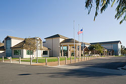
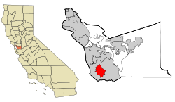
Ashland is a census-designated place (CDP) and unincorporated community in Alameda County, California, United States. The population was 23,823 at the 2020 census. Ashland is located between the city of San Leandro to the north, the unincorporated community of Cherryland to the south, the unincorporated community of Castro Valley to the east, and the unincorporated community of San Lorenzo to the southwest.

<span class="mw-page-title-main">Castro Valley, California</span> CDP in California, United States

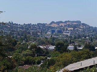
Castro Valley is a census-designated place (CDP) in Alameda County, California, United States. At the 2010 census, it was the fifth most populous unincorporated area in California. The population was 66,441 at the 2020 census.

<span class="mw-page-title-main">Cherryland, California</span> Unincorporated Community in California, United States

Cherryland is an unincorporated community and census-designated place (CDP) in Alameda County, California, United States. Cherryland is located between Ashland to the north and the city of Hayward to the south. The population was 15,808 at the 2020 census.

<span class="mw-page-title-main">Hayward, California</span> City in California, United States

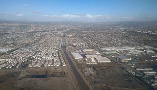
Hayward is a city located in Alameda County, California, United States, in the East Bay subregion of the San Francisco Bay Area. With a population of 162,954 as of 2020, Hayward is the sixth largest city in the Bay Area, and the third largest in Alameda County. Hayward was ranked as the 34th most populous municipality in California. It is included in the San Francisco–Oakland–San Jose Metropolitan Statistical Area by the US Census. It is located primarily between Castro Valley, San Leandro and Union City, and lies at the eastern terminus of the San Mateo–Hayward Bridge. The city was devastated early in its history by the 1868 Hayward earthquake. From the early 20th century until the beginning of the 1980s, Hayward's economy was dominated by its now defunct food canning and salt production industries.

<span class="mw-page-title-main">San Leandro, California</span> City in California, United States

San Leandro is a city in Alameda County, California, United States. It is located in the East Bay of the San Francisco Bay Area; between Oakland to the northwest, and Ashland, Castro Valley, and Hayward to the southeast. The population was 91,008 as of the 2020 census.

<span class="mw-page-title-main">San Lorenzo, California</span> Unincorporated community in California, United States

San Lorenzo is a census-designated place (CDP) located in the East Bay of the San Francisco Bay Area in Alameda County, California, United States. The population was 29,581 at the 2020 census. It is an unincorporated community, located at the banks of San Lorenzo Creek. It was originally named Squattersville in 1851, but later renamed to San Lorenzo.

<span class="mw-page-title-main">Sunol, California</span> Census-designated place in California, United States

Sunol is an unincorporated area and census-designated place in Alameda County, California. Located in the Sunol Valley of the East Bay, the population was 913 at the 2010 census. It is best known as the location of the Sunol Water Temple and for its historic tourist railroad system, the Niles Canyon Railway.

<span class="mw-page-title-main">Union City, California</span> City in California, United States

Union City is a city in Alameda County, California, United States in the San Francisco Bay Area. It is located approximately 19 miles (31 km) south of Oakland, 30 miles (48 km) from San Francisco, and 20 miles (32 km) north of San Jose. It was incorporated in 1959, combining the communities of Alvarado and Decoto. The city has 72,000 residents across a diverse population. Alvarado is a California Historical Landmark (#503). The city celebrated its 50th anniversary in 2009.

<span class="mw-page-title-main">Bay Point, California</span> CDP in California, United States

Bay Point, formerly West Pittsburg and originally Bella Vista is a census-designated place located in the East Bay region of the San Francisco Bay Area in Contra Costa County, California. Bay Point is just west of Pittsburg, California, and northeast of Concord, California, on the southern shore of Suisun Bay. The population of Bay Point was 21,349 as of 2010. The Pittsburg/Bay Point Station of the Bay Area Rapid Transit (BART) rail system is located adjacent to Bay Point in Pittsburg. The community is traversed by a freeway, State Route 4, the California Delta Highway. Being unincorporated, Bay Point does not have its own police department. The community is policed by the California Highway Patrol and the Contra Costa County Sheriff's Office. The ZIP code is 94565, and the area code is 925.

<span class="mw-page-title-main">Discovery Bay, California</span> Census-designated place in California, United States

Discovery Bay is a census-designated place (CDP) in eastern Contra Costa County, California in the United States, about 60 miles (97 km) from San Francisco. It is located in the San Francisco Bay Area. As of 2020, its population was 15,358, a 15% percent gain from 13,352 at the 2010 census.

<span class="mw-page-title-main">San Juan Bautista, California</span> City in California, United States

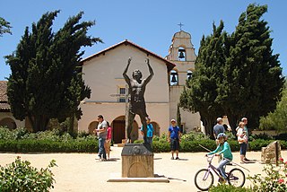
San Juan Bautista is a city in San Benito County, in the U.S. state of California. The population was 2,089 as of the 2020 census. San Juan Bautista was founded in 1797 by the Spanish under Fermín de Lasuén, with the establishment of Mission San Juan Bautista. Following the Mexican secularization of 1833, the town was briefly known as San Juan de Castro and eventually incorporated in 1896. Today, San Juan is a popular tourist destination, as the home of the San Juan Bautista State Historic Park and other important historic sites, as well as cultural institutions like El Teatro Campesino.

<span class="mw-page-title-main">Belmont, California</span> City in the US state of California

Belmont is a city in San Mateo County in the U.S. state of California. It is in the San Francisco Bay Area, on the San Francisco Peninsula about halfway between San Francisco and San Jose. Known for its wooded hills, views of the San Francisco Bay and stretches of open space, Belmont is a quiet residential community in the midst of the culturally and technologically rich Bay Area. It was originally part of Rancho de las Pulgas, for which one of its main roads, the Alameda de las Pulgas, is named. The city was incorporated in 1926. Its population was 28,335 at the 2020 census.

<span class="mw-page-title-main">Foster City, California</span> City in California, United States

Foster City is a city located in San Mateo County, California, United States. The 2020 census put the population at 33,805, an increase of more than 10% over the 2010 census figure of 30,567. Foster City is sometimes considered to be part of Silicon Valley for its local industry and its proximity to Silicon Valley cities. Foster City is one of the United States’ safest cities, with an average of one murder per decade.

<span class="mw-page-title-main">Fremont, Nebraska</span> City in Nebraska, United States

Fremont is a city and county seat of Dodge County in the eastern portion of the state of Nebraska in the Midwestern United States. The population was 27,141 at the 2020 census, making it the 6th most populous city in Nebraska. Fremont is the home of Midland University.

<span class="mw-page-title-main">Bear Valley, Mariposa County, California</span> Census-designated place in California, United States

Bear Valley is a census-designated place in Mariposa County, California, United States. It is located 10.5 miles (16.9 km) south-southeast of Coulterville, at an elevation of 2,054 feet (626 m). Bear Valley has been designated California Historical Landmark #331. The population was 156 at the 2020 census.

References

  1. "California Cities by Incorporation Date". California Association of Local Agency Formation Commissions. Archived from the original (Word) on November 3, 2014. Retrieved March 27, 2013.
  2. "Mayor Michael K. Hannon". City of Newark. Retrieved September 4, 2023.
  3. 1 2 "Senators". State of California. Retrieved March 18, 2013.
  4. 1 2 "Members Assembly". State of California. Retrieved March 18, 2013.
  5. 1 2 "California's 17th Congressional District - Representatives & District Map". Civic Impulse, LLC. Retrieved March 13, 2013.
  6. "2019 U.S. Gazetteer Files". United States Census Bureau. Retrieved July 1, 2020.
  7. "Newark". Geographic Names Information System . United States Geological Survey, United States Department of the Interior.
  8. 1 2 "U.S. Census Bureau QuickFacts: Newark city, California". United States Census Bureau. Retrieved September 26, 2021.
  9. "Archived copy". Archived from the original on September 29, 2011. Retrieved May 5, 2011.{{cite web}}: CS1 maint: archived copy as title (link)
  10. 1 2 "Newark's Roots". City of Newark official web site. Retrieved June 27, 2023.
  11. "Census of Population and Housing". Census.gov. Retrieved September 20, 2021.
  12. "City of Newark, Alameda County - 1950 Census". Bayareacensus.ca.gov. Retrieved September 17, 2016.
  13. "2010 Census Interactive Population Search: CA – Newark city". U.S. Census Bureau. Archived from the original on July 15, 2014. Retrieved July 12, 2014.
  14. "Bay Area Census". Bayareacensus.ca.gov. Retrieved July 21, 2020.
  15. "U.S. Census website". United States Census Bureau . Retrieved January 31, 2008.
  16. "American FactFinder - Community Facts". Archived from the original on February 11, 2020. Retrieved February 16, 2009.
  17. "Cargill Salt - San Francisco Bay: About Us". Archived from the original on July 16, 2011. Retrieved August 21, 2011.
  18. "History". Contracostatimes.com. April 2014. Retrieved May 4, 2014.
  19. "Archived copy". Archived from the original on August 19, 2018. Retrieved December 17, 2017.{{cite web}}: CS1 maint: archived copy as title (link)
  20. "History". Peterbilt web site. Archived from the original on February 9, 2013. Retrieved May 29, 2010.
  21. "History". Coachbuilt.com. Retrieved November 4, 2013.
  22. "City of Newark CAFR". Newark.org. Retrieved July 21, 2021.
  23. "Recreation & Community Services: Parks". City of Newark web site. Archived from the original on May 16, 2010. Retrieved May 29, 2010.
  24. "Silliman Center Official" (PDF). Newark.org. Retrieved April 17, 2008.
  25. "Historic Newark Days". Newark Days Inc. web site. Retrieved May 29, 2010.
  26. "google map". Maps.google.com. Retrieved April 17, 2008.
  27. "Dumbarton Rail Corridor". San Mateo County Transportation Authority. Retrieved January 24, 2007.
  28. "Terry Alderete". Hispanic Community Affairs Council. Archived from the original on December 12, 2013. Retrieved June 3, 2012.
  29. "Photographic image : Rollie Fingers card" (JPG). Images.checkoutmycards.com. Retrieved July 21, 2020.
  30. "Freddie Muller Stats". Baseball-Reference.com. Retrieved July 21, 2020.
  31. Argus, Saturday, January 23, 1965, Page 4
  32. Pamplin, Rushton "Rocky"; Hamady, Ron (July 22, 2018). The Beach Boys' Endless Wave: Inside America's Band. ISBN   978-1938620225.
  33. "Rocky Pamplin, 1968-69 | UO Athletics | Oregon Digital". Oregondigital.org. Retrieved July 21, 2020.
  34. "Photographic image : Joe Rudi card" (JPG). Images.checkoutmycards.com. Retrieved July 21, 2020.
  35. "Bay Area blues guitar legend Ron Thompson dies at age 66". Mercurynews.com. February 19, 2020. Retrieved July 21, 2020.
  36. "Christopher Titus". Tv.com. Retrieved July 21, 2020.
  37. The Genius: How Bill Walsh Reinvented Football and Created an NFL Dynasty by David Harris