Cherryland | |
---|---|
Coordinates: 37°40′46″N122°06′12″W / 37.67944°N 122.10333°W | |
Country | United States |
State | California |
County | Alameda |
Government | |
• State senator | Aisha Wahab (D) [1] |
• Assemblymember | Liz Ortega (D) [2] |
• U. S. rep. | Kevin Mullin (D) [3] |
Area | |
• Total | 1.19 sq mi (3.09 km2) |
• Land | 1.19 sq mi (3.09 km2) |
• Water | 0.00 sq mi (0.00 km2) 0% |
Elevation | 66 ft (20 m) |
Population (2020) | |
• Total | 15,808 |
• Density | 13,250.63/sq mi (5,114.51/km2) |
Time zone | UTC-8 (Pacific) |
• Summer (DST) | UTC-7 (PDT) |
ZIP code | 94541 |
Area code | 510, 341 |
FIPS code | 06-12902 |
GNIS feature IDs | 1867005, 2408020 |
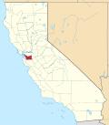
Cherryland is an unincorporated community and census-designated place (CDP) in Alameda County, California, United States. Cherryland is located between Ashland to the north and the city of Hayward to the south. The population was 15,808 at the 2020 census. [6]
Cherryland largely comprises the residential subdivision of the vast orchards (2,200 acres (8.9 km2)) of San Lorenzo pioneer William Meek, often called the "first farmer" of Alameda County. "Cherryland" was the name of one huge subdivision of this farm initiated by third-generation heirs in 1911. The Meek Mansion is located on Hampton Road in the northern part of Cherryland. The mansion is maintained by the Hayward Area Recreation and Park District, in conjunction with the Hayward Area Historical Society.
According to the United States Census Bureau, the CDP has a total area of 1.2 square miles (3.1 km2), all of it land. San Lorenzo Creek runs partly through the unincorporated community and outlines most of the unincorporated community's northern border.
This region experiences warm (but not hot) and dry summers, with no average monthly temperatures above 71.6 °F. According to the Köppen Climate Classification system, Cherryland has a warm-summer Mediterranean climate, abbreviated "Csb" on climate maps. [7]
Census | Pop. | Note | %± |
---|---|---|---|
1970 | 9,969 | — | |
1980 | 9,425 | −5.5% | |
1990 | 11,088 | 17.6% | |
2000 | 13,837 | 24.8% | |
2010 | 14,728 | 6.4% | |
2020 | 15,808 | 7.3% | |
U.S. Decennial Census [8] 1850–1870 [9] [10] 1880-1890 [11] 1900 [12] 1910 [13] 1920 [14] 1930 [15] 1940 [16] 1950 [17] 1960 [18] 1970 [19] 1980 [20] 1990 [21] 2000 [22] 2010 [23] |
The racial makeup of the CDP in 2010 was 20.9% non-Hispanic White, 10.8% Black or African American, 0.4% Native American, 9.2% Asian, 1.9% Pacific Islander, 0.2% from other races, and 2.7% from two or more races. 54.0% of the population were Hispanic or Latino of any race. The census reported that 14,272 people (96.9% of the population) lived in households, 277 (1.9%) lived in non-institutionalized group quarters, and 179 (1.2%) were institutionalized.
There were 4,643 households, 1,963 (42.3%) had children under the age of 18 living in them, 1,850 (39.8%) were opposite-sex married couples living together, 844 (18.2%) had a female householder with no husband present, 391 (8.4%) had a male householder with no wife present. There were 447 (9.6%) unmarried opposite-sex partnerships, and 50 (1.1%) same-sex married couples or partnerships. 1,131 households (24.4%) were one person and 324 (7.0%) had someone living alone who was 65 or older. The average household size was 3.07. There were 3,085 families (66.4% of households); the average family size was 3.64.
The age distribution was 3,956 people (26.9%) under the age of 18, 1,457 people (9.9%) aged 18 to 24, 4,728 people (32.1%) aged 25 to 44, 3,339 people (22.7%) aged 45 to 64, and 1,248 people (8.5%) who were 65 or older. The median age was 32.3 years. For every 100 females, there were 101.9 males. For every 100 females age 18 and over, there were 101.0 males.
There were 4,975 housing units at an average density of 4,155.5 units per square mile (1,604.4 units/km2),of which 4,643 were occupied, 1,458 (31.4%) by the owners and 3,185 (68.6%) by renters. The homeowner vacancy rate was 1.5%; the rental vacancy rate was 5.4%. 4,439 people (30.1% of the population) lived in owner-occupied housing units and 9,833 people (66.8%) lived in rental housing units.
At the 2000 census there were 13,837 people, 4,658 households, and 3,018 families living in the CDP. The population density was 11,859.2 inhabitants per square mile (4,578.9/km2). There were 4,823 housing units at an average density of 4,133.6 units per square mile (1,596.0 units/km2). [24] Of the 4,658 households 37.2% had children under the age of 18 living with them, 41.0% were married couples living together, 16.0% had a female householder with no husband present, and 35.2% were non-families. 25.9% of households were one person and 7.6% were one person aged 65 or older. The average household size was 2.87 and the average family size was 3.46.
The age distribution was 27.0% under the age of 18, 10.4% from 18 to 24, 35.6% from 25 to 44, 17.5% from 45 to 64, and 9.5% 65 or older. The median age was 32 years. For every 100 females, there were 105.0 males. For every 100 females age 18 and over, there were 101.0 males.
The median household income was $42,880 and the median family income was $44,319. Males had a median income of $34,830 versus $29,724 for females. The per capita income for the CDP was $16,929. About 9.0% of families and 12.3% of the population were below the poverty line, including 13.9% of those under age 18 and 12.1% of those age 65 or over.
Park and recreation services are provided by Hayward Area Recreation and Park District.
Cherryland is an unincorporated community of Alameda County, [25] and thus is overseen by the Alameda County Board of Supervisors. In 2019, the Board of Supervisors created the Eden Area Municipal Advisory Council, an appointed council of seven community members, to assist the Board of Supervisors in policy decision making.
Cherryland is served by the Hayward Unified School District to the south and the San Lorenzo Unified School District to the north.
Water supply is provided by the East Bay Municipal Utility District and sanitation services by the Oro Loma Sanitary District [26] Most other utility services are provided by private companies.
The area is policed by the Alameda County Sheriff's Office and the California Highway Patrol. Fire and EMT services provided by Alameda County Fire Department. [27]
There are a number of volunteer community organizations including the Cherryland Community Association and Padres Unidos.[ citation needed ]
Ashland is a census-designated place (CDP) and unincorporated community in Alameda County, California, United States. The population was 23,823 at the 2020 census. Ashland is located between the city of San Leandro to the north, the unincorporated community of Cherryland to the south, the unincorporated community of Castro Valley to the east, and the unincorporated community of San Lorenzo to the southwest.
Castro Valley is a census-designated place (CDP) in Alameda County, California, United States. At the 2010 census, it was the fifth most populous unincorporated area in California. The population was 66,441 at the 2020 census.
Fairview is a census-designated place (CDP) in Alameda County, California, United States. It borders on the city of Hayward and the census-designated place of Castro Valley. The population was 11,341 at the 2020 census.
San Lorenzo is a census-designated place (CDP) located in the East Bay of the San Francisco Bay Area in Alameda County, California, United States. The population was 29,581 at the 2020 census. It is an unincorporated community, located at the banks of San Lorenzo Creek. It was originally named Squattersville in 1851, but later renamed to San Lorenzo.
Caruthers is a census-designated place (CDP) in Fresno County, California, United States. The population was 2,497 at the 2010 census, up from 2,103 at the 2000 census. Caruthers is located 15 miles (24 km) south of downtown Fresno, at an elevation of 246 feet.
Charter Oak is a census-designated place (CDP) in Los Angeles County, California, approximately 26 miles (42 km) east of downtown Los Angeles. The population was 9,310 at the 2010 census, up from 9,027 at the 2000 census.
Citrus is a census-designated place (CDP) in Los Angeles County, California, United States. It is located in the San Gabriel Valley between Azusa to the north and west, Glendora to the east, and Covina to the south. The population was 10,866 at the 2010 census, up from 10,581 at the 2000 census. Citrus is named after Citrus Avenue, which passes through the community.
East Whittier is an unincorporated community in Los Angeles County, California, United States. The population was 9,757 at the 2010 census, up from 9,538 at the 2000 census. For statistical purposes, the United States Census Bureau has defined this community as a census-designated place (CDP). The name was changed from East La Mirada in 2012, likely due to its precise location in relation to the city of Whittier. The previous delineation of East Whittier CDP occurred during the 1960 census, when the area recorded a population of 19,884.
West Puente Valley is an unincorporated community and census-designated place in Los Angeles County, California, USA, northwest of La Puente. The population was 22,636 at the 2010 census, up from 22,589 at the 2000 census. The community is probably named for its location related to the city of La Puente.
Boronda is an unincorporated community and census-designated place (CDP) in Monterey County, California, United States. The population was 1,760 at the 2020 census. Boronda is located directly west of Salinas and is named after José Eusebio Boronda, a Californio ranchero, and located on the lands of his Rancho Rincón del Sanjón.
Bradley is an unincorporated community and census-designated place (CDP) in Monterey County, California, on the Salinas River 14 miles (23 km) south-southeast of San Ardo and 20 miles (32 km) north of Paso Robles. Bradley sits at an elevation of 548 feet (167 m). The population was 69 at the 2020 census, down from 93 at the 2010 census.
Canyondam is a census-designated place (CDP) in Plumas County, United States. Canyondam is located near the dam that forms Lake Almanor, 6.25 miles (10.1 km) east-southeast of Almanor. The population was 31 as of the 2010 census, down from 37 as of the 2000 census. On August 6, 2021, the community was destroyed in the Dixie Fire.
Highlands-Baywood Park is an unincorporated community and former census designated place (CDP) in San Mateo County, California, United States. The population was 4,027 at the 2010 census.
Aptos Hills-Larkin Valley is an unincorporated community in Santa Cruz County, California, United States. It is identified as one of several small communities with a combined population of 24,402 forming the unincorporated town of Aptos by the local Chamber of Commerce along with:
Casa Conejo is an unincorporated county island in Newbury Park, Ventura County, California, United States. It was the first planned community in Newbury Park and began building in 1960. When the city of Thousand Oaks incorporated 4 years later, the new developments in Newbury Park were incorporated into the city boundaries before being subdivided. The community is bordered by Old Conejo Road and US 101 to the north, Borchard Road to the south, Jenny Drive to the west, and Sequoia Middle School to the east. For statistical purposes, the United States Census Bureau has defined Casa Conejo as a census-designated place (CDP). The census definition of the area may not precisely correspond to local understanding of the area with the same name. The population was 3,249 at the 2010 census, up from 3,180 at the 2000 census. Casa Conejo is located in a roughly rectangle-shaped unincorporated area surrounded by the city of Thousand Oaks.
China Lake Acres is a census-designated place (CDP) in Kern County, California, United States. The population was 1,876 at the 2010 census, up from 1,761 at the 2000 census.
Baywood-Los Osos is an unincorporated community in western San Luis Obispo County, California. The population was 14,351 in the 2000 census. It includes the communities of Los Osos, which is located near Morro Bay, Baywood Park, and the former community of Cuesta-by-the-Sea.
Burbank is a unincorporated community in Santa Clara County, California. As an urban Island, it is surrounded by the city of San Jose. The population was 4,926 at the 2010 census. For statistical purposes, the United States Census Bureau has defined Burbank as a census-designated place (CDP). The area was named for horticulturist Luther Burbank.
Channel Islands Beach is an unincorporated community in Ventura County, California, United States consisting of three historic neighborhoods: Hollywood Beach, Hollywood by the Sea, and Silver Strand Beach. This densely populated narrow 1.3-mile-long strip (2.1 km) along the coastal edge of the Oxnard Plain was subdivided using the glamor of Hollywood to sell lots in the mid-1920s since the sand dunes had been used for movies. Adjacent development has left this sandy beachfront neighborhood hemmed in by Channel Islands Harbor and Naval Base Ventura County. The harbor mouth separates them into two communities resulting in a round-about travel route around the harbor between them although the Channel Islands Beach Community Services District provides local utilities services to the entire neighborhood. The Special-purpose district has an elected Board of Directors which provides a forum for the unique concerns of the community. Lying immediately adjacent but outside the corporate boundaries of the City of Oxnard and the City of Port Hueneme, they are governed by the county Board of Supervisors.
Malaga is a census-designated place in Fresno County, California. It is located 6 miles (9.7 km) south-southeast of downtown Fresno, at an elevation of 295 feet. As of the 2020 census, Malaga had a population of 884.