
Alameda County is located in the state of California in the United States. As of the 2020 census, the population was 1,682,353, making it the 7th-most populous county in the state and 21st most populous nationally. The county seat is Oakland. Alameda County is in the San Francisco Bay Area, occupying much of the East Bay region.

Livermore is a city in Alameda County, California, United States. With a 2020 population of 87,955, Livermore is the most populous city in the Tri-Valley. It is located on the eastern edge of California's San Francisco Bay Area. The current mayor is Bob Woerner.

Pleasanton is a city in Alameda County, California. Located in the Amador Valley, it is a suburb in the East Bay region of the Bay Area. The population was 79,871 at the 2020 census. In 2005 and 2007, Pleasanton was ranked the wealthiest middle-sized city in the United States by the Census Bureau. Pleasanton is home to the headquarters of Safeway, Workday, Ellie Mae, Roche Molecular Diagnostics, Blackhawk Network Holdings, and Veeva Systems. Other major employers include Kaiser Permanente, Oracle and Macy's. Although Oakland is the Alameda County seat, a few county offices are located in Pleasanton. The Alameda County Fairgrounds are located in Pleasanton, where the county fair is held during the last week of June and the first week of July. Pleasanton Ridge Regional Park is located on the west side of town.

Niles Canyon is a canyon in the San Francisco Bay Area formed by Alameda Creek, known for its heritage railroad and silent movie history. The canyon is largely in an unincorporated area of Alameda County, while the western portion of the canyon lies within the city limits of Fremont and Union City. The stretch of State Route 84 known as Niles Canyon Road traverses the length of the canyon from the Niles district of Fremont to the unincorporated town of Sunol. Two railroads also follow the same route down the canyon from Sunol to Niles: the old Southern Pacific track along the north side, now the Niles Canyon Railway, and the newer Union Pacific track a little to the south. At the west end of the canyon are the ruins of the Vallejo Flour Mill, which dates to 1853.
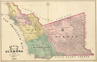
Washington Township is a former township of Alameda County, California in the San Francisco Bay Area region, which includes the present day cities of Union City, Fremont, and Newark. The first permanent settlement in the area was Mission San José, established in 1797. The township was formed in 1853, and named for president George Washington.
Eden Township is a former township of Alameda County, California in the San Francisco Bay Area region, which includes the present-day cities of Hayward and San Leandro, as well as the unincorporated census-designated areas of Ashland, Castro Valley, Cherryland, Fairview, and San Lorenzo. It was created from a group of Mexican land grants that were added to Alameda County when the county was established in 1853. Today there are several public and private agencies serving the region.
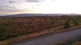
Sunol Valley is located in Alameda County, California, United States. The small town of Sunol lies in the valley. It is largely rural, but is in proximity to the highly populated Bay Area suburbs of Fremont, Pleasanton, and Livermore.

The Sunol Water Temple is located at 505 Paloma Way in Sunol, California. Designed by Willis Polk, the 59 foot high classical pavilion is made up of twelve concrete Corinthian columns and a concrete ring girder that supports the conical wood and tile roof. Inside the temple, water originally from the Pleasanton well fields and Arroyo de la Laguna flowed into a white tiled cistern before plunging into a deeper water channel carrying water from the filter galleries to the Niles Aqueduct in Niles Canyon and across San Francisco Bay near the Dumbarton Bridge. The roof covering the cistern has paintings depicting Native American maidens carrying water vessels. The temple is open to the public Monday to Friday, 9 a.m. to 3 p.m.

Alameda Creek is a large perennial stream in the San Francisco Bay Area. The creek runs for 45 miles (72 km) from a lake northeast of Packard Ridge to the eastern shore of San Francisco Bay by way of Niles Canyon and a flood control channel. Along its course, Alameda Creek provides wildlife habitat, water supply, a conduit for flood waters, opportunities for recreation, and a host of aesthetic and environmental values. The creek and three major reservoirs in the watershed are used as water supply by the San Francisco Public Utilities Commission, Alameda County Water District and Zone 7 Water Agency. Within the watershed can be found the highest peaks and tallest waterfall in the East Bay, over a dozen regional parks, and notable natural landmarks such as the cascades at Little Yosemite and the wildflower-strewn grasslands and oak savannahs of Sunol Preserve. After an absence of half a century, ocean-run steelhead trout will soon be able to return to Alameda Creek to mingle with remnant rainbow trout populations. Completion of a series of dam removal and fish passage projects, along with improved stream flows for cold-water fish and planned habitat restoration, will improve and restore habitat conditions for migratory fish. Steelhead trout and chinook salmon will soon be able to access up to twenty miles of spawning and rearing habitat in Alameda Creek and its tributaries. http://alamedacreek.org/learn-more/overview-watershed.php
Arroyo Mocho is a 34.7-mile-long (55.8 km) stream which originates in the far northeastern corner of Santa Clara County and flows northwesterly into eastern Alameda County, California. After traversing the cities of Livermore and Pleasanton it joins South San Ramon Creek to become Arroyo de la Laguna, which in turn flows to Alameda Creek and thence to San Francisco Bay.

Arroyo de la Laguna is a 7.5-mile-long (12.1 km) southward-flowing stream in Alameda County, California, United States which originates at the confluences of South San Ramon Creek and Arroyo Mocho. The Arroyo de la Laguna is fed by tributaries in the Amador Valley and certain eastern slope drainages of the Diablo Range; these tributaries include Arroyo Valle and Sinbad Creek. Arroyo del la Laguna is the major tributary to Alameda Creek which in turn flows into the San Francisco Bay.
The Bernal Subbasin is an aquifer located in the southwestern corner of Livermore Valley Groundwater Basin, Alameda County, California, United States. All of the groundwater in Livermore Valley moves toward the Bernal Subbasin, which is bounded on the east by Pleasanton Fault, on the north by the Park Fault, and on the west by the Calaveras Fault.(Earth Metrics, 1989) All the streams draining the Livermore Valley merge above the Bernal formation and exit this subbasin and Livermore Amador Valley via the Arroyo de la Laguna.

The Livermore Valley, historically known as the Valle de San José, is a valley in Alameda County, California, located in the East Bay region. The city of Livermore is located in the valley.
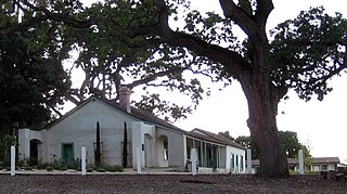
The Alviso Adobe Community Park is a 7-acre (2.8 ha) park in the city of Pleasanton, California, United States. It is built around an adobe house constructed in 1854 by Francisco Alviso on the Rancho Santa Rita Mexican Land Grant. The Alviso Adobe is a rare surviving example of an early American adobe that was continuously in use until 1969. The building is registered as California Historical Landmark #510 in 1954, but most of the historical marker was later found to be erroneous.
Amador Valley is a valley in eastern Alameda County, California and is the location of the cities of Dublin and Pleasanton. Part of Tri-Valley, the valley is bounded by the foothills of the Diablo Range on the north and south, Pleasanton Ridge to the west, and Livermore Valley to the east.

Rancho Las Positas was a 8,880-acre (35.9 km2) Mexican land grant in present-day Alameda County, California given in 1839 by governor Juan Alvarado to Robert Livermore and José Noriega. Las Positas means "little watering holes" in Spanish. The rancho included the present-day city of Livermore.
Rancho Santa Rita was a 8,894-acre (35.99 km2) Mexican land grant in the Amador Valley and western Livermore Valley, which is in present day Alameda County, California.
Rancho Valle de San José was a 48,436-acre (196.01 km2) Mexican land grant in present-day Alameda County, California. It was made up of the former pasture land belonging to Mission San José.
El Camino Viejo a Los Ángeles, also known as El Camino Viejo and the Old Los Angeles Trail, was the oldest north-south trail in the interior of Spanish colonial Las Californias (1769–1822) and Mexican Alta California (1822–1848), present day California. It became a well established inland route, and an alternative to the coastal El Camino Real trail used since the 1770s in the period.

Arroyo Valle or Arroyo Del Valle is a 36.4-mile-long (58.6 km) westward-flowing stream that begins in northeastern Santa Clara County, California, and flows northwesterly into Alameda County where it is dammed to form Lake Del Valle. After that Arroyo Valle is tributary to Arroyo de la Laguna which in turn flows into Alameda Creek and thence to San Francisco Bay. In the past, the Arroyo Valle had a significant steelhead migration; however, degradation of the stream in the latter half of the 20th century has decimated this anadromous fish population.

