Kilkare Woods, California

Last updated

Kilkare Woods
USA California location map.svg
Red pog.svg
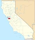
Kilkare Woods
Location in California
Coordinates: 37°37′42″N121°54′44″W / 37.62833°N 121.91222°W / 37.62833; -121.91222
Country United States
State California
Counties Alameda County
Elevation
[1]
827 ft (252 m)
Population
   Metro
773
Time zone UTC−8 (PST)
  Summer (DST) UTC−7 (PDT)
ZIP code
94586
Area code 925
GNIS ID [1] [2] 1656110
FIPS code [1] [2] 06-38464
†=figure is for zip code

Kilkare Woods, [1] also known as Kilcare Woods, [3] is a small rural unincorporated community of about 773 people [4] in southern Alameda County, California, near Pleasanton. [1]

Kilkare Woods began as a private association of summer cottages. [5] The town lies along Sinbad Creek beside Pleasanton Ridge Regional Park, at an elevation of 827 feet (252 meters). The town is only accessible through Sunol by Kilkare Road. 96% of residents of the ZIP code spoke English as their primary language, while 4% did not. Of those who did not, 3% spoke Hindi and 1% spoke Spanish. [6] Kilkare Woods is served by the CAL FIRE and Livermore-Pleasanton fire departments. Students attend elementary school at Sunol Glen Elementary School in Sunol and high school at Foothill High School in Pleasanton. Law enforcement services are provided by the Alameda County Sheriff's Office. [7]

Related Research Articles

<span class="mw-page-title-main">Alameda County, California</span> County in California, United States

Alameda County is a county located in the U.S. state of California. As of the 2020 census, the population was 1,682,353, making it the 7th-most populous county in the state and 21st most populous nationally. The county seat is Oakland. Alameda County is in the San Francisco Bay Area, occupying much of the East Bay region.

<span class="mw-page-title-main">Castro Valley, California</span> CDP in California, United States

Castro Valley is a census-designated place (CDP) in Alameda County, California, United States. At the 2010 census, it was the fifth most populous unincorporated area in California and the twenty-third most populous in the United States. The population was 66,441 at the 2020 census.

<span class="mw-page-title-main">Pleasanton, California</span> City in the San Francisco Bay Area

Pleasanton is a city in Alameda County, California, United States. Located in the Amador Valley, it is a suburb in the East Bay region of the San Francisco Bay Area. The population was 79,871 at the 2020 census. In 2005 and 2007, Pleasanton was ranked the wealthiest middle-sized city in the United States by the Census Bureau. Pleasanton is home to the headquarters of Safeway, Workday, Ellie Mae, Roche Molecular Diagnostics, Blackhawk Network Holdings, and Veeva Systems. Other major employers include Kaiser Permanente, Oracle and Macy's. Although Oakland is the Alameda County seat, a few county offices are located in Pleasanton. The Alameda County Fairgrounds are located in Pleasanton, where the county fair is held during the last week of June and the first week of July. Pleasanton Ridge Regional Park is located on the west side of town.

<span class="mw-page-title-main">Sunol, California</span> Census-designated place in California, United States

Sunol is an unincorporated area and census-designated place in Alameda County, California. Located in the Sunol Valley of the East Bay, the population was 913 at the 2010 census. It is best known as the location of the Sunol Water Temple and for its historic tourist railroad system, the Niles Canyon Railway.

<span class="mw-page-title-main">Avon, Indiana</span> Town in Indiana, United States

Avon is a town in Washington Township, Hendricks County, Indiana, United States. The population was 21,474 at the 2020 census. It is part of the Indianapolis metropolitan area.

<span class="mw-page-title-main">Brook, Indiana</span> Town in Indiana, United States

Brook is a town in Iroquois Township, Newton County, in the U.S. state of Indiana. The population was 997 at the 2010 census.

<span class="mw-page-title-main">Bedford Hills, New York</span> Hamlet & CDP in New York, United States

Bedford Hills is a hamlet and census-designated place (CDP) in the town of Bedford, Westchester County, New York, United States. The population was 3,001 at the 2010 census. Two New York State prisons for women, Bedford Hills Correctional Facility for Women and Taconic Correctional Facility, are located in the hamlet.

Canyon, formerly known as Sequoya, is an unincorporated community located near the border of Contra Costa and Alameda counties, in the U.S. state of California. It is situated between Oakland and Moraga in the San Francisco Bay Area. The community is named for its location in the upper canyon of San Leandro Creek along the eastern slope of the Berkeley Hills. Canyon lies at an elevation of 1138 feet.

<span class="mw-page-title-main">Niles Canyon</span> Geographic feature in California, United States

Niles Canyon is a canyon in the San Francisco Bay Area formed by Alameda Creek, known for its heritage railroad and silent movie history. The canyon is largely in an unincorporated area of Alameda County, while the western portion of the canyon lies within the city limits of Fremont and Union City. The stretch of State Route 84 known as Niles Canyon Road traverses the length of the canyon from the Niles district of Fremont to the unincorporated town of Sunol. Two railroads also follow the same route down the canyon from Sunol to Niles: the old Southern Pacific track along the north side, now the Niles Canyon Railway, and the newer Union Pacific track a little to the south. At the west end of the canyon are the ruins of the Vallejo Flour Mill, which dates to 1853.

<span class="mw-page-title-main">Mountain House, San Joaquin County, California</span> Unincorporated community in California, United States

Mountain House is a planned community in San Joaquin County, California. Mountain House is 5 miles (8.0 km) northwest of Tracy, 10 miles from Livermore, 0.5 miles from Interstate 580 to San Francisco, and about 50 miles (80 km) east of San Francisco. The population was 24,499 at the 2020 census. For statistical purposes, the United States Census Bureau has defined Mountain House as a census-designated place (CDP).

<span class="mw-page-title-main">Murray Township, Alameda County, California</span>

Murray Township was a township located in what is now the Livermore Valley portion of Alameda County, California, including the present day cities of Livermore, Dublin, and Pleasanton, and the census-designated place of Sunol.

<span class="mw-page-title-main">Sunol Water Temple</span> Ornamental structure in Sunol, California

The Sunol Water Temple is located at 505 Paloma Way in Sunol, California. Designed by Willis Polk, the 59 foot high classical pavilion is made up of twelve concrete Corinthian columns and a concrete ring girder that supports the conical wood and tile roof. Inside the temple, water originally from the Pleasanton well fields and Arroyo de la Laguna flowed into a white tiled cistern before plunging into a deeper water channel carrying water from the filter galleries to the Niles Aqueduct in Niles Canyon and across San Francisco Bay near the Dumbarton Bridge. The ceiling of the temple has panels with paintings by Yun Gee and other artists depicting a Native American maiden carrying water vessels, and women in classical poses. The temple is open to the public Monday to Friday, 9 a.m. to 3 p.m.

<span class="mw-page-title-main">Area code 925</span> Area code in California, United States

Area code 925 is a telephone area code in the North American Numbering Plan for a northern part of the U.S. state of California. It was created in an area code split of area code 510 in 1998. The numbering plan area comprises the inland portions of the East Bay counties of Alameda and Contra Costa.

Tormey, formerly known as El Cierbo from the (Spanish word 'Ciervo' for 'Elk', is an unincorporated community in Contra Costa County, California, United States. It is located between Rodeo and Crockett on the edge of the ConocoPhillips oil refinery in Rodeo. It is 6.5 miles west-northwest of Martinez, at an elevation of 20 feet. The community is home to less than a dozen homes and the former offices of the John Swett Unified School District.

<span class="mw-page-title-main">Arroyo Mocho</span> River in California, United States

Arroyo Mocho is a 34.7-mile-long (55.8 km) stream which originates in the far northeastern corner of Santa Clara County and flows northwesterly into eastern Alameda County, California. After traversing the cities of Livermore and Pleasanton it joins South San Ramon Creek to become Arroyo de la Laguna, which in turn flows to Alameda Creek and thence to San Francisco Bay.

<span class="mw-page-title-main">Pleasanton Unified School District</span> School district in California, United States

The Pleasanton Unified School District (PUSD) is a public primary and secondary education school district located in Pleasanton, California, United States, a suburban town east of San Francisco. It consists of nine elementary schools, three middle schools, two comprehensive high schools, and one alternative high school.

East Pleasanton is an unincorporated community in Alameda County, California. It is located 2.25 miles (3.6 km) east-northeast of Pleasanton, at an elevation of 384 feet (117 m).

Oleum was an unincorporated community in Contra Costa County, California, United States, located between the unincorporated town of Rodeo and Tormey. It was a small company town, with housing for Union Oil company workers, hence the name, derived from "petroleum". The refinery still exists. The site is located on the Mexican land grant Rancho El Pinole made to Ygnacio Martinez. A post office operated at Oleum from 1910 to 1951.

<span class="mw-page-title-main">Tassajara, California</span> Unincorporated community in California, United States

Tassajara, a variation of the Spanish word "tasajera", is an unincorporated community in Contra Costa County, California, United States. It is located on the east bank of Tassajara Creek, 6.5 miles (10 km) south-southeast of Mount Diablo, at an elevation of 709 feet. Together with Blackhawk it forms the Blackhawk-Camino Tassajara census designated place (CDP).

<span class="mw-page-title-main">Rancho Valle de San José</span>

Rancho Valle de San José was a 48,436-acre (196.01 km2) Mexican land grant in present-day Alameda County, California. It was made up of the former pasture land belonging to Mission San José.

References

  1. 1 2 3 4 5 "Kilkare Woods (Alameda County, California)". Geographic Names Information System . United States Geological Survey . Retrieved May 10, 2014.
  2. 1 2 "FIPS55 Data: California". FIPS55 Data . United States Geological Survey. February 23, 2006. Archived from the original on June 18, 2006. Retrieved May 10, 2014.{{cite web}}: External link in |work= (help)
  3. Durham, David L. (1998). California's Geographic Names: A Gazetteer of Historic and Modern Names of the State. Clovis, Calif.: Word Dancer Press. p. 648. ISBN   1-884995-14-4.
  4. 94586 entry, relocationnow.com, U.S. Census Bureau, Census 2000. Retrieved March 19, 2008.
  5. Edward G. Brooks, grandson of William Lode, Kilkare Woods maintenance manager, circa 1950s, based on Brooks' first-hand knowledge
  6. 94586 Archived 2012-12-05 at archive.today , MLA Data Center, American FactFinder, Census 2000, Summary File 3. Retrieved March 19, 2008.
  7. Victoria Christian (June 7, 2007). "Around Sunol". Sunol.net. Retrieved March 19, 2008.