
Alameda County is a county located in the U.S. state of California. As of the 2020 census, the population was 1,682,353, making it the 7th-most populous county in the state and 21st most populous nationally. The county seat is Oakland. Alameda County is in the San Francisco Bay Area, occupying much of the East Bay region.

Ashland is a census-designated place (CDP) and unincorporated community in Alameda County, California, United States. The population was 23,823 at the 2020 census. Ashland is located between the city of San Leandro to the north, the unincorporated community of Cherryland to the south, the unincorporated community of Castro Valley to the east, and the unincorporated community of San Lorenzo to the southwest.
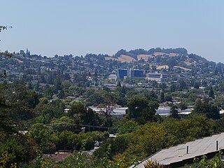
Castro Valley is a census-designated place (CDP) in Alameda County, California, United States. At the 2010 census, it was the fifth most populous unincorporated area in California. The population was 66,441 at the 2020 census.

Cherryland is an unincorporated community and census-designated place (CDP) in Alameda County, California, United States. Cherryland is located between Ashland to the north and the city of Hayward to the south. The population was 15,808 at the 2020 census.

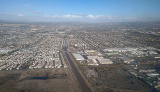
Hayward is a city located in Alameda County, California, United States, in the East Bay subregion of the San Francisco Bay Area. With a population of 162,954 as of 2020, Hayward is the sixth largest city in the Bay Area, and the third largest in Alameda County. Hayward was ranked as the 36th most populous municipality in California. It is included in the San Francisco–Oakland–San Jose Metropolitan Statistical Area by the US Census. It is located primarily between Castro Valley, San Leandro and Union City, and lies at the eastern terminus of the San Mateo–Hayward Bridge. The city was devastated early in its history by the 1868 Hayward earthquake. From the early 20th century until the beginning of the 1980s, Hayward's economy was dominated by its now defunct food canning and salt production industries.
San Lorenzo is a census-designated place (CDP) located in the East Bay of the San Francisco Bay Area in Alameda County, California, United States. The population was 29,581 at the 2020 census. It is an unincorporated community, located at the banks of San Lorenzo Creek. It was originally named Squattersville in 1851, but later renamed to San Lorenzo.

AC Transit is an Oakland-based public transit agency serving the western portions of Alameda and Contra Costa counties in the East Bay of the San Francisco Bay Area. AC Transit also operates "Transbay" routes across San Francisco Bay to San Francisco and selected areas in San Mateo and Santa Clara counties. AC Transit is constituted as a special district under California law. It is governed by seven elected members. It is not a part of or under the control of Alameda or Contra Costa counties or any local jurisdictions.
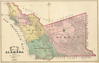
Murray Township was a township located in what is now the Livermore Valley portion of Alameda County, California, including the present day cities of Livermore, Dublin, and Pleasanton, and the census-designated place of Sunol.
Washington Township is a former township of Alameda County, California in the San Francisco Bay Area region, which includes the present day cities of Union City, Fremont, and Newark. The first permanent settlement in the area was Mission San José, established in 1797. The township was formed in 1853, and named for president George Washington.

Anthony Chabot Regional Park is a regional park in Oakland, Alameda County, California in the United States. It is part of the East Bay Regional Park District system, and covers 5,067 acres (2,051 ha) in the San Leandro Hills adjacent to Oakland, San Leandro and Castro Valley. Popular activities include hiking, cycling and horseback riding. A gun range operated by the Chabot Gun Club was shut down in 2016, following complaints about pollution.
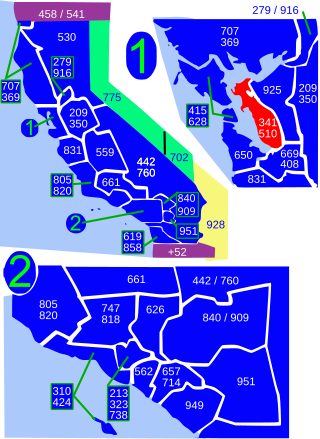
Area codes 510 and 341 are telephone area codes in the North American Numbering Plan (NANP) serving much of the East Bay in the U.S. state of California. They cover parts of Contra Costa County and western Alameda County, including the city of Oakland, but excluding Dublin, Livermore, Pleasanton, and Sunol.

Don Guillermo Castro, born in 1809 in Spanish Alta California, was a Californio ranchero, military officer, local justice of the peace and surveyor who once owned vast land holdings in Alameda County. He is the namesake of the unincorporated community of Castro Valley, California and his land included most of the modern City of Hayward, California.
California's 14th congressional district is a congressional district in the U.S. state of California. Eric Swalwell, a Democrat, has represented the district since January 2023.

Anthony Chabot was a nineteenth-century businessman and entrepreneur, notable for his contribution to developing hydraulic mining and for building water systems, especially in the Bay Area, so much that he became known as the "Water King".
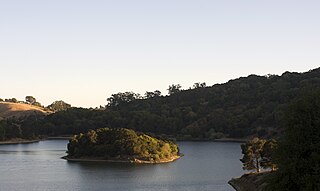
Lake Chabot is a man-made lake covering 317 acres (1.3 km2) in Alameda County, California, United States. Part of the lake lies within Oakland city limits, but most of it lies in unincorporated Castro Valley, just east of San Leandro. It was formed by the damming of San Leandro Creek. The lake was completed in 1875 to serve as a primary source of water for the East Bay.

San Leandro Creek is a 21.7-mile-long (34.9 km) year-round natural stream in the hills above Oakland in Alameda County and Contra Costa County of the East Bay in northern California.
Rancho San Leandro was a 6,830-acre (27.6 km2) Mexican land grant in present-day Alameda County, California given in 1842 by Governor Juan Alvarado to José Joaquín Estudillo. The grant extended along the east San Francisco Bay from San Leandro Creek south to San Lorenzo Creek, and encompassed present-day San Leandro.

The Hayward Area Recreation and Park District (H.A.R.D.) is the park management agency for most of the parks in the city of Hayward, California. It was created in 1944 and is an independent special district under California law. H.A.R.D. is the largest recreation district in California. It also manages parks in the bordering unincorporated communities of Castro Valley, San Lorenzo, Fairview, Ashland and Cherryland. It manages the park grounds for numerous schools in the region. Events and classes are scheduled and listed in a quarterly brochure. The parks' 2021 budget is $24,306,495.

Hayward Area Historical Society (HAHS) is a nonprofit organization dedicated to documenting the history of the city of Hayward, California and adjacent communities. These areas include San Lorenzo, Ashland, Cherryland, Castro Valley, Fairview, the former communities of Russell City, Mount Eden, Schafer Park, and other parts of unincorporated Alameda County. The society was founded in 1956. Their museum in Downtown Hayward closed in 2012. Their new facility opened nearby in 2014.

Elizabeth Ortega-Toro is an American politician and labor executive who is a member of the California State Assembly from the 20th district since 2022. A member of the Democratic Party, her district includes the southern East Bay of the San Francisco Bay Area.

