Castro Valley is named after Guillermo Castro, a noted 19th-century Mexican Californio ranchero who owned the land where the community is located.
History
Castro Valley is named after Don Guillermo Castro, a noted Mexican Californio ranchero who owned much of the area.
Before the arrival of European settlers the area was settled by the Chocheño (also spelled Chochenyo or Chocenyo) subdivision of the OhloneNative Americans.
With the arrival of Europeans, they established Mission San Jose in 1797. The area Castro Valley now occupies was part of the extensive colony of New Spain in what was the province of Alta California.
Castro Valley was part of the original 28,000acre(110km2) land grant given to Castro in 1840, called Rancho San Lorenzo. This land grant included Hayward, San Lorenzo, and Castro Valley, including Crow Canyon, Cull Canyon, and Palomares Canyons. Castro had a gambling habit and had to sell off portions of his land to pay gambling debts. The last of his holding was sold in a sheriff's sale in 1864 to Faxon Atherton for $400,000.[9]
Atherton (after whom the town of Atherton is named[9]) in turn began selling off his portion in smaller parcels. Two men named Cull (the namesake of Cull Canyon) and Luce bought some 2,400acres(10km2) and began running a steam-operated saw mill in Redwood Canyon. The Jensen brothers also bought land from Atherton in 1867.
In 1866, Redwood school was built, the first public school in the area. Many Portuguese families immigrated to the surrounding canyons (especially Palomares Canyon) and farmed large amounts of land, where their descendants remain today. In the 1870s, Lake Chabot, a reservoir and popular park, was built by Chinese laborers living at Camp Yema-Po. During the 1940s and 1950s, Castro Valley was known for its chicken ranches. Later it developed into a bedroom community, where workers live and commute to their jobs in the surrounding communities.[10]
The eastern hills of Castro Valley constitute the headwaters of the San Lorenzo Creek watershed and the origin of several creeks that flow into San Lorenzo Creek: Bolinas, Castro Valley, Chabot, Crow, Cull, Eden, Hollis, Kelly Canyon, Norris, and Palomares Creeks.
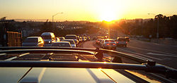
Interstate 580, with BART tracks in the center, near east Castro Valley
Castro Valley CDP, California – Racial and ethnic composition Note: the US Census treats Hispanic/Latino as an ethnic category. This table excludes Latinos from the racial categories and assigns them to a separate category. Hispanics/Latinos may be of any race.
The Census reported that 98.9% of the population lived in households, 0.3% lived in non-institutionalized group quarters, and 0.8% were institutionalized.[31]
There were 23,218 households, out of which 35.4% included children under the age of 18, 56.1% were married-couple households, 5.9% were cohabiting couple households, 23.6% had a female householder with no partner present, and 14.4% had a male householder with no partner present. 19.2% of households were one person, and 9.4% were one person aged 65 or older. The average household size was 2.83.[31] There were 17,369 families (74.8% of all households).[32]
The age distribution was 21.5% under the age of 18, 7.5% aged 18 to 24, 26.3% aged 25 to 44, 27.8% aged 45 to 64, and 16.9% who were 65years of age or older. The median age was 40.9years. For every 100 females, there were 94.5 males.[31]
There were 23,941 housing units at an average density of 1,421.0 unitsper square mile (548.7 units/km2), of which 23,218 (97.0%) were occupied. Of these, 67.2% were owner-occupied, and 32.8% were occupied by renters.[31]
In 2023, the US Census Bureau estimated that 30.8% of the population were foreign-born. Of all people aged 5 or older, 58.5% spoke only English at home, 9.5% spoke Spanish, 5.9% spoke other Indo-European languages, 22.9% spoke Asian or Pacific Islander languages, and 3.2% spoke other languages.[33]
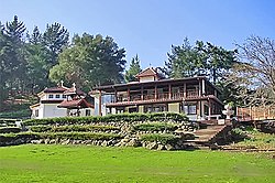
Rowell Rodeo Park
Economy
The economy of Castro Valley consists largely of the provision of goods and services for local residents. Being a primarily residential community, only about 5% of the area has been developed for commercial uses.[34]
The greatest number of people (6,683) are employed by the health care and social assistance industry, followed by the retail trade industry with 1,073 employees and accommodation and food service with 1,044 employees.[35] The health care and social assistance industry provided $1.1 billion in sales, shipments, receipts or revenue in 2012, which is the highest of all industries, and it is followed by the retail trade industry, which had a value of $324.1 million in sales, shipments, receipts or revenue.[35]
The median household income of residents was $138,069 in 2023, compared to a median income of $126,240 for all of Alameda County. The per capita income was $58,843, compared to $63,442 in all of Alameda County. The poverty rate was 7.5%, compared to 9.2% in all of Alameda County.[36]
Castro Valley is one of the sites where Joseph Eichler built some of the 10,000 or so homes he built in the Bay Area.[37] Castro Valley has a one-screen movie theater, the Chabot Cinema. The Castro Village complex on Castro Valley Boulevard is widely considered the commercial center of town.[38] The Harry Rowell Rodeo Ranch is located in Castro Valley and is managed by the Hayward Area Recreation and Park District. Rodeos are held there regularly.[39]
Historical landmarks and museums
Site of the first public school in Castro Valley
Interactive map of Site of the first public school in Castro Valley
The first public school in Castro Valley is a designated California Historical Landmark. A plaque is placed at the original site. The one-room schoolhouse was donated for "educational purposes only," by Josiah Grover Brickell in 1866. Brickell provided the salary for the first teacher. During the day the teacher taught children and in the evening they taught farmhands.[40] The school burned down in 1901. It was rebuilt and burned down again in 1920. A new school was built on another property.[41]
Castro Valley is an unincorporated community and thus is governed directly by the County of Alameda. There is no city police force, with policing provided by the Alameda County Sheriff's Office and the California Highway Patrol. Most of the community has fire protection provided by the Alameda County Fire Department, while the Five Canyons neighborhood has fire protection provided by the Fairview Fire Protection District. Castro Valley Sanitary District[43] provides refuse and sewer collection services for the majority of the community, with wastewater processed at the Oro Loma Wastewater Treatment Plant in San Lorenzo.
Efforts to incorporate Castro Valley have been voted down by its residents at the polls in both 1956 and 2002.[10][44] In lieu of a city council, Castro Valley is represented by a seven-member Municipal Advisory Council, which is an advisory body appointed to advise the Alameda County Board of Supervisors on local issues.[45]
Education
According to the 2019–2023 American Community Survey, educational attainment for Castro Valley residents at least 25 years old is 90.4% high school graduate and 43.9% bachelor's degree.[33]
Castro Valley has two public middle schools: Canyon Middle School and Creekside Middle School.
Castro Valley has nine public elementary schools: Castro Valley, Chabot, Independent, Jensen Ranch, Marshall, Palomares, Proctor, Stanton, and Vannoy.
The school district includes the Castro Valley Adult School.
Private schools
There is also a Roman Catholic school, called Our Lady of Grace (K–8), which is part of the Roman Catholic Diocese of Oakland. Redwood Christian Schools has one elementary school (K–5) Redwood Christian Elementary.[50]
Transportation
Castro Valley traffic
Interstate 580, which approaches from the east, makes a turn northward at Castro Valley. Interstate 238, which originates in Castro Valley, connects I-580 to Interstate 880. In addition to being served by those two freeways, Castro Valley is served with public transportation by bus system AC Transit, and rapid transit system BART with a station.
The primary local east–west arterial road is Castro Valley Boulevard, while Lake Chabot Road, Redwood Road and Crow Canyon Road are the major north–south arterials.[51]
Historically, Castro Valley Boulevard was part of the first transcontinental highway system, the Lincoln Highway.[52]
Through BART, Castro Valley has links to all three of the San Francisco Bay Area's major commercial airports, though the closest by distance is Oakland International Airport.
The three crosses of the Neighborhood Church form a prominent local landmark.Palomares Hills (on the east side of Castro Valley) looking south toward Palomares CanyonEden Medical Center
Services
Eden Medical Center operates in Castro Valley. It is a Sutter Health facility, and provides basic emergency medical services for the area.[53] Castro Valley Sanitary District runs wastewater treatment facilities, and was selected as California's best small wastewater system in 2002 and 2018.[54]
Notable people
Christopher Andersen, journalist, former editor of Time and People magazines, No. 1 New York Times bestselling author
↑Klatte, Arline. "Profile: Val Diamond". E-Guide Entertainment on the Gate. Hearst Communications Inc. Archived from the original on July 4, 2008. Retrieved August 11, 2008.
↑Chirazi, Steffan (October 5, 1997). "LOSING THE FAITH RENEWS MARTIN'S HOPE". San Francisco Chronicle. Hearst Communications, Inc. pp.PK-55. Retrieved November 16, 2008.{{cite news}}: CS1 maint: deprecated archival service (link)
This page is based on this Wikipedia article Text is available under the CC BY-SA 4.0 license; additional terms may apply. Images, videos and audio are available under their respective licenses.