This article needs additional citations for verification .(February 2017) |
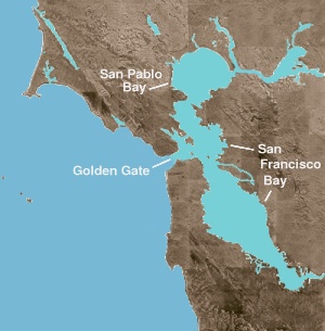
San Pablo Bay is a tidal estuary that forms the northern extension of San Francisco Bay in the East Bay and North Bay regions of the San Francisco Bay Area in northern California.
Most of the Bay is shallow; however, there is a deep water channel approximately in the middle of the bay, which allows access to major ports in Sacramento, Stockton, Benicia, and Martinez; and other smaller ports on the Sacramento–San Joaquin River Delta.
San Pablo Bay was named after Rancho San Pablo, a Spanish land grant given to colonial Alta California settlers in 1815, on the bay at the site of the present-day city of San Pablo. The bay is approximately 10 mi (16 km) across and has an area of approximately 90 sq mi (230 km2).
The bay receives the waters of the Sacramento and San Joaquin rivers, via Suisun Bay and the Carquinez Strait on its northeast end, and it connects to the Pacific Ocean via the San Francisco Bay on its southern end. The bay is heavily silted from the contributions of the two rivers, which themselves drain most of the Central Valley of California. San Pablo Bay also receives the waters of Sonoma Creek through the Napa Sonoma Marsh, San Rafael Creek, and the Petaluma River directly, and the Napa River which flows into the Carquinez Strait via the Mare Island Strait near its entrance into the bay. All tributaries except for Sonoma Creek are commercially navigable and maintained by the U.S. Army Corps of Engineers.
Two peninsulas separate San Pablo Bay from San Francisco Bay. The eastern, Point San Pablo, is in the city of Richmond and the western, Point San Pedro, borders the city of San Rafael. The bay is shared between Contra Costa county on the southern and eastern shore, and Solano, Sonoma and Marin counties on the northern and western shores. The county boundaries meet near the center of the bay. Communities on the shores of San Pablo Bay include: Richmond, San Pablo, Pinole, Hercules, Rodeo in Contra Costa County, Vallejo in Solano County, along with Novato and San Rafael in Marin County.
Because the Bay is close to several major and local airports, but outside of the main air traffic corridors, it is a popular pilot training area.
Because of its great size but shallow waters, San Pablo Bay frequently has difficult boating conditions. The prevailing western wind meets strong currents both at Carquinez Straits and, at the opposite end of the bay, near the Richmond Bridge, to produce large waves, with few areas of retreats for most boats.
There are many undeveloped shore lands with salt marshes and mudflats. The Bay is a primary wintering stop for the canvasback duck population on the Pacific Flyway, as well as a migratory staging ground for numerous species of waterfowl. Much of the northern shore of the bay is protected as part of the San Pablo Bay National Wildlife Refuge.
Endangered species that are found in the bay include the California brown pelican, California clapper rail, and salt marsh harvest mouse. This is a popular destination for recreation fishing, with Saltwater species including: striped bass, surfperch, sturgeon, starry flounder, leopard shark, topsmelt, and anchovy. In the 1880s there was a shrimp-fishing village, where some 500 Chinese people lived; they shipped approximately 90% of their catch to China. The location is now part of China Camp State Park.
San Pablo Bay is the setting of alternative rock band Primus's four-part song series "Fisherman's Chronicles," and is also referenced in "The Toys Go Winding Down" and "Harold of the Rocks." It is also mentioned in The Minus 5 song "John Barleycorn Must Live." In Susan Choi's book, American Woman, which mirrors the Patty Hearst scandal of the 1970s, the Bay's waters are said to welcome main characters Jenny and Pauline home after they've traversed from the East coast.
San Francisco Bay is a large tidal estuary in the U.S. state of California, and gives its name to the San Francisco Bay Area. It is dominated by the large cities of San Francisco, San Jose, and Oakland.
Wine Country is the region of California, in the northern San Francisco Bay Area, known worldwide as a premier wine-growing region. The region is famed for its wineries, its cuisine, Michelin star restaurants, boutique hotels, luxury resorts, historic architecture, and culture. Viticulture and wine-making have been practiced in the region since the Spanish missionaries from Mission San Francisco Solano established the first vineyards in 1812.
Suisun Bay is a shallow tidal estuary in Northern California. It lies at the confluence of the Sacramento River and San Joaquin River, forming the entrance to the Sacramento–San Joaquin River Delta, an inverted river delta. To the west, Suisun Bay is drained by the Carquinez Strait, which connects to San Pablo Bay, a northern extension of San Francisco Bay. Suisun Marsh, the tidal marsh land to the north, is the largest marsh in California. Grizzly Bay forms a northern extension of Suisun Bay. Suisun Bay is directly north of Contra Costa County.
The Carquinez Strait is a narrow tidal strait in Northern California. It is part of the tidal estuary of the Sacramento and the San Joaquin rivers as they drain into the San Francisco Bay. The strait is eight miles (13 km) long and connects Suisun Bay, which receives the waters of the combined rivers, with San Pablo Bay, a northern extension of the San Francisco Bay.
Benicia State Recreation Area is a state park unit of California, United States, protecting tidal wetland. It is located in the Solano County city of Benicia, 2 miles (3.2 km) west of downtown Benicia and borders Vallejo's Glen Cove neighborhood. The park covers 447 acres (181 ha) of marsh, grassy hillsides and rocky beaches along the narrowest portion of the Carquinez Strait. Southampton Creek and the tidal marsh front Southampton Bay, where the combined waters of the Sacramento and San Joaquin Rivers approach San Pablo Bay, the northern portion of San Francisco Bay.
The Napa River is a river approximately 55 miles (89 km) long in the U.S. state of California. It drains a famous wine-growing region called the Napa Valley, in the mountains north of the San Francisco Bay. Milliken Creek and Mt. Veeder watersheds are a few of its many tributaries. The river mouth is at Vallejo, where the intertidal zone of fresh and salt waters flow into the Carquinez Strait and the San Pablo Bay.
Sonoma Valley is a valley located in southeastern Sonoma County, California, in the North Bay region of the San Francisco Bay Area. Known as the birthplace of the California wine industry, the valley is home to some of the earliest vineyards and wineries in the state, some of which survived the phylloxera epidemic of the 1870s and the impact of prohibition in the early 20th century. Today, the valley's wines are promoted by the U.S. federal government's Sonoma Valley and Carneros AVAs.
The North Bay is a subregion of the San Francisco Bay Area, in California, United States. The largest city is Santa Rosa, which is the fifth-largest city in the Bay Area. It is the location of the Napa and Sonoma wine regions, and is the least populous and least urbanized part of the Bay Area. It consists of Marin, Napa, Solano and Sonoma counties.
The California Pacific Railroad Company was incorporated in 1865 at San Francisco, California as the California Pacific Rail Road Company. It was renamed the California Pacific Railroad Extension Company in the spring of 1869, then renamed the California Pacific Railroad later that same year. Its main railroad from Vallejo to Sacramento was completed six months prior to the May 1869 golden spike ceremony of the Central Pacific/Union Pacific Transcontinental Railway.
Sonoma Creek is a 33.4-mile-long (53.8 km) stream in northern California. It is one of two principal drainages of southern Sonoma County, California, with headwaters rising in the rugged hills of Sugarloaf Ridge State Park and discharging to San Pablo Bay, the northern arm of San Francisco Bay. The watershed drained by Sonoma Creek is roughly equivalent to the wine region of Sonoma Valley, an area of about 170 square miles (440 km2). The State of California has designated the Sonoma Creek watershed as a “Critical Coastal Water Resource”. To the east of this generally rectangular watershed is the Napa River watershed, and to the west are the Petaluma River and Tolay Creek watersheds.
San Francisco Bay in California has been served by ferries of all types for over 150 years. John Reed established a sailboat ferry service in 1826. Although the construction of the Golden Gate Bridge and the San Francisco–Oakland Bay Bridge led to the decline in the importance of most ferries, some are still in use today for both commuters and tourists.
The Napa Sonoma Marsh is a wetland at the northern edge of San Pablo Bay, which is a northern arm of the San Francisco Bay in California, United States. This marsh has an area of 48,000 acres (194 km2), of which 13,000 acres (53 km2) are abandoned salt evaporation ponds. The United States Government has designated 13,000 acres (53 km2) in the Napa Sonoma Marsh as the San Pablo Bay National Wildlife Refuge.
Tolay Creek is a 12.5-mile-long (20.1 km) southward-flowing stream in southern Sonoma County, California, United States, which flows through Tolay Lake and ends in north San Pablo Bay.
Carquinez Strait Regional Shoreline is a regional park, part of the East Bay Regional Park District system, located in northwestern Contra Costa County, California.
The Hydrography of the San Francisco Bay Area is a complex network of watersheds, marshes, rivers, creeks, reservoirs, and bays predominantly draining into the San Francisco Bay and Pacific Ocean.
Point San Pablo Harbor is a marina and small community at the far end of Point San Pablo in San Pablo Bay, within Richmond, in Contra Costa County, California. It is located at 1900 Stenmark Drive, Richmond CA 94801.
Little Island is a partially submerged marsh island in the Napa Slough, branching off from the Napa River upstream of San Pablo Bay. It is almost entirely in Napa County, California, although part of its southern tip is in Solano County; it is managed as part of the Napa-Sonoma Marshes Wildlife Area. Its coordinates are 38°10′48″N122°21′05″W, and the United States Geological Survey measured its elevation as 3 ft (0.91 m) in 1981.
Edgerly Island is an island in the Napa River, upstream of San Pablo Bay. It is in Napa County, California, and managed as part of the Napa-Sonoma Marshes Wildlife Area. Its coordinates are 38°12′12″N122°18′52″W, and the United States Geological Survey measured its elevation as 3 ft (0.91 m) in 1981.
Island No. 1 is a partially submerged island in the Napa River, upstream of San Pablo Bay. It is in Napa and Solano County, California, and parts of it are managed as part of the Napa-Sonoma Marshes Wildlife Area. Its coordinates are 38°08′35″N122°20′40″W, and the United States Geological Survey measured its elevation as 3 ft (0.91 m) in 1981. It, along with Island No. 2, Green Island and Tubbs Island, are labeled on a 1902 USGS map of the area.
Knight Island is a mostly-submerged island in the Napa River, upstream of San Pablo Bay. It is in Solano County, California, and managed as part of the Napa-Sonoma Marshes Wildlife Area. Its coordinates are 38°08′09″N122°17′58″W, and the United States Geological Survey measured its elevation as 3 ft (0.91 m) in 1981.