Related Research Articles
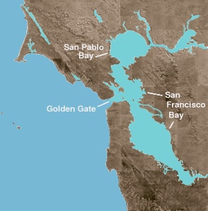
San Pablo Bay is a tidal estuary that forms the northern extension of San Francisco Bay in the East Bay and North Bay regions of the San Francisco Bay Area in northern California.

The Carquinez Strait is a narrow tidal strait located in the Bay Area of Northern California, United States. It is part of the tidal estuary of the Sacramento and the San Joaquin rivers as they drain into the San Francisco Bay. The strait is eight miles (13 km) long and connects Suisun Bay, which receives the waters of the combined rivers, with San Pablo Bay, a northern extension of the San Francisco Bay.

The Sacramento–San Joaquin River Delta, or California Delta, is an expansive inland river delta and estuary in Northern California. The Delta is formed at the western edge of the Central Valley by the confluence of the Sacramento and San Joaquin rivers and lies just east of where the rivers enter Suisun Bay, which flows into San Francisco Bay, then the Pacific Ocean via San Pablo Bay. The Delta is recognized for protection by the California Bays and Estuaries Policy. Sacramento–San Joaquin Delta was designated a National Heritage Area on March 12, 2019. The city of Stockton is located on the San Joaquin River at the eastern edge of the delta. The total area of the Delta, including both land and water, is about 1,100 square miles (2,800 km2). Its population is around 500,000.

The Yolo Bypass is one of the two flood bypasses in California's Sacramento Valley located in Yolo and Solano Counties. Through a system of weirs, the bypass diverts floodwaters from the Sacramento River away from the state's capital city of Sacramento and other nearby riverside communities.

The California State Coastal Conservancy is a non-regulatory state agency in California established in 1976 to enhance coastal resources and public access to the coast. The CSCC is a department of the California Natural Resources Agency. The agency's work is conducted along the entirety of the California coast, including the interior San Francisco Bay and is responsible for the planning and coordination of federal land sales to acquire into state land as well as award grant funding for improvement projects. The Board of Directors for the agency is made up of seven members who are appointed by the Governor of California and approved by the California Legislature, members of the California State Assembly and California State Senate engage and provide oversight within their legislative capacity.
San Francisco Baykeeper is a nonprofit environmental advocacy organization that uses science and the law to protect, preserve, and enhance the health of the ecosystems and communities that depend upon the San Francisco Bay, the San Francisco Bay-Delta Estuary, and its watershed. SF Baykeeper is the only organization, governmental or non-profit, that regularly patrols the Bay by boat and drone to document sources of pollution.
Aquarium of the Bay is a public aquarium located at The Embarcadero and Beach Street, at the edge of Pier 39 in San Francisco, California. The aquarium is focused on local aquatic animals from the San Francisco Bay and neighboring rivers and watersheds as far as the Sierra Mountains. Since 2005 the Aquarium has focused its mission on enabling ocean conservation and climate action both locally and globally. It is one of seven institutions under parent company Bay Ecotarium, the largest watershed conservation organization in the Bay Area
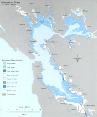
The Hydrography of the San Francisco Bay Area is a complex network of watersheds, marshes, rivers, creeks, reservoirs, and bays predominantly draining into the San Francisco Bay and Pacific Ocean.
The Peripheral Canal was a series of proposals starting in the 1940s to divert water from California's Sacramento River, around the periphery of the San Joaquin-Sacramento River Delta, to uses farther south. The canal would have attempted to resolve a problem with the quality of water pumped south. Pumps create such a powerful suction that the boundary between freshwater to saltwater has shifted inland, negatively affecting the environment. The pumps have increased by 5 to 7 million acre-feet the amount of water exported each year to the Central Valley and Southern California. However, the peripheral canal as proposed would have reduced the overall freshwater flow into the Delta and move the freshwater-saltwater interface further inland, causing damage to Delta agriculture and ecosystems.

The San Francisco Estuary together with the Sacramento–San Joaquin River Delta represents a highly altered ecosystem. The region has been heavily re-engineered to accommodate the needs of water delivery, shipping, agriculture, and most recently, suburban development. These needs have wrought direct changes in the movement of water and the nature of the landscape, and indirect changes from the introduction of non-native species. New species have altered the architecture of the food web as surely as levees have altered the landscape of islands and channels that form the complex system known as the Delta.
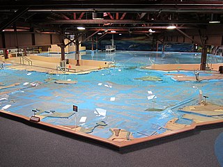
The U.S. Army Corps of Engineers Bay Model is a working hydraulic scale model of the San Francisco Bay and Sacramento-San Joaquin River Delta System. While the Bay Model is still operational, it is no longer used for scientific research but is instead open to the public alongside educational exhibits about Bay hydrology. The model is located in the Bay Model Visitor Center at 2100 Bridgeway Blvd. in Sausalito, California.
The Water Resources Collections and Archives (WRCA), formerly known as the Water Resources Center Archives, is an archive with unpublished manuscript collections and a library with published materials. It was established to collect unique, hard-to-find, technical report materials pertaining to all aspects of water resources and supply in California and the American West. Located on the campus of the University of California Riverside (UCR), it is jointly administered by the UCR College of Natural and Agricultural Sciences (CNAS) and the UCR Libraries. WRCA was part of the University of California Center for Water Resources (WRC) that was established and funded in 1957 by a special act of the California State Legislature and was designated the California Water Research Institute by a federal act in 1964.

The Water Quality Control Policy for the Enclosed Bays and Estuaries of California is published by the California State Water Resources Control Board as guidelines to prevent water quality degradation. The policy is revised as needed.

Save The Bay is a nonprofit organization dedicated to preserving San Francisco Bay and related estuarine habitat areas. It was founded by Catherine Kerr, Sylvia McLaughlin, and Esther Gulick in 1961.
The San Francisco Estuary Partnership (Partnership) is one of the 28 National Estuary Programs created in the 1987 Amendments to the Clean Water Act. The Partnership is a non-regulatory federal-state-local collaboration working to restore water quality and manage the natural resources of the San Francisco Bay-Sacramento–San Joaquin River Delta estuary. The Partnership works with over 100 municipalities, non-profits, governmental agencies, and businesses and helps develop, find funding for, and implement over 40 projects and programs aimed at improving the health of the estuary. The partnership either directly implements these projects, or administers and manages grants, holds educational workshops and highlights project results. The Partnership is also the official representative for the San Francisco Bay region to the Most Beautiful Bays in the World.
Delta Conveyance Project, formerly known as California Water Fix and Eco Restore or the Bay Delta Conservation Plan, is a $15 billion plan proposed by Governor Jerry Brown and the California Department of Water Resources to build a 36 foot diameter tunnel to carry fresh water from the Sacramento River southward under the Sacramento-San Joaquin Delta to Bethany Reservoir for use by the State Water Project and the Central Valley Project.

Winter Island is a 453-acre (183 ha) island in Suisun Bay, in the western Sacramento-San Joaquin River Delta. It is north of Pittsburg, separated from Browns Island to the west by a slough. It was private property, and contained one house. It is used as a duck hunting area, a wetland, and a dredging disposal area. In 2016 Winter Island was purchased by the California Department of Water Resources in order to restore the island as a tidal marsh. Winter Island is part of Contra Costa County, and managed by Reclamation District 2122. It is shown, labeled "Ruckels Island", on an 1850 survey map of the San Francisco Bay area made by Cadwalader Ringgold and an 1854 map of the area by Henry Lange.
The BayEcotarium, is a merger between The Bay Institute and the Aquarium of the Bay in 2009. Headquartered in San Francisco, CA, USA, the BayEcotarium is a 501(c)(3) nonprofit dedicated to protecting, restoring and inspiring conservation of the San Francisco Bay, from the Sierra to the sea.

Chipps Island is a small island in Suisun Bay, California. It is part of Solano County. It is also known as Knox Island, Its coordinates are 38°03′19″N121°54′43″W by which name it appears on an 1850 survey map of the San Francisco Bay area made by Cadwalader Ringgold, as well as an 1854 map of the area by Henry Lange. In 1959, the state of California used Chipps Island in a legal definition of the western boundary of the Sacramento–San Joaquin River Delta.

Golden State Salmon Association (GSSA) is a US non-profit organization dedicated to the conservation and restoration of California's salmon, primarily Chinook salmon, and their freshwater streams, rivers, and coastal habitats for their economic, recreational, commercial, environmental, cultural and health benefits. The organization began in 2010 in San Francisco, California, as the Golden Gate Salmon Association.
References
- ↑ "The Bay Institute - Advocates for the Health of greater San Francisco Bay". Bay Ecotarium. Retrieved 2024-03-17.
