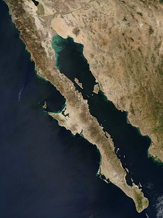
The Baja California peninsula is a peninsula in northwestern Mexico. It separates the Gulf of California from the Pacific Ocean. The peninsula extends from Mexicali, Baja California, in the north to Cabo San Lucas, Baja California Sur, in the south.

Marin County is a county located in the northwestern part of the San Francisco Bay Area of the U.S. state of California. As of the 2020 census, the population was 262,231. Its county seat and largest city is San Rafael. Marin County is across the Golden Gate Bridge from San Francisco, and is included in the San Francisco–Oakland–Berkeley, CA Metropolitan Statistical Area.

Belvedere is a residential incorporated city located on the San Francisco Bay in Marin County, California, United States. Consisting of two islands and a lagoon, it is connected to the Tiburon Peninsula by two causeways. At the 2020 census, the population was 2,126. The per capita income of Belvedere residents in 2000 was $250,000, but currently the average income is $283,000, making it one of the highest-income cities in California and the eighth highest-income community in the United States. Belvedere and Tiburon share a post office and the 94920 ZIP code.

Tiburon is an incorporated town in Marin County, California. It is located on the Tiburon Peninsula, which reaches south into the San Francisco Bay. It shares a ZIP code (94920) with the smaller incorporated city of Belvedere, which occupies the southwest part of the peninsula and is contiguous with Tiburon. Tiburon is bordered by Corte Madera to the north and Mill Valley to the west, but is otherwise mostly surrounded by the bay. Besides Belvedere and Tiburon, much of the peninsula is unincorporated, including portions of the north side and the communities of Strawberry and Paradise Cay.

Angel Island is an island in San Francisco Bay. The entire island is included within Angel Island State Park, administered by California State Parks. The island, a California Historical Landmark, has been used by humans for a variety of purposes, including seasonal hunting and gathering by indigenous peoples, water and timber supply for European ships, ranching by Mexicans, United States military installations, a United States Public Health Service Quarantine Station, and a U.S. Bureau of Immigration inspection and detention facility.
Richardson Bay is a shallow, ecologically rich arm of San Francisco Bay, managed under a Joint Powers Agency of four northern California cities. The 911-acre (369 ha) Richardson Bay Sanctuary was acquired in the early 1960s by the National Audubon Society. The bay was named for William A. Richardson, early 19th century sea captain and builder in San Francisco. It contains both Strawberry Spit and Aramburu Island.
The Raccoon Strait is a waterway of the San Francisco Bay between Angel Island and the Tiburon Peninsula, mainland Marin County, California, United States. During the ice ages, when sea levels were considerably lower and San Francisco Bay was a grassy valley, the combined Sacramento-San Joaquin river flowed through what is now Raccoon Strait before flowing through the canyon at the Golden Gate.

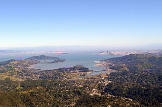
The Tiburon Peninsula is a landform of the San Francisco Bay Area's Marin County and is home to the incorporated municipalities of Tiburon, Belvedere, and a portion of Corte Madera, California. Much of the peninsula is unincorporated, including portions of the north side and the communities of Paradise Cay and Strawberry. Richardson Bay separates the peninsula from the Marin County mainland. Angel Island lies app. 1 mile south of the peninsula's southern tip. Much of the land area of the Tiburon Peninsula was part of a Spanish land grant originally given to the early Californian John Reed. A prominent feature of the Tiburon Peninsula is Ring Mountain, Marin County, which forms the backbone of the peninsula and is the highest elevation of the peninsula. The Tiburon Peninsula is the location of a number of rare and endangered flora species, and is also the site of ancient Native American rock carvings. The mineral lawsonite was first described from an occurrence on the Tiburon Peninsula.

Paradise Cay, also known as County Service Area No. 29, is an unincorporated enclave, surrounded by the town of Tiburon in Marin County, California, United States, located 2 miles (3 km) south of Point San Quentin at an elevation of 23 feet. The waterfront community lies at the foot of the Tiburon Peninsula south of Corte Madera Creek along the San Francisco Bay. The community is in ZIP code 94920 and area code 415.

The Lyford House is a Victorian house located in Tiburon, California. Built in 1876, the house is listed on the National Register of Historic Places.

Ring Mountain is an elevated landform on the Tiburon Peninsula in Marin County, California. This mountain was named for George E. Ring, who served as a Marin County Supervisor from 1895 to 1903.

Triangle Marsh is a wetland of the San Francisco Bay, situated at the base of Ring Mountain at the north end of the Tiburon Peninsula in Marin County, California.
John Thomas Reed was an early California European settler who was the grantee of Rancho Corte Madera del Presidio in what is now Marin County, California.

Old St. Hilary's Landmark is a former mission church place of worship and now a historic landmark owned and maintained by the Belvedere-Tiburon Landmarks Society, Tiburon Peninsula, Marin County, California, United States. The landmark is situated on the flank of the Tiburon Hills, an area characterized by serpentine soils and hence has a distinct plant community. The area surrounding the church is a Marin County protected area, the Old Saint Hilary's Open Space Preserve. The church building was listed on the National Register of Historic Places in 2020.

The Belvedere Tiburon Library is an independent public library serving the communities of Belvedere, Tiburon, and Strawberry, in California and it is operated by The Belvedere Tiburon Library Agency. It has as its mission the provision of library services now and in the future that will encourage and support a literate, enlightened and cultured community.
The Marin County Department of Parks and Open Space, consisting of the Marin County Parks and Landscape Division and the Marin County Open Space District, is a parks governing body in Marin County, California overseen by the Marin County Board of Supervisors. The current director and general manager is Max Korten.

Corinthian Island is a former island in the San Francisco Bay, that was later attached to the mainland. It is in Marin County, California, by the Tiburon Peninsula. Its coordinates are 37°52′22″N122°27′32″W, and the United States Geological Survey gave its elevation as 72 ft (22 m) in 1981. It appears on a 1950 USGS map of the area.

Many coastal peninsulas of California are properly headlands and are often called points, as in Oxford English Dictionary's senses 19b "projecting part of anything of a more or less tapering form...a sharp prominence" and 22 "a promontory or cape; the tip of a piece of land running out to sea...frequently in place names."

Old Saint Hilary's Open SpacePreserve is a county park located in Marin County, California. It is 122 acres large and is connected to the Tiburon Uplands, which is 24 acres. The preserve was created by several local initiatives in the 90’s to save the land from development. It is a popular place for hikers because of its views and other features. There have been initiatives to expand the preserve, such as one that passed in 2022 that aims to connect it with undeveloped, but formerly privately owned land on its perimeter.


