McLaughlin Eastshore State Park

Last updated

McLaughlin Eastshore State Park
McLaughlin Eastshore State Park 1.jpg
McLaughlin Eastshore State Park, December 2023
McLaughlin Eastshore State Park
Location San Francisco Bay Area (Alameda County, California)
Area1854 acres
Operated by East Bay Regional Park District
Map of Eastshore State Park EastshoreSPmap.png
Map of Eastshore State Park

McLaughlin Eastshore State Park is a state park and wildlife refuge along the San Francisco Bay shoreline of the East Bay between the cities of Richmond, Albany, Berkeley, Emeryville, and Oakland. It encompasses remnant natural wetlands, restored wetlands, as well as landfill west of the Eastshore Freeway. Its shoreline is 8.5 miles (13.7 km) long, and its total area is 1,854 acres (750 ha), which includes both tidelands and uplands. [1] Originally named just Eastshore State Park, it was renamed in October 2012 to honor the late Save the Bay founder Sylvia McLaughlin, [2] who, along with the late Dwight Steele of Citizens for Eastshore Park (now Citizens for East Shore Parks), drove the establishment of the park. Prior to 2013, it was jointly managed by the California State Parks and East Bay Regional Park District (EBRPD). The state agency and EBRPD executed a 30-year agreement for EBRPD to manage the park. [3]

Contents

History

McLaughlin Eastshore State Park in 2023 McLaughlin Eastshore State Park 3.jpg
McLaughlin Eastshore State Park in 2023

During the 1960s, it became obvious that the East Shore of the San Francisco Bay was suffering from rapid commercial development and the accumulation of trash. In particular, a 72-acre (29 ha) tract north of the Bay Bridge that extended between the cities of Emeryville and Richmond attracted the attention of commercial developers and environmental activists alike, though for different reasons. The waterfront property, primarily owned by Catellus Development Corporation—a subsidiary of the Atchison, Topeka and Santa Fe Railway (Santa Fe for short)—was already worth many millions of dollars, and would be worth far more if developed with shopping centers and high-rise hotels. [4]

Sylvia McLaughlin, a local housewife turned environmental activist, was alarmed enough by the situation to recruit friends and associates to form the non-profit Save San Francisco Bay Association, later renamed as Save the Bay. The newly formed association leaped into action, forming a shoreline park committee that began discussing how to raise funds for a small park in Berkeley in 1963. However, Save the Bay leaders soon realized that halting the dumping of material into the bay was a more urgent problem. In 1969 the state's Bay Conservation and Development Commission (BCDC) went from being an interim agency to a permanent state planning and regulatory entity. BCDC backed the idea that the state park system should buy the land. However California State Parks, which had little experience managing urban land and little interest in the complicated challenges of this particular polluted parcel, showed no interest in taking on the property. EBRPD, which was already operating eight urban shoreline parks, thought Cal Parks should be the lead agency. Furthermore, Santa Fe's owners felt certain that their property would become much more valuable if it remained in their hands. [4]

Santa Fe had a temporary setback in 1972, when the Berkeley City Council voted against allowing a proposed regional shopping center to be built atop a landfill. Santa Fe sued the city but lost the case in 1980, when the Supreme Court of California rejected the planned construction. A second setback had already occurred when the BCDC rejected Santa Fe's plan to build several high-rise buildings over wetlands in Emeryville. The Emeryville project became known by local people as "stilt city". [4] Soon after the Supreme Court ruling, the California State Park and Recreation Commission put the shoreline park on its list of priority projects to fund and issued an official East Bay Shoreline Report recommending establishment of an East Bay shoreline park and identified key lands for inclusion. Further progress on the park stopped when Republican George Deukmejian was elected Governor in 1983. [4]

Santa Fe continued its strategy of promoting large-scale development projects along the shorelines of Emeryville, Berkeley, and Albany. Its real estate subsidiary, Catellus Development Company, lost more court battles in the three cities before giving up in 1990. In 1998, with the state's finances recovering, voters approved two bond issues, one state and one regional, raising $40 million for purchasing land for the new Eastshore park. Also, a 1998 act in the California State Legislature authorized EBRPD to act for the state and use state funds to buy land for and operate the new Eastshore park. [4]

EBRPD had bought properties known as the Emeryville Crescent, Albany Mudflats, and part of Hoffman Marsh by 1992. By 1998 it had also purchased the Berkeley Meadow, Brickyard Cove, and the North Basin Strip (together considered of greater value than the narrow shoreline parcels). Catellus wanted $80 million for the former Santa Fe tract, but ultimately settled for $27.5 million after EBRPD threatened to employ eminent domain to acquire the property. [4]

In addition to the complicated process of buying parcels of land and landfill that would become the future state park, how areas were to be used was and remains controversial. The City of Berkeley was to have contributed its former landfill to become one of the larger areas of "upland" (dry land) for the park but held it back, apparently out of concerns that recreation would be overly restricted. (That 90 acres or so of capped landfill is now Cesar Chavez Park.) Albany's former landfill, the Albany Bulb, was hotly disputed—on one end of the spectrum, some wanted it to be entirely a conservation area that did not allow people; on the other, park users wanted continued access and recreation—and set aside to be transferred at some later point into the state park. (As of 2020, that has not happened.) North Point Isabel, a toxic landfill that was remediated and capped in the mid-1980s, had been popular for recreation, including off-leash dog walking. Sierra Club, Citizens for East Shore Parks, Golden Gate Audubon Society and others worked to restrict recreation on that spit of land and require dogs to be on-leash-only. In response to tremendous public support, state park planners authorized the continued use of North Point Isabel for off-leash recreation. Sierra Club opposed that.

Improvement projects funded in 2016

In March 2016, EBRPD announced that it would spend $2 million to extend the San Francisco Bay Trail, remove debris, toxic soil and invasive plants from two sections of the park, and remove the 53 foot (16 m) high dirt pile that has been considered an eyesore for more than ten years. The height of the pile will be lowered 15 feet (4.6 m) by grading, using the dirt to create small hills that would act as a buffer between the park and the adjacent freeway. The hills are to be seeded with native grasses, adding or improving habitat for shorebirds and other wildlife. A second contract will simultaneously complete the previously approved restoration of Albany Beach, which includes "... beach and dune enhancements, a non-motorized boat launch, restroom, parking and about a mile of the Bay Trail west of Golden Gate Fields." [1]

Adjacent parks

Notes

    See also

    Related Research Articles

    <span class="mw-page-title-main">Emeryville, California</span> City in California, United States

    Emeryville is a city located in northwest Alameda County, California, in the United States. It lies in a corridor between the cities of Berkeley and Oakland, with a border on the shore of San Francisco Bay. The resident population was 12,905 as of 2020. Its proximity to San Francisco, the Bay Bridge, the University of California, Berkeley, and Silicon Valley has been a catalyst for recent economic growth.

    <span class="mw-page-title-main">East Bay Regional Park District</span> Special District in Alameda and Contra Costa Counties, California

    The East Bay Regional Park District (EBRPD) is a special district operating in Alameda County and Contra Costa County, California, within the East Bay area of the San Francisco Bay Area. It maintains and operates a system of regional parks which is the largest urban regional park district in the United States. The administrative office is located in Oakland.

    <span class="mw-page-title-main">Point Pinole Regional Shoreline</span> Regional park in San Pablo Bay, California

    Point Pinole Regional Shoreline is a regional park on the shores of the San Pablo Bay, California, in the United States. It is approximately 2,315 acres (9.37 km2) in area, and is operated by the East Bay Regional Park District. It includes the Dotson Family Marsh and the Point Pinole Lagoon and hosts the North Richmond Shoreline Festival.

    <span class="mw-page-title-main">Shoreline Park, Mountain View</span> Park in Mountain View, California, United States

    Shoreline at Mountain View is a park in Mountain View, California, United States. The city park was dedicated in 1983, some fifteen years after the City undertook the daunting task of planning a regional park that would provide citizens with environmentally savvy recreation opportunities, from a site that was originally a landfill.

    <span class="mw-page-title-main">Golden Gate Fields</span> Horse racing venue in California

    Golden Gate Fields is an American horse racing track straddling both Albany, California and Berkeley, California along the shoreline of the San Francisco Bay adjacent to the Eastshore Freeway in the San Francisco Bay Area. With the closing of the Bay Meadows racetrack on May 11, 2008, it became the only major Thoroughbred racetrack in Northern California. It is currently owned by The Stronach Group.

    <span class="mw-page-title-main">Brooks Island Regional Preserve</span> Island in the United States of America

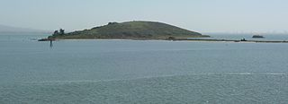
    Brooks Island Regional Preserve includes both the 75-acre (30 ha) of Brooks Island above the low-tide line and 300 acres (120 ha) of the surrounding bay. The only public access to the island is via an East Bay Regional Park District naturalist tour.

    <span class="mw-page-title-main">California and Nevada Railroad</span>

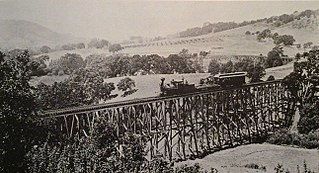
    The California and Nevada Railroad was a 3 ft narrow gauge steam railroad which ran in the East Bay of the San Francisco Bay Area in the late 19th century. It was incorporated on March 25, 1884. J.S. Emery was listed as the railroad's president - the present day city of Emeryville is named after him. On March 1, 1885, the track was completed between Oakland and San Pablo via Emeryville. The track to Oak Grove was completed on January 1, 1887.

    <span class="mw-page-title-main">Schoolhouse Creek (Alameda County)</span>

    Schoolhouse Creek is a creek which flows through the city of Berkeley, California in the San Francisco Bay Area.

    Catellus Development Corporation is an Oakland, California based real estate developer founded in 1984 to be the real estate division of Santa Fe Pacific Corporation, as part of the Santa Fe–Southern Pacific merger. It was spun off into its own company in 1989, after the two railroads split. Catellus created contemporary developments throughout California, including the East Bay Bridge shopping center and Bridgecourt apartment complex in Emeryville in the San Francisco Bay Area. Catellus was also a proponent of the Emery Go-Round tram network.

    <span class="mw-page-title-main">Point Isabel Regional Shoreline</span> Multi-use park

    Point Isabel Regional Shoreline in Richmond, California, is operated by East Bay Regional Park District, and is a multi-use park for joggers, windsurfers, kayakers, photographers, picnickers, and people walking dogs. It has access for pedestrians and via public transit, private vehicles, and bikes. It also features a concession offering food for people and grooming for pets. A longtime community organization and nonprofit, Point Isabel Dog Owners and Friends (PIDO), is active in the maintenance and improvement of the park.

    <span class="mw-page-title-main">César Chávez Park</span> City park of Berkeley, California

    César Chávez Park is a 90 acres (36 ha) city park of Berkeley, California named after César Chávez. It can be found on the peninsula on the north side of the Berkeley Marina in the San Francisco Bay and is adjacent to Eastshore State Park.

    <span class="mw-page-title-main">Briones Regional Park</span>

    Briones Regional Park is a 6,117-acre (24.75 km2) regional park in the East Bay Regional Park District (EBRPD) system, located in the Briones Hills of central Contra Costa County of the San Francisco Bay Area in California.

    <span class="mw-page-title-main">Brushy Peak Regional Preserve</span>

    Brushy Peak Regional Preserve is a regional park that is part of the East Bay Regional Parks (EBRPD) and the Livermore Area Recreation and Park District (LARPD) systems. It is located in unincorporated land in Alameda County, just north of Livermore, California.

    <span class="mw-page-title-main">Crown Memorial State Beach</span> State park in California, United States

    Crown Memorial State Beach is a state park in the city of Alameda, California on the shores of San Francisco Bay. It is operated by East Bay Regional Parks District (EBRPD), under a cooperative agreement with the State of California and the City of Alameda.

    Hoffman Marsh is a wetlands on San Francisco Bay in Richmond, California. The marsh has been protected within Eastshore State Park, and adjacent to Point Isabel Regional Shoreline. The marsh is an important nesting ground for wildfowl and stopping ground on the Pacific Flyway, as it is one of only a handful of undestroyed wetlands in the Bay Area. It borders Point Isabel Regional Shoreline and Interstate 80.

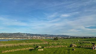
    Citizens for East Shore Parks (CESP) is a United States environmental organization that focuses on the acquisition and preservation of parkland in the San Francisco Bay Area. CESP works to protect open space along the East Bay shoreline for natural habitat and recreational purposes through a combination of advocacy, education, and outreach. Since its founding in 1985, CESP has worked to secure approximately 1,800 acres (730 ha) of public land, primarily through the creation of the 8.5-mile (13.7 km) long Eastshore State Park in 2002.

    <span class="mw-page-title-main">Albany Bulb</span> Former landfill in Albany, California

    Oyster Bay Regional Shoreline is a park in San Leandro, California, part of the East Bay Regional Park District (EBRPD). It is located along the eastern shore of San Francisco Bay directly to the south of Oakland International Airport. The property was originally used as a landfill for 37 years, until it was filled to capacity in 1977, when it was capped with a clay cover. EBRPD bought the property in 1980, intending to use it as a park.

    <span class="mw-page-title-main">Emeryville mudflat sculptures</span> Found object sculptures in California, USA

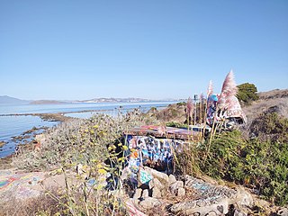
    The Emeryville mudflat sculptures were a series of found object structures along the San Francisco Bay shoreline of Emeryville, California, largely constructed from discarded materials found on-site such as driftwood. The mudflat sculptures were first erected in 1962 and received national attention by 1964; through the 1960s and 70s, anonymous, usually amateur artists would construct sculptures visible to traffic at the eastern end of the Bay Bridge. With the creation of the Emeryville Crescent State Marine Reserve in 1985 and increased attention to ecosystem preservation, the last mudflat sculptures were removed in 1997.

    References

    1. 1 2 " McLaughlin Eastshore State Park improvements." Santa Cruz Sentinel. March 21, 2016. Accessed June 10, 2017.
    2. "McLoughlin Eastshore State Park". East Bay Regional Park District. Retrieved September 6, 2015.
    3. "Berkeley Voice community briefs: Regional parks contract at Eastshore extended; arrests in smartphone thefts; University Village project discussion." Mercury News. June 5, 2013. Accessed June 10, 2017.
    4. 1 2 3 4 5 6 Krieger, Lisa (March 28, 2017). "How the East Bay Shoreline Became a Park for the People". Bay Nature. Retrieved June 11, 2017.

    37°52′5″N122°18′30″W / 37.86806°N 122.30833°W / 37.86806; -122.30833