
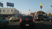
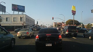
Macdonald Avenue is the main east-to-west artery in Richmond, California. [1]
Macdonald Avenue is the main east-to-west artery in Richmond, California. [1]
Macdonald Avenue runs in a straight line from the Richmond Parkway through downtown to San Pablo Avenue, after which it continues as a minor street for a few blocks, ending at Ludwig Avenue in El Cerrito. The portion from about 8th Street through 16th Street was historically the main commercial area of Richmond.
Bus service is provided along the entire length of the corridor west of San Pablo Avenue on AC Transit route 72M. The avenue fronts the Richmond Civic Center and Macdonald 80 Shopping Centers. BART, Capitol Corridor, and Amtrak share the Richmond BART/Amtrak station along the avenue, the end of the line. The station serves as a transit hub for trains and AC and Golden Gate Transit buses.

AC Transit is an Oakland-based public transit agency serving the western portions of Alameda and Contra Costa counties in the East Bay of the San Francisco Bay Area. AC Transit also operates "Transbay" routes across San Francisco Bay to San Francisco and selected areas in San Mateo and Santa Clara counties. AC Transit is constituted as a special district under California law. It is governed by seven elected members. It is not a part of or under the control of Alameda or Contra Costa counties or any local jurisdictions.

The M Ocean View is a light rail line that is part of the Muni Metro system in San Francisco, California. Named after the Oceanview neighborhood, it runs between San Jose and Geneva and Embarcadero station, connecting Oceanview, San Francisco State University, and Stonestown Galleria with the city center. The line opened on October 6, 1925.

Richmond station is an Amtrak intercity rail and Bay Area Rapid Transit (BART) station located in downtown Richmond, California. Richmond is the north terminus of BART service on the Orange Line and Red Line; it is a stop for Amtrak's Capitol Corridor, San Joaquins, and California Zephyr routes. The accessible station has one island platform for the two BART tracks, with a second island platform serving two of the three tracks of the Union Pacific Railroad Martinez Subdivision for Amtrak trains. It is one of two transfer points between BART and Amtrak, along with Oakland Coliseum station.
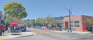
Solano Avenue in Berkeley and Albany, California is a two-mile (3.2 km) long east-west street. Solano Avenue is one of the larger shopping districts in the Berkeley area. Businesses along Solano Avenue cover a wide range, including grocery stores, coffee shops, drugstores, bookstores, antique dealers, apparel outlets, ethnic restaurants and a movie theater.

Emeryville station is an Amtrak station in Emeryville, California, United States. The station is served by the California Zephyr, Capitol Corridor, Coast Starlight, and San Joaquins. The station is the primary connection point for Amtrak Thruway buses serving San Francisco.

The Richmond Parkway Transit Center, or RPTC, is a park and ride lot and bus terminal located in Richmond, California. It is named after the adjacent Richmond Parkway and serves as a transfer point for WestCAT and AC Transit. The center is situated on the corner of Richmond Parkway and Blume Drive, near the Pinole border and adjacent to Interstate 80 and the Hilltop Plaza shopping center.

People in the San Francisco Bay Area rely on a complex multimodal transportation infrastructure consisting of roads, bridges, highways, rail, tunnels, airports, seaports, and bike and pedestrian paths. The development, maintenance, and operation of these different modes of transportation are overseen by various agencies, including the California Department of Transportation (Caltrans), the Association of Bay Area Governments, San Francisco Municipal Transportation Agency, and the Metropolitan Transportation Commission. These and other organizations collectively manage several interstate highways and state routes, eight passenger rail networks, eight trans-bay bridges, transbay ferry service, local and transbay bus service, three international airports, and an extensive network of roads, tunnels, and bike paths.
23rd Street is a major north-south trunk street in Richmond and San Pablo, California flanked by many Latino-oriented businesses.

The station complex of Amtrak's Oakland Coliseum station and Bay Area Rapid Transit (BART)'s Coliseum station is located in the East Oakland area of Oakland, California, United States. The two stations, located about 600 feet (180 m) apart, are connected to each other and to the Oakland Coliseum/Oakland Arena sports complex with an accessible pedestrian bridge. The BART station is served by the Orange, Green, and Blue lines; the Amtrak station is served by the Capitol Corridor service.

Richmond Heights, formerly East Richmond and also known as Mira Vista, is a district of eastern Richmond, California, in the San Francisco Bay Area.

Downtown Richmond is the old center of Richmond, California. The area is roughly bordered by 6th street to the west, 23rd Street to the east, Barrett Avenue to the north, and Macdonald Avenue to the south. The area once featured major department stores and other chains such as J.C. Penney, Macy's, S. H. Kress & Co., and Sears before Hilltop Mall was built in the 1970s.The area is currently undergoing a revitalization effort by the city, which has included the Richmond Shopping Center anchored by a supermarket. The Richmond Transit Village—coined Metro Walk by the developers, the Olson Company—has also been built, along with remodeling of the Richmond BART and Amtrak station and a bus transit center served by AC Transit and Golden Gate Transit. A Kaiser Permanente hospital and a Social Security Administration processing center provide for a majority of the jobs in the area.

Williamsburg Transportation Center is an intermodal transit station in Williamsburg, Virginia. Operated by the Williamsburg Area Transit Authority, it also serves Amtrak's Northeast Regional train as well as Greyhound Lines and Hampton Roads Transit intercity buses. The transportation center was formerly a Chesapeake and Ohio Railway (C&O) passenger station.

Downtown Oakland is the central business district of Oakland, California, United States. It is located roughly bounded by both the Oakland Estuary and Interstate 880 on the southwest, Interstate 980 on the northwest, Grand Avenue on the northeast, and Lake Merritt on the east.

Hayward station is an Amtrak intercity train station in Hayward, California, United States. It is served by seven daily round trips of the Capitol Corridor route. The station has two side platforms serving the main track and a passing siding; most trains use the platform on the main track.

Hercules Transit Center is a major commuter hub in the western Contra Costa County city of Hercules, California. It is anchored by WestCAT bus services. The center was originally on San Pablo Avenue. In August 2009, the transit center was relocated to the other side of I-80 with additional paid parking, which is $3/day.

Macdonald 80 Shopping Center, or Macdonald 80, is a 200,000 sq. ft. (18,580m³) regional shopping mall in the North & East neighborhood in Richmond, California, anchored by a Target store. The center was largely demolished and rebuilt after suffering from urban decay and blight. It is the only entirely LEED certified mall. It is anchored by a large Target store.

Milpitas station, also known as Milpitas Transit Center, is an intermodal transit station located near the intersection of East Capitol Avenue and Montague Expressway in Milpitas, California, United States. The station is served by the Orange and Green lines of Bay Area Rapid Transit (BART), the Orange Line of the VTA light rail system, VTA buses, and AC Transit buses.
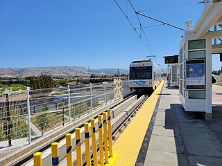
The Orange Line is a light rail line in Santa Clara County, California, and part of the VTA light rail system. It serves 26 stations in the cities of Mountain View, Sunnyvale, Santa Clara, Milpitas, and San Jose, traveling between Downtown Mountain View and Alum Rock stations, stopping at Ames Research Center, Great America, and Levi's Stadium along the way. The line connects to Caltrain at Mountain View and to the Bay Area Rapid Transit (BART) system at Milpitas station. The line runs for 20 hours per day on weekdays, with headways of 15 minutes for most of the day. On weekends, the train runs at 20-minute headways for most of the day. After around 8 pm on weekdays and weekends trains run at 30-minute headways.

Tempo is a bus rapid transit (BRT) service in Oakland and San Leandro in California. It is operated by AC Transit as Line 1T. The route has dedicated lanes and center-boarding stations along much of the corridor, prepaid fares, signal preemption, and all-door boarding. It is AC Transit's busiest bus route, with an average of 13,615 riders boarding each weekday in Fall 2022.
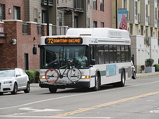
The 72 is a bus route in the East Bay operated by AC Transit. It serves the San Pablo Avenue corridor between Jack London Square in Oakland and Hilltop Mall in Richmond. The service is descendant from the original streetcar lines that ran along the street.
| | This California road–related article is a stub. You can help Wikipedia by expanding it. |