
The Castro Rocks are several rocks in Richmond, California protruding from the waters in San Francisco Bay between Castro Point and Red Rock Island. The rocks lie almost directly under the Richmond-San Rafael Bridge (I-580). [1]
The Castro Rocks are several rocks in Richmond, California protruding from the waters in San Francisco Bay between Castro Point and Red Rock Island. The rocks lie almost directly under the Richmond-San Rafael Bridge (I-580). [1]
The rocks are named after Don Víctor Castro, a local rancho-era land owner.[ citation needed ] They are shown as "Castro Rocks" on an 1850 survey map of the San Francisco Bay area made by Cadwalader Ringgold. [2]
Castro Rocks are the home of many harbor seals, [3] which lie on them to rest and sunbathe. The rocks are the largest harbor seal rookery in the northern San Francisco Bay and the second largest in the Bay Area itself. [4] There are also sometimes sea lions on the rocks. [5] The rock's Harbor Seals also frequent Mowry Slough, Brooks Island, Yerba Buena Island, and Mare Island. [6]
The seals at this location have high levels of toxic pollutants including the DDT, PCBs, PBDEs, PFOS, PFOA, and mercury. [7]
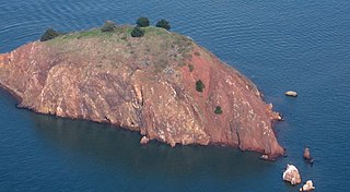
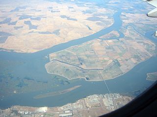
Red Rock Island is an uninhabited, 5.8-acre (2.3 ha) island in the San Francisco Bay located just south of the Richmond–San Rafael Bridge. The property is the only privately owned island in San Francisco Bay. The boundaries of three counties – San Francisco, Marin, and Contra Costa – converge on the island. The San Francisco County portion is an incorporated part of the city of San Francisco since it is a consolidated city-county; the Contra Costa portion is incorporated inside the city limits of Richmond.

The Brothers are a pair of small islands, East Brother and West Brother, located in the San Rafael Bay embayment of San Pablo Bay, these roughly 1,000 feet (300 m) west of Point San Pablo in Contra Costa County, California.

The Sisters are two small rock islands in San Pablo Bay, located 500 meters (1,600 ft) northeast of Point San Pedro in Marin County, California.

Browns Island is a regional preserve of the East Bay Regional Park District (EBRPD) in Pittsburg, Contra Costa County, California, United States. It is an island in Suisun Bay, part of the Sacramento-San Joaquin River Delta, separated from the rest of Pittsburg by New York Slough.

Roe Island is an island in Suisun Bay at the mouth of the Sacramento-San Joaquin River Delta in Solano County, California, 10 km east of Benicia. Its western tip is named Preston Point, and its eastern tip is Gillespie Point. It is shown, labeled "Preston Island", on an 1850 survey map of the San Francisco Bay area made by Cadwalader Ringgold and an 1854 map of the area by Henry Lange. It is labeled, along with Deadman Island, Joice Island, Grizzly Island, Simmons Island and Ryer Island, on a 1902 USGS map of the area.

California is a unique place that has not always been well understood. For hundreds of years there persisted a European misconception that California was an island and many maps were made depicting it as such. Eventually, by the 18th century, enough information about California reached the outside world to dispel that myth. As California became increasingly populated, comprehensive surveying and mapping of its territory seemingly expanded slowly. When gold was discovered in 1848 and it joined the United States as the thirty first state in 1851 and interest in plotting California's landscapes boomed.

Grand Island is an island lying between Sycamore Slough and the Sacramento River. A post office operated at Grand Island from 1854 to 1919. It is shown, labeled "Taylor Island", on an 1850 survey map of the San Francisco Bay area made by Cadwalader Ringgold and an 1854 map of the area by Henry Lange.
Ryer Island is an island in Suisun Bay at the mouth of the Sacramento-San Joaquin River Delta in Solano County, California, eight miles east-northeast of Benicia. It is administered by Reclamation District 501, and is in the Suisun Resource Conservation District. At the time of statehood it was known as Kings Island, and is labeled as such on an 1850 survey map of the San Francisco Bay area made by Cadwalader Ringgold as well as an 1854 map of the area by Henry Lange. It is labeled, along with Deadman Island, Joice Island, Grizzly Island, Simmons Island, and Roe Island, on a 1902 USGS map of the area.
Winter Island is a 453-acre (183 ha) island in Suisun Bay, in the western Sacramento-San Joaquin River Delta. It is north of Pittsburg, separated from Browns Island to the west by a slough. It was private property, and contained one house. It is used as a duck hunting area, a wetland, and a dredging disposal area. In 2016 Winter Island was purchased by the California Department of Water Resources in order to restore the island as a tidal marsh. Winter Island is part of Contra Costa County, and managed by Reclamation District 2122. It is shown, labeled "Ruckels Island", on an 1850 survey map of the San Francisco Bay area made by Cadwalader Ringgold and an 1854 map of the area by Henry Lange.

Hammond Island is a small island in Suisun Bay, California. It is part of Solano County. Its coordinates are 38°06′18″N121°56′15″W. An 1850 survey map of the San Francisco Bay area made by Cadwalader Ringgold shows islands partially covering some of the current area of Hammond Island, labeled "Davis Island" and "Warrington Island".

Chipps Island is a small island in Suisun Bay, California. It is part of Solano County. It is also known as Knox Island, Its coordinates are 38°03′19″N121°54′43″W by which name it appears on an 1850 survey map of the San Francisco Bay area made by Cadwalader Ringgold, as well as an 1854 map of the area by Henry Lange. In 1959, the state of California used Chipps Island in a legal definition of the western boundary of the Sacramento–San Joaquin River Delta.
Dutton Island is a small island in Suisun Bay, California. It is part of Solano County, and included within Reclamation District 2127. Its coordinates are 38°04′54″N121°58′14″W. An 1850 survey map of the San Francisco Bay area made by Cadwalader Ringgold, as well as an 1854 map of the area by Henry Lange, shows an unlabeled island covering some of the area now occupied by Dutton Island.

Grizzly Island is a small island in Grizzly Bay in the San Francisco Bay Area of California. It is part of Solano County, partially managed by Reclamation Districts 2112, 2129 and 2136. Its coordinates are 38°09′05″N121°58′22″W. Islands that partially cover some of its current area, labelled "Warrington Island" and "Davis Island", are shown on an 1850 survey map of the San Francisco Bay area made by Cadwalader Ringgold and an 1854 map of the area by Henry Lange. It is labeled, along with Deadman Island, Joice Island, Simmons Island, Ryer Island and Roe Island, on a 1902 USGS map of the area.

Simmons Island is a small island in Grizzly Bay in the San Francisco Bay Area of California. It is part of Solano County, and included within Reclamation District 2127. Its coordinates are 38°05′49″N121°59′26″W. It is shown as "Simmons Island" on an 1850 survey map of the San Francisco Bay area made by Cadwalader Ringgold, and as "Simons Island" on an 1854 map of the area by Henry Lange. It is labeled, along with Deadman Island, Joice Island, Grizzly Island, Ryer Island and Roe Island, on a 1902 USGS map of the area.

Wheeler Island is a small island in Suisun Bay, California. It is part of Solano County; parts of it are included in Reclamation Districts 2127 and 2130. Its coordinates are 38°05′06″N121°56′15″W. An 1850 survey map of the San Francisco Bay area made by Cadwalader Ringgold, and an 1854 map by Henry Lange, show islands partially covering some of the current area of Wheeler Island, labeled "Davis Island" and "Warrington Island".
Sutter Island is a small island of the Sacramento River in California. It is bordered by the Sacramento River on the northeast, Steamboat Slough to the southease, and Sutter Slough to the west. It is located across the Sacramento River from Paintersville. It is part of Sacramento County, and managed by Reclamation District 349. Its coordinates are 38°17′37″N121°35′32″W. It is shown, labeled "Schoolcraft Island", on an 1850 survey map of the San Francisco Bay area made by Cadwalader Ringgold and an 1854 map of the area by Henry Lange.
West Island is a small island in the San Joaquin River, California. It is part of Sacramento County. Its coordinates are 38°01′24″N121°46′43″W. It is shown, labeled "Webers Island", on an 1850 survey map of the San Francisco Bay area made by Cadwalader Ringgold and an 1854 map of the area by Henry Lange.

Brannan Island is a small island in the Sacramento–San Joaquin River Delta. It is part of Sacramento County, California, and is managed by Reclamation District 2067. Its coordinates are 38°07′19″N121°38′37″W, and the United States Geological Survey measured its elevation as −13 ft (−4.0 m) in 1981. A "Brannan Island", with the same location but a slightly different shape, is labeled on an 1850 survey map of the San Francisco Bay area made by Cadwalader Ringgold as well as an 1854 map of the area by Henry Lange.

Montezuma Island is an island in Suisun Bay, an embayment of San Francisco Bay, and downstream of the Sacramento–San Joaquin River Delta. It is part of Sacramento County, California, and not managed by any reclamation district. Its coordinates are 38°04′28″N121°50′23″W, and the United States Geological Survey measured its elevation as 7 ft (2.1 m) in 1981. It is labeled "Burnett Island" on an 1850 survey map of the San Francisco Bay area made by Cadwalader Ringgold, and shown (unlabeled) on an 1854 map of the area by Henry Lange.
Spinner Island is an island in Suisun Bay, an embayment of San Francisco Bay, downstream of the Sacramento–San Joaquin River Delta. It is part of Solano County, California, and not managed by any reclamation district. Its coordinates are 38°04′11″N121°52′10″W, and the United States Geological Survey measured its elevation as 0 ft (0 m) in 1981. It is shown in an 1850 survey map of the San Francisco Bay area made by Cadwalader Ringgold, as well as an 1854 map of the area by Henry Lange.
37°55′58″N122°25′01″W / 37.932817°N 122.416963°W
Map: Islands of the San Francisco Bay Area | |
|---|---|
 |
