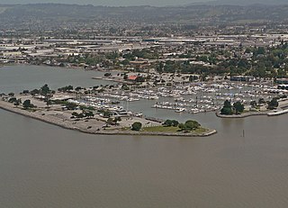
San Lorenzo, also known as San Lorenzo Village, is a census-designated place (CDP) located in the East Bay of the San Francisco Bay Area in Alameda County, California, United States. The population was 23,452 at the 2010 census. It is an unincorporated community, located at the banks of San Lorenzo Creek. It was originally named Squattersville in 1851, but later renamed to San Lorenzo.
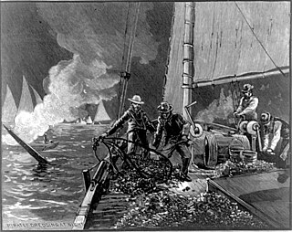
Oyster pirate is a name given to persons who engage in the poaching of oysters. It was a term that became popular on both the west and east coasts of the United States in the nineteenth century.

El Camino Real, sometimes associated with Calle Real, usually refers to the 600-mile (965-kilometer) road connecting the 21 Spanish missions in California, along with a number of sub-missions, four presidios, and three pueblos, stretching at its southern end from the San Diego area Mission San Diego de Alcalá, all of the way up to the trail's northern terminus at Mission San Francisco Solano in Sonoma, just above San Francisco Bay.

The Native Sons of the Golden West is a fraternal service organization founded in 1875, limited to native born Californians and dedicated to historic preservation, documentation of historic structures and places in the state, the placement of historic plaques and other charitable functions within California. In 1890 they placed the first historical marker in the state to honor the discovery of gold which gave rise to the state nickname "Golden State" and "Golden West." Former U.S. President Richard M. Nixon and former Chief Justice of the United States Earl Warren were both past presidents of the NSGW.

Humboldt Bay is a natural bay and a multi-basin, bar-built coastal lagoon located on the rugged North Coast of California, entirely within Humboldt County. It is the largest protected body of water on the West Coast between San Francisco Bay and Puget Sound, the second largest enclosed bay in California, and the largest port between San Francisco and Coos Bay, Oregon. The largest city adjoining the bay is Eureka, the regional center and county seat of Humboldt County, followed by the town of Arcata. These primary cities together with adjoining unincorporated communities and several small towns comprise a Humboldt Bay Area total population of nearly 80,000 people, which accounts for nearly 60% of the population of Humboldt County. In addition to being home to more than 100 plant species, 300 invertebrate species, 100 fish species, and 200 bird species, the bay and its complex system of marshes and grasses support hundreds of thousands of migrating and local shore birds. Commercially, this second largest estuary in California houses the largest oyster production operations on the West Coast, producing more than half of all oysters farmed in California.

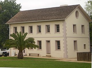
El Presidio Real de Santa Bárbara, also known as the Royal Presidio of Santa Barbara, is a former military installation in Santa Barbara, California, USA. The presidio was built by Spain in 1782, with the mission of defending the Second Military District in California. In modern times, the Presidio serves as a significant tourist attraction, museum and an active archaeological site as part of El Presidio de Santa Barbara State Historic Park.

Rancho San Antonio, also known as the Peralta Grant, was a 44,800-acre (181 km2) land grant by Governor Pablo Vicente de Solá, the last Spanish governor of California, to Don Luís María Peralta, a sergeant in the Spanish Army and later, commissioner of the Pueblo of San José, in recognition of his forty years of service. The grant, issued on August 3, 1820, embraced the sites of the cities of San Leandro, Oakland, Alameda, Emeryville, Piedmont, Berkeley, and Albany.
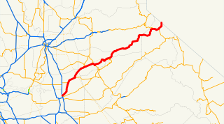
State Route 88, also known as the Carson Pass Highway, is a state highway in the U.S. state of California. It travels in an east–west direction from Stockton in the San Joaquin Valley, crossing the Sierra Nevada at Carson Pass, and ending at the Nevada state line, whereupon it becomes Nevada State Route 88, eventually terminating at U.S. Route 395.

Mormon Island was once a mining town, which had an abundance of Mormon immigrants seeking gold in the American River during the California Gold Rush. Its site is in present-day Sacramento County, California.

San Leandro Creek is a 21.7-mile-long (34.9 km) year-round natural stream in the Oakland Hills, in Alameda County and Contra Costa County of the East Bay in northern California.

San Mateo Creek is a perennial stream whose watershed includes Crystal Springs Reservoir, for which it is the only natural outlet after passing Crystal Springs Dam.
Los Encinos State Historic Park is a state park unit of California, preserving buildings of Rancho Los Encinos. The park is located near the corner of Balboa and Ventura Boulevards in Encino, California, in the San Fernando Valley. The rancho includes the original nine-room de la Ossa Adobe, the two-story limestone Garnier building, a blacksmith shop, a natural spring, and a pond. The 4.7-acre (1.9 ha) site was established as a California state park in 1949.

José Joaquín Estudillo was a Californio politician and landowner, who served as second alcalde of Yerba Buena, California, and whose land holdings, known as Rancho San Leandro, formed the basis of the city of San Leandro.
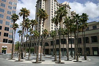
The Circle of Palms Plaza is located in downtown San Jose, California. It is composed of a ring of palm trees encircling a California State Seal, and designates the California Historical Marker 461, the site of California's first state capital from 1849-1851.
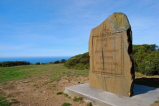
The San Francisco Bay Discovery Site is a marker commemorating the first recorded European sighting of San Francisco Bay. In 1769, the Portola expedition traveled north by land from San Diego, seeking to establish a base at the Port of Monterey described by Sebastian Vizcaino in 1602. When they reached Monterey, however, they were not sure it was the right place and decided to continue north. The party reached San Pedro Creek on October 31 and camped there for four nights, while scouts led by José Francisco Ortega climbed Sweeney Ridge, where they could see over the ridge toward the east, and so became the first Europeans to see San Francisco Bay on November 1.

Burnt Wagons is a former settlement in Inyo County, California. It was located in Death Valley 7 miles (11 km) northwest of Death Valley Junction. The name recalls the emigrants of 1849 who abandoned and burnt their wagons at the site. The site is now registered as California Historical Landmark #441. The monument's plaque reads:
BURNED WAGONS POINT Near this monument, the Jayhawker group of Death Valley Forty-Niners, gold seekers from Middle West, who entered Death Valley in 1849 seeking short route to the mines of central California, burned their wagons, dried the meat of some oxen and, with surviving animals, struggled westward on foot.
STATE REGISTERED LANDMARK NO.441
Marker placed by California Centennials Commission.
Base furnished by Death Valley '49ers, Inc.
Dedicated December 3rd, 1949

Rancho Temescal was a Mexican land grant in present-day Temescal Valley in Riverside County, California, granted by Governor José María de Echeandía in 1828 to Leandro Serrano.

The Camino of Rancho San Antonio is a former road that was located in Alameda County, California. The camino originally reached from Fruitvale to Mission San José. It eventually expanded to travel from the Temescal area of Oakland to San Pablo.

Casa de Estudillo or the Estudillo Home was a 19th-century adobe house, located in San Leandro, Alameda County, California,.