Marincello

Last updated
Current map showing where Marincello was to be built. Marincellomap.jpg
Current map showing where Marincello was to be built.

Marincello was a failed development project in Marin County, California that would have put a planned community atop the Marin Headlands, overlooking the Golden Gate. Its upheaval set the precedent for Marin County's rigid anti-development stance and push for open space.

Contents

History

Pre-Marincello years

Looking south from the Marin Headlands. Marin headlands (164007076).jpg
Looking south from the Marin Headlands.

The land making up the Marin Headlands was purchased by the US military in 1851, shortly after California became a state, for the installation of coastal defense guns. Other than building Forts Barry, Baker, and Cronkhite, and planting trees and vegetation to camouflage the forts from attack, the Marin Headlands was left in its native form. Its unique topography helped serve its purpose for the Army. [1]

By the 1950s, the military installations were becoming obsolete and the government started to look into future plans for the land. Environmentalists urged the military to give the land to the Department of Parks and Recreation to preserve its native and open quality. They also lobbied to make the forts a historic area and part of a Marin Headlands State Park.

Sale of the land

By the 1960s, the rise of the suburb was in full effect in the United States, and it looked like the pristine land atop the Marin Headlands (only minutes away from San Francisco) would prove no different. A developer from Bridgeport, Connecticut named Thomas Frouge came across the area and immediately had grand visions for the land, writing “It is probably the most beautiful location in the United States for a new community." [1] With help from Gulf Oil, he purchased the 2,138 acres (9 km2) of land and made immediate plans for his new planned community to be called "Marincello."

Marincello was originally conceived to house 20,000–30,000 people in 50 apartment towers, as well as hundreds of homes and townhouses. There would also be a mall and a grand hotel at the highest point of the headlands. [2]

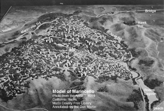
A 3D model and proposed drawings were quickly created to start a sales pitch for the houses and apartments in this new city. These demonstrated how this native land was to be built upon in an unprecedented scale for Marin County. However, Frouge promised that Marincello would be a carefully planned city and would not fall siege to the mistakes of other bloated suburbs around the country. He also noted how the houses and apartments would be built with an "open-space" architecture in mind and would effortlessly blend into the unique landscape.

Many preservationists and Marin County leaders did not see it this way. Already worried about the diminishing quality of life and the growing amount of development in the county, Marincello was looked at as the last straw that would lead to endless amounts of development around the area.

A small group of activists called the Golden Gate Headlands Committee challenged the pending approval of the project. They submitted a 6,000-name petition to the Board of Supervisors. It was met with a blind eye. A second submission of a petition was invalidated, as the county threw out 300 of the signatures and moved on. [3]

Many local newspapers published articles supporting the grand city, including one from the San Francisco Examiner reporting the plan "could not be sooner nor could the site be better chosen". [4]

They believed that Frouge's development would draw attention away from other open spaces in Marin that other developers were eyeing to build upon, including the untouched Marin seashore area. In a 1965 article, the Pacific Sun wrote that Thomas Frouge's city "will be a showcase, which will point the way to preservation of the clear and open areas essential and unique in Marin.” [1]

Present day location of Marincello gates in comparison to how it looked in the late-1960's. Marincello Gates Present Day.jpeg
Present day location of Marincello gates in comparison to how it looked in the late-1960's.

The green light

In November 1965 the County of Marin officially approved Frouge's plan and Marincello got the green light for development. Large gates were immediately built at the base of Tennessee Valley that boldly marked the entrance for the to-be-built city. Bulldozers carved a large, five-lane boulevard up the mountain that was to be one of Marincello's main streets in and out of the community. [5] These were all signs that the building of the metropolis was now well on its way, and no one could stop it now. [6]

Even before Marin Supervisors approved the Marincello plan in November 1965, legal red tape started to slowly encompass the project. In June 1965, Frouge was sued for misappropriation and false representation of a proposed street entrance to Marincello that trespassed upon private property of existing homeowners. This entrance was off Wolfback Ridge Road (from the Spencer Avenue exit), and was very important to the value of the city since it allowed easy access to US-101 and the Golden Gate Bridge from Marincello. Obviously, this small residential street that served fewer than ten houses would be deluged with commuter traffic. A preliminary injunction was issued in favor of the homeowners. [7]

By 1966, the budget for Marincello started to balloon from its original 20 year/$250 million pricetag. The executives of Gulf Oil started to doubt Thomas Frouge and the Gulf Oil Land Development Division, which was funding the project. Infighting within the company ensued, as well as a legal fallout between Frouge and Gulf Oil. In 1967, construction on the site came to a standstill.

This allowed Douglas Ferguson, Bob Praetzel, and Marty Rosen (three lawyers who were already actively following the development and enraged by the legal shortcuts taken by Frouge and his associates to accelerate the construction) to step in and file the most threatening lawsuit to face Marincello. [8]

Representing the City of Sausalito, they filed a lawsuit against Marin County, Frouge, and Gulf Oil, stating that Marincello was improperly zoned back in 1964 and allowed the public only six days to review the zoning instead the legal ten days. This would normally be an insignificant technicality for such a huge project. However, the lawsuit led to discovery of many additional inaccuracies in the Zoning Outlines (including a hastily laid-out plan for an industrial zone within the community) that the County of Marin had approved in 1965. [9]

By 1970, Frouge and Gulf Oil made amends (although Thomas Frouge himself had died at the age of 54 in early January 1969) and were finally about to get their overdue project back on track. However, that same year they were dealt a crushing blow. The court ruled that the entire project was improperly zoned and they would have to throw out their plans and submit brand new ones from scratch. Finally, the day after the court's ruling, the Board of Supervisors of Marin announced that they would no longer support the project. [10]

Marincello dies

In the late 1960s, the government was conducting a study about creating a national park surrounding the Golden Gate. It was originally conceived to include Alcatraz and the Presidio. Soon, it was realized that the Marin Headlands was a crucial area to complete this national park. Huey Johnson, western director of The Nature Conservancy, met with the Gulf Oil Corporation about selling this valuable land to the park service in early 1970. After Gulf Oil lost their lawsuit, this finally became an attractive option. In 1972, the land was sold to the Nature Conservancy for $6.5 million and then transferred to the newly formed Golden Gate National Recreation Area. [11] The Marincello project was finished, before any buildings could even be put up. In 1976, the Marincello gates at the base of Tennessee Valley, the only remaining architectural evidence of the development, were torn down and removed. [3]

Marincello today

The former main boulevard now stands as the "Marincello Trail." MarincelloTrail.jpg
The former main boulevard now stands as the "Marincello Trail."

Although the Marin Headlands currently sits among thousands of acres of virtually untouched and protected open land, some remnants of the 1960s development project still exist. The main boulevard that was built upon the Northwest portion of the area still remains as a dirt road. It is now a popular hiking, biking, and horse-back riding trail, properly named "Marincello Trail." The trail connects to other trails at the top of the Headlands that would have been roads and streets for the planned community. [12]

Rodeo Ave "Exit to Nowhere" Rodeo drive exit.jpg
Rodeo Ave "Exit to Nowhere"

Off Southbound US-101, there is an exit for Rodeo Ave that leads nowhere. It consists of a short highway off-ramp that leads to another dirt road—currently gated to restrict automobile traffic. If Marincello had been built, this dirt road would have been upgraded to a main boulevard to carry traffic in and out of Marincello. Instead, it also became a trail, accessible by foot only, that intersects with the Marincello Trail at the top of the hill.

Today, the Headlands make up part of the Golden Gate National Recreation Area, which at 16 million visitors a year, is one of the country's most popular National Park Service areas. [13]

In 1972, three of the people responsible for blocking the development, Huey Johnson, Douglas Ferguson, and Martin Rosen, founded The Trust for Public Land, an organization dedicated to the creation of parks and protected lands across the United States.

Notes

Coordinates: 37°51′02″N122°31′08″W / 37.85056°N 122.51889°W / 37.85056; -122.51889

Related Research Articles

Richmond, California City in Contra Costa County, California US

Richmond is a city in western Contra Costa County, California, United States. The city was incorporated on August 7, 1905, and has a city council. Located in the San Francisco Bay Area's East Bay region, Richmond borders San Pablo, Albany, El Cerrito and Pinole in addition to the unincorporated communities of North Richmond, Hasford Heights, Kensington, El Sobrante, Bayview-Montalvin Manor, Tara Hills, and East Richmond Heights, and for a short distance San Francisco on Red Rock Island in the San Francisco Bay. Richmond is one of two cities, the other being San Rafael, that sits on the shores of both San Francisco Bay and San Pablo Bay.

Tiburon, California Town in California in the United States

Tiburon is an incorporated town in Marin County, California. It is located on the Tiburon Peninsula, which reaches south into the San Francisco Bay. The smaller city of Belvedere occupies the southwest part of the peninsula and is contiguous with Tiburon. Tiburon is bordered by Corte Madera to the north and Mill Valley to the west, but is otherwise mostly surrounded by the Bay. Besides Belvedere and Tiburon, much of the peninsula is unincorporated, including portions of the north side and the communities of Strawberry and Paradise Cay.

Clear Lake City (Greater Houston) Housing development in Texas, United States

Clear Lake City is a master-planned community located in southeast Harris County, Texas, within the Bay Area of Greater Houston. It is the second-largest master-planned community in Houston – behind Kingwood. The majority of the community lies in the corporate limits of Houston, while a northern portion is in the city limits of Pasadena and a small eastern portion within the city limits of Taylor Lake Village.

Point Reyes National Seashore Park preserve in California, United States

Point Reyes National Seashore is a 71,028-acre (287.44 km2) park preserve located on the Point Reyes Peninsula in Marin County, California. As a national seashore, it is maintained by the US National Park Service as an important nature preserve. Some existing agricultural uses are allowed to continue within the park. Clem Miller, a US Congressman from Marin County wrote and introduced the bill for the establishment of Point Reyes National Seashore in 1962 to protect the peninsula from development which was proposed at the time for the slopes above Drake's Bay. All of the park's beaches were listed as the cleanest in the state in 2010.

Marin Headlands Southernmost peninsula of the Marin Peninsula in California, United States

The Marin Headlands is a hilly peninsula at the southernmost end of Marin County, California, United States, located just north of San Francisco across the Golden Gate Bridge, which connects the two counties and peninsulas. The entire area is part of the Golden Gate National Recreation Area. The Headlands are famous for their views of the Bay Area, especially of the Golden Gate Bridge.

Glen Canyon Park

Glen Canyon Park is a city park in San Francisco, California. It occupies about 70 acres (28 ha) along a deep canyon adjacent to the Glen Park, Diamond Heights, and Miraloma Park neighborhoods. O'Shaughnessy Hollow is a rugged, undeveloped 3.6 acres (1.5 ha) tract of parkland that lies immediately to the west and may be considered an extension of Glen Canyon Park.

Picayune Strand State Forest

Picayune Strand State Forest is one of 37 state forests in Florida managed by the Florida Forest Service. The 78,000-acre forest consists primarily of cypress swamps, wet pine flatwoods and wet prairies. It also features a grid of closed roads over part of it, left over from its previous land development schemes.

Milagra Ridge

Milagra Ridge is a 275-acre (111 ha) open space park that is an isolated island ecosystem, located about 7 miles (11 km) south of San Francisco, between the cities of Pacifica and Daly City. It was first inhabited by the Ohlone indigenous people, and was later claimed by Spanish settlers and Mexican ranchers.

Golden Gate National Recreation Area U.S. National Recreation Area surrounding San Francisco Bay Area

The Golden Gate National Recreation Area (GGNRA) is a U.S. National Recreation Area protecting 82,116 acres (33,231 ha) of ecologically and historically significant landscapes surrounding the San Francisco Bay Area. Much of the park is land formerly used by the United States Army. GGNRA is managed by the National Park Service and is the most visited unit of the National Park system in the United States, with more than 15 million visitors a year. It is also one of the largest urban parks in the world, with a size two-and-a-half times that of the consolidated city and county of San Francisco.

U.S. Route 101 (US 101) is a major north–south United States Numbered Highway, stretching from Los Angeles, California to Tumwater, Washington. The California portion of US 101 is one of the last remaining and longest U.S. Routes still active in the state, and the longest highway of any kind in California. US 101 was also one of the original national routes established in 1926. Significant portions of US 101 between the Los Angeles area and the San Francisco Bay Area follow El Camino Real, the commemorative route connecting the former Alta California's 21 missions.

Canal Area, San Rafael, California

The Canal Area comprises two neighborhoods of San Rafael, California, designated by the city as the "Canal Waterfront" and the "Canal." The Canal Area is bounded on the east by San Francisco Bay, on the north by the San Rafael Canal and on the south and west by Highways 101 and I-580 and by San Quentin Ridge. Land use is split almost evenly between residential and non-residential (commercial/industrial) uses. The Canal Area provides a substantial portion of the low-income housing in Marin County, one of the most affluent counties in the United States, along with Marin City. It is also the location of transportation and waste management facilities serving Marin County and the North Bay.

Fort Baker Former US Army base on the Golden Gate

Fort Baker is one of the components of California's Golden Gate National Recreation Area. The Fort, which borders the City of Sausalito in Marin County and is connected to San Francisco by the Golden Gate Bridge, served as an Army post until the mid-1990s, when the headquarters of the 91st Division moved to Parks Reserve Forces Training Area. It is located opposite Fort Point at the entrance to the San Francisco Bay.

Mission blue butterfly Subspecies of butterfly

The Mission blue is a blue or lycaenid butterfly subspecies native to the San Francisco Bay Area of the United States. The butterfly has been declared as endangered by the US federal government. It is a subspecies of Boisduval's blue.

Mission blue butterfly habitat conservation

The U.S. Fish and Wildlife Service (USFWS) has a number of programs aimed at Mission blue butterfly habitat conservation, which include lands traditionally inhabited by the Mission blue butterfly, an endangered species. A recovery plan, drawn up by the U.S. Fish and Wildlife Service in 1984, outlined the need to protect Mission blue habitat and to repair habitat damaged by urbanization, off highway vehicle traffic, and invasion by exotic, non-native plants. An example of the type of work being done by governmental and citizen agencies can be found at the Marin Headlands in the Golden Gate National Recreation Area. In addition, regular wildfires have opened new habitat conservation opportunities as well as damaging existing ones.

Founded in 1981, the Golden Gate National Parks Conservancy is a nonprofit cooperating association that supports park stewardship and conservation in the Golden Gate National Recreation Area—the most visited national park in the U.S.

Point Richmond Historic District Historic district in California, United States

The Point Richmond Historic District is the downtown area of Point Richmond in Richmond, California, and is on the National Register of Historic Places.

Headlands Center for the Arts

Headlands Center for the Arts hosts an internationally recognized artist-in-residence program, and interdisciplinary public programs. It is situated in a campus of artist-renovated military buildings in the Marin Headlands, in Marin County, California.

Caspar Headlands State Beach is a protected beach in the state park system of California, United States. It is located in Northern California in Mendocino County near the village of Caspar. The 75-acre (30 ha) park was established in 1972.

Valencia, California Community in Los Angeles County, California, United States

Valencia is an unincorporated community in northwestern Los Angeles County, California. This area, with major commercial and industrial parks, straddles State Route 126 and the Santa Clara River.

Tennessee Valley, California

The Tennessee Valley is a small, undeveloped part of Marin County, near Mill Valley. Historically home to ranches and threatened with the development of a new city, the valley was incorporated into the Golden Gate National Recreation Area in 1972, with additional sections added to the park in 1974. The park contains horse stables, a native-plant nursery, and numerous trails for hiking, biking, and horse riding, including a 1.7-mile, handicap-accessible trail that leads to Tennessee Cove and its beach.