San Francisco Bay Area

Last updated

San Francisco Bay Area
California Bay Area county map.svg
Location of the Bay Area within California.
  The nine-county Bay Area.
  Additional counties in the larger thirteen-county combined statistical area.
CountryUnited States
State California
Subregions
Counties
Core cities Oakland
San Francisco
San Jose
Other municipalities
Area
[1]
  Nine-county6,966 sq mi (18,040 km2)
  San Jose-San Francisco-Oakland (CSA)10,191 sq mi (26,390 km2)
Highest elevation4,360 ft (1,330 m)
Lowest elevation−13 ft (−4 m)
Population
 (2020)
  Nine-county
7.76 million [4]
  San Jose-San Francisco-Oakland (CSA)
9.71 million [4]
GDP
  Nine-county$729.105 billion (2022)
  San Jose-San Francisco-Oakland (CSA)$1.383 trillion (2022)
Time zone UTC−08:00 (Pacific)
  Summer (DST) UTC−07:00 (PDT)
Area codes 408/669, 415/628, 510/341, 650, 707, 925 [7]
Website bayareametro.gov

The San Francisco Bay Area, commonly known as the Bay Area, is a region of California. [8] The Association of Bay Area Governments defines the Bay Area as including the nine counties that border the estuaries of San Francisco, San Pablo, and Suisun: Alameda, Contra Costa, Marin, Napa, San Mateo, Santa Clara, Solano, Sonoma, and San Francisco. Other definitions may be either smaller or larger, and may include neighboring counties such as the Central Coast counties of Santa Cruz, San Benito, and Monterey, or the Central Valley counties of San Joaquin, Merced, and Stanislaus. [9] The Bay Area is known for its natural beauty, progressive politics, prominent universities, technology companies, and affluence. The Bay Area contains many cities, towns, airports, and associated regional, state, and national parks, connected by a complex multimodal transportation network.

Contents

The earliest archaeological evidence of human settlements in the Bay Area dates back to 8000–10,000 BC. The oral tradition of the Ohlone and Miwok people suggests they have been living in the Bay Area for several hundreds if not thousands of years. [10] [11] The Spanish empire claimed the area beginning in the early period of Spanish colonization of the Americas. The earliest Spanish exploration of the Bay Area took place in 1769. The Mexican government controlled the area from 1821 until the 1848 Treaty of Guadalupe Hidalgo. Also in 1848, James W. Marshall discovered gold in nearby mountains, resulting in explosive immigration to the area and the precipitous decline of the Native population. The California Gold Rush brought rapid growth to San Francisco. [12] California was admitted as the 31st state in 1850. A major earthquake and fire leveled much of San Francisco in 1906. During World War II, the Bay Area played a major role in America's war effort in the Asiatic-Pacific Theater, with the San Francisco Port of Embarkation, of which Fort Mason was one of 14 installations and location of the headquarters, acting as a primary embarkation point for American forces. Since then, the Bay Area has experienced numerous political, cultural, and artistic movements, developing unique local genres in music and art and establishing itself as a hotbed of progressive politics. Economically, the post-war Bay Area saw large growth in the financial and technology industries, creating an economy with a gross domestic product of over $700 billion. In 2018 it was home to the third-highest concentration of Fortune 500 companies in the United States. [13] [14]

The Bay Area is home to approximately 7.52 million people. [15] The larger federal classification, the combined statistical area of the region which includes 13 counties, [9] is the second-largest in California—after the Greater Los Angeles area—and the fifth-largest in the United States, with over 9 million people. [16] The Bay Area's population is ethnically diverse: roughly three-fifths of the region's residents are Hispanic, Asian, African American, or Pacific Islander, all of whom have a significant presence throughout the region. Most of the remaining two-fifths of the population is non-Hispanic White American. The most populous cities of the Bay Area are Oakland, San Francisco, and San Jose, the latter of which in 2022 had population of 971,233, making it the 12th-most populous in the United States. [17] [18]

Despite its urban character, the San Francisco Bay is one of California's most ecologically sensitive habitats, providing important ecosystem services such as filtering the pollutants and sediments from rivers and supporting a number of endangered species. In addition, the Bay Area is known for its stands of coast redwoods, many of which are protected in state and county parks. The region is additionally known for the complexity of its landforms, the result of millions of years of tectonic plate movements. Because the Bay Area is crossed by 6 major earthquake faults, the region is particularly exposed to hazards presented by large earthquakes. The climate is temperate and conducive to outdoor recreational and athletic activities such as hiking, running, and cycling. The Bay Area is host to 6 professional sports teams and is a cultural center for music, theater, and the arts. It is also host to numerous higher education institutions, including research universities such as Stanford University and the University of California, Berkeley. Home to 101 municipalities and 9 counties, governance in the Bay Area involves numerous local and regional jurisdictions, often with broad and overlapping responsibilities.

History

The Ohlone, an indigenous Californian people, have lived in the Bay Area for thousands of years. Charles Christian Nahl - Indian Family on San Francisco Bay.jpg
The Ohlone, an indigenous Californian people, have lived in the Bay Area for thousands of years.

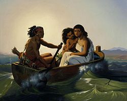
The Coyote Hills Shell Mound, the earliest known archaeological evidence of human habitation of the Bay Area estuaries, dates to around 10,000 BCE, with evidence pointing to even earlier settlement in Point Reyes in Marin County. [19] It has been conjectured that the people living in the Bay Area at the time of first European contact were descended from Siberian tribes who arrived at around 1,000 BCE by sailing over the Arctic Ocean and following the salmon migration. [20] However the current academic consensus is compatible with the oral tradition of the Ohlone and Miwok peoples, which suggests they have been living in the Bay Area for several hundreds if not thousands of years. [10] [11]

At the time of colonization, the Ohlone peoples in the Bay Area primarily lived on the San Francisco Peninsula, in the South Bay and in the East Bay, and the Miwok primarily lived in the North Bay, northern East Bay, and Central Valley. Ohlone villages were spread across the Peninsula, East Bay, South Bay, as well as further south into the Monterey Bay area. [21] There were eight major divisions of Ohlone people, four of which were based in the Bay Area: the Karkin of the Carquinez Strait, the Chochenyo of the East Bay, the Ramaytush of the San Francisco Peninsula, and the Tamien of the South Bay. The Miwok had two major groups in the Bay Area: the Bay Miwok of Contra Costa and the Coast Miwok of Marin and Sonoma.

In 1542, Juan Rodríguez Cabrillo explored the Pacific coast near the Bay Area though the expedition did not see the Golden Gate or the estuaries, likely due to fog. Sir Francis Drake became the first European to land in the area and claim it in June 1579, when he landed at Drakes Bay near Point Reyes. Even though he claimed the region for Queen Elizabeth I as Nova Albion or New Albion, the English made no immediate follow up to the claim. [22] [23] [24]

In 1595, Philip II of Spain tasked Sebastião Rodrigues Soromenho with mapping the west coast of the Americas. Soromenho set sail on Manila Galleon San Agustin on July 5, 1595 and in early November they reached land between Point St. George and Trinidad Head, north of the Bay Area, in the Lost Coast. The expedition followed the coast southward and on November 7 the San Agustin anchored in Drakes Bay, and claimed the region as Puerto y Bahía de San Francisco. [25] [26] [27] In late November, a storm sank the San Agustin and killed between 7 and 12 people. On December 8, 80 remaining crew members set sail on the San Buenaventura, a launch which was partially constructed en route from the Philippines. Seeking the fastest route south, the expedition sailed past the Golden Gate, arriving at Puerto de Chacala, Mexico on January 17, 1596. [28]

In 1776, Francisco Palou founded Mission San Francisco de Asis, the first Spanish settlement in the Bay Area. Mission San Francisco de Asis (Oriana Day) (cropped).jpg
In 1776, Francisco Palóu founded Mission San Francisco de Asís, the first Spanish settlement in the Bay Area.
General Vallejo reviewing Californio troops in Sonoma, during the U.S. Conquest of California in 1846 "General Vallejo Reviewing His Troops in Sonoma, 1846".jpg
General Vallejo reviewing Californio troops in Sonoma, during the U.S. Conquest of California in 1846

The Bay Area estuaries remained unknown to Europeans until members of the Portolá expedition, while trekking along the California coast, encountered it in 1769 when the Golden Gate blocked their continued journey north. [29] Several missions were founded in the Bay Area during this period. In 1806, a Spanish expedition led by Gabriel Moraga began at the Presidio, traveled south of the bay, and then east to explore the San Joaquin Valley. [30]

In 1821, Mexico gained its independence from Spain and the Bay Area became part of the Mexican province of Alta California, a period characterized by ranch life and visiting American trappers. [31] Mexico's control of the territory would be short-lived, however, and in 1846 a party of settlers occupied Sonoma Plaza and proclaimed the independence of the new Republic of California. [31] That same year, the Mexican–American War began, and American captain John Berrien Montgomery sailed the USS Portsmouth into the bay and seized San Francisco, which was then known as Yerba Buena, and raised the American flag for the first time over Portsmouth Square. [32]

The Port of San Francisco during the California Gold Rush SanFranciscoharbor1851c sharp.jpg
The Port of San Francisco during the California Gold Rush

In 1848, James W. Marshall's discovery of gold in the American River sparked the California Gold Rush, and within half a year 4,000 men were panning for gold along the river and finding $50,000 per day. [33] The promise of fabulous riches quickly led to a stampede of wealth-seekers descending on Sutter's Mill. The Bay Area's population quickly emptied out as laborers, clerks, waiters, and servants joined the rush to find gold, and California's first newspaper, The Californian , was forced to announce a temporary freeze in new issues due to labor shortages. [33] By the end of 1849, news had spread across the world and newcomers flooded into the Bay Area at a rate of one thousand per week on their way to California's interior, [33] including the first large influx of Chinese immigrants to the U.S. [34] The rush was so great that vessels were abandoned by the hundreds in San Francisco's ports as crews rushed to the goldfields. [35] The unprecedented influx of new arrivals spread the nascent government authorities thin, and the military was unable to prevent desertions. As a result, numerous vigilante groups formed to provide order, but many tasked themselves with forcibly moving or killing local Native Americans, and by the end of the Gold Rush, two thirds of the indigenous population had been killed. [36]

San Jose served as the first state capitol following the California's Admission to the Union in 1850. California's first state capitol in San Jose (c. 1850).jpg
San Jose served as the first state capitol following the California's Admission to the Union in 1850.

During this same time, a constitutional convention was called to determine California's application for statehood into the United States. After statehood was granted, the capital city moved between three cities in the Bay Area: San Jose (1849–1851), Vallejo (1851–1852), and Benicia (1852–1853) before permanently settling in Sacramento in 1854. [37] As the Gold Rush subsided, wealth generated from the endeavor led to the establishment of Wells Fargo Bank and the Bank of California, and immigrant laborers attracted by the promise of wealth transformed the demographic makeup of the region. Construction of the First transcontinental railroad from the Oakland Long Wharf attracted so many laborers from China that by 1870, eight percent of San Francisco's population was of Asian origin. [38] The completion of the railroad connected the Bay Area with the rest of the United States, established a truly national marketplace for the trade of goods, and accelerated the urbanization of the region. [39]

Damaged buildings in the aftermath of the 1906 San Francisco earthquake Post-and-Grant-Avenue-Look.jpg
Damaged buildings in the aftermath of the 1906 San Francisco earthquake

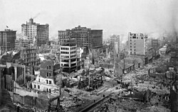
In the early morning of April 18, 1906, a large earthquake with an epicenter near the city of San Francisco hit the region. [40] Immediate casualty estimates by the U.S. Army's relief operations were 498 deaths in San Francisco, 64 deaths in Santa Rosa, and 102 in or near San Jose, for a total of about 700. More recent studies estimate the total death count to be over 3,000, with over 28,000 buildings destroyed. [41] Rebuilding efforts began immediately. Amadeo Peter Giannini, owner of the Bank of Italy (now known as the Bank of America), had managed to retrieve the money from his bank's vaults before fires broke out through the city and was the only bank with liquid funds readily available and was instrumental in loaning out funds for rebuilding efforts. [42] Congress immediately approved plans for a reservoir in Hetch Hetchy Valley in Yosemite National Park, a plan they had denied a few years earlier, which now provides drinking water for 2.4 million people in the Bay Area. By 1915, the city had been sufficiently rebuilt and advertised itself to the world during the Panama Pacific Exposition that year, although the effects of the quake hastened the loss of the region's dominant status in California to the Los Angeles metropolitan area. [42]

The United Nations was created in San Francisco in 1945, when the United Nations Charter was signed at the San Francisco Conference. Alexander Loudon, de Nederlandse ambassadeur in de Verenigde Staten, ondertekent in aanwezigheid van Charles Olke (II) van der Plas en andere leden van de Nederlandse delegatie het handvast van de Uni, KITLV 403000.tiff
The United Nations was created in San Francisco in 1945, when the United Nations Charter was signed at the San Francisco Conference.

During the 1929 stock market crash and subsequent economic depression, not a single San Francisco-based bank failed, [43] while the region attempted to spur job growth by simultaneously undertaking two large infrastructure projects: construction of the Golden Gate Bridge, which would connect San Francisco with Marin County, [44] and the Bay Bridge, which would connect San Francisco with Oakland and the East Bay. [45] After the United States joined World War II in 1941, the Bay Area became a major domestic military and naval hub, with large shipyards constructed in Sausalito and across the East Bay to build ships for the war effort. [46] The Army's San Francisco Port of Embarkation was the primary origin for Army forces shipping out to the Pacific Theater of Operations. [47] [48] That command consisted of fourteen installations including Fort Mason, the Oakland Army Base, Camp Stoneman and Fort McDowell in San Francisco Bay and the sub port of Los Angeles. [49]

After World War II, the United Nations was chartered in San Francisco, and in September 1951, the Treaty of San Francisco to re-establish peaceful relations between Japan and the Allied Powers was signed in San Francisco, entering into force a year later. [50] In the years immediately following the war, the Bay Area saw a huge wave of immigration as populations increased across the region. Between 1950 and 1960, San Francisco welcomed over 100,000 new residents, inland suburbs in the East Bay saw their populations double, Daly City's population quadrupled, and Santa Clara's population quintupled. [46]

Vietnam War draft evasion march in Oakland, led by David Harris in 1967. Police, Stop the Draft Week (cropped).jpg
Vietnam War draft evasion march in Oakland, led by David Harris in 1967.

By the early 1960s, the Bay Area and the rest of Northern California became the center of the counterculture movement. Telegraph Avenue in Berkeley and the Haight-Ashbury neighborhood in San Francisco were seen as centers of activity, [51] with the hit American pop song San Francisco (Be Sure to Wear Flowers in Your Hair) further enticing like-minded individuals to join the movement in the Bay Area and leading to the Summer of Love. [52] In the proceeding decades, the Bay Area would cement itself as a hotbed of New Left activism, student activism, opposition to the Vietnam War and other anti-war movements, the black power movement, and the gay rights movement. [51] At the same time, parts of San Mateo and Santa Clara counties began to rapidly develop from an agrarian economy into a hotbed of the high-tech industry. [53] Fred Terman, the director of a top-secret research project at Harvard University during World War II, joined the faculty at Stanford University in order to reshape the university's engineering department. His students, including David Packard and William Hewlett, would later help usher in the region's high-tech revolution. [46] In 1955, Shockley Semiconductor Laboratory opened for business in Mountain View near Stanford, and although the business venture was a financial failure, it was the first semiconductor company in the Bay Area, and the talent that it attracted to the region eventually led to a high-tech cluster of companies later known as Silicon Valley. [54]

The assassinations of George Moscone and Harvey Milk in 1978 led to the White Night riots and the abolition of diminished responsibility as a criminal defense in California. Cover of San Francisco Chronicle November 28 1978.jpg
The assassinations of George Moscone and Harvey Milk in 1978 led to the White Night riots and the abolition of diminished responsibility as a criminal defense in California.

In 1989, in the middle of a World Series game between two Bay Area baseball teams, the Loma Prieta earthquake struck and caused widespread infrastructural damage, including the failure of the Bay Bridge, a major link between San Francisco and Oakland. [55] Even so, the Bay Area's technology industry continued to expand and growth in Silicon Valley accelerated: the United States census confirmed that year that San Jose had overtaken San Francisco in terms of population. [56] The commercialization of the Internet in the middle of the decade rapidly created a speculative bubble in the high-tech economy known as the dot-com bubble. This bubble began collapsing in the early 2000s and the industry continued contracting for the next few years, nearly wiping out the market. Companies like Amazon.com and Google managed to weather the crash however, and following the industry's return to normalcy, their market value increased significantly. [57]

Even as the growth of the technology sector transformed the region's economy, progressive politics continued to guide the region's political environment. By the turn of the millennium, non-Hispanic whites, the largest ethnic group in the United States, were only half of the population in the Bay Area as immigration among minority groups accelerated. [58] During this time, the Bay Area was the center of the LGBT rights movement: in 2004, San Francisco began issuing marriage licenses to same-sex couples, a first in the United States, [59] and four years later a majority of voters in the Bay Area rejected California Proposition 8, which sought to constitutionally restrict marriage to opposite-sex couples but ultimately passed statewide. [60]

Black Lives Matter/George Floyd protests in San Jose in 2020 Black Lives Matter protest in San Jose, CA on June 7, 2020 - 0407 (cropped).jpg
Black Lives Matter/George Floyd protests in San Jose in 2020

The Bay Area was also the center of contentious protests concerning racial and economic inequality. In 2009, an African-American man named Oscar Grant was fatally shot by Bay Area Rapid Transit police officers, precipitating widespread protests across the region and even riots in Oakland. [61] His name was symbolically tied to the Occupy Oakland protests two years later that sought to fight against social and economic inequality. [62]

By August 2023, San Francisco was in such severe decline that Mayor Matt Mahan of San Jose joked that one day the region might be renamed the "San Jose Bay Area", after its largest and most prosperous city. [63]

Geography

Boundaries

A map of the Bay Area and its sub-regions, divided by counties:
North Bay
San Francisco
San Francisco Peninsula
South Bay / Santa Clara Valley
East Bay California Bay Area county map (zoom&color).svg
A map of the Bay Area and its sub-regions, divided by counties:
   North Bay
   East Bay

The borders of the San Francisco Bay Area are not officially delineated, and the unique development patterns influenced by the region's topography, as well as unusual commute patterns caused by the presence of three central cities and employment centers located in various suburban locales, has led to considerable disagreement between local and federal definitions of the area. [64] Because of this, professor of geography at the University of California, Berkeley Richard Walker claimed that "no other U.S. city-region is as definitionally challenged [as the Bay Area]." [64]

When the region began to rapidly develop during and immediately after World War II, local planners settled on a nine-county definition for the Bay Area, consisting of the counties that directly border the San Francisco, San Pablo, and Suisun estuaries: Alameda, Contra Costa, Marin, Napa, San Francisco, San Mateo, Santa Clara, Solano, and Sonoma counties. [65] Today, this definition is accepted by most local governmental agencies including San Francisco Regional Water Quality Control Board, [66] Bay Area Air Quality Management District, [67] the San Francisco Bay Restoration Authority, [68] the Metropolitan Transportation Commission, [69] and the Association of Bay Area Governments, [70] the latter two of which partner to deliver a Bay Area Census using the nine-county definition. [71]

Various U.S. Federal government agencies use definitions that differ from their local counterparts' nine-county definition. For example, the Federal Communications Commission (FCC) which regulates broadcast, cable, and satellite transmissions, includes nearby Colusa, Lake and Mendocino counties in their "San Francisco-Oakland-San Jose" media market, but excludes eastern Solano county. [72] On the other hand, the United States Office of Management and Budget, which designates metropolitan statistical areas (MSAs) and combined statistical areas (CSA) for populated regions across the country, has five MSAs which include, wholly or partially, areas within the nine-county definition, and one CSA which includes eight Bay Area counties (excluding Sonoma), but including neighboring San Benito, Santa Cruz, San Joaquin, Merced, and Stanislaus counties. [9]

The Association of Bay Area Health Officers (ABAHO), an organization that has fought local outbreaks of HIV/AIDS in 1980s and with COVID-19 pandemic and Delta cron hybrid variant (2020–22), consists of the public health officers of 9 Bay Area counties, in addition to the Central Coast counties of Santa Cruz, San Benito, and Monterey and the city of Berkeley.

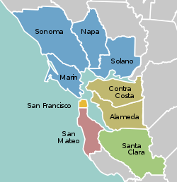
Counties in the San Jose-San Francisco-Oakland Combined Statistical Area [73]
County2022 estimate2020–22
change
2020 Population2010 Population2010–20
change
2020 Density (per sq mi) MSA
Alameda 1,628,997-3.2%1,682,3531,510,271+11.4%2,281.3San Francisco–Oakland–Berkeley
Contra Costa 1,156,966-0.8%1,165,9271,049,025+11.1%1,626.3
Marin 256,018-2.4%262,321252,409+3.9%504.1
San Francisco 808,437-7.5%873,965805,235+8.5%18,629.1
San Mateo 729,181-4.6%764,442718,451+6.4%1,704.0
San Benito 67,579+5.3%64,20955,269+16.2%46.2San Jose–Sunnyvale–Santa Clara
Santa Clara 1,870,945-3.4%1,936,2591,781,642+8.7%1,499.7
Napa 134,300-2.7%138,019136,484+1.1%184.4Napa
Solano 448,747-1.0%453,491413,344+9.7%551.8Vallejo–Fairfield
Sonoma 482,650-1.3%488,863483,878+1.0%310.3Santa Rosa–Petaluma
Merced 290,014+3.1%281,202255,793+9.9%145.1Merced
Santa Cruz 264,370-2.4%270,861262,382+3.2%608.5Santa Cruz–Watsonville
San Joaquin 793,229+1.3%779,233685,306+13.7%559.6Stockton–Lodi
Stanislaus 551,275-0.3%552,878514,453+7.5%369.6Modesto
  Bay Area counties colored red
Sonoma County was separated from the CSA in 2023. [9]

Subregions

Among locals, the nine-county Bay Area is divided into five sub-regions: the East Bay, North Bay, Peninsula, city of San Francisco, and South Bay.

The "East Bay" is the densest region of the Bay Area outside of San Francisco and includes cities and towns in Alameda and Contra Costa counties centered around Oakland. As one of the larger subregions, the East Bay includes a variety of enclaves, including the suburban Tri-Valley area and the highly urban western part of the subregion that runs alongside the bay, including Oakland. [74]

The "North Bay" includes Marin, Sonoma, Napa, and Solano counties, and is the largest and least populated subregion. The western counties of Marin and Sonoma are encased by the Pacific Ocean on the west and the bay on the east and are characterized by their mountainous and woody terrain. Sonoma and Napa counties are known internationally for their grape vineyards and wineries, and Solano County to the east, centered around Vallejo, is the fastest growing region in the Bay Area. [75]

The "Peninsula" subregion includes the cities and towns on the San Francisco Peninsula, excluding the titular city of San Francisco. Its eastern half, which runs alongside the Bay, is highly populated, while its less populated western coast traces the coastline of the Pacific Ocean and is known for its open space and hiking trails. Roughly coinciding with the borders of San Mateo County, it also includes the northwestern Santa Clara County cities of Palo Alto, Mountain View, and Los Altos. [76]

Although geographically located on the tip of the San Francisco Peninsula, the city of San Francisco is not considered part of the "Peninsula" subregion, but as a separate entity. [77] [78]

The term "South Bay" has different meanings to different groups: Writing in 1959 for the Army Corps of Engineers, the United States Department of Commerce defined the South Bay as comprising five counties, corresponding to their two-way division of the bay into north and south regions. [79] In 1989, the federal Environmental Protection Agency defined the South Bay as the northern part of Santa Clara County and the southeastern part of San Mateo County. [80] This latter definition corresponds to common usage. [81]

Climate

The North Coast near Muir Beach Northern California Coast as seen from Muir Beach Overlook.jpg
The North Coast near Muir Beach

The Bay Area is located in the warm-summer Mediterranean climate zone (Köppen Csb) that is a characteristic of California's coast, featuring mild to cool winters with occasional rainfall, and warm to hot, dry summers. [82] It is largely influenced by the cold California Current, which penetrates the natural mountainous barrier along the coast by traveling through various gaps. [83] In terms of precipitation, this means that the Bay Area has pronounced seasons. The winter season, which roughly runs between November and March, is the source of about 82% of annual precipitation in the area. In the South Bay and further inland, while the winter season is cool and mild, the summer season is characterized by warm sunny days, [83] while in San Francisco and areas closer to the Golden Gate strait, the summer season is periodically affected by fog. [84]

View of Mount Diablo beyond Lafayette Reservoir Lafayette Reservoir aerial.jpg
View of Mount Diablo beyond Lafayette Reservoir

Due to the Bay Area's diverse topographic relief (itself the result of the clashing tectonic plates), the region is home to numerous microclimates that lead to pronounced differences in climate and temperature over short distances. [82] [85] Within the city of San Francisco, natural and artificial topographical features direct the movement of wind and fog, resulting in startlingly varied climates between city blocks. Along the Golden Gate Strait, oceanic wind and fog from the Pacific Ocean are able to penetrate the mountain barriers inland into the Bay Area. [85]

During the summer, rising hot air in California's interior valleys creates a low pressure area that draws winds from the North Pacific High through the Golden Gate, which creates the city's characteristic cool winds and fog. [84] The microclimate phenomenon is most pronounced during this time, when fog penetration is at its maximum in areas near the Golden Gate strait, [85] while the South Bay and areas further inland are sunny and dry. [83]

San Bruno Mountain divides San Francisco from San Mateo County. San Bruno Mountain aerial wide (cropped).jpg
San Bruno Mountain divides San Francisco from San Mateo County.

Along the San Francisco peninsula, gaps in the Santa Cruz Mountains, one south of San Bruno Mountain and another in Crystal Springs, allow oceanic weather into the interior, causing a cooling effect for cities along the Peninsula and even as far south as San Jose. This weather pattern is also the source for delays at San Francisco International Airport. In Marin county north of the Golden Gate strait, two gaps north of Muir Woods bring cold air across the Marin Headlands, with the cooling effect reaching as far north as Santa Rosa. [85] Further inland, the East Bay receives oceanic weather that travels through the Golden Gate strait, and further diffuses that air through the Berkeley Hills, Niles Canyon and the Hayward Pass into the Livermore Valley and Altamont Pass. Here, the resulting breeze is so strong that it is home to one of the world's largest array of wind turbines. Further north, the Carquinez Strait funnels the ocean weather into the San Joaquin River Delta, causing a cooling effect in Stockton and Sacramento, so that these cities are also cooler than their Central Valley counterparts in the south. [85]

Average daily high and low temperatures in °F (°C) for selected locations in the Bay Area,
colored and sortable by average monthly temperature
CityJanFebMarAprMayJunJulAugSepOctNovDec
Fairfield [86] 55/39
(13/4)
61/42
(16/6)
66/45
(19/7)
71/47
(22/8)
78/52
(26/11)
85/56
(29/13)
90/58
(32/14)
89/57
(32/14)
86/56
(30/13)
78/51
(26/11)
65/44
(18/7)
55/39
(13/4)
Oakland [87] 58/44
(14/7)
67/47
(19/8)
64/49
(18/9)
66/50
(19/10)
69/53
(21/12)
72/55
(22/13)
72/56
(22/13)
73/58
(23/14)
74/57
(23/14)
72/54
(22/12)
65/49
(18/9)
58/45
(14/7)
San Francisco [88] 57/46
(14/8)
60/48
(16/9)
62/49
(17/9)
63/49
(17/9)
64/51
(18/11)
66/53
(19/12)
66/54
(19/12)
68/55
(20/13)
70/55
(21/13)
69/54
(21/12)
63/50
(17/10)
57/46
(14/8)
San Jose [89] 58/42
(14/6)
62/45
(17/7)
66/47
(19/8)
69/49
(21/9)
74/52
(23/11)
79/56
(26/13)
82/58
(28/14)
82/58
(28/14)
80/57
(27/14)
74/53
(23/12)
64/46
(18/8)
58/42
(14/6)
Santa Rosa [90] 59/39
(15/4)
63/41
(17/5)
67/43
(19/6)
70/45
(21/7)
75/48
(24/9)
80/52
(27/11)
82/52
(28/11)
83/53
(28/12)
83/52
(28/11)
78/48
(26/9)
67/43
(19/6)
59/39
(15/4)

Ecology

Coyote in the Arastradero Preserve Arastradero Coyote (2079329003).jpg
Coyote in the Arastradero Preserve

Marine wildlife

The Bay Area is home to a diverse array of wildlife and, along with the connected San Joaquin River Delta represents one of California's most important ecological habitats. [91] California's Dungeness crab, Pacific halibut, and the California scorpionfish are all significant components of the bay's fisheries. [92] The bay's salt marshes now represent most of California's remaining salt marsh and support a number of endangered species and provide key ecosystem services such as filtering pollutants and sediments from the rivers. [93] Most famously, the bay is a key link in the Pacific Flyway and with millions of shorebirds annually visiting the bay shallows as a refuge, is the most important component of the flyway south of Alaska. [94] Many endangered species of birds are also found here: the California least tern, the California clapper rail, the snowy egret, and the black crowned night heron. [95]

River otters sunning on rocks in the Inner Harbor of Richmond River otter Richmond Marina Scott Campbell July 29, 2010.jpg
River otters sunning on rocks in the Inner Harbor of Richmond

There is also a significant diversity of salmonids present in the bay. Steelhead populations in California have dramatically declined due to human and natural causes; in the Bay Area, all naturally spawned anadromous steelhead populations below natural and manmade impassable barriers in California streams from the Russian River to Aptos Creek, and the drainages of San Francisco, San Pablo, and Suisun Bays are listed as threatened under the Federal Endangered Species Act. [96] The Central California Coast coho salmon population is the most endangered of the many troubled salmon populations on the west coast of the United States, including populations residing in tributaries to the San Francisco Bay. [97] California Coast Chinook salmon were historically native to the Guadalupe River in San Francisco Bay, and Chinook salmon runs persist today in the Guadalupe River, Coyote Creek, Napa River, and Walnut Creek. [98] Industrial, mining, and other uses of mercury have resulted in a widespread distribution of that poisonous metal in the bay, with uptake in the bay's phytoplankton and contamination of its sportfish. [99]

Martinez beaver in Alhambra Creek Beaver Yearling Grooming Alhambra Creek 2008.jpg
Martinez beaver in Alhambra Creek

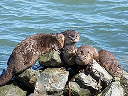
Aquatic mammals are also present in the bay. Before 1825, Spanish, French, English, Russians and Americans were drawn to the Bay Area to harvest prodigious quantities of beaver, river otter, marten, fisher, mink, fox, weasel, harbor and fur seals and sea otter. This early fur trade, known as the California Fur Rush, was more than any other single factor, responsible for opening up the West and the San Francisco Bay Area, in particular, to world trade. [100] By 1817 sea otter in the area were practically eliminated. [101] Since then, the California golden beaver re-established a presence in Alhambra Creek, followed by the Napa River and Sonoma Creek in the north, and the Guadalupe River and Coyote Creek in the south. [102] The North American river otter which was first reported in Redwood Creek at Muir Beach in 1996, [103] has since been spotted in the North Bay's Corte Madera Creek, the South Bay's Coyote Creek, [104] as well as in 2010 in San Francisco Bay itself at the Richmond Marina. Other mammals include the internationally famous sea lions who began inhabiting San Francisco's Pier 39 after the 1989 Loma Prieta earthquake [105] and the locally famous Humphrey the Whale, a humpback whale who entered San Francisco Bay twice on errant migrations in the late 1980s and early 1990s. [106] Bottlenose dolphins and harbor porpoises have recently returned to the bay, having been absent for many decades. Historically, this was the northern extent of their warm-water species range. [107]

Birds

Black-necked stilts in flight at the Baylands Nature Preserve Himantopus mexicanus -San Francisco Bay, California, USA -flying-8.jpg
Black-necked stilts in flight at the Baylands Nature Preserve

In addition to the many species of marine birds that can be seen in the Bay Area, many other species of birds make the Bay Area their home, making the region a popular destination for birdwatching. [108] Many birds are listed as endangered species despite once being common in the region.

Western burrowing owls were originally listed as a species of special concern by the California Department of Fish and Game in 1979. California's population declined 60% from the 1980s to the early 1990s, and continues to decline at roughly 8% per year. [109] A 1992–93 survey reported little to no breeding burrowing owls in most of the western counties in the Bay Area, leaving only Alameda, Contra Costa, and Solano counties as remnants of a once large breeding range. [110]

A burrowing owl in Antioch Burrowing Owl in Antioch 2009.jpg
A burrowing owl in Antioch

Bald eagles were once common in the Bay Area, but habitat destruction and thinning of eggs from DDT poisoning reduced the California state population to 35 nesting pairs. Bald eagles disappeared from the Bay Area in 1915, and only began returning in recent years. [111] In the 1980s an effort to re-introduce the species to the area began with the Santa Cruz Predatory Bird Research Group and the San Francisco Zoo importing birds and eggs from Vancouver Island and northeastern California, [112] and there are now nineteen nesting couples in eight of the Bay Area's nine counties. [111] Other once absent species that have returned to the Bay Area include Swainson's hawk, white tailed kite, and the osprey. [111]

Heermann's gulls with a double crested cormorant and a Western gull at Point Reyes National Seashore Bay Area (22533598484).jpg
Heermann's gulls with a double crested cormorant and a Western gull at Point Reyes National Seashore

In 1927, zoologist Joseph Grinnell wrote that osprey were only rare visitors to the San Francisco Bay Area, although he noted records of one or two used nests in the broken tops of redwood trees along the Russian River. [113] In 1989, the southern breeding range of the osprey in the Bay Area was Kent Lake, although osprey were noted to be extending their range further south in the Central Valley and the Sierra Nevada. [114] In 2014, a Bay Area-wide survey found osprey had extended their breeding range southward with nesting sites as far south as Hunters Point in San Francisco on the west side and Hayward on the east side, while further studies have found nesting sites as far south as the Los Gatos Creek watershed, indicating that the nesting range now includes the entire length of San Francisco Bay. [115] Most nests were built on man-made structures close to areas of human disturbance, likely due to lack of mature trees near the Bay. [116] The wild turkey population was introduced in the 1960s by state game officials, and by 2015 have become a common sight in East Bay communities. [117]

Geology and landforms

Satellite photo of the Bay Area taken in March 2019. The gray areas are signs of urbanization and represent the most populated areas. Bay Area by Sentinel-2, 2019-03-11 (small version).jpg
Satellite photo of the Bay Area taken in March 2019. The gray areas are signs of urbanization and represent the most populated areas.

The Bay Area is well known for the complexity of its landforms that are the result of the forces of plate tectonics acting over of millions of years, since the region is located in the middle of a meeting point between two plates. [118] Nine out of eleven distinct assemblages have been identified in a single county, Alameda. [119] Diverse assemblages adjoin in complex arrangements due to offsets along the many faults (both active and stable) in the area. As a consequence, many types of rock and soil are found in the region. The oldest rocks are metamorphic rocks that are associated with granite in the Salinian Block west of the San Andreas fault. These were formed from sedimentary rocks of sandstone, limestone, and shale in uplifted seabeds. [120] Volcanic deposits also exist in the Bay Area, left behind by the movement of the San Andreas fault, whose movement sliced a subduction plate and allowed magma to briefly flow to the surface. [121]

The region has considerable vertical relief in its landscapes that are not in the alluvial plains leading to the bay or in inland valleys. The topography, and geologic history, of the Bay Area can largely be attributed to the compressive forces between the Pacific Plate and the North American plate. [122]

A map displaying each of the seven major fault lines in the Bay Area and the probability of an M6.7 or higher earthquake occurring between 2003 and 2032 Eq-prob.jpg
A map displaying each of the seven major fault lines in the Bay Area and the probability of an M6.7 or higher earthquake occurring between 2003 and 2032

The three major ridge structures in the Bay Area, part of the Pacific Coast Range, are all roughly parallel to the major faults. The Santa Cruz Mountains along the San Francisco Peninsula and the Marin Hills in Marin County follow the San Andreas fault, The Berkeley Hills, San Leandro Hills and their southern ridgeline extension through Mission Peak roughly follow the Hayward fault, and the Diablo Range, which includes Mount Diablo and Mount Hamilton and runs along the Calaveras fault. [123]

In total, the Bay Area is traversed by seven major fault systems with hundreds of related faults, all of which are stressed by the relative motion between the Pacific Plate and the North American Plate or by compressive stresses between these plates. The fault systems include the Hayward Fault Zone, Concord-Green Valley Fault, Calaveras Fault, Clayton-Marsh Creek-Greenville Fault, Rodgers Creek Fault, and the San Gregorio Fault. [124] Significant blind thrust faults (faults with near vertical motion and no surface ruptures) are associated with portions of the Santa Cruz Mountains and the northern reaches of the Diablo Range and Mount Diablo. These "hidden" faults, which are not as well known, pose a significant earthquake hazard. [125] Among the more well-understood faults, as of 2014, scientists estimate a 72% probability of a magnitude 6.7 earthquake occurring along either the Hayward, Rogers Creek, or San Andreas fault, with an earthquake more likely to occur in the East Bay's Hayward Fault. [126] Two of the largest earthquakes in recent history were the 1906 San Francisco earthquake and the 1989 Loma Prieta earthquake.

Hydrography

A map of the water features in the San Francisco Bay Area, including the bay and adjacent marshes, ponds, and tributaries Sf Estuary Historical.gif
A map of the water features in the San Francisco Bay Area, including the bay and adjacent marshes, ponds, and tributaries

The Bay Area is home to a complex network of watersheds, marshes, rivers, creeks, reservoirs, and bays that predominantly drain into the San Francisco Bay and Pacific Ocean. The largest bodies of water in the Bay Area are the San Francisco, San Pablo, and Suisun estuaries. Major rivers of the North Bay include the Napa River, the Petaluma River, the Gualala River, and the Russian River; the former two drain into San Pablo Bay, the latter two into the Pacific Ocean. In the South Bay, the Guadalupe River drains into San Francisco Bay near Alviso. [127] There are also several lakes present in the Bay Area, including man-made lakes like Lake Berryessa [128] and natural albeit heavily modified lakes like Lake Merritt. [129]

Prior to the introduction of European agricultural methods, the shores of San Francisco Bay consisted mostly of tidal marshes. [130] Today, the bay has been significantly altered heavily re-engineered to accommodate the needs of water delivery, shipping, agriculture, and urban development, with side effects including the loss of wetlands and the introduction of contaminants and invasive species. [131] Approximately 85% of those marshes have been lost or destroyed, but about 50 marshes and marsh fragments remain. [130] Huge tracts of the marshes were originally destroyed by farmers for agricultural purposes, then repurposed to serve as salt evaporation ponds to produce salt for food and other purposes. [132] Today, regulations limit the destruction of tidal marshes, and large portions are currently being rehabilitated to their natural state. [130]

Over time, droughts and wildfires have increased in frequency and become less seasonal and more year-round, further straining the region's water security. [133] [134] [135]

Demographics

Historical population
CensusPop.Note
1860 114,074
1870 265,808133.0%
1880 422,12858.8%
1890 547,61829.7%
1900 658,11120.2%
1910 925,70840.7%
1920 1,182,91127.8%
1930 1,578,00933.4%
1940 1,734,3089.9%
1950 2,681,32254.6%
1960 3,638,93935.7%
1970 4,628,19927.2%
1980 5,179,78411.9%
1990 6,023,57716.3%
2000 6,783,76012.6%
2010 7,150,7395.4%
2020 7,765,6408.6%
Note: Nine-County Population Totals [58]
Ethnic origins in the Bay Area Ethnic Origins in the San Francisco Bay Area.png
Ethnic origins in the Bay Area

According to the 2010 United States Census, the population of the nine-county Bay Area was 7.15 million, with 49.6% male and 50.4% female. [58] Of these, approximately 2.3 million (32%) are foreign born. [136] In 2010 the racial makeup of the nine-county Bay Area was 52.5% White (42.4% were non-Hispanic and 10.1% were Hispanic), 23.3% Asian, 6.7% non-Hispanic Black or African American, 0.7% Native American or Alaska Native, 0.6% Pacific Islander, 5.4% from two or more races and 10.8% from other races. [137] Hispanic or Latino residents of any race formed 23.5% of the population.

The Bay Area cities of Vallejo, Suisun City, Oakland, San Leandro, Fairfield, and Richmond are among the most ethnically diverse cities in the United States. [138]

Non-Hispanic whites form majorities of the population in Marin, Napa, and Sonoma counties. [58] Whites also make up the majority in the eastern regions of the East Bay centered around the Lamorinda and Tri-Valley areas. [58] San Francisco's North Beach district is considered the Little Italy of the city, and was once home to a significant Italian-American community. San Francisco, Marin County [139] and the Lamorinda area [140] all have substantial Jewish communities.

The Latino population is spread throughout the Bay Area, but among the nine counties, the greatest number live in Santa Clara County, while Contra Costa County has seen the highest growth rate. [141] The largest Hispanic or Latino groups were those of Mexican (17.9%), Salvadoran (1.3%), Guatemalan (0.6%), Puerto Rican (0.6%) and Nicaraguan (0.5%) ancestry. Mexican Americans make up the largest share of Hispanic residents in Napa county, [142] while Central Americans make up the largest share in San Francisco, many of whom live in the Mission District which is home to many residents of Salvadoran and Guatemalan descent. [143]

Maps of racial distribution according to 2010 U.S. Census. Each dot is 25 people: White, Black, Asian, Hispanic, or Other (yellow)
Race and ethnicity 2010- San Francisco, Oakland, Berkeley (5560477152).png
San Francisco and Oakland
San Jose Demographics 2010.jpg
San Jose

The Asian-American population in the Bay Area is one of the largest in North America. Asian-Americans make up the plurality in two major counties in the Bay Area: Santa Clara County and Alameda County. [144] The largest Asian-American groups were those of Chinese (7.9%), Filipino (5.1%), Indian (3.3%), Vietnamese (2.5%), and Japanese (0.9%) heritage. Asian Americans also constitute a majority in Cupertino, Fremont, Milpitas, Union City and significant populations in Dublin, Foster City, Hercules, Millbrae, San Ramon, Saratoga, Sunnyvale and Santa Clara. The cities of San Jose and San Francisco had the third and fourth most Asian-American residents in the United States. [145] In San Francisco, Chinese Americans constitute 21.4% of the population and constitute the single largest ethnic group in the city. [146] The Bay Area is home to over 382,950 Filipino Americans, one of the largest communities of Filipino people outside of the Philippines with the largest proportion of Filipino Americans concentrating themselves within American Canyon, Daly City, Fairfield, Hercules, South San Francisco, Union City and Vallejo. [147] Santa Clara county, and increasingly the East Bay, house a significant Indian American community. [148] There are more than 100,000 people of Vietnamese ancestry residing within San Jose city limits, the largest Vietnamese population of any city in the world outside of Vietnam. [149] In addition, there is a sizable community of Korean Americans in Santa Clara county, where San Jose is located. [150] East Bay cities such as Richmond and Oakland, and the North Bay city of Santa Rosa, have plentiful populations of Laotian and Cambodians in certain neighborhoods. [151]

Pacific Islanders such as Samoans and Tongans have the largest presence in East Palo Alto, where they constitute over 7% of the population. [152]

The African-American population of San Francisco was formerly substantial, had a thriving jazz scene and was known as "Harlem of the West." While black residents formed one-seventh of the city's population in 1970, today they have mostly moved to parts of the East Bay and North Bay, including Antioch, [153] Fairfield and out of the Bay Area entirely. [154] The South Park neighborhood of Santa Rosa was once home to a primarily black community until the 1980s, when many Latino immigrants settled in the area. [155] Other cities with large numbers of African Americans include Vallejo (28%), [156] Richmond (26%), [157] East Palo Alto (17%) [152] and the CDP of Marin City (38%). [158]

Since the economy of the Bay Area heavily relies on innovation and high-tech skills, a relatively educated population exists in the region. Roughly 87.4% of Bay Area residents have attained a high school degree or higher, [159] while 46% of adults in the Bay Area have earned a post-secondary degree or higher. [160]

Affluence

The Bay Area is the wealthiest region per capita in the United States, due, primarily, to the economic power engines of San Jose, San Francisco, and Oakland. The Bay Area city of Pleasanton has the second-highest household income in the country after New Canaan, Connecticut. However, discretionary income is very comparable with the rest of the country, primarily because the higher cost of living offsets the increased income. [161]

There are 285,000 millionaires living in the region, the third-highest amongst the world's metropolitan areas after New York City and Tokyo as of 2022. [162] The amount of wealth held by Bay Area residents is about $2.6 trillion, the second-highest in the world after New York City, and just ahead of Tokyo as of 2021. [163]

By 2014, the Bay Area's wealth gap was considerable: the top ten percent of income-earners took home over eleven times as much as the bottom ten percent, [164] and a Brookings Institution study found the San Francisco metro area, which excludes four Bay Area counties, to be the third most unequal urban area in the country. [165] Among the wealthy, forty-seven Bay Area residents made Forbes magazine's 400 richest Americans list, published in 2007.

Crime

Statistics regarding crime rates in the Bay Area generally fall into two categories: violent crime and property crime. Historically, violent crime has been concentrated in a few cities in the East Bay, namely Oakland, Richmond, and Antioch, but also East Palo Alto in the Peninsula, Vallejo in the North Bay, and San Francisco. [166] Nationally, Oakland's murder rate ranked 18th among cities with over 100,000 residents, and third for violent crimes per capita. [167] According to a 2015 Federal Bureau of Investigation report, Oakland was also the source of the most violent crime in the Bay Area, with 16.9 reported incidents per thousand people. Vallejo came in second, at 8.7 incidents per thousand people, while San Pablo, Antioch, and San Francisco rounded out the top five. East Palo Alto, which used to have the Bay Area's highest murder rate, saw violent crime incidents drop 65% between 2013 and 2014, while Oakland saw violent crime incidents drop 15%. [166] Meanwhile, San Jose, which was one of the safest large cities in the United States in the early 2000s, has seen its violent crime rates trend upwards. [168] Cities with the lowest rate of violent crime include the Peninsula cities of Los Altos and Foster City, East Bay cities of San Ramon and Danville, and southern foothill cities of Saratoga and Cupertino. In 2015, 45 Bay Area cities counted zero homicides, the largest of which was Daly City. [166]

In 2015, Oakland also saw the highest rates of property crime in the Bay Area, at 59.4 incidents per thousand residents, with San Francisco following close behind at 53 incidents per thousand residents. The East Bay cities Pleasant Hill, Berkeley, and San Leandro rounded out the top five. Saratoga and Windsor saw the least rates of property crime. [166] Additionally, San Francisco saw the most reports of arson. [167]

Several street gangs operate in the Bay Area, including the Sureños and Norteños in San Francisco's Mission District. [169] African-American street gangs familiar in other cities, including the Crips, have struggled to establish footholds in the city, [170] although gangs with shotcallers in China, including Triad groups such as the Wo Hop To, have been reported active. [171] In 1977, an ongoing rivalry between two Chinese gangs led to a shooting attack at the Golden Dragon restaurant in Chinatown, which left five people dead and eleven wounded. Five members of the Joe Boys gang were arrested and convicted of the crime. [172] Oakland, which also sees organized gang violence, implemented Operation Ceasefire in 2012 in an effort to reduce the violence. [173]

Economy

Silicon Valley is the largest tech hub in the world and home to Big Tech companies like Apple, Alphabet, Meta, Intel, Netflix, Uber, Nvidia, AMD, HP Inc., X Corp., Yahoo!, and many more. SJ skyline at night horizontal.jpg
Silicon Valley is the largest tech hub in the world and home to Big Tech companies like Apple, Alphabet, Meta, Intel, Netflix, Uber, Nvidia, AMD, HP Inc., X Corp., Yahoo!, and many more.

The three principal cities of the Bay Area represent separate employment clusters and are dominated by different but commingled industries. San Francisco is home to the region's tourism, financial industry, and is host to numerous conventions. The East Bay, centered around Oakland, is home to heavy industry, metalworking, oil, and shipping, while San Jose is the heart of Silicon Valley where a major pole of economic activity around the technology industry resides. Furthermore, the North Bay is a major player in the country's agriculture and wine industry. [64] In all, the Bay Area is home to the second highest concentration of Fortune 500 companies, second only to the New York metropolitan area, with thirty such companies based throughout the region. [174]

San Francisco's Financial District, despite its declining importance, is still considered the Wall Street of the West. Montgomery Street from Telegraph Hill, San Francisco.jpg
San Francisco's Financial District, despite its declining importance, is still considered the Wall Street of the West.

In 2019, the greater fourteen-county statistical area had a GDP of $1.086 trillion, the third-highest among combined statistical areas. [176] The smaller nine-county Bay Area had a GDP of $995 billion in the same year, which nonetheless would rank it fifth among U.S. states and 17th among countries. [176] However, as of 2022, COVID-19 and Delta cron hybrid variant are both accelerated the exodus of business from the downtown core of San Francisco, San Jose and Oakland. [177] [178] In 2023, the Hoover Institution in California, in addition to various media organizations, warned of a uniquely severe long-term economic doom loop impending for San Francisco. [179] Attributed factors advanced explaining an indefinite decline in the Bay Area's economic status range from crime, narcotics and other drugs, and homelessness, to the West Coast's and particularly the Bay Area's challenge to remain relevant as a major commercial and financial center given its physical barriers and relative geographic isolation from other North American commercial centers in a era of increasingly ubiquitous e-commerce. [180] [181] Additionally noted is the Bay Area's steadily decreasing lead in the geographically dispersing high technology field. [182] [183]

The Port of Oakland is one of the busiest ports in the United States. Oakland California aerial view.jpg
The Port of Oakland is one of the busiest ports in the United States.

Despite this, Bay Area is still the home to four of the world's ten largest companies by market capitalization; and several major corporations are still headquartered in the Bay Area, including Google, Facebook, Apple Inc., Clorox, Hewlett Packard, Intel, Adobe Inc., Applied Materials, eBay, Cisco Systems, Symantec, Netflix, Sony Interactive Entertainment, Electronic Arts, and Salesforce; energy companies Chevron and PG&E; financial service companies Visa Inc. and Wells Fargo; apparel retailers Gap Inc., Levi Strauss & Co., and Ross Stores; aerospace and defense contractor Lockheed Martin; local grocer Safeway; and biotechnology companies Genentech and Gilead Sciences. [181] [184] The largest manufacturers include Tesla Inc., Lam Research, Bayer, Chevron, and Coca-Cola. [185] The Port of Oakland is the fifth-largest container shipping port in the United States, and Oakland is also a major rail terminus. [186] In research, NASA's Ames Research Center and the federal research facility Lawrence Livermore National Laboratory are based in Mountain View and Livermore respectively. In the North Bay, Napa and Sonoma counties are well known for their wineries, including Fantesca Estate & Winery, Domaine Chandon California, and D'Agostini Winery. [187]

California's Wine Country, centered around Napa and Sonoma, is a world renowned wine-growing region. Domaine Carneros, Napa Valley, CA USA - panoramio (9).jpg
California's Wine Country, centered around Napa and Sonoma, is a world renowned wine-growing region.

In spite of the San Francisco Bay Area's industries contributing to the aforementioned economic growth, there is a significant level of poverty in the region. Rising housing prices and gentrification in the San Francisco Bay Area are often framed as symptomatic of high-income tech workers moving in to previously low-income, underserved neighborhoods. [188] Two notable policy strategies to prevent eviction due to rising rents include rent control and subsidies such as Section 8 and Shelter Plus Care. [189] Moreover, in 2002, then San Francisco Supervisor Gavin Newsom introduced the "Care Not Cash" initiative, diverting funds away from cash handouts (which he argued encouraged drug use) to housing. This proved controversial, with some suggesting his rhetoric criminalized poverty, while others supporting the prioritizing of housing as a solution. [190]

Sausalito, in the North Bay, is a popular tourist destination. Sausalito May 2009.jpg
Sausalito, in the North Bay, is a popular tourist destination.

Contrary to historical patterns of low incomes within the inner city, poverty rates in the Bay Area are shifting such that they are increasing more rapidly in suburban areas than in urban areas. [191] It is not yet clear whether the suburbanization of poverty is due to the relocation of poor populations or shifting income levels in the respective regions. However, the mid-2000s housing boom encouraged city dwellers to move into the newly cheap houses in suburbs outside of the city, and these suburban housing developments were then most affected by the 2008 housing bubble burst. As such, people in poverty experience decreased access to transportation due to underdeveloped public transport infrastructure in suburban areas. Suburban poverty is most prevalent among Hispanics and Blacks, and affects native-born people more significantly than foreign-born. [191] [192]

As greater proportions of their incomes are spent on rent, many impoverished populations in the San Francisco Bay Area also face food insecurity and health setbacks. [193] [194]

Housing

High density urbanism in northeastern San Francisco San Francisco in 2018.jpg
High density urbanism in northeastern San Francisco

The Bay Area is the most expensive location to live in the United States outside of Manhattan. [195] Strong economic growth has created hundreds of thousands of new jobs, but coupled with severe zoning restrictions on building new housing units, [196] has resulted in an extreme housing shortage. For example, from 2012 to 2017, the San Francisco metropolitan area added 400,000 new jobs, but only 60,000 new housing units. [197] As of 2016, the entire Bay Area had 3.6 M jobs, and 2.6 M housing units, for a ratio of 1.4 jobs per housing unit, [198] significantly above the ratio for the US as a whole, which stands at 1.1 jobs per housing unit. (152M jobs, 136M housing units [199] [200] )

As of 2017, the average income needed in order to purchase a house in the region was $179,390, while the median price for a house was $895,000 and the average cost of a home in the Bay Area being $440,000 - more than twice the national average, while the average monthly rent is $1,240 - 50 percent more than the national average. [201] [202] In 2018, a Bay Area household income of $117,000 was classified as "low income" by the Department of Housing and Urban Development. [203]

Homeless encampment in Oakland Homeless encampment in Oakland near I-980 (cropped).jpg
Homeless encampment in Oakland

With high costs of living, many Bay Area residents allocate large amounts of their income towards housing. 20 percent of Bay Area homeowners spend more than half their income on housing, while roughly 25 percent of renters in the Bay Area spend more than half of their incomes on rent. [204] Expending an average of more than $28,000 per year on housing in addition to roughly $13,400 on transportation, Bay Area residents spend around $41,420 per year to live in the region. This combined total of housing and transportation signifies 59 percent of the Bay Area's median household income, conveying the extreme costs of living. [204]

Carolands mansion in Hillsborough Carolands Chateau.jpg
Carolands mansion in Hillsborough

The high rate of homelessness in the Bay Area can be attributed to the high cost of living. [205] No approximate number of homeless people living in the Bay Area can be determined due to the difficulty of tracking homeless residents. [205] However, according to San Francisco's Department of Public Health, the number of homeless people in San Francisco alone is 9,975. [206] Additionally, San Francisco was revealed to have the most unsheltered homeless people in the country. [206]

Because of the high cost of housing, many workers in the Bay Area live far from their place of employment, contributing to one of the highest percentages of extreme commuters in the United States, or commutes that take over ninety minutes in one direction. For example, about 50,000 people commute from neighboring San Joaquin County into the nine-county Bay Area daily, [207] and more extremely, some workers commute semimonthly by flying. [208]

Education

Colleges and universities

San Jose State University is the oldest public university on the West Coast and the founding campus of the California State University. San Jose Bike Tour (7878570968) (cropped).jpg
San José State University is the oldest public university on the West Coast and the founding campus of the California State University.

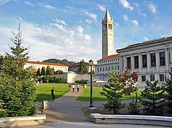
The Bay Area is home to a large number of colleges and universities. The first institution of higher education in the Bay Area, Santa Clara University, was founded by Jesuits in 1851, [209] who also founded the University of San Francisco in 1855. [210] San Jose State University was founded in 1857 and is the oldest public college on the West Coast of the United States. [211] According to the Brookings Institution, 45% of residents of the two-county San Jose metro area have a college degree and 43% of residents in the five-county San Francisco metro area have a college degree, the second and fourth-highest ranked metro areas in the country for higher educational attainment. [212]

Rankings compiled by U.S. News & World Report feature several Bay Area universities in prominent spots. Stanford University is one of the world’s preeminent research universities, ranked #1 in the world for its business school and law school. [213] The University of California, Berkeley has been the highest-ranked public university in the country for the past nineteen years. Additionally, San Jose State University and Sonoma State University were respectively ranked sixth and tenth among public colleges in the West Coast. [214]

Stanford University Main Quad (cropped).jpg
Berkeley glade afternoon.jpg
Stanford University (top) and University of California, Berkeley (top) are widely considered two of the most prestigious universities in the world.

The city of San Francisco is host to two additional University of California schools, neither of which confer undergraduate degrees. The University of California, San Francisco is entirely dedicated to graduate education in health and biomedical sciences. It is ranked among the top five medical schools in the United States [215] and operates the UCSF Medical Center, which is the highest-ranked hospital in California. [216] The University of California, College of the Law, founded in Civic Center in 1878, is the oldest law school in California and claims more judges on the state bench than any other institution. [217] The city is also host to a California State University school, San Francisco State University. [218] Additional campuses of the California State University system in the Bay Area are Cal State East Bay in Hayward and Cal Maritime in Vallejo.

California Community Colleges System also operates a number of community colleges in the Bay Area. According to CNNMoney, the Bay Area community college with the highest "success" rate is De Anza College in Cupertino, which is also the tenth-highest ranked in the nation. Other relatively well-ranked Bay Area community colleges include Foothill College, City College of San Francisco, West Valley College, Diablo Valley College, and Las Positas College. [219]

Many scholars have pointed out the overlap of education and the economy within the Bay Area. According to multiple reports, research universities such as Stanford University, University of California - Santa Cruz and University of California - Berkeley, are essential to the culture and economy in the area. [160] These universities also provide public programs for people to learn and enhance skills relevant to the local economies. These opportunities not only provide educational services to the community, but also generate significant amounts of revenue. [160]

Primary and secondary schools

The Galileo Academy of Science & Technology, an SFUSD public school Galileo Academy of Science and Technology entrance.jpg
The Galileo Academy of Science & Technology, an SFUSD public school

Public primary and secondary education in the Bay Area is provided through school districts organized through three structures (elementary school districts, high school districts, or unified school districts) and are governed by an elected board. In addition, many Bay Area counties and the city of San Francisco operate "special service schools" that are geared towards providing education to students with handicaps or special needs. [220]

An alternative public educational setting is offered by charter schools, which may be established with a renewable charter of up to five years by third parties. The mechanism for charter schools in the Bay Area is governed by the California Charter Schools Act of 1992. [221]

Bellarmine College Preparatory is one of the oldest schools in California. Bellarmine-Sobrato-Center-1-1 (cropped).jpg
Bellarmine College Preparatory is one of the oldest schools in California.

According to rankings compiled by U.S. News & World Report , the highest-ranked high school in California is the Pacific Collegiate School, located in Santa Cruz and part of the greater Bay Area. Within the traditional nine-county boundaries, the highest ranked high school is KIPP San Jose Collegiate in San Jose. Among the top twenty high schools in California include Lowell High School in San Francisco, Monta Vista High School in Cupertino, Lynbrook High School in San Jose, the University Preparatory Academy in San Jose, Mission San Jose High School in Fremont, Oakland Charter High School in Oakland, Henry M. Gunn High School in Palo Alto, Gilroy Early College Academy in Gilroy, and Saratoga High School in Saratoga. [222]

Transportation

The Bay Area is served by a variety of rail transit systems, including ACE, Amtrak, BART, Caltrain, Muni Metro, SMART, and VTA. Bayarea rail transit 2021.png
The Bay Area is served by a variety of rail transit systems, including ACE, Amtrak, BART, Caltrain, Muni Metro, SMART, and VTA.

Transportation in the San Francisco Bay Area is reliant on a complex multimodal infrastructure consisting of roads, bridges, highways, rail, tunnels, airports, ferries, and bike and pedestrian paths. The development, maintenance, and operation of these different modes of transportation are overseen by various agencies, including the California Department of Transportation (Caltrans), San Francisco Municipal Transportation Agency, and the Metropolitan Transportation Commission. [223] These and other organizations collectively manage several interstate highways and state routes, two subway networks, three commuter rail agencies, eight trans-bay bridges, transbay ferry service, local bus service, [224] three international airports (San Francisco, San Jose, and Oakland), [225] and an extensive network of roads, tunnels, and paths such as the San Francisco Bay Trail. [226]

The Bay Area hosts an extensive freeway and highway system that is particularly prone to traffic congestion, with one study by Inrix concluding that the Bay Area's traffic was the fourth worst in the world. [227] There are some city streets in San Francisco where gaps occur in the freeway system, partly the result of the Freeway Revolt, which prevented a freeway-only thoroughfare through San Francisco between the San Francisco–Oakland Bay Bridge, the western terminus of Interstate 80, and the southern terminus of the Golden Gate Bridge (U.S. Route 101). [228] Additional damage that occurred in the wake of the 1989 Loma Prieta earthquake resulted in freeway segments being removed instead of being reinforced or rebuilt, leading to the revitalization of neighborhoods such as San Francisco's Embarcadero and Hayes Valley. [229] The greater Bay Area contains the three principal north–south highways in California: Interstate 5, U.S. Route 101, and California State Route 1. U.S. 101 and State Route 1 directly serve the traditional nine-county region, while Interstate 5 bypasses to the east in San Joaquin County to provide a more direct Los AngelesSacramento route. Additional local highways connect the various subregions of the Bay Area together. [230]

Bay Area Rapid Transit (BART) serves 50 stations across the region, excluding the North Bay counties. BART D car on display at Dublin-Pleasanton, October 2016.jpg
Bay Area Rapid Transit (BART) serves 50 stations across the region, excluding the North Bay counties.

There are over two dozen public transit agencies in the Bay Area with overlapping service areas that utilize different modes, with designated connection points between the various operators. Bay Area Rapid Transit (BART), a heavy rail/metro system, operates in five counties and connects San Francisco and Oakland via the Transbay Tube. Other commuter rail systems link San Francisco with the Peninsula and San Jose (Caltrain), San Jose with the Tri-Valley Area and San Joaquin County (ACE), and Sonoma with Marin County (SMART). [224]

In addition, Amtrak provides frequent commuter service between San Jose and the East Bay with Sacramento, and long-distance service to other parts of the United States. [231] Muni Metro operates a hybrid streetcar/subway system within the city of San Francisco, and VTA operates a light rail system in Santa Clara County. These rail systems are supplemented by numerous bus agencies and transbay ferries such as Golden Gate Ferry and the San Francisco Bay Ferry. Most of these agencies accept the Clipper Card, a reloadable contactless smart card, as a universal electronic payment system. [224]

Government and politics

The Government of San Francisco is based at San Francisco City Hall. San Francisco City Hall 2.JPG
The Government of San Francisco is based at San Francisco City Hall.

Government in the San Francisco Bay Area consists of multiple actors, including 101 city and nine county governments, a dozen regional agencies, and a large number of single-purpose special districts such as municipal utility districts and transit districts. [232] Incorporated cities are responsible for providing police service, zoning, issuing building permits, and maintaining public streets among other duties. [233] County governments are responsible for elections and voter registration, vital records, property assessment and records, tax collection, public health, agricultural regulations, and building inspections, among other duties. [234] [235] Public education is provided by independent school districts, which may be organized as elementary districts, high school districts, unified school districts combining elementary and high school grades, or community college districts, and are managed by an elected school board. [220] A variety of special districts also exist and provide a single purpose, such as delivering public transit in the case of the Bay Area Rapid Transit District, [236] or monitoring air quality levels in the case of the Bay Area Air Quality Management District. [67]

The Government of San Jose is based at San Jose City Hall. Sanjosecityhall (cropped).jpg
The Government of San Jose is based at San Jose City Hall.

Politics in the Bay Area is widely regarded as one of the most liberal in California and in the United States. [237] [238] Since the late 1960s, the Bay Area has cemented its role as the most liberal region in California politics, giving greater support for the center-left Democratic Party's candidates than any other region of the state, even as California trended towards the Democratic Party over time. [239] According to research by the Public Policy Institute of California, the Bay Area and the North Coast counties of Humboldt and Mendocino were the most consistently and strongly liberal areas in California. [239]

According to the California Secretary of State, the Democratic Party holds a voter registration advantage in every congressional district, State Senate district, State Assembly district, State Board of Equalization district, all nine counties, and all of the 101 incorporated municipalities in the Bay Area. On the other hand, the center-right Republican Party holds a voter registration advantage in only one State Assembly sub-district (the portion of the 4th in Solano County). [240] According to the Cook Partisan Voting Index (CPVI), the Bay Area's districts tend to favor Democratic candidates by roughly 40 to 50 percentage points, considerably above the mean for California and the nation overall. [241]

Oakland City Hall Oakland City Hall (Oakland, CA) 2.JPG
Oakland City Hall

In U.S. Presidential elections since 1960, the nine-county Bay Area voted for Republican candidates only two times, in both cases voting for a Californian: in 1972 for Richard Nixon and again in 1980 for Ronald Reagan. The last county to vote for a Republican presidential candidate was Napa county in 1988 for George H. W. Bush. Since then, all nine Bay Area counties have voted consistently for the Democratic candidate. [244] Currently, both of California's U.S. Senators are Democrats, and all twelve U.S. congressional districts located wholly or partially in the Bay Area are represented by a Democratic representative. Additionally, every Bay Area member of the California State Senate and the California State Assembly is a registered Democrat.

The Bay Area's association with progressive politics has led to the term "San Francisco values" being used by conservative commentators in a pejorative sense to describe the secular progressive culture in the area. [245]

Regional governance

The Association of Bay Area Governments (ABAG) is the principal metropolitan planning organization for the Bay Area. The Metropolitan Transportation Commission (MTC) is the region's transportation planning agency, which has functionally merged with ABAG through staff consolidation. ABAG and MTC developed Plan Bay Area, which is the area's regional transportation plan, in 2013 and with its goal date for 2040.

Other regional governance agencies include the Bay Area Air Quality Management District, Bay Area Toll Authority, Bay Restoration Authority, and the Bay Conservation & Development Commission.

Culture

Arts

Cantor Arts Center in Stanford Iris & B. Gerald Cantor Center for Visual Arts, Stanford, California - 20060728 (cropped).jpg
Cantor Arts Center in Stanford

The Bay Area was a hub of the Abstract Expressionism movement of painting. It is associated with the works of Clyfford Still, who began teaching at the California School of Fine Arts (now the San Francisco Art Institute) in 1946, leaving a lasting influence on the artistic styles of Bay Area painters up to the present day. [246] A few years later, Abstract Expressionist painter David Park painted Kids on Bikes in 1950, which retained many aspects of abstract expressionism but with original distinguishing features that would later lead to the Bay Area Figurative Movement. [247]

The California Palace of the Legion of Honor of Fine Arts Museums SF California Palace of the Legion of Honor, 02 (cropped2).JPG
The California Palace of the Legion of Honor of Fine Arts Museums SF

While both the Figurative Movement and the Abstract Expressionism movement arose from art schools, Funk art would later rise out of the region's underground and was characterized by informal sharing of technique among groups of friends and art showcases in "cooperative" galleries instead of formal museums. Later, the Bay Area art movement would be heavily influenced by the counterculture movement in the 1960s, and art produced during this time reflected the political environment. [248]

Oakland Museum of California Oakland museum of california (9114782562).jpg
Oakland Museum of California

The San Francisco Renaissance was an era of poetic activity centered on San Francisco and poets such as Gary Snyder, Allen Ginsberg, Lawrence Ferlinghetti, which brought it to prominence as a hub of the American poetry avant-garde in the 1950s. The movement, which often included visual and performing arts, was heavily influenced by cross-cultural interests, particularly Buddhism, Taoism, and a general interest in East Asian cultures. [249]

The Bay Area is presently home to a thriving computer animation industry [250] led by Pixar Animation Studios and Industrial Light & Magic. Pixar, based in Emeryville, produced the first fully computer animated feature film, Toy Story , with software it designed in-house and whose computer animation films have since garnered 26 Academy Awards and critical acclaim. [251] Industrial Light & Magic, which is based in the Presidio in San Francisco, was created in 1975 to help create visual effects for the Star Wars series has since been involved with creating visual effects for over three hundred Hollywood films. [252]

Music

Baile folklorico at the 240th anniversary of the founding of San Jose at the Gonzales-Peralta Adobe Happy Birthday San Jose (24637280068).jpg
Baile folklórico at the 240th anniversary of the founding of San Jose at the Gonzales-Peralta Adobe

Throughout its recent history, the Bay Area has been home to several musical movements that left lasting influences on the genres they affected. San Francisco, in particular, was the center of the counterculture movement in the 1960s, which directly led to the rise of several notable musical acts: The Grateful Dead, which formed in 1965, and Jefferson Airplane and Janis Joplin; all three would be closely associated with the 1967 Summer of Love. [253] Jimi Hendrix also had strong connections to the movement and the Bay Area, as he lived in Berkeley for a brief time as a child and played in many local venues in that decade. [254] [253] By the 1970s, San Francisco had developed a vibrant jazz scene, earning the moniker, "Harlem of the West". [153] The Vietnam War was being fought at the time, and Bay Area bands such as Creedence Clearwater Revival of El Cerrito became known for their political and socially-conscious lyrics against the conflict. [255] Carlos Santana rose to fame in the early 1970s with his Santana band and would later be inducted into the Rock and Roll Hall of Fame. [256] Two former members of Santana, Neal Schon and Gregg Rolie would later lead the formation of the band Journey. [257]

The San Francisco Symphony at the Davies Symphony Hall Davies Symphony Hall, San Francisco, CA.jpg
The San Francisco Symphony at the Davies Symphony Hall

During the 1980s and early 1990s, the Bay Area became home to heavy metal and hard rock bands, including Ludicra, [258] and also to one of the largest and most influential thrash metal scenes in the world, with contributions from Exodus, Testament, Death Angel, Forbidden, Vio-lence, Lȧȧz Rockit, Possessed and Blind Illusion, in addition to three of the "Big Four" (Metallica, Slayer and Megadeth); although Metallica, Slayer and Megadeth were all technically from Los Angeles, those bands are often credited for popularizing and contributing to the Bay Area thrash metal scene during the 1980s by frequently playing shows there, especially early in their careers and/or before they were signed to a record label. [259] [260]

Mountain Winery is a concert venue and vineyard in Saratoga. Paul Masson Mountain Winery, Pierce Rd., Saratoga, CA 9-23-2012 12-12-19 PM (cropped).JPG
Mountain Winery is a concert venue and vineyard in Saratoga.

The post-grunge era in the 1990s featured prominent Bay Area bands Third Eye Blind of San Francisco, Counting Crows of Berkeley, and Smash Mouth of San Jose, and later pop punk rock bands like Green Day. [254]

The 1990s also saw the emergence of the influential hyphy movement in hip hop, derived from the Oakland slang for "hyperactive", and pioneered by Bay Area rappers Andre "Mac Dre" Hicks, Mistah Fab, and E-40. [261] Other notable rappers from the Bay Area include Lil B, [262] Tupac Shakur, MC Hammer, Too $hort, and G-Eazy. [263] Today, much of the rap coming out of Oakland and the East Bay is "conscious rap", which concerns itself with social issues and awareness. [263]

The Bay Area is also home to hundreds of classical music ensembles, from community choirs to professional orchestras, such as the San Francisco Symphony, California Symphony, Fremont Symphony Orchestra, Oakland Symphony and the San Francisco Chamber Orchestra. [264]

Theater

Fox Theatre in Redwood City USA-Redwood City-New Sequoia Theater Building-2.jpg
Fox Theatre in Redwood City

According to the regional theater service organization Theatre Bay Area, the San Francisco Bay Area is the third largest center of activity for theater companies and actors in the United States, after the New York City and Chicago metropolitan areas, with 400 companies spread throughout the region. [265] The organization was founded in 1976 by the Magic Theatre and American Conservatory Theater (ACT) in San Francisco and the Berkeley Repertory Theatre in Berkeley. [266] The latter two, along with the San Francisco Mime Troupe and Palo Alto-based Theatreworks, have since gone on to win one Regional Theatre Tony Award each. [267] [268]

War Memorial Opera House is the home of the San Francisco Opera and the San Francisco Ballet. SFOperaHouse.jpg
War Memorial Opera House is the home of the San Francisco Opera and the San Francisco Ballet.

Several famous actors have arisen from the Bay Area's theatre community, including Daveed Diggs from Hamilton and Darren Criss from Hedwig , A Very Potter Musical , and Glee . [269] Locally, well-regarded actors include James Carpenter, a stage actor who has performed at the ACT, Berkeley Repertory, and San Jose Repertory Theatre among others, Rod Gnapp of the Magic Theatre Company, Sean San Jose, one of the founders of the Campo Santo theater, and Campo Santo member Margo Hall. [270]

The Bay Area also has an active youth theater scene. ACT and the Berkeley Repertory both run classes and camps for young actors, as do the Peninsula Youth Theater and Willow Glen Children's Theatre in the Peninsula and South Bay, Bay Area Children's Theater and Danville Children's Musical Theater in the East Bay, and Marin Shakespeare in the North Bay, among many others. [271] [272]

Media

Sutro Tower is a broadcast tower and local landmark. Sutro Tower from Grandview.jpg
Sutro Tower is a broadcast tower and local landmark.

The San Francisco Bay Area is the tenth-largest television market [273] and the fourth-largest radio market [274] in the U.S. The Bay Area's oldest radio station, KCBS (AM), began as an experimental station in San Jose in 1909, before the beginning of commercial broadcasting. [275] KALW was the Bay Area's first FM radio station, and first radio station to begin commercial broadcasting west of the Mississippi River when it signed on the air in 1941. [276] KPIX, which began broadcasting in 1948, was the first television station to air in the Bay Area and Northern California. [277]

All major U.S. television networks have affiliates serving the region, including KTVU 2 (FOX), KRON-TV 4 (The CW/MyNetwork), KPIX 5 (CBS), KGO-TV 7 (ABC), KQED-TV 9 (PBS), KNTV 11 (NBC), KICU-TV 36 (Independent), KPYX 44 (Independent), KQEH 54 (PBS), and KKPX 65 (Ion). Bloomberg West, a show that focuses on topics pertaining to technology and business, was launched in 2011 from a studio in and continues to broadcast from San Francisco. [278]

Public broadcasting outlets include both a television station and a radio station, both broadcasting under the call letters KQED from a facility near the Potrero Hill neighborhood. KQED-FM is the most-listened-to National Public Radio affiliate in the country. [279] Another local broadcaster, KPOO, is an independent, African-American owned and operated noncommercial radio station established in 1971. [280]

Pixar headquarters in Emeryville Pixar - front gates.jpg
Pixar headquarters in Emeryville

The largest newspapers in the Bay Area are the San Francisco Chronicle and San Jose Mercury News , the highest and second-highest most widely circulated newspaper in Northern California. [281] The Chronicle is most famous for a former columnist, the late Herb Caen, whose daily musings attracted critical acclaim and represented the "voice of San Francisco". The San Francisco Examiner , once the cornerstone of William Randolph Hearst's media empire and the home of Ambrose Bierce, declined in circulation over the years and now takes the form of a free daily tabloid, under new ownership. [282] [283] Most of the Bay Area's local regions and municipalities also have their own newspapers, such as the East Bay Times and San Mateo Daily Journal . The national newsmagazine Mother Jones is also based in San Francisco. [284] Non-English-language newspapers include several Chinese-language papers such as Sing Tao Daily , the largest in the Bay Area by circulation, [285] and El Mundo, a free Spanish-language weekly distributed by the Mercury News. [286]

Sports and recreation

Oracle Park, home of the SF Giants of Major League Baseball AT&T Park July 24, 2016.jpg
Oracle Park, home of the SF Giants of Major League Baseball

The Bay Area is home to six professional major league sports franchises: The San Francisco 49ers of the National Football League (NFL) in American football, the San Francisco Giants and Oakland Athletics of Major League Baseball (MLB), the Golden State Warriors of the National Basketball Association (NBA), the San Jose Sharks of the National Hockey League (NHL), and the San Jose Earthquakes of Major League Soccer (MLS).

In football, the 49ers play in Levi's Stadium [287] and have won five Super Bowls (XVI, [288] XIX, [289] XXIII, [290] XXIV, [291] XXIX [292] ) and lost two (XLVII [293] and LIV [294] ).

In baseball, the Giants, who play at Oracle Park, [295] have won eight World Series titles, three since relocating to San Francisco (2010, 2012, and 2014) from New York in 1958. [296] The Athletics, who play at the Oakland Coliseum, [297] have won nine World Series titles, four since relocating to Oakland (1972, 1973, 1974, and 1989) from Kansas City in 1968. [296]

PayPal Park, home of the San Jose Earthquakes of Major League Soccer Avaya Stadium 2016 screenshot 03.jpg
PayPal Park, home of the San Jose Earthquakes of Major League Soccer

In basketball, the Warriors play at the Chase Center and have won seven NBA Finals, five since relocating to the Bay Area (1975, 2015, 2017, 2018 and 2022) from Philadelphia in 1962. [298]

In hockey, the Sharks play at the SAP Center. They made their first Stanley Cup Finals appearance in 2016 but have not won the Stanley Cup.

In soccer, the Earthquakes play at PayPal Park [299] and have won the MLS Cup twice in 2001 and 2003. The Bay Area hosted matches during the 1994 FIFA World Cup at Stanford Stadium and will host matches during the 2026 FIFA World Cup at Levi's Stadium. [300] The Bay Area hosted some of the soccer competition during the 1984 Summer Olympics and will do so again during the 2028 Summer Olympics. [301] [302]

Levi's Stadium in Santa Clara, home of the San Francisco 49ers of the National Football League Broncos vs 49ers preseason game at Levi's Stadium.jpg
Levi's Stadium in Santa Clara, home of the San Francisco 49ers of the National Football League

Outside of major league sports, the Bay Area is home to three minor league franchises. In hockey, the San Jose Barracuda play in the American Hockey League (AHL) and are the top affiliate of the San Jose Sharks, sharing the same rink at the SAP Center in San Jose. [303] In baseball, the San Jose Giants in the California League of Minor League Baseball (MiLB) are the Low-A affiliate of the San Francisco Giants, playing out of the San Jose Municipal Stadium. [304] In soccer, the Oakland Roots in the USL Championship, the second division of American soccer, currently play at Laney Field at Laney College. [305]

In terms of collegiate sports, six Bay Area universities are members of NCAA Division I, the highest level of college sports in the country. [306] All three football-playing schools in the Bay Area are in the Football Bowl Subdivision, the highest level of NCAA college football. The California Golden Bears and Stanford Cardinal compete in the Pac-12 Conference, and the San Jose State Spartans compete in the Mountain West Conference. [307] The Cardinal and Golden Bears are intense rivals, with their football teams competing annually in the Big Game for the Stanford Axe. [308] One of the most famous games in the rivalry occurred in 1982, when the Golden Bears defeated the Cardinal on a last-second return kickoff known as "The Play". [309]

The Tour of California in Morgan Hill Tour of California Morgan Hill (cropped).jpg
The Tour of California in Morgan Hill

The Bay Area has an ideal climate for outdoor recreation, such that activities like hiking, cycling and jogging are popular among locals. [310] [311] There are more than 200 mi (320 km) of bicycle paths, lanes and bike routes just within San Francisco, [312] and the Embarcadero and Marina Green are favored sites for skateboarding. Extensive public tennis facilities are available in Golden Gate Park and Dolores Park, as well as at smaller neighborhood courts throughout the city. Boating, sailing, windsurfing and kitesurfing are among the popular activities on San Francisco Bay, and the city maintains a yacht harbor in the Marina District. The St. Francis Yacht Club and Golden Gate Yacht Club are located in the Marina Harbor, [313] [314] while the South Beach Yacht Club is located next to Oracle Park. [315] The Bay Area was host to the 2013 America's Cup. Other Bay Area yacht clubs include the Alameda Yacht Club, [316] Berkeley Yacht Club, [317] Corinthian Yacht Club [318] in Tiburon, Oakland Yacht Club, [319] Presidio Yacht Club, [320] Sausalito Yacht Club and Sequoia Yacht Club [321] in Redwood City.

See also

Related Research Articles

<span class="mw-page-title-main">Oakland, California</span> City in Alameda County, California, United States

Oakland is the most populous city and the county seat of Alameda County, California, United States. A major West Coast port, Oakland is the largest city in the East Bay region of the San Francisco Bay Area, and the third-largest city overall in the Bay Area. With a population of 440,646 in 2020, it serves as the Bay Area's trade center: the Port of Oakland is the busiest port in Northern California, and the fifth- or sixth-busiest in the United States. A charter city, Oakland was incorporated on May 4, 1852, in the wake of the state's increasing population due to the California gold rush.

<span class="mw-page-title-main">San Jose, California</span> City in California, United States

San Jose, officially the City of San José, is the largest city in Northern California by both population and area. With a 2022 population of 971,233, it is the most populous city in both the Bay Area and the San Jose–San Francisco–Oakland Combined Statistical Area—which in 2022 had a population of 7.5 million and 9.0 million respectively—the third-most populous city in California after Los Angeles and San Diego, and the 12th-most populous in the United States. Located in the center of the Santa Clara Valley on the southern shore of San Francisco Bay, San Jose covers an area of 179.97 sq mi (466.1 km2). San Jose is the county seat of Santa Clara County and the main component of the San Jose–Sunnyvale–Santa Clara Metropolitan Statistical Area, with an estimated population of around two million residents in 2018.

<span class="mw-page-title-main">Southern California</span> American geographic and cultural region

Southern California is a geographic and cultural region that generally comprises the southern portion of the U.S. state of California. It includes the Los Angeles metropolitan area as well as the Inland Empire. The region generally contains ten of California's 58 counties: Imperial, Kern, Los Angeles, Orange, Riverside, San Bernardino, San Diego, Santa Barbara, San Luis Obispo and Ventura counties.

<span class="mw-page-title-main">Alameda County, California</span> County in California, United States

Alameda County is a county located in the U.S. state of California. As of the 2020 census, the population was 1,682,353, making it the 7th-most populous county in the state and 21st most populous nationally. The county seat is Oakland. Alameda County is in the San Francisco Bay Area, occupying much of the East Bay region.

<span class="mw-page-title-main">Contra Costa County, California</span> County in California, United States

Contra Costa County is a county located in the U.S. state of California, in the East Bay of the San Francisco Bay Area. As of the 2020 United States Census, the population was 1,165,927. The county seat is Martinez. It occupies the northern portion of the East Bay region of the San Francisco Bay Area and is primarily suburban. The county's name refers to its position on the other side of the bay from San Francisco. Contra Costa County is included in the San Francisco–Oakland–Berkeley, CA Metropolitan Statistical Area.

<span class="mw-page-title-main">Morgan Hill, California</span> City in California, United States

Morgan Hill is a city in Santa Clara County, California, at the southern tip of Silicon Valley in the San Francisco Bay Area. Morgan Hill is an affluent residential community, the seat of several high-tech companies, and a dining, entertainment, and recreational destination, owing to its luxury hospitality, wineries, and nature parks.

<span class="mw-page-title-main">Sunnyvale, California</span> City in California, United States

Sunnyvale is a city located in the Santa Clara Valley in northwest Santa Clara County in the U.S. state of California.

<span class="mw-page-title-main">Northern California</span> American geographic and cultural region

Northern California is a geographic and cultural region that generally comprises the northern portion of the U.S. state of California, spanning the northern 48 of the state's 58 counties. Its main population centers include the San Francisco Bay Area, the Greater Sacramento area, the Redding, California, area south of the Cascade Range, and the Metropolitan Fresno area. Northern California also contains redwood forests, along with most of the Sierra Nevada, including Yosemite Valley and part of Lake Tahoe, Mount Shasta, and most of the Central Valley, one of the world's most productive agricultural regions.

<span class="mw-page-title-main">Santa Clara Valley</span> Valley in Northern California, United States

The Santa Clara Valley is a geologic trough in Northern California that extends 90 miles (140 km) south–southeast from San Francisco to Hollister. The longitudinal valley is bordered on the west by the Santa Cruz Mountains and on the east by the Diablo Range; the two coastal ranges meet south of Hollister. The San Francisco Bay borders the valley to the north, and fills much of the northern third of the valley. The valley floor is an alluvial plain that formed in the graben between the San Andreas Fault to the west and the Hayward and Calaveras faults to the east. Within the valley and surrounding the bay on three sides are the urban communities of San Mateo County, Santa Clara County, and Alameda County, while the narrow southern reaches of the valley extend into rural San Benito County to Hollister. In practical terms, the central portion of the Santa Clara Valley is often considered by itself, contained entirely within Santa Clara County.

<span class="mw-page-title-main">Central Coast (California)</span> Region of California in the United States

The Central Coast is an area of California, roughly spanning the coastal region between Point Mugu and Monterey Bay. It lies northwest of Los Angeles and south of the San Francisco Bay Area, and includes the rugged, rural, and sparsely populated stretch of coastline known as Big Sur.

<span class="mw-page-title-main">Alviso, San Jose</span> Neighborhood of San Jose in San Francisco Bay Area, California, United States

Alviso is a district of San Jose, California, located in North San Jose on the southern shores of San Francisco Bay. Originally an independent town, founded in 1852, today Alviso is San Jose's only waterfront district, primarily residential in nature, with several Silicon Valley tech companies and recreation-oriented businesses. Alviso is named after 19th-century Californio ranchero Ignacio Alviso, who owned the area as part of his Rancho Rincón de Los Esteros.

<span class="mw-page-title-main">East Bay</span> Eastern region of the San Francisco Bay Area, California, US

The East Bay is the eastern region of the San Francisco Bay Area and includes cities along the eastern shores of the San Francisco Bay and San Pablo Bay. The region has grown to include inland communities in Alameda and Contra Costa counties. With a population of roughly 2.5 million in 2010, it is the most populous subregion in the Bay Area.

<span class="mw-page-title-main">Transportation in the San Francisco Bay Area</span> Overview of transportation in the San Francisco Bay Area, California, United States

People in the San Francisco Bay Area rely on a complex multimodal transportation infrastructure consisting of roads, bridges, highways, rail, tunnels, airports, seaports, and bike and pedestrian paths. The development, maintenance, and operation of these different modes of transportation are overseen by various agencies, including the California Department of Transportation (Caltrans), the Association of Bay Area Governments, San Francisco Municipal Transportation Agency, and the Metropolitan Transportation Commission. These and other organizations collectively manage several interstate highways and state routes, eight passenger rail networks, eight trans-bay bridges, transbay ferry service, local and transbay bus service, three international airports, and an extensive network of roads, tunnels, and bike paths.

<span class="mw-page-title-main">Demographics of California</span>

California is the most populated U.S. state, with an estimated population of 38.9 million as of 2023. It has people from a wide variety of ethnic, racial, national, and religious backgrounds.

San Jose, California, is the third largest city in the state, and the largest of all cities in the San Francisco Bay Area and Northern California, with a population of 1,021,795.

<span class="mw-page-title-main">1868 Hayward earthquake</span> 1868 earthquake in the San Francisco Bay Area, California, United States

The 1868 Hayward earthquake occurred in the San Francisco Bay Area, California, United States on October 21. With an estimated moment magnitude of 6.3–6.7 and a maximum Mercalli intensity of IX (Violent), it was the most recent large earthquake to occur on the Hayward Fault Zone. It caused significant damage and a number of deaths throughout the region, and was known as the "Great San Francisco earthquake" prior to the 1906 San Francisco earthquake and fire.

<span class="mw-page-title-main">Outline of California</span> Overview of and topical guide to California

The following outline is provided as an overview of and topical guide to the U.S. state of California.

<span class="mw-page-title-main">Santa Clara County, California</span> County in California, United States

Santa Clara County, officially the County of Santa Clara, is the sixth-most populous county in the U.S. state of California, with a population of 1,936,259, as of the 2020 census. Santa Clara County and neighboring San Benito County together form the U.S. Census Bureau's San Jose–Sunnyvale–Santa Clara metropolitan statistical area, which is part of the larger San Jose–San Francisco–Oakland combined statistical area. Santa Clara is the most populous county in the San Francisco Bay Area and in Northern California. The county seat and largest city is San Jose; with about 1,000,000 residents, it is the 10th-most populous city in the United States, California's third-most populous city and the most populous city in the San Francisco Bay Area. The second- and third-largest cities are Sunnyvale and Santa Clara.

<span class="mw-page-title-main">COVID-19 pandemic in the San Francisco Bay Area</span> Ongoing COVID-19 viral pandemic in the San Francisco Bay Area

The San Francisco Bay Area, which includes the major cities of San Jose, San Francisco, and Oakland, was an early center of the COVID-19 pandemic in California. The first case of COVID-19 in the area was confirmed in Santa Clara County on January 31, 2020. A Santa Clara County resident was the earliest known death caused by COVID-19 in the United States, on February 6, suggesting that community spread of COVID-19 had been occurring long before any actual documented case. This article covers the 13 members of ABAHO, which includes the nine-county Bay Area plus the counties of Monterey, San Benito, and Santa Cruz.

References

  1. "Square Mileage by County". California States Association of Counties. Archived from the original on February 27, 2019. Retrieved September 21, 2017.
  2. Hinrichs, Scott (September 28, 2006). "Mt. Hamilton Lick Observatory". Archived from the original on August 20, 2010. Retrieved September 21, 2017.
  3. Kurhi, Eric (December 11, 2014). "San Jose: Overwhelmed pumps led to Alviso flooding; residents say it's a 'wake-up call'". San Jose Mercury News . Archived from the original on March 3, 2016. Retrieved September 21, 2017.
  4. 1 2 "2020 Population and Housing State Data". United States Census Bureau . Retrieved August 19, 2021.
  5. "GDP by county in 2022" (PDF). www.unc.edu.
  6. "Gross Domestic Product by County and Metropolitan Area", Federal Reserve Economic Data , Federal Reserve Bank of St. Louis
  7. "Area Code Map for Northern California/Bay Area". White Pages. Archived from the original on September 24, 2017. Retrieved September 21, 2017.
  8. Scott, Mel (1985). The San Francisco Bay Area: A Metropolis in Perspective (2 ed.). University of California Press. p. ix. ISBN   9780520055124.
  9. 1 2 3 4 Office of Management and Budget (July 21, 2023). "OMB Bulletin 23-01" (PDF). Retrieved October 11, 2023.
  10. 1 2 "The Association of Ramaytush Ohlone". The Association of Ramaytush Ohlone. Retrieved December 14, 2023.
  11. 1 2 ThemeZaa. "Muwekma Ohlone Tribe | American Indian | Native American Tribes". Muwekma Ohlone Tribe. Retrieved December 14, 2023.
  12. "IPUMS NHGIS | National Historical Geographic Information System". www.nhgis.org. Retrieved December 8, 2023.
  13. "Home". Bay Area Council. Archived from the original on August 31, 2019. Retrieved September 7, 2019.
  14. "2019 Sacramento Economic Forecast" (PDF). Bay Area Council. Archived (PDF) from the original on October 26, 2019.
  15. "It's Official: A Quarter Million People Fled the Bay Area Since 2020". The San Francisco Standard. March 31, 2023. Retrieved December 18, 2023.
  16. Bureau, US Census. "Metropolitan and Micropolitan Statistical Areas Population Totals: 2020-2022". Census.gov. Retrieved December 18, 2023.
  17. "U.S. Census website". U.S. Census Bureau. Archived from the original on August 7, 2022. Retrieved December 3, 2019.
  18. "San Jose no longer in Top 10 of most populous U.S. cities". The Mercury News. May 18, 2023. Retrieved May 20, 2023.
  19. Stewart, Suzanne B. (November 2003). "Archaeological Research Issues For The Point Reyes National Seashore – Golden Gate National Recreation Area" (PDF). Sonoma State University – Anthropological Studies Center. p. 11. Archived (PDF) from the original on June 24, 2008. Retrieved September 22, 2017.
  20. Billiter, Bill (January 1, 1985). "3,000-Year-Old Connection Claimed : Siberia Tie to California Tribes Cited". Los Angeles Times . Los Angeles. Archived from the original on November 28, 2014. Retrieved September 22, 2017.
  21. "Visitors: San Francisco Historical Information". City and County of San Francisco. Archived from the original on March 1, 2006. Retrieved June 10, 2008.
  22. Sugden, John (2006). Sir Francis Drake. London: Pimlico. pp. 130, 136, 137. ISBN   978-1-844-13762-6.
  23. Turner, Michael (2006). In Drake's Wake Volume 2 The World Voyage. United Kingdom: Paul Mould Publishing. p. 173. ISBN   978-1-904959-28-1.
  24. Davis, Loren; et al. (November 2013), "Inventory and Analysis of Coastal and Submerged Archaeological Site Occurrence on the Pacific Outer Continental Shelf", U.S. Department of the Interior, Bureau of Ocean Energy Management.
  25. Wagner, Henry R. (April 1924). "The Voyage to California of Sebastian Rodriguez Cermeño in 1595". California Historical Society Quarterly. 3 (1).
  26. Spate, O. H. K. (1979). The Pacific Since Magellan: The Spanish Lake. London: Croom Helm. p. 110. ISBN   9780816608829.
  27. Kuwayama, George (1997). Chinese Ceramics in Colonial Mexico. Honolulu: University of Hawaii Press. p. 20. ISBN   0-87587-179-8.
  28. Aker (1965)
  29. Rawls, James; Bean, Walton (2003). California: An Interpretive History. New York: McGraw-Hill. pp. 36–7. ISBN   9780070042414.
  30. Muñoz, Fray Pedro, et al. "The Gabriel Moraga Expedition of 1806: The Diary of Fray Pedro Muñoz." Huntington Library Quarterly, vol. 9, no. 3, 1946, pp. 223–248. JSTOR, www.jstor.org/stable/3816007. Accessed November 12, 2020.
  31. 1 2 "Introduction". Early History of the California Coast. National Park Service. Archived from the original on July 3, 2017. Retrieved September 22, 2017.
  32. Lee Foster (October 1, 2001). Northern California History Weekends. Globe Pequot. p. 13. ISBN   978-0-7627-1076-8. Archived from the original on May 27, 2016. Retrieved December 26, 2011.
  33. 1 2 3 The Virtual Museum of the City of San Francisco (July 16, 2004). "From the 1820s to the Gold Rush". The Virtual Museum of the City of San Francisco. Archived from the original on October 22, 2009. Retrieved September 22, 2017.
  34. Barkan, Elliott (2013). Immigrants in American History: Arrival, Adaptation, and Integration. Santa Barbara: ABC-CLIO. ISBN   978-1-59884-219-7.
  35. Harris, Ron (November 14, 2005). "Crews Unearth Shipwreck on San Francisco Condo Project". Associated Press. Archived from the original on December 23, 2010. Retrieved September 22, 2017.
  36. Castillo, Edward D. "Short Overview of California Indian History". California Native American Heritage Commission. Archived from the original on March 4, 2010. Retrieved October 9, 2017.
  37. Wilson, Dotson; Ebbert, Brian S. (2006). California's Legislature (PDF) (2006 ed.). Sacramento: California State Assembly. pp. 149–154. OCLC   70700867. Archived (PDF) from the original on July 6, 2017. Retrieved September 24, 2017.
  38. "Historical Census Statistics On Population Totals By Race, 1790 to 1990, and By Hispanic Origin, 1970 to 1990, For Large Cities And Other Urban Places In The United States". U.S. Census Bureau. Archived from the original on August 12, 2012. Retrieved December 18, 2011.
  39. "The Transcontinental Railroad: Transforing California and the Nation". UC Davis. Archived from the original on July 2, 2018. Retrieved September 22, 2017.
  40. "The Great 1906 San Francisco Earthquake". United States Geological Survey. Archived from the original on September 20, 2017. Retrieved September 24, 2017.
  41. "Casualties and damage after the 1906 Earthquake". United States Geological Survey. Archived from the original on October 18, 2017. Retrieved September 24, 2017.
  42. 1 2 Rodgers, Paul (April 15, 2006). "Ripples from 1906 San Francisco quake felt even today". The Seattle Times . Archived from the original on August 19, 2018. Retrieved September 24, 2017.
  43. "San Francisco Gold Rush Banking – 1849". The Virtual Museum of the City of San Francisco. June 24, 2004. Archived from the original on May 9, 2008. Retrieved September 24, 2017.
  44. Standen, Amy (May 27, 2012). "75 Years Ago, A Deadly Day On The Golden Gate". National Public Radio. Archived from the original on September 24, 2017. Retrieved September 24, 2017.
  45. Vorderbrueggen, Lisa (August 9, 2013). "Building the Bay Bridge: 1930s vs. today". San Jose Mercury News . Archived from the original on July 24, 2017. Retrieved September 24, 2017.
  46. 1 2 3 Nolte, Carl (May 28, 2012). "World War II reshaped the Bay Area and its people". San Francisco Chronicle . Archived from the original on September 25, 2017. Retrieved September 24, 2017.
  47. Wardlow, Chester (1999). The Technical Services—The Transportation Corps: Responsibilities, Organization, And Operations. United States Army In World War II. Washington, DC: Center Of Military History, United States Army. pp. 96–97, 100. LCCN   99490905 . Retrieved August 24, 2021.
  48. Bykofsky, Joseph; Larson, Harold (1990). The Technical Services—The Transportation Corps: Operations Overseas (PDF). United States Army In World War II. Washington, DC: Center Of Military History, United States Army. p. 39. LCCN   56060000 . Retrieved August 24, 2021.
  49. Thompson, Erwin N. (July 8, 1984). National Register of Historic Places Inventory—Nomination Form, San Francisco Port of Embarkation, U.S. Army (PDF) (Report). Denver, Colorado: National Park Service, Denver Service Center. p. Part 8, Significance, p.4. Retrieved September 9, 2021.
  50. "Treaty of Peace with Japan (with two declarations). Signed at San Francisco, on 8 September 1951" (PDF). United Nations. September 8, 1951. Archived (PDF) from the original on September 29, 2017. Retrieved September 24, 2017.
  51. 1 2 Ashbolt, Anthony (2013). A Cultural History of the Radical Sixties in the San Francisco Bay Area. Routledge. p. 4.
  52. "Scott McKenzie, 1960s counter-culture singer, dies at 73". The Daily Telegraph . August 20, 2012. Archived from the original on September 24, 2017. Retrieved September 24, 2017.
  53. Robertson, Mark (May 23, 2013). "Looking Back: Canning in the Valley of Heart's Delight". San Jose Public Library. Archived from the original on September 24, 2017. Retrieved September 24, 2017.
  54. "Shockley Semiconductor". Public Broadcasting Station. Archived from the original on October 26, 2017. Retrieved September 24, 2017.
  55. The New York Times (October 20, 1989). "The California Quake: The Bay Bridge; Damage to Link Across Bay Is More Serious Than Thought". The New York Times . Archived from the original on December 20, 2017. Retrieved October 9, 2017.
  56. "1990 and 1980 Census Counts for Cities with 1990 Population Greater Than 100,000". United States Census Bureau. Archived from the original on June 29, 2014. Retrieved August 8, 2014. 1980: San Francisco = 678974, San Jose = 629400. 1990: San Jose = 782248, San Francisco = 723959
  57. Clark, Tara (May 13, 2015). "When Did The Stock Market Crash? A List Of U.S. Markets' Worst Declines". ETF Daily News. Archived from the original on January 18, 2018. Retrieved September 24, 2017.
  58. 1 2 3 4 5 "Bay Area Census – Bay Area Data". Bayareacensus.ca.gov. Archived from the original on October 26, 2011. Retrieved November 4, 2011.
  59. "Gays rush to San Francisco to wed". BBC News. February 15, 2004. Archived from the original on October 6, 2014. Retrieved October 1, 2014.
  60. Wildermuth, John (November 5, 2008). "Voters backing same-sex marriage ban". San Francisco Chronicle . Archived from the original on October 9, 2017. Retrieved October 9, 2017.
  61. Jones, Carolyn (January 9, 2009). "Oakland storekeepers tell of night of terror". San Francisco Chronicle . Archived from the original on January 16, 2009. Retrieved January 10, 2009.
  62. Zennie62 (October 30, 2011). "Occupy Oakland: The Oscar Grant / Frank Ogawa Plaza Issue". San Francisco Chronicle . Archived from the original on November 5, 2011. Retrieved October 9, 2017.
  63. Kamisher, Eliyahu (August 29, 2023). "Move Over, San Francisco: The Suburbs of Silicon Valley Are Calling" . Bloomberg. Retrieved March 3, 2024.
  64. 1 2 3 Walker, Richard and Alex Schafran (2015). "The strange case of the Bay Area" (PDF). Environment and Planning. 47 (1): 11–13. Bibcode:2015EnPlA..47...10W. doi:10.1068/a46277. S2CID   143111595 . Archived from the original (PDF) on September 24, 2017. Retrieved September 24, 2017.
  65. Placzek, Jessica (September 6, 2018). "How Do You Define the 'Bay Area'?". KQED. Archived from the original on September 11, 2018. Retrieved September 10, 2018.
  66. "The Nine Regional Water Quality Control Boards in California" (PDF). California Water Boards. Archived (PDF) from the original on February 7, 2017. Retrieved September 18, 2017.
  67. 1 2 "About the Air District". Bay Area Air Quality Management District. Archived from the original on September 18, 2017. Retrieved September 18, 2017.
  68. "Welcome page". San Francisco Bay Restoration Authority. Archived from the original on September 12, 2017. Retrieved September 18, 2017.
  69. "Nine Bay Area counties". Metropolitan Transportation Commission. Archived from the original on September 25, 2017. Retrieved September 18, 2017.
  70. "ABAG Members". Association of Bay Area Governments. Archived from the original on September 29, 2017. Retrieved September 18, 2017.
  71. "Bay Area Census – Counties". Bay Area Census. Archived from the original on September 13, 2017. Retrieved September 18, 2017.
  72. "San Francisco-San Jose-Oakland Designated Media Market Data". Truck Ads. Archived from the original on September 20, 2017. Retrieved September 18, 2017.
  73. "2020 Population and Housing State Data". U.S. Census Bureau. August 12, 2021.
  74. Crawford, Sabrina (January 31, 2006). Newcomer's Handbook for Moving to And Living in the San Francisco Bay Area: Including San Jose, Oakland, Berkeley, And Palo Alto . First Books. pp.  99–129. ISBN   978-0-912301-63-1 . Retrieved February 9, 2013.
  75. Crawford, Sabrina (January 31, 2006). Newcomer's Handbook for Moving to And Living in the San Francisco Bay Area: Including San Jose, Oakland, Berkeley, And Palo Alto . First Books. pp.  78–98. ISBN   978-0-912301-63-1 . Retrieved February 9, 2013.
  76. Crawford, Sabrina (January 31, 2006). Newcomer's Handbook for Moving to And Living in the San Francisco Bay Area: Including San Jose, Oakland, Berkeley, And Palo Alto . First Books. pp.  130–156. ISBN   978-0-912301-63-1 . Retrieved February 9, 2013.
  77. Crawford, Sabrina (January 31, 2006). Newcomer's Handbook for Moving to And Living in the San Francisco Bay Area: Including San Jose, Oakland, Berkeley, And Palo Alto . First Books. pp.  9–182. ISBN   978-0-912301-63-1 . Retrieved February 9, 2013.
  78. Nolte, Carl (November 7, 2015). "Peninsula a surprise find south of S.F." San Francisco Chronicle . Archived from the original on September 24, 2017. Retrieved September 18, 2017.
  79. United States Department of Commerce, Office of Area Development (December 1959). Future Development of the San Francisco Bay Area, 1960–2020. p. 69.
  80. Groundwater Contamination Cleanups at South Bay Superfund Sites: Progress Report. United States Environmental Protection Agency, Region IX. April 1989. p. 3.
  81. Spangle, Frances; Rusmore, Jean (1984). South Bay Trails: Outdoor Adventures Around the Santa Clara Valley. Wilderness Press. p. 3. ISBN   9780899970226.
  82. 1 2 "Climate of San Francisco". Golden Gate Weather Services. 2009. Archived from the original on January 16, 2015. Retrieved September 19, 2017.
  83. 1 2 3 Miller, Miguel (April 1999). "Climate of San Jose". National Weather Service. Archived from the original on December 15, 2004. Retrieved September 19, 2017.
  84. 1 2 Gilliam, Harold (July–September 2002). "Cutting Through the Fog: Demystifying the Summer Spectacle". Bay Nature. Archived from the original on June 22, 2012. Retrieved September 24, 2017.
  85. 1 2 3 4 5 Gillam, Harold (July 9, 2001). "Weather as varied as the people / Land and fog build summer microclimates". San Francisco Chronicle . Archived from the original on January 8, 2013. Retrieved September 19, 2001.
  86. "Fairfield, California". National Climatic Data Center (NCDC) 1981-2010 Monthly Normals. Western Regional Climate Center (WRCC), National Oceanic and Atmospheric Administration (NOAA).
  87. "Oakland, California". National Climatic Data Center (NCDC) 1981-2010 Monthly Normals. Western Regional Climate Center (WRCC), National Oceanic and Atmospheric Administration (NOAA).
  88. "San Francisco Downtown, California". National Climatic Data Center (NCDC) 1981-2010 Monthly Normals. Western Regional Climate Center (WRCC), National Oceanic and Atmospheric Administration (NOAA).
  89. "San Jose". National Climatic Data Center (NCDC) 1981-2010 Monthly Normals. Western Regional Climate Center (WRCC), National Oceanic and Atmospheric Administration (NOAA).
  90. "Santa Rosa, California". National Climatic Data Center (NCDC) 1981-2010 Monthly Normals. Western Regional Climate Center (WRCC), National Oceanic and Atmospheric Administration (NOAA).
  91. "San Francisco Bay Area and Delta Protection". Center for Biological Diversity. Archived from the original on September 15, 2017. Retrieved September 19, 2017.
  92. "Current California Ocean Recreational Fishing Regulations". California Department of Fish and Wildlife. Archived from the original on September 24, 2017. Retrieved September 19, 2017.
  93. "From Salt Production to Salt Marsh". NASA Earth Observatory. February 11, 2016. Archived from the original on May 19, 2016. Retrieved September 19, 2017.
  94. Reiter, Matthew E.; et al. (April 2011). "A Monitoring Plan for Wintering Shorebids in the San Francisco Bay" (PDF). California Landscape Conservation Cooperative. Archived (PDF) from the original on August 19, 2018. Retrieved September 19, 2017.
  95. "Threatened and Endangered species". South Bay Restoration Project. Archived from the original on August 19, 2018. Retrieved September 19, 2017.
  96. Central California Coast Steelhead DPS (Report). NOAA's National Marine Fisheries Service Northwest Regional Office. Archived from the original on June 8, 2010. Retrieved February 15, 2010.
  97. Greg Miller (January 2010). "In Central California, Coho Salmon Are on the Brink". Science. 327 (5965): 512–3. Bibcode:2010Sci...327..512M. doi:10.1126/science.327.5965.512. PMID   20110475.
  98. Lanman RB, Hylkema L, Boone CM, Allee B, Castillo RO, MorenoI SA, Flores MF, DeSilva U, Bingham B, Kemp BM (April 15, 2021). "Ancient DNA analysis of archaeological specimens extends Chinook salmon's known historic range to San Francisco Bay's tributaries and southernmost watershed". PLOS ONE. 16 (4): e0244470. Bibcode:2021PLoSO..1644470L. doi: 10.1371/journal.pone.0244470 . PMC   8049268 . PMID   33857143.
  99. Conaway CH; Black FJ; Grieb TM; Roy S; Flegal AR (2008). "Mercury in the San Francisco Estuary". Reviews of Environmental Contamination and Toxicology. Vol. 194. pp. 29–54. doi:10.1007/978-0-387-74816-0_2. ISBN   978-0-387-74815-3. PMID   18069645.{{cite book}}: |journal= ignored (help)
  100. Skinner, John E. (1962). An Historical Review of the Fish and Wildlife Resources of the San Francisco Bay Area (The Mammalian Resources). California Department of Fish and Game, Water Projects Branch Report no. 1. Sacramento, California: California Department of Fish and Game. Archived from the original on July 26, 2011.
  101. Suzanne Stewart and Adrian Praetzellis (November 2003). Archeological Research Issues for the Point Reyes National Seashore – Golden Gate National Recreation Area (PDF) (Report). Anthropological Studies Center, Sonoma State University. p. 335. Archived (PDF) from the original on June 2, 2010. Retrieved January 10, 2010.
  102. Clark, Samantha (August 12, 2016). "Leave it to beavers: California joins other states in embracing the rodent". San Jose Mercury News . Archived from the original on September 24, 2017. Retrieved September 19, 2017.
  103. "Get Outside!". San Francisco Chronicle. April 1966. Archived from the original on June 30, 2009. Retrieved March 6, 2011.
  104. "Blue Oak Ranch Reserve". University of California. Archived from the original on May 12, 2011. Retrieved March 6, 2011.
  105. "Sea Lions and the Sea Lion Story". Pier 39. Archived from the original on October 26, 2019. Retrieved September 19, 2017.
  106. Tokuda, Wendy; Hall, Richard; Wakiyama, Hanako (ill.) (1986). Humphrey the lost whale: a true story. Union City, California: Heian Intl Publishing Company. ISBN   978-0-89346-270-3. OCLC   779021889.
  107. Roger, AnnaMarie. "Dolphins and Porpoises in San Francisco Bay". Our Sausalito. Archived from the original on September 24, 2017. Retrieved September 21, 2017.
  108. Yagi, Randy (September 5, 2015). "Best Places For Bird Watching Near Bay Area". KPIX-5. Archived from the original on September 24, 2017. Retrieved September 19, 2017.
  109. Rendon, JIm (November–December 1999). "Owl Be Damned:Developers plow into the homes of the burrowing owl". Metro, Silicon Valley's Weekly Newspaper. Archived from the original on June 7, 2011. Retrieved June 28, 2010.
  110. Joe Eaton (January 14, 2010). "Wild Neighbors: Antioch Owls Face Evicition [sic]". Berkeley Daily Planet. Archived from the original on September 7, 2010. Retrieved January 14, 2010.
  111. 1 2 3 Krieger, Lisa M. (April 3, 2017). "In Bay Area, bald eagles breed and soar once more". San Jose Mercury News. Archived from the original on September 24, 2017. Retrieved September 19, 2017.
  112. Lisa M. Krieger (March 23, 2012). "Eagles reappear in San Mateo County after nearly century absence". San Jose Mercury News. Archived from the original on January 16, 2013. Retrieved March 25, 2012.
  113. J. Grinnell; M. W. Wythe (1927). "Directory to the bird-life of the San Francisco Bay region". Pacific Coast Avifauna. 18. Archived from the original on May 24, 2017. Retrieved May 22, 2016.
  114. C. J. Henny; R. G. Anthony (1989). B. G. Pendleton (ed.). "Bald Eagle and Osprey, in Proceedings of the Western Raptor Management Symposium and Workshop". National Wildlife Federation Scientific and Technical Series. 12: 66–82.
  115. William G. Bousman (January 1, 2007). Breeding Bird Atlas of Santa Clara County, California. Santa Clara Valley Audubon Society. ISBN   978-0-9796038-0-8. Archived from the original on May 25, 2017. Retrieved November 3, 2016.
  116. Anthony J. Brake; Harvey A. Wilson; Robin Leong & Allen M. Fish (September 2014). "Status of Ospreys Nesting on San Francisco Bay" (PDF). Western Birds. 45 (3): 190–198. Archived (PDF) from the original on June 10, 2016. Retrieved May 22, 2016.
  117. Rubio, Tena (November 27, 2015). "Like It or Not, Wild Turkeys Proliferate in East Bay". KQED. Archived from the original on December 8, 2015. Retrieved November 27, 2015.
  118. Sloan, Doris (2006). Geology of the San Francisco Bay Region. University of California Press. p. 2.
  119. Preliminary geologic map emphasizing bedrock formations in Alameda County, California: A digital database Archived January 16, 2013, at the Wayback Machine USGS Publication
  120. Sloan, Doris (October 1, 2001). "What, and where, are the oldest rocks in the Bay Area?". Bay Nature Magazine. Archived from the original on September 24, 2017. Retrieved September 19, 2017.
  121. Alden, Andrew (April 11, 2011). "Bay Area Volcanoes". KQED. Archived from the original on September 24, 2017. Retrieved September 19, 2017.
  122. Anderson, David W; et al. "San Andreas Fault and Coastal Geology from Half Moon Bay to Fort Funston: Crustal Motion, Climate Change, and Human Activity" (PDF). United States Geological Survey. Archived (PDF) from the original on May 2, 2017. Retrieved September 20, 2017.
  123. Fault Activity Map of California (Map). California Geological Survey. 2010. Archived from the original on September 22, 2017. Retrieved September 20, 2017.
  124. "The San Andreas and Other Bay Area Faults". United States Geological Survey. Archived from the original on September 24, 2017. Retrieved September 20, 2017.
  125. Perlman, David (December 25, 2003). "Bay Area home to thrust faults / Some are hidden from scientists' view". San Francisco Chronicle . Archived from the original on September 24, 2017. Retrieved September 20, 2017.
  126. "Earthquake Hazards of The Bay Area Today" (PDF). United States Geological Survey. Archived (PDF) from the original on February 27, 2017. Retrieved September 20, 2017.
  127. "San Francisco Bay Delta Watershed Map". ArcGIS. Archived from the original on February 3, 2017. Retrieved September 20, 2017.
  128. "Lake Berryessa". U.S. Department of the Interior. Archived from the original on September 25, 2017. Retrieved September 20, 2017.
  129. "About Lake Merritt". The Lake Merritt Institute. Archived from the original on February 24, 2015. Retrieved September 20, 2017.
  130. 1 2 3 "A Brief History of the San Francisco Bay Tidal Marshes". Stanford University. Archived from the original on August 3, 2017. Retrieved September 20, 2017.
  131. Kimmerer, W. (2004). "Open water process of the San Francisco Estuary: from physical forcing to biological responses. " San Francisco Estuary and Watershed Science 2(1). pp. 1–13.
  132. Paul, Roger (August 12, 2016). "Massive new wetlands restoration reshapes San Francisco Bay". San Jose Mercury News . Archived from the original on September 24, 2017. Retrieved September 20, 2017.
  133. "North American Monsoon and Drought Relief". drought.gov. Retrieved November 20, 2021.[ title missing ]
  134. Boxall, Bettina; St. John, Paige (November 10, 2018). "California's most destructive wildfire should not have come as a surprise". Los Angeles Times . Retrieved November 11, 2018.
  135. "Advancing Drought Science and Preparedness across the Nation". National Integrated Drought Information System. Archived from the original on November 11, 2018. Retrieved November 11, 2018.
  136. "U.S. Immigrant Population by State and County". migrationpolicy.org. February 4, 2014. Archived from the original on July 3, 2017. Retrieved July 6, 2017.
  137. "Census 2010: Table 3A – Total Population by Race (Hispanic exclusive) and Hispanic or Latino: 2010". California Department of Finance. Archived from the original (Excel) on November 24, 2011. Retrieved June 11, 2010.
  138. Willet, Megan (July 8, 2013). "The Most Diverse Cities in United States". Business Insider . Archived from the original on September 11, 2014. Retrieved September 11, 2014.
  139. "Judaism (estimated) Metro Areas (2000)". The Association of Religion Data Archives. Archived from the original on November 23, 2009. Retrieved December 1, 2009.
  140. Correspondent, J. (September 25, 2015). "Lamorinda area of East Bay gets a new Chabad". J. Archived from the original on March 31, 2019. Retrieved March 19, 2019.
  141. Sanchez, Tatiana (September 6, 2016). "Report: Bay Area Latino population growth has slowed". San Jose Mercury News . Archived from the original on September 24, 2017. Retrieved September 19, 2017.
  142. DelVecchio, Rick (May 24, 2001). "Hispanics move from S.F., San Jose into suburbs / Numbers climb fast throughout state". San Francisco Chronicle . Archived from the original on September 24, 2017. Retrieved September 19, 2017.
  143. "The Mission – A Barrio of Many Colors". KQED. Archived from the original on August 19, 2018. Retrieved September 19, 2017.
  144. "Asians are now largest group in these two Bay Area counties, new data shows". The Mercury News. June 20, 2019. Archived from the original on October 26, 2019. Retrieved September 19, 2019.
  145. "The Asian Population: 2010" (PDF). U.S. Census. pp. 12–13. Archived (PDF) from the original on September 17, 2017. Retrieved September 19, 2017.
  146. "QT-P3 – Race and Hispanic or Latino Origin: 2010". 2010 United States Census Summary File 1. United States Census Bureau. Archived from the original on February 12, 2020. Retrieved July 11, 2011.
  147. "Training and Education /PET". Filipino-American Law Enforcement Officers Association. Archived from the original on January 16, 2013. Retrieved April 28, 2012.
  148. "Indian-American population is fastest-growing minority group". East Bay Times. May 12, 2011. Archived from the original on September 24, 2017. Retrieved September 19, 2017.
  149. Estrella, Cicero A. (February 2004). "S.F.'s 'Little Saigon' / Stretch of Larkin Street named for Vietnamese Americans". San Francisco Chronicle. Archived from the original on November 19, 2009. Retrieved March 6, 2010.
  150. "Asian American Maps". Pew Research. June 19, 2012. Archived from the original on October 1, 2017. Retrieved September 19, 2017.
  151. Eaton, Joe and Ron Sullivan (May 31, 2014). "Taste of Laos in Richmond school garden". San Francisco Chronicle . Archived from the original on September 24, 2017. Retrieved September 19, 2017.
  152. 1 2 "East Palo Alto". Bay Area Census. Archived from the original on September 21, 2017. Retrieved September 19, 2017.
  153. 1 2 Fuller, Thomas (July 20, 2016). "The Loneliness of Being Black in San Francisco". The New York Times . Archived from the original on September 24, 2017. Retrieved September 18, 2017.
  154. Kuruvila, Matthai (March 11, 2011). "25% drop in African American population in Oakland". SFGate. Archived from the original on March 31, 2019. Retrieved March 19, 2019.
  155. "South Park, Santa Rosa's vibrant, ever-changing corner". The Press Democrat . June 14, 2009. Archived from the original on September 25, 2012. Retrieved July 8, 2011.
  156. "Vallejo". Bay Area Census. Archived from the original on September 24, 2017. Retrieved September 19, 2017.
  157. "Richmond". Bay Area Census. Archived from the original on September 5, 2017. Retrieved September 19, 2017.
  158. "Profile of General Population and Housing Characteristics - GEO: Marin City CDP, California" (PDF). Archived (PDF) from the original on April 12, 2019. Retrieved March 19, 2019.
  159. "Community Facts". United States Census Bureau. October 5, 2010. Archived from the original on March 31, 2020. Retrieved May 29, 2023.
  160. 1 2 3 Scott, W. Richard, and Michael W. Krist. Higher Education and Silicon Valley: Connected but Conflicted. Johns Hopkins University Press, 2017.
  161. "Pleasanton tops county in median household income". Inside Bay Area. August 30, 2006. Archived from the original on June 6, 2011. Retrieved October 15, 2006.
  162. "World's Wealthiest Cities Report 2023". Henley & Partners. 2023.
  163. "The Wealthiest Cities in the World 2021". New World Wealth.
  164. Levin, Matt (August 11, 2016). "California's rich-poor gap: The reality may surprise you". CalMatters. Archived from the original on October 9, 2017. Retrieved October 9, 2017.
  165. Holmes, Natalie and Alan Berube (January 14, 2016). "City and metropolitan inequality on the rise, driven by declining incomes". Brookings Institution. Archived from the original on September 24, 2017. Retrieved October 9, 2017.
  166. 1 2 3 4 Sernoffsky, Evan and Kurtis Alexander (September 28, 2015). "U.S. crime drops again, but gains uneven in Bay Area". San Francisco Chronicle . Archived from the original on September 24, 2017. Retrieved September 20, 2017.
  167. 1 2 Veklerov, Kimberly (September 28, 2016). "FBI report reveals safest and most dangerous Bay Area cities". San Francisco Chronicle . Archived from the original on September 24, 2017. Retrieved September 20, 2017.
  168. Salonga, Robert (December 31, 2016). "San Jose: Street violence rises, burglary drops in scattered crime profile for 2016". San Jose Mercury News . Archived from the original on September 24, 2017. Retrieved September 20, 2017.
  169. Bulwa, Demian (May 27, 2005). "SAN FRANCISCO / Sureño gang's threat growing in Bay Area / Widow's apartment is at heart of group's Mission District turf". San Francisco Chronicle . Archived from the original on June 25, 2014. Retrieved March 29, 2014.
  170. Albert Samaha (September 26, 2012). "Crip-less: S.F.'s Dislike of Franchises Extends to Street Gangs – Page 1 – News – San Francisco". SF Weekly. Archived from the original on August 7, 2013. Retrieved July 29, 2013.
  171. Mary Spicuzza (August 1, 2007). "Enter The Dragon". SF Weekly. Archived from the original on September 19, 2016. Retrieved September 5, 2016.
  172. Vanessa Hua (October 7, 2006). "Restaurant must pay $1 million to workers". San Francisco Chronicle . Archived from the original on August 5, 2011. Retrieved December 6, 2011.
  173. "Oakland Boosts 'Operation Ceasefire' After Baby, Father Killed". CBS San Francisco. August 8, 2013. Archived from the original on August 30, 2013. Retrieved August 8, 2013.
  174. Walker, Richard and Alex Schafran (2015). "The strange case of the Bay Area" (PDF). Environment and Planning. 47 (1): 14. Bibcode:2015EnPlA..47...10W. doi:10.1068/a46277. S2CID   143111595 . Archived from the original (PDF) on September 24, 2017. Retrieved September 24, 2017.
  175. Noah Arroyo (June 10, 2022). "Downtown S.F. on the brink: It's worse than it looks". San Francisco Chronicle. Retrieved September 8, 2023.
  176. 1 2 "GDP by County, Metro, and Other Areas". U.S. Bureau of Economic Analysis. Retrieved January 5, 2021.
  177. "Downtown San Francisco is dying. This bill could help save it". San Francisco Chronicle. August 21, 2022. Retrieved August 22, 2022.
  178. Conor Dougherty; Emma Goldberg (December 17, 2022). "What Comes Next for the Most Empty Downtown in America - Tech workers are still at home. The $17 salad place is expanding into the suburbs. So what is left in San Francisco?" . The New York Times. Archived from the original on December 17, 2022. Retrieved December 17, 2022. On any given week in San Francisco, office buildings are at about 40 percent of their prepandemic occupancy.
  179. Ohanian, Lee; Whalen, Bill; Movroydis, Jonathan (April 6, 2023). "A California Update: San Francisco's "Doom Loop," Newsom's Wanderlust, Harris' Bad Luck". Hoover Institution. Archived from the original on April 7, 2023. Retrieved April 7, 2023.
  180. El-Tablawy, Tarek (June 25, 2006). "California shows perils of imported oil habit". Herald-Tribune. Archived from the original on May 15, 2023. Retrieved May 14, 2023. One of the most significant factors is..the isolation of our market.
  181. 1 2 Tessa Mclean (November 30, 2022). "The Container Store near Union Square plans to close". SFGATE. Hearst Corporation. Retrieved December 17, 2022. The Union Square area of downtown has been struggling with an increase in crime in recent years, coupled with losing several big retailers since 2020, including Crate & Barrel, DSW and Gap.
  182. Cara Eisenpress (April 28, 2023). "New York is closer than ever to beating the Bay Area on tech". Crain Communications . Retrieved May 29, 2023.
  183. Cara Eisenpress (May 22, 2023). "For the first time, Manhattan edges out San Francisco in new early-stage startups". Crain Communications . Retrieved October 13, 2023.
  184. "Fortune 500". Fortune. Archived from the original on October 20, 2017. Retrieved September 20, 2017.
  185. Downey, Rosie (August 4, 2017). "Largest Bay Area manufacturers". American City Business Journals . Retrieved October 6, 2017.
  186. "North American Container Traffic, 2009 Port Ranking" (PDF). Archived (PDF) from the original on July 17, 2014. Retrieved August 11, 2010.
  187. Kester, Jennifer. "Your Top California Wine-Tasting Itinerary: Napa and Sonoma". Forbes. Archived from the original on September 24, 2017. Retrieved September 20, 2017.
  188. Walker, Richard J. (2018). Pictures of a Gone City: Tech and the Dark Side of Prosperity in the San Francisco Bay Area. PM Press.
  189. Whittle, Henry J. (2015). "Food insecurity, chronic illness, and gentrification in the San Francisco Bay Area: An example of structural violence in United States public policy". Journal of Social Science and Medicine. 143: 154–61. doi:10.1016/j.socscimed.2015.08.027. PMID   26356827.
  190. Murphy, Stacey Heneage. (2008). The politics of benevolence : homeless policy in San Francisco. OCLC   892834981.
  191. 1 2 Soursourian, Matthew (2012). "Suburbanization of Poverty in the Bay Area" (PDF). Community Development Research Brief, Federal Reserve Bank of San Francisco. Archived (PDF) from the original on October 26, 2019. Retrieved May 7, 2019.
  192. Goode, Judith; Maskovsky, Jeff. (2001). The new poverty studies : the ethnography of power, politics and impoverished people in the United States . New York University Press. ISBN   978-0814731154. OCLC   469375780.
  193. Seligman, Hilary K.; Laraia, Barbara A.; Kushel, Margot B. (December 23, 2009). "Food Insecurity Is Associated with Chronic Disease among Low-Income NHANES Participants". The Journal of Nutrition. 140 (2): 304–310. doi:10.3945/jn.109.112573. ISSN   0022-3166. PMC   2806885 . PMID   20032485.
  194. Desmond, Matthew (2018). "Poverty in America: New Directions and Debates". Annual Review of Sociology. 44: 305–318. doi: 10.1146/annurev-soc-060116-053411 . S2CID   149689610.
  195. Hannah Frishberg (March 1, 2023). "NYC remains the most expensive real estate market in world: Report". New York Post . Retrieved May 15, 2023.
  196. Torres, Blanca (April 28, 2017). "Housing's tale of two cities: Seattle builds, S.F. lags". San Francisco Business Times. Archived from the original on May 2, 2017. Retrieved December 4, 2017. So how can smaller Seattle make so much more housing happen than San Francisco? Developers active in both cities and officials who have worked in both point to structural differences that outweigh the demographic similarities. In San Francisco, development issues are routinely subject to consideration by neighborhood bodies, approval by the city planning commission and often ratification by its board of supervisors, with opportunities for decisions to be appealed. Seattle's approval process is much more streamlined...The city's planning commission is strictly a policy entity. It does not approve or reject projects. The city council weighs in on projects only in rare cases. [In S.F.]...he thinks that the California Environmental Quality Act, known as CEQA, makes it too easy for residents to sue projects, effectively holding them up for years or blocking them.
  197. Clark, Patrick (June 23, 2017). "Why Can't They Build More Homes Where the Jobs Are?". Bloomberg. Archived from the original on August 28, 2017. Retrieved December 1, 2017. San Francisco's metropolitan area added 373,000 net new jobs in the last five years—but issued permits for only 58,000 units of new housing. The lack of new construction has exacerbated housing costs in the Bay Area, making the San Francisco metro among the cruelest markets in the U.S. Over the same period, Houston added 346,000 jobs and permitted 260,000 new dwellings, five times as many units per new job as San Francisco.
  198. Lucas, Scott (October 12, 2016). "We found which Bay Area cities aren't pulling their weight on housing". Vox Media. Archived from the original on November 2, 2016. Retrieved December 1, 2017.
  199. Labor Force Statistics from the Current Population Survey (Report). United States Department of Labor - Bureau of Labor Statistics. November 4, 2017. Archived from the original on December 2, 2017. Retrieved November 4, 2017.
  200. Annual Estimates of Housing Units for the United States, Regions, Divisions, States, and Counties: April 1, 2010 to July 1, 2016 (Report). United States Census Bureau. July 1, 2016. Archived from the original on February 13, 2020. Retrieved November 1, 2017.
  201. Alamo, C., Uhler, B., & O'Malley, M. (2015). California's high housing costs : causes and consequences. Sacramento, CA : Legislative Analyst's Office, March 17, 2015.
  202. Scheinin, Richard (August 12, 2017). "Bay Area real estate: To buy a median priced home, you now need income over $179,000". San Jose Mercury News . Archived from the original on September 24, 2017. Retrieved September 20, 2017.
  203. "Families earning $117,000 now qualify as "low income" in California's Bay Area". CBS News . June 26, 2018. Archived from the original on October 11, 2018. Retrieved October 10, 2018.
  204. 1 2 Bay Area Burden. [Electronic Resource] : Examining the Costs and Impacts of Housing and Transportation on Bay Area Residents, Their Neighborhoods and the Environment. Washington, DC : Urban Land Institute, c2009., 2009. EBSCOhost
  205. 1 2 Quigley, J. M., Raphael, S., & Smolensky, E. (2001). Homelessness in California. San Francisco, Calif. : Public Policy Institute of California, 2001.
  206. 1 2 Suzuki, L. (June 28, 2016). How Many People Live on Our Streets? San Francisco Chronicle. Retrieved from projects.sfchronicle.com/sf-homeless/numbers/.
  207. Dougherty, Connor and Andrew Burton (August 17, 2017). "A 2:15 Alarm, 2 Trains and aBus Get Her to Work by 7 A.M." The New York Times . Archived from the original on September 24, 2017. Retrieved September 20, 2017.
  208. Bender, Kristen (December 25, 2017). "Flying to work cheaper than living in the Bay Area for some". KTVU. Archived from the original on December 26, 2017. Retrieved January 17, 2017.
  209. "About SCU – History". Santa Clara University. Archived from the original on October 19, 2017. Retrieved October 19, 2017.
  210. "USF – Our History". University of San Francisco. May 5, 2015. Archived from the original on July 15, 2018. Retrieved October 19, 2017.
  211. "San José State University: About SJSU: 1857–1879". San José State University. Archived from the original on June 28, 2017. Retrieved October 29, 2013.
  212. "Cities with the Most College-Educated Residents". The New York Times . Archived from the original on September 24, 2017. Retrieved September 20, 2017.
  213. Kessenides, Dimitra (September 13, 2023). "These Are the Best Business Schools in the World". Bloomberg.com. Retrieved February 7, 2024.
  214. "Bay Area universities rank among best in the US". ABC News. September 13, 2016. Archived from the original on September 24, 2017. Retrieved September 20, 2017.
  215. "America's Best Graduate Schools: Best Medical Schools". U.S. News & World Report . 2010. Archived from the original on April 21, 2010. Retrieved July 25, 2010.
  216. "UCSF Medical Center in San Francisco". U.S. News & World Report. Archived from the original on July 18, 2012. Retrieved July 25, 2010.
  217. "Hastings Quick Facts". University of California, Hastings College of the Law. Archived from the original on September 2, 2006. Retrieved August 30, 2006.
  218. "SF State Fast Facts". SFSU. Archived from the original on September 3, 2017. Retrieved September 21, 2017.
  219. "How does your community college stack up?". CNNMoney. Archived from the original on September 11, 2017. Retrieved September 20, 2017.
  220. 1 2 Individual State Descriptions: 2007 (PDF), 2007 Census of Governments, United States Census Bureau, November 2012, pp. 25–26, archived (PDF) from the original on November 23, 2015, retrieved September 24, 2017
  221. "What Are Charter Schools?". California Charter Schools Association. Archived from the original on September 12, 2017. Retrieved September 20, 2017.
  222. "California High Schools". U.S. News & World Report . Archived from the original on September 24, 2017. Retrieved September 20, 2017.
  223. "California Department of Transportation". Metropolitan Transportation Commission. Archived from the original on September 25, 2017. Retrieved September 18, 2017.
  224. 1 2 3 Amin, Ratna and Sara Barz (April 2015). "Seamless Transit" (PDF). SPUR. pp. 4–9. Archived (PDF) from the original on May 16, 2018. Retrieved September 18, 2017.
  225. Reed, Ted (June 12, 2017). "All Three Bay Area Airports Grow as United Expands Frisco Hub and Oakland Gets Two Spain Flights". TheStreet. Archived from the original on September 25, 2017. Retrieved September 18, 2017.
  226. "About the Trail". San Francisco Bay Trail. Archived from the original on September 22, 2017. Retrieved September 18, 2017.
  227. Cabanatuan, Michael (February 27, 2017). "SF traffic ranks as 4th worst in world". San Francisco Chronicle . Archived from the original on September 12, 2017. Retrieved September 18, 2017.
  228. Atkins, Martin (September 9, 2012). "San Francisco's Freeway Revolt". Archived from the original on February 9, 2017. Retrieved September 18, 2017.
  229. "11 Most Endangered: San Francisco Embarcadero | National Trust for Historic Preservation". savingplaces.org. Archived from the original on July 9, 2018. Retrieved October 8, 2016.
  230. California Road Atlas (Map). Thomas Brothers. 2009.
  231. "About Amtrak California". Amtrak. Archived from the original on July 9, 2018. Retrieved September 20, 2017.
  232. Terplan, Egon (February 20, 2013). "Strengthening the Bay Area's regional governance" (PDF). SPUR. p. 2. Archived (PDF) from the original on September 24, 2017. Retrieved September 20, 2017.
  233. "Codes: Code Search". California Legislative Information. Archived from the original on July 9, 2017. Retrieved September 24, 2017.
  234. Baldassare, Mark (1998). When Government Fails: The Orange County Bankruptcy. Public Policy Institute of California/University of California Press. pp. 67–68. ISBN   978-0-520-21486-6. LCCN   97032806. Archived from the original on May 24, 2017. Retrieved September 24, 2017.
  235. Janiskee, Brian P.; Masugi, Ken (2011). Democracy in California: Politics and Government in the Golden State (3rd ed.). Rowman & Littlefield Publishers. p. 105. ISBN   978-1-4422-0338-9. LCCN   2011007585. Archived from the original on May 24, 2017. Retrieved September 24, 2017.
  236. "A History of BART: The Concept is Born". Bay Area Rapid Transit. Archived from the original on September 15, 2017. Retrieved September 18, 2017.
  237. Barabak, Mark Z. (March 31, 2017). "How Trump supporters survive in blue California: 'You kind of keep your head down'". Los Angeles Times . Archived from the original on September 15, 2017. Retrieved September 18, 2017.
  238. Fuller, Thomas (July 2, 2017). "California's Far North Deplores 'Tyranny' of the Urban Majority". New York Times . Archived from the original on September 24, 2017. Retrieved September 18, 2017.
  239. 1 2 McGhee, Eric and Daniel Krimm (February 2012). "California's Political Geography". Public Policy Institute of California. Archived from the original on September 24, 2017. Retrieved September 18, 2017.
  240. "Report of Registration" (PDF). California Secretary of State. February 10, 2019. Archived (PDF) from the original on March 23, 2019. Retrieved March 11, 2019.
  241. "PVI Map and District List". The Cook Political Report. Archived from the original on September 4, 2020. Retrieved September 18, 2017.
  242. U.S. Census Bureau. American Community Survey, 2011 American Community Survey 5-Year Estimates, Table B02001. U.S. Census website Archived December 27, 1996, at the Wayback Machine . Retrieved October 26, 2013.
  243. 1 2 3 4 5 6 7 8 9 10 11 California Secretary of State. Report of Registration as of August 30, 2021. Report of Registration - August 30, 2021
  244. "Dave Leip's Atlas of U.S. Presidential Election Results". Dave Leip's Atlas. Archived from the original on July 9, 2018. Retrieved September 18, 2017.
  245. Garofoli, Joe (November 3, 2006). "Three Dirty Words: San Francisco Values". San Francisco Chronicle . Archived from the original on June 22, 2008. Retrieved May 21, 2008.
  246. Albright, Thomas (1985). Art in the San Francisco Bay Area, 1945–1980: An Illustrated History. University of California Press. pp. 15–17. ISBN   9780520051935. Archived from the original on March 31, 2019. Retrieved September 24, 2017.
  247. Albright, Thomas (1985). Art in the San Francisco Bay Area, 1945–1980: An Illustrated History. University of California Press. p. 57. ISBN   9780520051935. Archived from the original on March 31, 2019. Retrieved September 24, 2017.
  248. Albright, Thomas (1985). Art in the San Francisco Bay Area, 1945–1980: An Illustrated History. University of California Press. pp. 81–82. ISBN   9780520051935. Archived from the original on March 31, 2019. Retrieved September 24, 2017.
  249. Michael Davidson. The San Francisco Renaissance: Poetics and Community at Mid-Century. Cambridge University Press
  250. "PIXAR: 25 Years of Animation". Oakland Museum of California. Archived from the original on September 24, 2017. Retrieved September 21, 2017.
  251. Zorthian, Julia (November 19, 2015). "How Toy Story Changed Movie History". TIME Magazine . Archived from the original on September 18, 2017. Retrieved September 21, 2017.
  252. French, Alex and Howie Khan (June 2015). "The Untold Story of ILM, a Titan That Forever Changed Film". Wired. Archived from the original on July 29, 2017. Retrieved September 21, 2017.
  253. 1 2 T. Gitlin, The Sixties: Years of Hope, Days of Rage, (New York, 1993), p.215–217
  254. 1 2 Selvin, Joel (January 30, 2009). "The Chronicle's Bay Area musical history tour". San Francisco Chronicle . Archived from the original on September 24, 2017. Retrieved September 21, 2017.
  255. Grow, Korey (November 13, 2014). "John Fogerty Addresses 'Fortunate Son' Concert for Valor Controversy". Rolling Stone . Archived from the original on September 21, 2017. Retrieved September 21, 2017.
  256. "Santana" Archived July 13, 2018, at the Wayback Machine . Rock and Roll Hall of Fame. Retrieved April 16, 2013.
  257. Galluci, Michael (April 15, 2016). "Carlos Santana Wants Journey to Get Back Together With Steve Perry". Ultimate Classic Rock. Archived from the original on October 18, 2017. Retrieved September 21, 2017.
  258. Smith, Chris (July 2011). "Rehab of a strung-out musical scene". San Francisco Magazine. Archived from the original on October 2, 2011. Retrieved August 7, 2011.; Smith, Chris (July 6, 2011). "Our avant-garde metal scene". ca-smith.net. Archived from the original on January 16, 2013. Retrieved August 7, 2011.
  259. "Ex-MEGADETH Bassist DAVID ELLEFSON Says EXODUS Would Have To Be Included In Expanded 'Big Four'". Blabbermouth.net . August 5, 2022. Retrieved June 4, 2023.
  260. McIntyre, Ken (September 20, 2022). "Bonded by blood: the birth of the Bay Area Thrash scene". Loudersound.com . Retrieved June 4, 2023.
  261. Collins, Hattie (October 20, 2006). "Ghostridin' the whip". The Guardian . Archived from the original on April 11, 2020. Retrieved September 21, 2017.
  262. Lang, Cady (October 18, 2017). "Lil B the Based God Talks NBA Curses and Hopes, 2017 Season". Time. Archived from the original on October 23, 2017. Retrieved October 28, 2017.
  263. 1 2 Brooks, John (November 14, 2011). "Interview: Oakland Hip Hop History and the Current Scene". KQED. Archived from the original on September 24, 2017. Retrieved September 21, 2017.
  264. "Bay Area Music Groups". San Francisco Classical Voice. Archived from the original on September 25, 2017. Retrieved September 21, 2017.
  265. Coakley, Jacob (September 24, 2014). "Theatre Bay Area Announces Finalists for Inaugural Awards". Stage Directions. Archived from the original on September 24, 2017. Retrieved September 21, 2017.
  266. "Fact Sheet: About Theatre Bay Area" (PDF). Theatre Bay Area. Archived (PDF) from the original on August 19, 2018. Retrieved September 21, 2017.
  267. "The Special Tony® Award for Regional Theatre". American Theatre Critics Association. Archived from the original on October 15, 2017. Retrieved September 21, 2017.
  268. "Theaterworks to Receive Tony Award". Mountain View Voice. April 28, 2019. Archived from the original on July 7, 2019. Retrieved July 6, 2019.
  269. Fields, Regina (July 28, 2016). "Here's Why the Bay Area Theater Scene Is Amazing". The Bold Italic. Retrieved September 21, 2017.
  270. D'Souza, Karen (June 28, 2017). "Ten Bay Area stage actors we love". San Jose Mercury News . Archived from the original on September 24, 2017. Retrieved September 21, 2017.
  271. "ACT's Young Conservatory". American Conservatory Theater. Archived from the original on September 13, 2017. Retrieved September 21, 2017.
  272. "Theatre Lessons in the Bay Area". Bay Area Kid's Fun. Archived from the original on September 24, 2017. Retrieved September 21, 2017.
  273. "Top 200 Nielsen DMA Rankings (2024) – Full List". January 3, 2024.
  274. "Arbitron Radio Market Rankings: Spring 2008". Arbitron. April 16, 2008. Archived from the original on July 10, 2007. Retrieved June 14, 2008.
  275. Greb, Gordon and Mike Adams (August 15, 2003). Charles Herrold, Inventor of Radio Broadcasting. McFarland & Company. p. 129.
  276. "About KALW". KALW. Archived from the original on September 25, 2017. Retrieved September 19, 2017.
  277. "KPIX Retrospective: 1948-5". San Francisco State University. 1968. Archived from the original on September 24, 2017. Retrieved September 19, 2017.
  278. Phillips, Robin J (February 28, 2011). "Bloomberg launches West Coast show from San Francisco". Reynolds Center. Archived from the original on April 14, 2013. Retrieved July 25, 2011.
  279. "Top 30 Public Radio Subscribers – Winter 2004 Arbitron" (PDF). Radio Research Consortium. Arbitron Media Research. June 17, 2004. Archived from the original (PDF) on April 23, 2005. Retrieved June 14, 2008.
  280. "About Us". KPOO. Archived from the original on September 10, 2017. Retrieved September 19, 2017.
  281. "Top 200 Newspapers by Largest Reported Circulation". Audit Bureau of Circulations. March 31, 2007. Archived from the original on August 13, 2007. Retrieved June 14, 2008.
  282. Rosenberg, Scott (March 21, 2000). "The San Francisco Examiner, 1887–2000". Salon. Archived from the original on June 27, 2009. Retrieved June 15, 2008.
  283. Nolte, Carl (November 22, 2000). "Examiner Staff Ends an Era With Tears, Newsroom Tales". San Francisco Chronicle . Hearst Communications. p. A-1. Archived from the original on June 24, 2008. Retrieved June 15, 2008.
  284. Hochschild, Adam (May–June 2001). "The First 25 Years". Mother Jones. Archived from the original on September 15, 2017. Retrieved September 19, 2017.
  285. Hua, Vanessa (August 3, 2004). "Newspaper war in the Bay Area: Ming Pao becomes 6th Chinese-language daily". San Francisco Chronicle . Hearst Communications. p. B-1. Archived from the original on June 24, 2008. Retrieved June 14, 2008.
  286. None (January 11, 2001). "The Peninsula's only homegrown Spanish-language newspaper is finding its place in the world". Monterey County Weekly. Archived from the original on November 22, 2018. Retrieved September 19, 2017.
  287. "About Levi's Stadium". levisstadium.com. Archived from the original on January 26, 2014. Retrieved January 30, 2014.
  288. "Super Bowl XVI Game Recap". Nfl.com. January 25, 1982. Archived from the original on June 21, 2012. Retrieved August 21, 2012.
  289. "Super Bowl XIX Game Recap". Nfl.com. January 21, 1985. Archived from the original on November 7, 2012. Retrieved August 21, 2012.
  290. "Super Bowl 46 at NFL.com – Official Site of the National Football League". Nfl.com. January 23, 1989. Archived from the original on May 12, 2012. Retrieved August 21, 2012.
  291. "Super Bowl XXIV Game Recap". Nfl.com. January 29, 1990. Archived from the original on August 17, 2012. Retrieved August 21, 2012.
  292. "Super Bowl XXIX Game Recap". Nfl.com. January 30, 1995. Archived from the original on September 14, 2012. Retrieved August 21, 2012.
  293. "Super Bowl XLVII Game Recap". Nfl.com. Archived from the original on July 8, 2017. Retrieved July 2, 2017.
  294. "Super Bowl LIV Game Recap". Nfl.com. Archived from the original on February 3, 2020. Retrieved March 23, 2020.
  295. "AT&T Park | SFGiants.com: Ballpark". Sanfrancisco.giants.mlb.com. June 19, 2012. Archived from the original on October 27, 2014. Retrieved August 21, 2012.
  296. 1 2 Schaal, Eric (November 4, 2016). "5 MLB Teams With the Most World Series Titles". Sports Cheat Sheet. Archived from the original on September 24, 2017. Retrieved September 18, 2017.
  297. "Oracle Arena and Oakland Coliseum About Us". Coliseum.com. Archived from the original on September 14, 2017. Retrieved September 21, 2017.
  298. "Warriors History Index". NBA. Archived from the original on November 9, 2016. Retrieved September 18, 2017.
  299. "San Jose Earthquakes eyeing new stadium in 2012 | MLS News". tribalfootball.com. Archived from the original on December 5, 2011. Retrieved August 22, 2012.
  300. Homer, Grace (June 16, 2022). "San Francisco Bay Area, Levi's® Stadium Selected to Host FIFA World Cup 2026™". Levi's® Stadium.
  301. "Welcome to the LA28 Olympic and Paralympic Games". la28.org. Archived from the original on November 7, 2021. Retrieved August 20, 2021.
  302. "Top 10 most historic Bay Area Olympic spots: Stanford Stadium". July 31, 2016.
  303. "Development History". San Jose Barracudas. Archived from the original on September 24, 2017. Retrieved September 18, 2017.
  304. "San Jose Giants Team Info". San Jose Giants. Archived from the original on September 13, 2015. Retrieved September 2, 2015.
  305. "Oakland Roots SC". Oakland Roots SC.
  306. "NCAA Members by Division". NCAA. Archived from the original on April 15, 2013. Retrieved September 18, 2017.
  307. Katz, Andy (May 3, 2013). "Sources: Utah St., SJSU joining MWC". ESPN. Archived from the original on September 24, 2017. Retrieved September 21, 2017.
  308. "Cal, Stanford get pumped up for The Big Game | abc7news.com". Abclocal.go.com. November 15, 2011. Archived from the original on July 30, 2012. Retrieved August 22, 2012.
  309. "Scout.com: The Big Game: Cal vs. Stanford". California.scout.com. November 22, 2008. Archived from the original on May 25, 2017. Retrieved August 22, 2012.
  310. Weintraub, David (September 29, 2004). Afoot and Afield: San Francisco Bay Area: A Comprehensive Hiking Guide . Wilderness Press. p.  1.
  311. "Mt. Hamilton Challenge & Ascent Bicycle Tours". Pedalera Bicycle Club. Archived from the original on April 13, 2008. Retrieved April 4, 2008.
  312. "Bicycle Network Facilities". Commuting and Resources. SF Municipal Transportation Authority. May 12, 2008. Archived from the original on October 22, 2007. Retrieved June 15, 2008.
  313. "St Francis Yacht Club". Archived from the original on March 25, 2013. Retrieved March 26, 2013.
  314. "Golden Gate Yacht Club". Archived from the original on May 10, 2013. Retrieved March 26, 2013.
  315. "About South Beach Yacht Club". Archived from the original on February 26, 2017. Retrieved March 26, 2013.
  316. "Alameda Yacht Club" . Retrieved November 16, 2022.
  317. "Berkley Yacht Club" . Retrieved November 16, 2022.
  318. "Corinthium Yacht Club" . Retrieved November 16, 2022.
  319. "Oakland Yacht Club" . Retrieved November 16, 2022.
  320. "Presidio Yacht Club" . Retrieved November 16, 2022.
  321. "Sequoia Yacht Club" . Retrieved November 16, 2022.

37°49′N122°22′W / 37.81°N 122.37°W / 37.81; -122.37