See also
| This article includes a location-related list of lists. |
This is a list of lists of San Francisco Bay Area topics, lists related to the San Francisco Bay Area, California, and its various subregions, excluding lists specific to the city of San Francisco itself. For the San Francisco-related lists, see Lists of San Francisco topics.
| This article includes a location-related list of lists. |

Alameda County is located in the state of California in the United States. As of the 2010 census, the population was 1,510,271, making it the 7th-most populous county in the state and 20th most populous nationally. The county seat is Oakland. Alameda County is included in the San Francisco Bay Area, occupying much of the East Bay region.

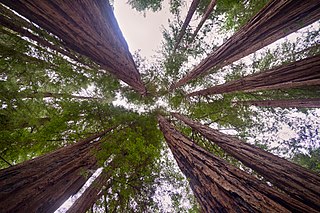
Northern California is a geographic and cultural region that generally comprises the northern portion of the U.S. state of California. Spanning the state's northernmost 48 counties, its main population centers include the San Francisco Bay Area, the Greater Sacramento area, and the Metropolitan Fresno area. Northern California also contains redwood forests, along with the Sierra Nevada, including Yosemite Valley and part of Lake Tahoe, Mount Shasta, and most of the Central Valley, one of the world's most productive agricultural regions.
The Bay Area Open Space Council is a network of 65 nonprofits and public agencies that serve tens of millions of people each year in the San Francisco Bay Area. Founded in 1990 by a group of land conservation practitioners, the Open Space Council provides information, tools, and connections for its members. Examples of member organizations include land conservation organizations, land trusts, water districts, and park districts.
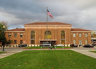
San Jose Diridon is the central passenger rail depot for San Jose, California. It also serves as a transit hub for Santa Clara County and Silicon Valley. The station is named after former Santa Clara County Supervisor Rod Diridon.

Transportation in the San Francisco Bay Area is reliant on a complex multimodal infrastructure consisting of roads, bridges, highways, rail, tunnels, airports, and bike and pedestrian paths. The development, maintenance, and operation of these different modes of transportation are overseen by various agencies, including the California Department of Transportation (Caltrans), the Association of Bay Area Governments, San Francisco Municipal Transportation Agency, and the Metropolitan Transportation Commission. These and other organizations collectively manage several interstate highways and state routes, two subway networks, two commuter rail agencies, eight trans-bay bridges, transbay ferry service, local bus service, three international airports, and an extensive network of roads, tunnels, and bike paths.

The All Nighter is a night bus service network in the San Francisco Bay Area, California. Portions of the service shadow the rapid transit and commuter rail services of BART and Caltrain, which are the major rail services between San Francisco, the East Bay, the Peninsula, and San Jose. Both BART and Caltrain do not operate owl service so that track maintenance can be performed and the All Nighter network helps fill in this service gap. The slogan is, "Now transit stays up as late as you do!"

The Santa Clara Depot is one of two heavy railway stations in Santa Clara, California. It is served by Caltrain from San Francisco, and is also served by the Altamont Corridor Express (ACE) from Stockton. This station is the planned terminal for the Silicon Valley BART extension into Santa Clara County and will be preceded by Diridon/Arena BART station with direct service to San Francisco/Daly City and Richmond.

Downtown Oakland is the central business district of Oakland, California, United States; roughly bounded by both the Oakland Estuary and Interstate 880 on the southwest, Interstate 980 on the northwest, Grand Avenue on the northeast, and Lake Merritt on the east.

San Francisco Metropolitan Area officially known as the San Francisco–Oakland–Berkeley, CA Metropolitan Statistical Area is a Metropolitan Statistical Area (MSA) within the San Francisco Bay Area, which includes a number of its core cities and counties. It is the twelfth-most populated metropolitan area in the United States. It is defined by the Office of Management and Budget to include core areas more directly economically influenced by San Francisco rather than other nearby cities such as San Jose which has its own MSA, the San Jose–Sunnyvale–Santa Clara, CA MSA. Until 2013, this MSA was known as the San Francisco–Oakland–Fremont, CA MSA, and from 2013 to 2018, the San Francisco–Oakland–Hayward, CA MSA.
The Northern California Rugby Football Union (NCRFU) is the Geographical Union (GU) for rugby union teams in Northern California, as well as northern Nevada. The NCRFU is part of USA Rugby.
The San Francisco Bay Area, popularly referred to as the Bay Area or simply the Bay, is a populous region surrounding the San Francisco, San Pablo, and Suisun Bay estuaries in Northern California. While the exact boundaries of the region are variously defined, the Bay Area is defined by the Association of Bay Area Governments to include 10 counties that border the aforementioned estuaries: Alameda, Contra Costa, Marin, Napa, San Mateo, Santa Clara, Solano, Sonoma, Santa Cruz, and San Francisco. Other boundaries may exclude parts of or even entire counties, or expand the definition to include neighboring counties that don't border the bay such as San Benito, and San Joaquin.

Throughout the history of Bay Area Rapid Transit, better known as BART, there have been plans to extend service to other areas.

The following outline is provided as an overview of and topical guide to the U.S. state of California.

Santa Clara County, officially the County of Santa Clara, is California's 6th most populous county, with a population of 1,781,642, as of the 2010 census. Santa Clara County and neighboring San Benito County together form the U.S. Census Bureau's San Jose-Sunnyvale-Santa Clara, CA Metropolitan Statistical Area, which is a component of the larger San Jose-San Francisco-Oakland, CA Combined Statistical Area. Santa Clara is the most populous county in the San Francisco Bay Area and in Northern California.
The San Jose–San Francisco–Oakland, CA Combined Statistical Area is a 14-county Combined Statistical Area (CSA) designated by the United States Office of Management and Budget in Northern California that includes the San Francisco Bay Area. The CSA is more extensive than the popular local definition of the Bay Area, which consists of only the nine counties bordering San Francisco and San Pablo Bays: Alameda, Contra Costa, Marin, Napa, San Francisco, San Mateo, Santa Clara, Solano, and Sonoma. This group of counties also elects boards for regional planning and air quality control regulation. The CSA includes Merced, San Joaquin, Santa Cruz, San Benito, and Stanislaus counties, which do not directly border the San Francisco or San Pablo bays, but are economically connected to the other nine counties that do. Merced and Stanislaus Counties were added to the CSA in September 2018.

This is a timeline of the San Francisco Bay Area in California, events in the nine counties that border on the San Francisco Bay, and the bay itself.
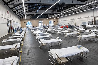
The San Francisco Bay Area, which includes the major cities of San Jose, San Francisco, and Oakland, was an early center of the COVID-19 pandemic in California. The first case of COVID-19 in the area was confirmed in Santa Clara County on January 31, 2020. A Santa Clara County resident was the earliest known death caused by COVID-19 in the United States, on February 6, suggesting that community spread of COVID-19 had been occurring long before any actual documented case. This article covers the 13 members of ABAHO, which includes the nine-county Bay Area plus the counties of Monterey, San Benito, and Santa Cruz.