Sonoma County is a county located in the U.S. state of California. As of the 2020 United States Census, its population was 488,863. Its county seat and largest city is Santa Rosa. It is to the north of Marin County and the south of Mendocino County. It is west of Napa County and Lake County.

The East Bay Regional Park District (EBRPD) is a special district operating in Alameda County and Contra Costa County, California, within the East Bay area of the San Francisco Bay Area. It maintains and operates a system of regional parks which is the largest urban regional park district in the United States. The administrative office is located in Oakland.
The Bay Area Ridge Trail is a planned 550-mile (890 km) multi-use trail along the hill and mountain ridgelines ringing the San Francisco Bay Area, in Northern California. Currently, 400 miles (640 km) have been established. When complete, the trail will connect over 75 parks and open spaces. The trail is being designed to provide access for hikers, runners, mountain bicyclists, and equestrians. It will be accessible through trailheads near major population centers, while the trail will extend into more remote areas. The first trail section was dedicated on May 13, 1989.

Tallman Mountain State Park is a 687-acre (2.78 km2) state park in Rockland County, New York, located adjacent to the Hudson River in the Town of Orangetown just south of Piermont. It is part of the Palisades Interstate Park System.

Mandalay State Beach is a protected beach in the city of Oxnard, California, United States. Managed by the California Department of Parks and Recreation, the park preserves an area of undeveloped sand dunes and wetlands that was once common along the 16.5-mile-long (26.6 km) coastline of the Oxnard Plain.
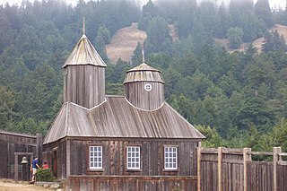
Fort Ross State Historic Park is a historical state park in Sonoma County, California, including the former Russian fur trading outpost of Fort Ross plus the adjacent coastline and native coast redwood forests extending inland. It is located on the northern California coast about 12 miles north of the town of Jenner and 22 miles north of Bodega Bay. Fort Ross, active from 1812 to 1842, was the southernmost settlement in the Russian colonization of the Americas. The 3,393-acre (1,373 ha) park was established in 1909. The site is a Sonoma County Historic Landmark.

Mount Hood, also known as Hood Mountain is a mountain near the southeastern edge of Santa Rosa, California at the northeast of the Sonoma Valley and attains a height of 2,733 feet (833 m). The original name was Mount Wilikos, an Indian name meaning "willows." Most of the drainage from Mount Hood contributes to the headwaters of Sonoma Creek. A prominent feature is the extensive rock face visible on the upper half of the mountain as viewed from State Route 12. The habitats on the mountain include mixed oak forest, pygmy forest, chaparral and riparian zones. In prehistoric times the slopes of Mount Hood were inhabited by a division of the Yuki tribe. Most of Mount Hood is within the Hood Mountain Regional Park maintained by Sonoma County. Mount Hood is part of the inner coast Mayacamas Range, and lies mostly within Sonoma County, with a part of the mountain geographically within Napa County. Mount Hood affords overlooks of the Pacific Ocean, San Francisco Bay and "a spectacular view east to the Sierra Nevada Range."

Sonoma Coast State Park is a State of California property in Sonoma County consisting of public access use on lands adjoining the Pacific Ocean. This extent of beach runs from a coastal point about 4 miles (6 km) north of Jenner and continues for approximately 17 miles (27 km) to the south to terminate at Bodega Head. The property lies along State Route 1 and consists of a number of named beaches including Arched Rock Beach, Gleason Beach and Goat Rock Beach. The ecosystem consists of alternating sandy beaches and rocky shoreline, with a marine terrace extending above the entire extent with an upland California coastal prairie habitat.

Sonoma Mountain is a prominent landform within the Sonoma Mountains of southern Sonoma County, California. At an elevation of 2,463 ft (751 m), Sonoma Mountain offers expansive views of the Pacific Ocean to the west and the Sonoma Valley to the east. In fact, the viticultural area extends in isolated patches up the eastern slopes of Sonoma Mountain to almost 1,700 feet (520 m) in elevation.

Taylor Mountain is a summit at the northern extreme of the Sonoma Mountains in California. The mountain lies in the Laguna de Santa Rosa drainage basin; its east flank drains to Matanzas Creek, a northwestward flowing stream running the length of Bennett Valley, and its west flank drains to Five Creek. The mountain is named after California Gold Rush pioneer John Shackleford Taylor, who settled on the mountain slopes in 1853 to raise dairy cows and plant a vineyard.

Sugarloaf Ridge State Park is a state park in Northern California, United States. Located in the Mayacamas Mountains north of Kenwood, the park straddles the boundary between Sonoma and Napa counties. The park contains the 2,729-foot (832 m) Bald Mountain and the headwaters of Sonoma Creek including a 25-foot (8 m) tall seasonal waterfall. The park is also home to the volunteer-run Robert Ferguson Observatory. Camping, picnicking, horseback riding, mountain biking, stargazing, fishing and hiking are common attractions of Sugarloaf. The park boasts 25 miles of trails with trails ranging from less than a mile to 8.8 miles, and elevation gains reaching 2,500 feet.

Crane Creek is a stream in Sonoma County, California, United States which rises in the northern Sonoma Mountains. This watercourse flows through Crane Canyon and the Crane Creek Regional Park situated on the northwestern flank of Sonoma Mountain. Crane Creek forms a confluence with Hinebaugh Creek in the city of Rohnert Park; thereafter, the channelized Hinebaugh Creek flows westerly to discharge to the Laguna de Santa Rosa. Hiking access to the upper Crane Creek reaches is from Roberts Road off Petaluma Hill Road.
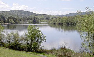
Spring Lake Regional Park is a 320-acre (130 ha) public park in southeastern Santa Rosa, Sonoma County, California, United States. Centered on the Santa Rosa Creek Reservoir, the park is administered by the Sonoma County Regional Parks Department. Its coordinates are 38.45°N 122.65°W, and its official address is 391 Violetti Drive.

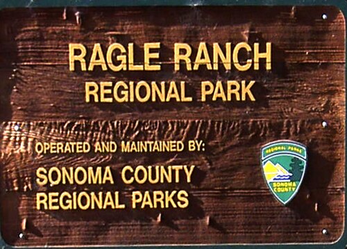
Ragle Ranch Regional Park is a regional park in Sebastopol, California, U.S.A. that is maintained by the Sonoma County Regional Parks Department. It covers an area of 157 acres (64 ha) on the west side of town. The park entrance is at 500 Ragle Road, and the day use fee is $7 per vehicle.
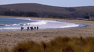
Doran Regional Park is a regional park south of Bodega Bay, California, U.S.A. that is maintained by the Sonoma County Regional Parks Department. It covers an area of 127 acres (51 ha). It is located at 38.314°N 123.0428°W on the sand spit separating Bodega Harbor from Bodega Bay. The park address is 201 Doran Beach Road, Bodega Bay, CA.
Black Point is a cape on the Pacific Coast of northern California in the United States. It is located in the Sea Ranch area of Sonoma County, approximately 80 miles (130 km) northwest of San Francisco and approximately 40 miles (60 km) northwest of Santa Rosa.
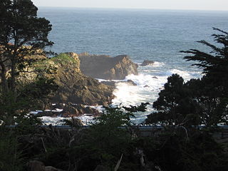
Stillwater Cove Regional Park is a regional park north of Jenner, California, U.S.A. that is maintained by the Sonoma County Regional Parks Department. It is located near the mouth of Stockhoff Creek. Access is by means of State Route 1. It was one of the filming locations for 20th Century Fox's 1947 fantasy film, The Ghost and Mrs. Muir.
Gualala Point Regional Park is a regional park on Gualala Point at the mouth of the Gualala River in Sonoma County, California, south of Gualala. The 103-acre (42 ha) park is maintained by the Sonoma County Regional Parks Department.

Stewarts Point State Marine Reserve (SMR) and Stewarts Point State Marine Conservation Area (SMCA) are two adjoining marine protected areas that extend offshore from about a mile south of Black Point to Fisk Mill Cove, in Sonoma County on California’s north central coast. The marine protected areas cover 25.22 square miles. Stewarts Point SMR prohibits the take of all living marine resources. Stewarts Point SMCA prohibits the take of all living marine resources, except recreational shore based take of marine aquatic plants, marine invertebrates, finfish by hook and line, surf smelt by beach net, and species authorized by Title 14 Section 28.80 by hand-held dip net.

Pinnacle Gulch and Shorttail Gulch are coastal access trails served by the same Sonoma County Regional Parks Department parking lot. The trails provide beach and tidepool access to the Pacific Coast of northern California in the United States. The trails are located south of Bodega Bay in Sonoma County. Automobile access from California State Route 1 is via Harbor Way just south of downtown Bodega Bay, California. A fee or Sonoma County Regional Parks pass is required for use of the trail head parking lot and rest room.