Tilden Regional Park, also known as Tilden Park or Tilden, is a 2,079-acre (841 ha) regional park in the East Bay, part of the San Francisco Bay Area in California. It is between the Berkeley Hills and San Pablo Ridge. Its main entrance is near Kensington, Berkeley, and Richmond. The park is contiguous with Wildcat Canyon Regional Park.

The East Bay Regional Park District (EBRPD) is a special district operating in Alameda County and Contra Costa County, California, within the East Bay area of the San Francisco Bay Area. It maintains and operates a system of regional parks which is the largest urban regional park district in the United States. The administrative office is located in Oakland.

Amelia Earhart Park is a 515-acre (208.41 ha) urban park in unincorporated Miami-Dade County, just north of Hialeah, Florida. It offers a number of recreational attractions like bike trails, skateboarding, and fishing.

Three Rivers Park District is a special park district serving the suburban areas of the Twin Cities including suburban Hennepin, Carver, Dakota, Scott and Ramsey counties. Three Rivers's mission is "To promote environmental stewardship through recreation and education in a natural resources-based park system." Three Rivers operates twenty parks and ten regional trails, with at least two more regional trails planned. Nearly seven million people visit Three Rivers facilities each year.
Lebanon Hills Regional Park is located in the Minnesota cities of Eagan and Apple Valley. The 1,869-acre (7.56 km2) park, the largest in Dakota County, contains forests, grasslands, marshes, and wetlands. Winter activities include skiing, snowshoeing, ice skating, ice fishing, hiking, and winter mountain biking. Summer activities include mountain biking, canoeing, kayaking, swimming, camping, horseback riding, and hiking.

Mount Hood, also known as Hood Mountain is a mountain near the southeastern edge of Santa Rosa, California at the northeast of the Sonoma Valley and attains a height of 2,733 feet (833 m). The original name was Mount Wilikos, an Indian name meaning "willows." Most of the drainage from Mount Hood contributes to the headwaters of Sonoma Creek. A prominent feature is the extensive rock face visible on the upper half of the mountain as viewed from State Route 12. The habitats on the mountain include mixed oak forest, pygmy forest, chaparral and riparian zones. In prehistoric times the slopes of Mount Hood were inhabited by a division of the Yuki tribe. Most of Mount Hood is within the Hood Mountain Regional Park maintained by Sonoma County. Mount Hood is part of the inner coast Mayacamas Range, and lies mostly within Sonoma County, with a part of the mountain geographically within Napa County. Mount Hood affords overlooks of the Pacific Ocean, San Francisco Bay and "a spectacular view east to the Sierra Nevada Range."

Sonoma Mountain is a prominent landform within the Sonoma Mountains of southern Sonoma County, California. At elevation of 2,463 ft (751 m), Sonoma Mountain offers expansive views of the Pacific Ocean to the west and the Sonoma Valley to the east. In fact, the viticultural area extends in isolated patches up the eastern slopes of Sonoma Mountain to almost 1,700 feet (520 m) in elevation.
The Ma and Pa Trail is a 6.25-mile (10.1 km) multi-purpose rail trail that follows the path of the old Ma and Pa Railroad through Harford County, Maryland. It contains three linked trails, one unconnected, with plans to bridge the gap in the middle, bringing the total length to 10 miles (16 km). Both links of the trail are paved, have few steep hills or hazards, and contain overlooks and bridges when necessary.

Saddle River County Park is a 596-acre (2.41 km2) county park in Bergen County, New Jersey, United States, stretching from Ridgewood to Rochelle Park, and extends out to Glen Rock. The park is located along the Saddle River and consists of five sections, all of which are connected by a paved path that is open to both pedestrians and bicyclists.
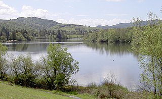
Spring Lake Regional Park is a 320-acre (130 ha) public park in southeastern Santa Rosa, Sonoma County, California, United States. Centered on the Santa Rosa Creek Reservoir, the park is administered by the Sonoma County Regional Parks Department. Its coordinates are 38.45°N 122.65°W, and its official address is 391 Violetti Drive.

Atascadero Creek is an 8.8-mile-long (14.2 km) north-flowing stream in Sonoma County, California, United States, which empties into Green Valley Creek.
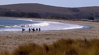
Doran Regional Park is a regional park south of Bodega Bay, California, U.S.A. that is maintained by the Sonoma County Regional Parks Department. It covers an area of 127 acres (51 ha). It is located at 38.314°N 123.0428°W on the sand spit separating Bodega Harbor from Bodega Bay. The park address is 201 Doran Beach Road, Bodega Bay, CA.

The Jordan River Parkway is an approximately 40-mile (64 km) urban park that runs along the Jordan River within the U.S. state of Utah. The parkway follows along the river from Utah Lake in Utah County, through Salt Lake County and onto the Great Salt Lake in Davis County. The majority of a mixed-use trail has been completed with a shared-use path for cyclists, skaters, and joggers. A separate equestrian path runs on the southern portion of the trail. Many trail-heads, city and county parks and golf courses are also located along the parkway.

Gualala Point Regional Park is a regional park on Gualala Point at the mouth of the Gualala River in Sonoma County, California, south of Gualala. The 103-acre (42 ha) park is maintained by the Sonoma County Regional Parks Department. The park address is 42401 State Route 1, Sea Ranch, California at milepost 58.50.
The Palmer Bikeway is a system of trails in Palmer Township, Pennsylvania. These include a towpath adjacent to the Lehigh River, along with extensions that go up through residential areas of the township. The bikeway is connected to other trails which extend into the cities of Easton and Bethlehem, and goes through a corner of Wilson Borough. The northern portion of the trail, which extends from Penn Pump Park to Tatamy Borough parallel to the Bushkill Creek, will eventually be linked to the rest of the Bikeway via an unbuilt section between Northwood Avenue and Bushkill Park Drive. Once an undeveloped portion of trail between Tatamy and Stockertown Borough is completed, the Palmer Bikeway will connect with the Plainfield Township Trail, creating a regional trail system.

There are a wide range of recreational areas and facilities in Colorado Springs, Colorado.
The Loop is a network of shared-use paths in metropolitan Tucson, Arizona maintained by Pima County. Once complete it will comprise 131 miles (211 km) of paved trails dedicated to cyclist, pedestrian, and equestrian use. By 2014, the network was 85% complete, with over one hundred miles in place. Pima County estimates the Loop is used by an average of 2,000 visitors each weekday and more than 5,000 on weekends.
Vargas Plateau Regional Park sits on a plateau in the Fremont Hills of Alameda County, California that overlooks the San Francisco Bay, Niles Canyon, and the cities of Fremont, Union City and Newark. The elevation of the park is about 1,000 feet (300 m), making it an important link with nearby ridge-top parks such as Garin Regional Park, Pleasanton Ridge Regional Park, Mission Peak Regional Preserve, and Sunol Regional Wilderness.