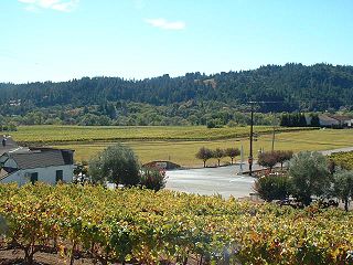
Sonoma Valley is a valley located in southeastern Sonoma County, California, in the San Francisco Bay Area. Known as the birthplace of the California wine industry, the valley is home to some of the earliest vineyards and wineries in the state, some of which survived the phylloxera epidemic of the 1870s and the impact of prohibition in the early 20th century. Today, the valley's wines are protected by the US Federal Government's Sonoma Valley and Carneros AVAs.
Saratoga Gap Open Space Preserve is a 1540-acre regional park located near Saratoga Gap in the Santa Cruz Mountains of Santa Clara County, California. The preserve is owned and operated by the Midpeninsula Regional Open Space District. The preserve contains about 2 miles (3 km) of hiking trails, which are open to equestrians and bicycles.

Sonoma Mountain is a prominent landform within the Sonoma Mountains of southern Sonoma County, California. At elevation of 2,463 ft (751 m), Sonoma Mountain offers expansive views of the Pacific Ocean to the west and the Sonoma Valley to the east. In fact, the viticultural area extends in isolated patches up the eastern slopes of Sonoma Mountain to almost 1,700 feet (520 m) in elevation.
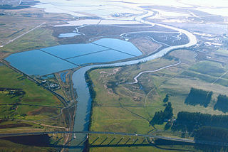
The Napa Sonoma Marsh is a wetland at the northern edge of San Pablo Bay, which is a northern arm of the San Francisco Bay in California, United States. This marsh has an area of 48,000 acres (194 km2), of which 13,000 acres (53 km2) are abandoned salt evaporation ponds. The United States Government has designated 13,000 acres (53 km2) in the Napa Sonoma Marsh as the San Pablo Bay National Wildlife Refuge.

Middle Harbor Shoreline Park (MHSP) is located on San Francisco Bay and the Port of Oakland entrance channel, west of downtown Oakland, California. It is owned and operated by the Port of Oakland. The park entrance is at the intersection of 7th and Middle Harbor Streets. It is open seven days a week from 8 a.m. to dusk.

Radke Martinez Regional Shoreline (RMRS) is a regional park on the shoreline of Carquinez Strait in Martinez, located in northern Contra Costa County, California. Formerly known as the Martinez Regional Shoreline, it was renamed on December 6, 2016, in honor of the late Ted Radke and his late wife Kathy Radke.

The Bear Creek Greenway is a 17.9-mile (28.8 km) biking and hiking path extending from Ashland to Central Point in the U.S. state of Oregon. Passing through Talent, Phoenix, and Medford, it roughly parallels Bear Creek, a tributary of the Rogue River. The Greenway is divided into two lanes for bi-directional traffic and is inaccessible to motor vehicles.

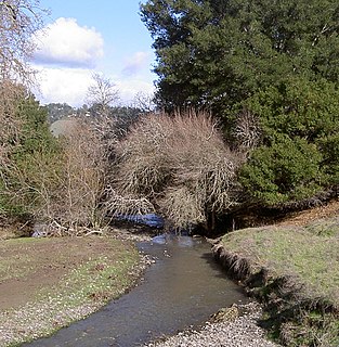
Five Creek is a westward flowing stream that rises in the city of Rohnert Park, California, United States and discharges to the Laguna de Santa Rosa. The creek is channelized as it flows through the city and runs in an artificially rectilinear fashion. Considered waters of the United States as a jurisdictional matter, Five Creek has potential habitat for the California red-legged frog and the Western pond turtle.
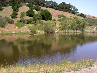
Spring Lake Regional Park is a 320-acre (130 ha) public park in southeastern Santa Rosa, Sonoma County, California, United States. Centered on the Santa Rosa Creek Reservoir, the park is administered by the Sonoma County Regional Parks Department. Its coordinates are 38.45°N 122.65°W, and its official address is 391 Violetti Drive.
The Dry Creek Valley AVA is an American Viticultural Area in Sonoma County, California, located northwest of the town of Healdsburg. The valley is formed by Dry Creek, a tributary of the Russian River, and is approximately 16 miles (25.7 km) long and 2 miles (3.2 km) wide. The appellation benefits from the proximity of the Lake Sonoma reservoir for irrigation in this relatively dry area.

The Dry Creek Rancheria is the land base of the Dry Creek Rancheria Band of Pomo Indians. The reservation consists today of approximately 75 acres (300,000 m2) near the Russian River, in Sonoma County, approximately 75 miles (121 km) north of San Francisco, California. It is situated about 3 miles southeast of Geyserville.

Ragle Ranch Regional Park is a regional park in Sebastopol, California, U.S.A. that is maintained by the Sonoma County Regional Parks Department. It covers an area of 157 acres (64 ha) on the west side of town. The park entrance is at 500 Ragle Road, and the day use fee is $7 per vehicle.
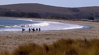
Doran Regional Park is a regional park south of Bodega Bay, California, U.S.A. that is maintained by the Sonoma County Regional Parks Department. It covers an area of 127 acres (51 ha). It is located at 38.314°N 123.0428°W on the sand spit separating Bodega Harbor from Bodega Bay. The park address is 201 Doran Beach Road, Bodega Bay, CA.
Helen Putnam Regional Park is a regional park southwest of Petaluma, California, U.S.A. which is maintained by the Sonoma County Regional Parks Department. It covers an area of 216 acres (87 ha). The park entrance is at 411 Chileno Valley Road.
Kanaka Creek Regional Park is a regional park of the Greater Vancouver Regional District, located in the District of Maple Ridge, British Columbia, flanking both sides of Kanaka Creek from its confluence with the Fraser River just east of Haney and extending approximately 11 km up the creek to just south of the community of Webster's Corners.
Rancho Bolsa de Tomales was a Mexican land grant in present day Marin County and Sonoma County, California given in 1846 by Governor Pío Pico to Juan Nepomuceno Padilla. The name means "the Pool of the Tomales Indians," which referred to Burbank’s Lake. The grant extended along the Pacific coast from Estero de San Antonio south to Walker Creek, and encompassed present day Tomales. Stemple Creek transversed the property. The land claim was rejected as fraudulent by the US Supreme Court.
Sonoma Water, formerly known as the Sonoma County Water Agency, maintains a water transmission system that provides naturally filtered Russian River water to more than 600,000 residents in portions of Sonoma County, California and Marin County, California. The Water Agency is a water wholesaler that sells potable water to nine cities and special districts that in turn sell drinking water to their residents. These cities and special districts are: the City of Santa Rosa, Rohnert Park, Cotati, Petaluma, Sonoma, the Town of Windsor, Valley of the Moon Water District, Marin Municipal Water District, and North Marin Water District.
The Marin Municipal Water District is the government agency that provides drinking water to southern and central Marin County, California. Chartered in 1912, it became California's first municipal water district.It is notorious for its current heavy disrimination against mountain bikes, despite being the birthplace of the sport. It serves 195,000 people in a 147-square-mile (380 km2) area that includes ten towns and cities.

Bear Creek Regional Park and Nature Center is a regional park located in Colorado Springs, Colorado that has trails for hiking, horseback riding, running and cycling. Within the park is a nature center and the El Paso Park Headquarters.