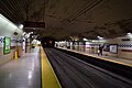
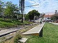
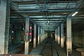
List of Muni Metro stations

Last updated

Muni Metro map accurate to January 2023. Only accessible stops are labeled; S Shuttle service is not shown. L Taraval is currently served by buses.
.mw-parser-output figure[typeof="mw:File/Thumb"] .image-key>ol{margin-left:1.3em;margin-top:0}.mw-parser-output figure[typeof="mw:File/Thumb"] .image-key>ul{margin-top:0}.mw-parser-output figure[typeof="mw:File/Thumb"] .image-key li{page-break-inside:avoid;break-inside:avoid-column}@media(min-width:300px){.mw-parser-output figure[typeof="mw:File/Thumb"] .image-key,.mw-parser-output figure[typeof="mw:File/Thumb"] .image-key-wide{column-count:2}.mw-parser-output figure[typeof="mw:File/Thumb"] .image-key-narrow{column-count:1}}@media(min-width:450px){.mw-parser-output figure[typeof="mw:File/Thumb"] .image-key-wide{column-count:3}}
.mw-parser-output .plainlist ol,.mw-parser-output .plainlist ul{line-height:inherit;list-style:none;margin:0;padding:0}.mw-parser-output .plainlist ol li,.mw-parser-output .plainlist ul li{margin-bottom:0}
J Church
K Ingleside
L Taraval - (bus substitution)
M Ocean View
N Judah
T Third Street Muni Metro map (2023-01-07).png
Muni Metro map accurate to January 2023. Only accessible stops are labeled; S Shuttle service is not shown. L Taraval is currently served by buses.

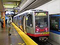
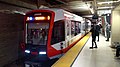
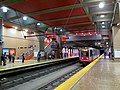
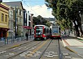
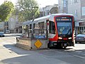
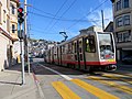
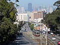
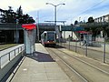
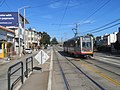
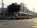
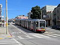
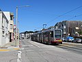
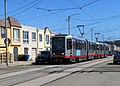
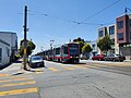
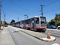
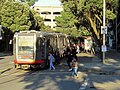
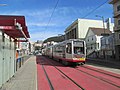
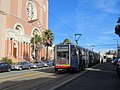
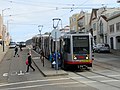
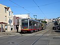
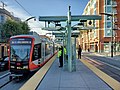
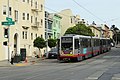
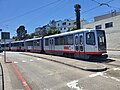
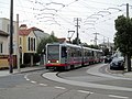
Muni Metro is a light rail system serving San Francisco, California, United States. Operated by the San Francisco Municipal Railway (Muni), a part of the San Francisco Municipal Transportation Agency (SFMTA), Muni Metro served an average of 157,700 passengers per weekday in the fourth quarter of 2019, making it the second-busiest light rail system in the United States. Six services – J Church, K Ingleside, L Taraval, M Ocean View, N Judah, and T Third Street run on separate surface alignments and merge into a single downtown tunnel. The supplementary S Shuttle service operates within the tunnel. Muni Metro operates a fleet of 151 Breda high-floor light rail vehicles (LRVs), which are currently being replaced by a fleet of 249 Siemens S200 LRVs.

Contents

The San Francisco Municipal Railway was created in 1909 and opened its first streetcar lines in 1912. Five of the current lines were added in the following decades: the J in 1917, the K (including the Twin Peaks Tunnel) in 1918, the L in 1919, the M in 1925, and the N in 1928. [1] The other Municipal Railway streetcar lines, and those of the privately owned Market Street Railway, were converted to buses in the 1920s to 1950s, but these five lines were retained as streetcars because of their private rights of way. The system was converted to light rail, with larger US Standard Light Rail Vehicles, in the late 1970s and early 1980s. This included the opening of the Market Street subway as well as extension of three lines to Balboa Park station. [1] An extension along The Embarcadero to the Caltrain terminal at 4th and King Street opened in 1998. [2] [3] The T Third Street line opened in 2007, serving the southeastern portion of the city. [4] The Central Subway, with three new subway stations and one new surface station, opened on November 19, 2022. [5]
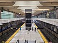
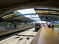
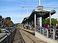
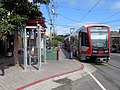
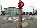
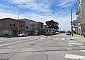
The system has 113 stations, of which 59 (52%) are accessible. All nine subway stations plus 24 surface stations have high-level platforms, 34-inch (860 mm) high, that allow for accessible level boarding at all doors. [6] The other 80 stations have a mixture of low-level platforms on dedicated right-of-way, low-level boarding islands (platforms between the tracks and traffic lanes), sidewalk bulbs, and no platforms (where passengers cross parking or traffic lanes to board). Of those 80, 25 have "mini-high" platforms providing accessible boarding at a single door, while one has a wheelchair lift. Three stations on the L Taraval are being retrofitted with mini-high platforms as part of a reconstruction project.

Current stations

Bart-logo.svg / Caltrain roundel.svg Transfer stations with BART / Caltrain
Bart-logo.svg / Caltrain roundel.svg Transfer stations with BART / Caltrain, and Line termini
Line termini

Future stations

StationImageLine(s)PlatformsScheduled opening
Ulloa and 14th Avenue Inbound train passing Ulloa and 14th Avenue, February 2019.JPG None2024 [8]

Former stations

Prior to the late 1970s, there was a higher density of stops on the surface streetcar lines. Many of these stops were closed as the conversion to Muni Metro introduced longer trains and a desire for higher surface speeds. Most were had no infrastructure other than marked poles at street corners; several on the M Ocean View had small platforms. A number of stops on Market Street were closed when the Market Street subway opened; most are now served by the F Market & Wharves streetcar. Four stations with significant infrastructure were closed during conversion:

StationImageLine(s)Service endedPlatformsNotes
Church and 19th Street 19th Street footbridge and former Muni station, May 2018.JPG c.1980Low-level side platformsInside Dolores Park
Eureka Valley Eureka Valley station remains, September 19, 2015.jpg 1972 [1] Low-level side platforms (subway station)
Phelan Loop Phelan Loop, circa 2002.jpg March 17, 1981 [1] Low-level side platformReplaced by Ocean and Lee
Transbay Terminal 1939TransbayTerminal-in-2008.jpg September 20, 1982 [1] Low-level side platformsStreetcar loop on the north side of the terminal, separate from the elevated bus loops formerly used by Transbay trains

Several surface stops have closed during the Muni Metro era during station consolidation projects.

StationImageLine(s)Service endedPlatformsNotes
Irving and 4th Avenue Outbound train at Irving and 4th Avenue, January 2018.JPG March 30, 2020 [9] [10] NoneConsolidated into Irving and 5th Avenue / Irving and 6th Avenue
Irving and 7th Avenue Inbound train at Irving and 7th Avenue, September 2019.JPG March 30, 2020 [9] [10] NoneConsolidated into Irving and 5th Avenue / Irving and 6th Avenue
Taraval and 28th Avenue Taraval and 28th Avenue with stop closure notice, June 2017.JPG February 25, 2017 [11] None
Taraval and 35th Avenue Inbound train at Taraval and 35th Avenue, May 2018.JPG February 10, 2018 [12] None
Ulloa and 15th Avenue Inbound train at Ulloa & 15th, June 2017.JPG February 25, 2017 [11] NoneConsolidated into Ulloa and 14th Avenue
Ulloa and Forest Side L Taraval train at Ulloa Street & Forest Side Avenue, June 2017.JPG c.2022NoneConsolidated into Ulloa and 14th Avenue

Related Research Articles

<span class="mw-page-title-main">San Francisco Municipal Railway</span> Public transport agency in San Francisco, California, USA

The San Francisco Municipal Railway ( MEW-nee; SF Muni or Muni), is the primary public transit system within San Francisco, California. It operates a system of bus routes, the Muni Metro light rail system, three historic cable car lines, and two historic streetcar lines. Previously an independent agency, the San Francisco Municipal Railway merged with two other agencies in 1999 to become the San Francisco Municipal Transportation Agency (SFMTA). In 2018, Muni served 46.7 square miles (121 km2) with an operating budget of about $1.2 billion. Muni is the seventh-highest-ridership transit system in the United States, with 142,168,200 rides in 2023, and the second-highest in California after the Los Angeles County Metropolitan Transportation Authority.

<span class="mw-page-title-main">Muni Metro</span> Light rail system in San Francisco, California

Muni Metro is a semi-metro system serving San Francisco, California, United States. Operated by the San Francisco Municipal Railway (Muni), a part of the San Francisco Municipal Transportation Agency (SFMTA), Muni's light rail lines saw an average of 75,500 boardings per day as of the first quarter of 2024 and a total of 24,324,600 boardings in 2023, making it the sixth-busiest light rail system in the United States.

<span class="mw-page-title-main">N Judah</span> Light rail line in San Francisco, California

The N Judah is a hybrid light rail/streetcar line of the Muni Metro system in San Francisco, California. The line is named after Judah Street that it runs along for much of its length, named after railroad engineer Theodore Judah. It links downtown San Francisco to the Cole Valley and Sunset neighborhoods. The line provides rail access to Golden Gate Park. It is the busiest line in the Muni Metro system, serving an average of 41,439 weekday passengers in 2013. It was one of San Francisco's streetcar lines, beginning operation in 1928, and was partially converted to modern light-rail operation with the opening of the Muni Metro system in 1980. While many streetcar lines were converted to bus lines after World War II, the N Judah remained a streetcar line due to its use of the Sunset Tunnel.

<span class="mw-page-title-main">L Taraval</span> Light rail line in San Francisco, California

The L Taraval is a hybrid light rail/streetcar line of the Muni Metro system in San Francisco, California, mainly serving the Parkside District. Since 2021, the line has been suspended and replaced by buses until the end of 2024 for an improvement project along Taraval Street.

<span class="mw-page-title-main">M Ocean View</span> Light rail line in San Francisco, California

The M Ocean View is a light rail line that is part of the Muni Metro system in San Francisco, California. Named after the Oceanview neighborhood, it runs between San Jose and Geneva and Embarcadero station, connecting Oceanview, San Francisco State University, and Stonestown Galleria with the city center. The line opened on October 6, 1925.

<span class="mw-page-title-main">K Ingleside</span> Light rail line in San Francisco, California

The K Ingleside is a hybrid light rail/streetcar line of the Muni Metro system in San Francisco, California. It mainly serves the West Portal and Ingleside neighborhoods. The line opened on February 3, 1918, and was the first line to use the Twin Peaks Tunnel.

<span class="mw-page-title-main">J Church</span> Light rail line in San Francisco, California

The J Church is a hybrid light rail/streetcar line of the Muni Metro system in San Francisco, California. The line runs between Embarcadero station and Balboa Park station through Noe Valley. Opened on August 11, 1917, it is the oldest and has the lowest ridership of all of the Muni Metro lines.

<span class="mw-page-title-main">S Shuttle</span> Light rail service in San Francisco, California

The S Shuttle is a light rail service on the Muni Metro system in San Francisco, California. The service began in 2001 as the S Castro Shuttle, an effort to reduce crowding at Castro station. It was briefly discontinued in 2007 when the T Third Street line was opened. Service was extended to St. Francis Circle station in 2013, but cut back to West Portal station in 2016. In 2020, it was changed to full-time service as part of a reconfiguration of Muni Metro service.

<span class="mw-page-title-main">West Portal station</span> Light rail stop in San Francisco

West Portal station is a Muni Metro station in the West Portal neighborhood in San Francisco, California. It is built around the western entrance to the Twin Peaks Tunnel. The station consists of two side platforms, with the entrance at the western end. A non-accessible footbridge connects the platforms inside fare control.

<span class="mw-page-title-main">Market Street subway</span> BART-Muni Metro main line, San Francisco

The Market Street subway is a two-level subway tunnel that carries Muni Metro and BART trains under Market Street in San Francisco, California. It runs under the length of Market Street between Embarcadero station and Castro station. The upper level is used by Muni Metro lines and the lower level is used by BART lines. BART does not run through the whole subway; it turns south and runs under Mission Street southwest of Civic Center/UN Plaza station. The northeastern end of the BART level is connected to the Transbay Tube. On the Muni Metro level, the southwestern end of the Market Street subway connects to the much-older Twin Peaks Tunnel, and the northeastern end connects to surface tracks along the Embarcadero.

<span class="mw-page-title-main">T Third Street</span> Light rail line in San Francisco, California

The T Third Street is a Muni Metro light rail line in San Francisco, California. It runs along the east side of San Francisco from Sunnydale to Chinatown, traveling in the median of Third Street for most of its length before entering the Central Subway as it approaches downtown. The line serves 22 stations, all of which are accessible. Most of the surface portion of the line runs in dedicated median lanes, though two portions operate in mixed traffic.

<span class="mw-page-title-main">E Embarcadero</span> San Francisco heritage streetcar line

The E Embarcadero is a historic streetcar line that is the San Francisco Municipal Railway's second heritage streetcar line in San Francisco, California. Trial service first ran during the Sunday Streets events on The Embarcadero in 2008. The line initially ran on weekends only, but expanded to weeklong service in late April 2016.

<span class="mw-page-title-main">San Francisco 4th and King Street station</span> Train station in San Francisco, California, U.S.

San Francisco 4th and King Street station, also known as the Caltrain Depot, is a train station in the SoMa district of San Francisco, California. It is presently the northern terminus of the Caltrain commuter rail line serving the San Francisco Peninsula and Santa Clara Valley. It is also the eastern terminus of the N Judah and E Embarcadero, as well as a stop along the T Third Street of the Muni network. The station is additionally the projected terminus for the first phase of the California High-Speed Rail project and a station once Phase 2 is completed.

<span class="mw-page-title-main">The Embarcadero and Folsom station</span>

The Embarcadero and Folsom station is a Muni Metro light rail station located in the median of The Embarcadero between Folsom Street and Harrison Street in the Rincon Hill area of San Francisco, California. Muni Metro trains use a high-level island platform, while historic streetcars use a pair of side platforms at the southeast end of the station next to the Harrison Street grade crossing.

<span class="mw-page-title-main">The Embarcadero and Brannan station</span>

Brannan and The Embarcadero station is a Muni Metro light rail station located in the median of The Embarcadero south of Brannan Street in the South Beach area of San Francisco, California. Muni Metro trains use a high-level island platform, while historic streetcars use a pair of side platforms at the south end of the station.

<span class="mw-page-title-main">2nd and King station</span> Light rail station in San Francisco, California

2nd and King station is a Muni Metro light rail station located in the median of King Street near Second Street in the China Basin neighborhood of San Francisco, California. It is adjacent to Oracle Park. Muni Metro trains use a high-level island platform, while historic streetcars use a pair of side platforms just to the south.

<span class="mw-page-title-main">Duboce and Church station</span>

Duboce and Church is a light rail stop on the Muni Metro J Church and N Judah lines, located in the Duboce Triangle neighborhood of San Francisco, California. Just east of the station, the two lines enter the Market Street subway. The stop originally opened with the 22 Fillmore line in 1895. The station has complex layout with two side platforms in the middle of Duboce Avenue for the N Judah, one side platform in the middle of Church Street for northbound J Church trains entering the Market Street subway, and two mini-high platforms at the subway portal which provides access to both lines for people with disabilities.

<span class="mw-page-title-main">Taraval and 22nd Avenue / Taraval and 23rd Avenue stations</span>

Taraval and 22nd Avenue / Taraval and 23rd Avenue stations are a pair of light rail stops on the Muni Metro L Taraval line, located in the Parkside neighborhood of San Francisco, California. The eastbound stop is located on Taraval Street and 22nd Avenue, while westbound trains stop on Taraval Street at 23rd Avenue.

<span class="mw-page-title-main">Siemens S200</span> High-floor light rail transit vehicle

The Siemens S200 is a high-floor light rail vehicle (LRV) manufactured by Siemens Mobility in Florin, California, beginning service in 2016.

References

  1. 1 2 3 4 5 Callwell, Robert (September 1999). "Transit in San Francisco: A Selected Chronology, 1850–1995" (PDF). San Francisco Municipal Railway.
  2. Epstein, Edward (November 4, 1997). "Muni Metro Line Set To Open in January". San Francisco Chronicle. Retrieved January 22, 2009.
  3. Epstein, Edward (January 9, 1998). "Muni's Embarcadero Streetcar Line Set to Make First Runs". San Francisco Chronicle. Retrieved January 14, 2009.
  4. "New T-Third Service". San Francisco Municipal Transportation Agency. Archived from the original on May 11, 2008. Retrieved January 14, 2009.
  5. "SFMTA Announces Opening Schedule of the Central Subway Project" (Press release). San Francisco Municipal Transportation Agency. September 20, 2022. Archived from the original on August 11, 2023. Retrieved September 27, 2022.
  6. "S200 SF Light Rail Vehicle" (PDF). Siemens. Retrieved 18 May 2016.
  7. "Chapter 1". Muni Metro Turnaround Project: Final Environmental Impact Statement. United States Department of Transportation Urban Mass Transportation Administration. August 1989. p. 1-2 via Internet Archive.
  8. Maguire, Mariana (August 18, 2020). "Major Muni Service Expansion August 22" (Press release). San Francisco Municipal Transportation Agency. Archived from the original on November 6, 2021. Retrieved November 29, 2021.
  9. 1 2 Fowler, Amy (March 26, 2020). "Starting March 30: New Muni Service Changes" (Press release). San Francisco Municipal Transportation Agency.
  10. 1 2 "Permanent Stop Changes Starting Saturday, August 22, 2020" (Press release). San Francisco Municipal Transportation Agency. August 2020. Archived from the original on September 28, 2022. Retrieved September 28, 2022.
  11. 1 2 Hyden, Rachel (February 17, 2017). "More Muni Forward Service Improvements Roll Out February 25" (Press release). San Francisco Municipal Transportation Agency. Archived from the original on September 11, 2017. Retrieved September 28, 2022.
  12. "Upcoming Changes to Transit Service: February 10 & 20, 2018". San Francisco Municipal Transportation Agency. February 10, 2018. Archived from the original on February 15, 2018. Retrieved September 28, 2022.

Commons-logo.svg Media related to Muni Metro stations at Wikimedia Commons