
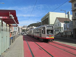
The N Judah is a hybrid light rail/streetcar line of the Muni Metro system in San Francisco, California. The line is named after Judah Street that it runs along for much of its length, named after railroad engineer Theodore Judah. It links downtown San Francisco to the Cole Valley and Sunset neighborhoods. It is the busiest line in the Muni Metro system, serving an average of 41,439 weekday passengers in 2013. It was one of San Francisco's streetcar lines, beginning operation in 1928, and was partially converted to modern light-rail operation with the opening of the Muni Metro system in 1980. While many streetcar lines were converted to bus lines after World War II, the N Judah remained a streetcar line due to its use of the Sunset Tunnel.

The J Church is a hybrid light rail/streetcar line of the Muni Metro system in San Francisco, California. The line runs between Embarcadero station and Balboa Park station through Noe Valley. Opened on August 11, 1917, it is the oldest and has the lowest ridership of all of the Muni Metro lines.

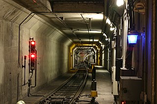
The Sunset Tunnel, originally known as the Duboce Tunnel, is a 4,232 ft (1,290 m)-long light rail/streetcar tunnel in San Francisco, California. The tunnel runs under the steep hill adjacent to Buena Vista Park and is used exclusively by the N Judah Muni Metro line.
The Market Street subway is a two-level subway tunnel that carries Muni Metro and BART trains under Market Street in San Francisco, California. It runs under the length of Market Street between Embarcadero station and Castro station. The upper level is used by Muni Metro lines and the lower level is used by BART lines. BART does not run through the whole subway; it turns south and runs under Mission Street southwest of Civic Center/UN Plaza station. The northeastern end of the BART level is connected to the Transbay Tube. On the Muni Metro level, the southwestern end of the Market Street subway connects to the much-older Twin Peaks Tunnel, and the northeastern end connects to surface tracks along the Embarcadero.

San Francisco 4th and King Street station, or Caltrain Depot is a train station in the SoMa district of San Francisco, California. It is presently the northern terminus of the Caltrain commuter rail line serving the San Francisco Peninsula and Santa Clara Valley. It is also the eastern terminus of the N Judah and E Embarcadero, as well as a stop along the T Third Street of the Muni network. The station is additionally the projected terminus for the first phase of the California High-Speed Rail project and a station once Phase 2 is completed.

Duboce and Church is a light rail stop on the Muni Metro J Church and N Judah lines, located in the Duboce Triangle neighborhood of San Francisco, California. Just east of the station, the two lines enter the Market Street subway. The stop originally opened with the 22 Fillmore line in 1895. The station has complex layout with two side platforms in the middle of Duboce Avenue for the N Judah, one side platform in the middle of Church Street for northbound J Church trains entering the Market Street subway, and two mini-high platforms at the subway portal which provides access to both lines for people with disabilities.

Carl and Cole station is a light rail stop on the Muni Metro N Judah line, located in the Cole Valley neighborhood of San Francisco, California. The western portal of the Sunset Tunnel is located just east of the station. The station opened with the N Judah line on October 21, 1928.

Carl and Stanyan station is a light rail stop on the Muni Metro N Judah line, located in the Cole Valley neighborhood of San Francisco, California. The station opened with the N Judah line on October 21, 1928. It is located two blocks away from Kezar Stadium. The has a transit bulb in the eastbound direction, which extends the sidewalk of Carl Street, to meet trains like a side platform, allowing passengers to board or depart from trains. In the westbound direction, passengers wait on the sidewalk and cross a lane of traffic to board trains. The station is not accessible to people with disabilities.

Irving and 8th Avenue / 9th Avenue and Irving stations are a pair of one-way light rail stops on the Muni Metro N Judah line, located in the Sunset District neighborhood of San Francisco, California. The eastbound stop is located on Irving Street at 8th Avenue, while westbound trains stop on 9th Avenue at Irving Street. The station has transit bulbs which extend the sidewalk of Irving Street and 9th Avenue to meet trains like a side platform, allowing passengers to board or depart from trains. The station is not accessible to people with disabilities.
Judah and 9th Avenue is a light rail stop on the Muni Metro N Judah line, located in the Sunset District neighborhood of San Francisco, California. The station opened with the N Judah line on October 21, 1928. The station has two side platforms in the middle of Judah Street where passengers board or depart from trains. The station also has mini-high platforms providing access to people with disabilities.
Judah and 19th Avenue station is a light rail stop on the Muni Metro N Judah line, located in the Sunset District neighborhood of San Francisco, California where Judah Street crosses 19th Avenue. The station opened with the N Judah line on October 21, 1928. The station has two short side platforms in the middle of Judah Street where passengers board or depart from trains. The station also has mini-high platforms providing access to people with disabilities.

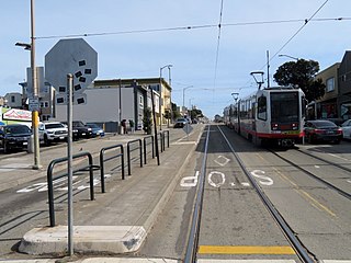
Judah and 28th Avenue is a light rail stop on the Muni Metro N Judah line, located in the Sunset District neighborhood of San Francisco, California. The stop opened with the N Judah line on October 21, 1928. The station has two side platforms in the middle of Judah Street where passengers board or depart from trains. The station also has mini-high platforms providing access to people with disabilities.

Judah and 31st Avenue station is a light rail stop on the Muni Metro N Judah line, located in the Sunset District neighborhood of San Francisco, California. The station opened with the N Judah line on October 21, 1928. The station has two short side platforms in the middle of Judah Street where passengers board or depart from trains. The station is not accessible to people with disabilities.

Judah and 34th Avenue station is a light rail stop on the Muni Metro N Judah line, located in the Sunset District neighborhood of San Francisco, California. The station opened with the N Judah line on October 21, 1928. The station has two short side platforms in the middle of Judah Street where passengers board or depart from trains. The station is not accessible to people with disabilities.
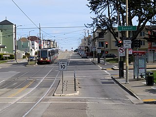
Judah and Sunset station is a light rail stop on the Muni Metro N Judah line, located in the Sunset District neighborhood of San Francisco, California. The station opened with the N Judah line on October 21, 1928. The station has two short side platforms in the middle of Judah Street where passengers board or depart from trains. The station also has mini-high platforms providing access to people with disabilities.

Judah and 40th Avenue station is a light rail stop on the Muni Metro N Judah line, located in the Sunset District neighborhood of San Francisco, California. The station opened with the N Judah line on October 21, 1928. The station has two short side platforms in the middle of Judah Street where passengers board or depart from trains. The station is not accessible to people with disabilities.

Judah and 43rd Avenue station is a light rail stop on the Muni Metro N Judah line, located in the Sunset District neighborhood of San Francisco, California. The station opened with the N Judah line on October 21, 1928. The station has two short side platforms in the middle of Judah Street where passengers board or depart from trains. The station is not accessible to people with disabilities.
Judah and 46th Avenue station is a light rail stop on the Muni Metro N Judah line, located in the Sunset District neighborhood of San Francisco, California. The station opened with the N Judah line on October 21, 1928. The station has two short side platforms in the middle of Judah Street where passengers board or depart from trains. The station is not accessible to people with disabilities.

Judah and La Playa station is a light rail stop that serves as the western terminus of the Muni Metro N Judah line. It is located in the Sunset District neighborhood adjacent to the Great Highway and Ocean Beach. The station has functioned as the terminus of the N Judah line since October 21, 1928. The station has a mini-high platform which provides access to people with disabilities, but most passengers load trains from the street, crossing a lane of traffic to reach the sidewalks.

Irving and 5th Avenue / Irving and 6th Avenue stations are a pair of light rail stops on the Muni Metro N Judah line, located in the Sunset District neighborhood of San Francisco, California. The eastbound stop is located on Irving Street at 5th Avenue, while westbound trains stop on Irving Street at 6th Avenue.

