Church station (Muni Metro)

Last updated
Muni worm logo.svg Church
S Shuttle train at Church station, December 2017.jpg
S Shuttle train at Church station in December 2017
General information
Location Market Street at Church Street and 14th Street
San Francisco, California
Coordinates 37°46′4.13″N122°25′44.64″W / 37.7678139°N 122.4290667°W / 37.7678139; -122.4290667
Owned by San Francisco Municipal Transportation Agency
Line(s) Market Street subway
Platforms2 side platforms (underground)
4 side platforms (surface)
Tracks2 (Muni Metro – underground)
2 (Muni Metro – surface)
2 (historic streetcar – surface)
ConnectionsAiga bus trans.svg Muni: 22, 37
Construction
Structure typeUnderground
AccessibleYes
ArchitectReid & Tarics Associates [1]
History
OpenedJune 11, 1980 [2]
Services
Preceding station BSicon LOGO SFmuni.svg Muni Following station
Castro
towards Balboa Park
K Ingleside Van Ness
towards Embarcadero
Castro
towards SF Zoo
L Taraval
Suspended
Castro M Ocean View
Castro
towards West Portal
S Shuttle
At surface stops
Market and Sanchez F Market & Wharves Market and Dolores / Market and Buchanan
Church and 16th Street
towards Balboa Park
J Church Church and Duboce
towards Embarcadero
Location
Church station (Muni Metro)

Church station or Church Street station is a Muni Metro light rail station in San Francisco, California. It is located at the six-way intersection of Market Street, Church Street and 14th Street in the Duboce Triangle neighborhood.

Contents

Station layout

The station consists of two side platforms next to the tracks on the second level down with the concourse mezzanine level overlooking it. At both Church Street station and Castro Street station, there is only one stairway on each side of Market Street leading into the station. (All other stations on the Market Street subway have entrances spread out along the length of the station.) One of these entrances is located on the northwest corner of Market and 14th Street, and the other is on the southwest corner of Market and Church Street. The street elevator is on the north side of Market Street west of 14th Street. Originally freestanding, it was incorporated in the façade of an apartment building constructed in 2017–2020. [3] [4]

The J Church line, which enters and exits the Market Street subway tunnel in a portal near the station, connects to this station at two surface-level platform. The inbound stop is near the corner of Church and Market Streets, while the outbound stop is near the corner of Church and 14th Streets. The F Market & Wharves streetcar line, running along Market Street, also has stops at the intersection. The N Judah line also exits the Market Street tunnel before reaching the Church Street station and stops one block away at Church and Duboce Avenue.

History

An outbound J Church train at Market Street in December 2020 Outbound J Church train leaving Market Street, December 2020.jpg
An outbound J Church train at Market Street in December 2020

The station was constructed by BART as part of the Market Street subway. The BART Board approved the name "Church Street" in December 1965. [5] Service at the station began in June 1980. The station was featured in the 1982 Nick Nolte and Eddie Murphy film 48 Hrs. [6]

As part of August 2020 changes to Muni Metro, the J became an all-surface line. The J terminated at the inbound platform on Church Street, providing an accessible transfer between the J and subway trains. [7] A mini-high platform was to be constructed on the inbound platform at Church and Duboce, and an outbound mini-high platform was to be built on Church Street south of Market Street, allowing the J to be re-extended slightly to Duboce Street in October 2020. [7] The forced transfer at Church station – which requires J Church riders to cross two streets and use two elevators to transfer – was criticized by disability advocates. [8]

However, on August 25, 2020 – just days after the changes – all Muni Metro service was again replaced by buses. [9] J Church rail service resumed on December 19, 2020, with both new mini-high platforms in use and Duboce as the new terminus. [10] [11] The platforms were painted with a mural, Them (Ramp) by Simon Malvaez, in early 2021. [12]

In 2022, new decorative railings were added on both Market Street boarding islands as part of the Upper Market Street Safety Project. They feature a quote from Harvey Milk's 1977 "You've Got to Have Hope" speech, as well as an illustration of streetcar #1051, which is dedicated in Milk's honor. [13] [14] [15]

Related Research Articles

<span class="mw-page-title-main">Muni Metro</span> Light rail system in San Francisco

Muni Metro is a semi-metro system serving San Francisco, California, United States. Operated by the San Francisco Municipal Railway (Muni), a part of the San Francisco Municipal Transportation Agency (SFMTA), Muni's light rail lines saw an average of 75,500 boardings per day as of the fourth quarter of 2023 and a total of 24,324,600 boardings in 2023, making it the sixth-busiest light rail system in the United States.

<span class="mw-page-title-main">N Judah</span> San Francisco light rail line

The N Judah is a hybrid light rail/streetcar line of the Muni Metro system in San Francisco, California. The line is named after Judah Street that it runs along for much of its length, named after railroad engineer Theodore Judah. It links downtown San Francisco to the Cole Valley and Sunset neighborhoods. The line provides rail access to Golden Gate Park. It is the busiest line in the Muni Metro system, serving an average of 41,439 weekday passengers in 2013. It was one of San Francisco's streetcar lines, beginning operation in 1928, and was partially converted to modern light-rail operation with the opening of the Muni Metro system in 1980. While many streetcar lines were converted to bus lines after World War II, the N Judah remained a streetcar line due to its use of the Sunset Tunnel.

<span class="mw-page-title-main">M Ocean View</span> San Francisco light rail line

The M Ocean View is a light rail line that is part of the Muni Metro system in San Francisco, California. Named after the Oceanview neighborhood, it runs between San Jose and Geneva and Embarcadero station, connecting Oceanview, San Francisco State University, and Stonestown Galleria with the city center. The line opened on October 6, 1925.

<span class="mw-page-title-main">K Ingleside</span> San Francisco light rail line

The K Ingleside is a hybrid light rail/streetcar line of the Muni Metro system in San Francisco, California. It mainly serves the West Portal and Ingleside neighborhoods. The line opened on February 3, 1918, and was the first line to use the Twin Peaks Tunnel.

<span class="mw-page-title-main">J Church</span> San Francisco light rail line

The J Church is a hybrid light rail/streetcar line of the Muni Metro system in San Francisco, California. The line runs between Embarcadero station and Balboa Park station through Noe Valley. Opened on August 11, 1917, it is the oldest and has the lowest ridership of all of the Muni Metro lines.
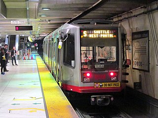
<span class="mw-page-title-main">Powell Street station</span> Rapid transit station in San Francisco, California, US

Powell Street station is a combined BART and Muni Metro rapid transit station in the Market Street subway in downtown San Francisco. Located under Market Street between 4th Street and 5th Street, it serves the Financial District neighborhood and surrounding areas. The three-level station has a large fare mezzanine level, with separate platform levels for Muni Metro and BART below. The station is served by the BART Red, Yellow, Green, and Blue lines, and the Muni Metro J Church, K Ingleside, L Taraval, M Ocean View, N Judah, and S Shuttle lines.

<span class="mw-page-title-main">Castro station</span> Muni Metro station in the Castro district of San Francisco, California

Castro station is a Muni Metro station at the intersection of Market Street, Castro Street, and 17th Street in the Castro District of San Francisco, California. The underground station is served by the K Ingleside, M Ocean View, and S Shuttle lines. The F Market line serves the station on the street level at 17th and Castro.

<span class="mw-page-title-main">West Portal station</span> Light rail stop in San Francisco

West Portal station is a Muni Metro station in the West Portal neighborhood in San Francisco, California. It is built around the western entrance to the Twin Peaks Tunnel. The station consists of two side platforms, with the entrance at the western end. A non-accessible footbridge connects the platforms inside fare control.

<span class="mw-page-title-main">Twin Peaks Tunnel</span> Light rail tunnel in San Francisco, California

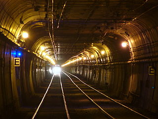
The Twin Peaks Tunnel is a 2.27-mile-long (3.65 km) light rail/streetcar tunnel in San Francisco, California. The tunnel runs under Twin Peaks and is used by the K Ingleside, M Ocean View and S Shuttle lines of the Muni Metro system.

<span class="mw-page-title-main">Market Street subway</span> BART-Muni Metro main line, San Francisco

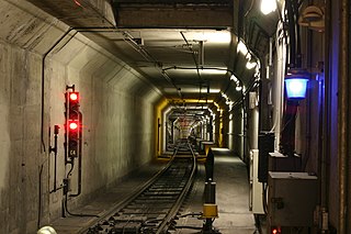
The Market Street subway is a two-level subway tunnel that carries Muni Metro and BART trains under Market Street in San Francisco, California. It runs under the length of Market Street between Embarcadero station and Castro station. The upper level is used by Muni Metro lines and the lower level is used by BART lines. BART does not run through the whole subway; it turns south and runs under Mission Street southwest of Civic Center/UN Plaza station. The northeastern end of the BART level is connected to the Transbay Tube. On the Muni Metro level, the southwestern end of the Market Street subway connects to the much-older Twin Peaks Tunnel, and the northeastern end connects to surface tracks along the Embarcadero.

<span class="mw-page-title-main">Eureka Valley station</span> Abandoned streetcar station in San Francisco, California

Eureka Valley station is an abandoned underground streetcar station in San Francisco, California. It was located inside the Twin Peaks Tunnel, very close to its eastern end in the Eureka Valley neighborhood. The station opened in 1918, and was closed in 1972 during the construction of the Market Street subway.

<span class="mw-page-title-main">Balboa Park station</span> Transit station in San Francisco, California, US

Balboa Park station is a Bay Area Rapid Transit (BART) station and Muni Metro complex in the Mission Terrace neighborhood of San Francisco, California, located near the eponymous Balboa Park. It is an intermodal hub served by four BART routes, three Muni Metro lines, and a number of Muni bus routes. The station complex also includes two rail yards, Cameron Beach Yard and Green Light Rail Center, where Muni maintains Muni Metro trains and heritage streetcars. BART uses a below-grade island platform on the west side of the complex; Muni Metro routes use several smaller side platforms located on surface-level rail loops around the yards.
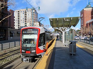
<span class="mw-page-title-main">San Francisco State University station</span>

San Francisco State University station is a light rail station on the Muni Metro M Ocean View line, located adjacent to San Francisco State University and the Parkmerced neighborhood in the median of 19th Avenue in San Francisco, California. It opened in 1925 with the first phase of the line and was rebuilt with a high-level island platform in 1993. The station is accessible.

<span class="mw-page-title-main">The Embarcadero and Brannan station</span>

Brannan and The Embarcadero station is a Muni Metro light rail station located in the median of The Embarcadero south of Brannan Street in the South Beach area of San Francisco, California. Muni Metro trains use a high-level island platform, while historic streetcars use a pair of side platforms at the south end of the station.

<span class="mw-page-title-main">Duboce and Church station</span>

Duboce and Church is a light rail stop on the Muni Metro J Church and N Judah lines, located in the Duboce Triangle neighborhood of San Francisco, California. Just east of the station, the two lines enter the Market Street subway. The stop originally opened with the 22 Fillmore line in 1895. The station has complex layout with two side platforms in the middle of Duboce Avenue for the N Judah, one side platform in the middle of Church Street for northbound J Church trains entering the Market Street subway, and two mini-high platforms at the subway portal which provides access to both lines for people with disabilities.

<span class="mw-page-title-main">Church and 18th Street station</span>

Church and 18th Street station is a light rail stop on the Muni Metro J Church line, located in the northwest corner of Dolores Park in San Francisco, California. The stop opened with the line on August 11, 1917. The eastbound (inbound) platform is located inside Dolores Park on Muni's right of way; the westbound (outbound) platform is a traffic island on Church Street. Mini-high platforms providing access to people with disabilities are located inside the park next to 18th Street.

<span class="mw-page-title-main">Church and 24th Street station</span>

Church and 24th Street is a light rail stop on the Muni Metro J Church line, located in the Noe Valley neighborhood of San Francisco, California. The stop opened with the line on August 11, 1917. The station has two side platforms in the middle of Church Street where passengers board or depart from trains. The station also has mini-high platforms providing access to people with disabilities.

<span class="mw-page-title-main">Church and 30th Street station</span>

Church and 30th Street station is a one-way light rail stop on the Muni Metro J Church line, located in the Noe Valley neighborhood of San Francisco, California. The stop is only served by inbound trains; outbound trains stop further north at Day Street. The stop has no platforms, trains stop at marked poles and passengers cross a vehicle travel lanes to board trains. The stop is not accessible to people with disabilities.

<span class="mw-page-title-main">15th Avenue and Taraval station</span>

15th Avenue and Taraval station is a westbound-only light rail stop on the Muni Metro L Taraval line, located in the Parkside neighborhood of San Francisco, California. The station opened with the first section of the L Taraval line on April 12, 1919. Eastbound trains stop at the nearby Taraval and 17th Avenue station.

References

  1. Cerny, Susan Dinkelspiel (2007). An Architectural Guidebook to San Francisco and the Bay Area (1st ed.). Layton, UT: Gibbs Smith. pp. 501–502. ISBN   978-1-58685-432-4. OCLC   85623396.
  2. Callwell, Robert (September 1999). "Transit in San Francisco: A Selected Chronology, 1850–1995" (PDF). San Francisco Municipal Railway. p. 58.
  3. "Conditional Use Authorization" (PDF). San Francisco Planning Department. January 9, 2020.
  4. Page & Turnbull (March 2007). "Primary Record" (PDF). California Department of Parks and Recreation.
  5. "Names Approved for 38 Rapid Transit Stations Around Bay". Oakland Tribune. December 10, 1965. p. 10 via Newspapers.com.
  6. Mendoza, Joe (2010). Muni Metro: Bay Area Transit Album Vol. 2: San Francisco's Light Rail Lines + Streetcar & Cable Car lines. San Francisco CA: Metro City Books. p. 22. ISBN   9781453640869.
  7. 1 2 "J Church Transfer Improvements". San Francisco Municipal Transportation Agency. 26 June 2020.
  8. Graf, Carly (August 18, 2020). "Muni 'improvements' could make things harder for seniors, accessible". San Francisco Examiner.
  9. "Bus Substitution for All Rail Lines" (Press release). San Francisco Municipal Transportation Agency. August 25, 2020.
  10. Maguire, Mariana (December 7, 2020). "Upcoming Muni Service Expansions Phase-in Rail Service, Add Bus Service" (Press release). San Francisco Municipal Transportation Agency.
  11. "This Route is Shortened". San Francisco Municipal Transportation Agency. December 19, 2020. Archived from the original on December 20, 2020.
  12. Streeter, Jonathan (March 2, 2021). "Temporary Ramps Provide a Platform for Local Artists" (Press release). San Francisco Municipal Transportation Agency.
  13. "Upper Market Safety Project: Summer 2021 Construction Update" (PDF). San Francisco Municipal Transportation Agency. June 2021.
  14. "Streetscape Plan" (PDF). San Francisco Municipal Transportation Agency. June 2021.
  15. Bajko, Matthew S. (October 19, 2022). "SF project adds Milk nod to Castro arterial". The Bay Area Reporter. Retrieved October 24, 2022.

Commons-logo.svg Media related to Church station (Muni Metro) at Wikimedia Commons