Union City station

Last updated

Union City
Union City station platforms, July 2017.JPG
Union City station platforms in 2017
General information
Location10 Union Square
Union City, California
Coordinates 37°35′27″N122°01′02″W / 37.590746°N 122.017282°W / 37.590746; -122.017282
Line(s) BART A-Line
Platforms2 side platforms
Connections
Construction
Structure typeElevated
Parking1,197 spaces [1]
Bicycle facilities20 BikeLink lockers
AccessibleYes
ArchitectKitchen & Hunt [2]
History
OpenedSeptember 11, 1972
RebuiltFebruary 12, 2014
Passengers
20241,767 (weekday average) [3]
Services
Preceding station Bart compact logo.svg Bay Area Rapid Transit Following station
South Hayward
toward Daly City
Green Line Fremont
South Hayward
toward Richmond
Orange Line
Proposed services (2030)
Preceding station Altamont Corridor Express Following station
Terminus Union City – Merced Pleasanton
toward Merced
Location
Union City station

Union City station is a Bay Area Rapid Transit (BART) station in Union City, California. The station sits near Decoto Road east of Alvarado-Niles Road, directly behind the James Logan High School campus. The station is served by the Orange and Green lines. Local bus service is provided by Union City Transit and AC Transit.

Contents

History

Main entrance and bus bays in 2013 Union City BART Station.jpg
Main entrance and bus bays in 2013

The BART Board approved the name "Union City" in December 1965. [4] Service at the station began on September 11, 1972. [5] Due to a national strike that year by elevator constructors, elevator construction on the early stations was delayed. Elevators at most of the initial stations, including Union City, were completed in the months following the opening. [6] [7] The fare lobby features tile mosaics designed by Jean Varda and constructed by Alfonso Pardiñas. [8] The station was not originally served by buses. [9] "The Flea" (now Union City Transit) began operating in Union City in 1974. [10] AC Transit service was expanded to Fremont in November 1974, and to Newark that December, with some routes serving Union City station. [11] [12] AC Transit began operating service between Union City station and Palo Alto station over the Dumbarton Bridge – later branded Dumbarton Express – on September 10, 1984. [13] [14]

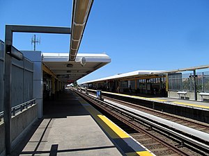
As built, the station only had access from Union Way. In 2008, construction started on a reconfiguration of the parking lots, which included a new station roadway connecting to Decoto Road. The work was intended to improve access to the station, particularly from new development on the east side of the tracks. [15] A commuter rail platform for existing Capitol Corridor service and the proposed Dumbarton Rail Corridor was also proposed in 2008. [16] [17] [18] (Later plans have called for the Capitol Corridor to be rerouted over the Coast Line to the west, which would not permit a Union City stop). [19] The parking lot and roadway work was completed in March 2012, with buses using new stops adjacent to the station entrance. [20]

The next round of changes to the station were made in anticipation of a future entrance on the east side of the station. [21] A expanded ground-level fare lobby with provisions for future pedestrian pass-through outside the paid area was completed in 2017. [22] That year, the California Public Utilities Commission approved plans for an at-grade pedestrian crossing of the Union Pacific Railroad Oakland Subdivision in lieu of a more expensive grade-separated crossing. [23] Construction work on Phase 2A, which added two new escalators to the east (northbound) BART platform, took place from 2019 to December 2022. [24] [25] [23] As of October 2023, construction on the pedestrian crossing is expected to be complete by 2025. [23]

Some Altamont Corridor Express (ACE) services are planned to be expanded to Union City, with a new platform on the Oakland Subdivision adjacent to the BART station. [26] [27] Three daily ACE round-trips are proposed to serve the station by 2030: two Union City–Merced round trips and one Union City–Natomas round trip. [27] [28] [26]

Related Research Articles

<span class="mw-page-title-main">Bay Area Rapid Transit</span> Rapid transit system serving the San Francisco Bay Area

Bay Area Rapid Transit (BART) is a rapid transit system serving the San Francisco Bay Area in California. BART serves 50 stations along six routes and 131 miles of track, including a 9-mile (14 km) spur line running to Antioch, which uses diesel multiple unit vehicles, and a 3-mile (4.8 km) automated guideway transit line serving Oakland International Airport. With an average of 160,400 weekday passengers as of the fourth quarter of 2023 and 48,119,400 annual passengers in 2023, BART is the seventh-busiest rapid transit system in the United States.

<span class="mw-page-title-main">AC Transit</span> Public transit operator in Alameda County and Contra Costa County, California

AC Transit is an Oakland-based public transit agency serving the western portions of Alameda and Contra Costa counties in the East Bay of the San Francisco Bay Area. AC Transit also operates "Transbay" routes across San Francisco Bay to San Francisco and selected areas in San Mateo and Santa Clara counties. AC Transit is constituted as a special district under California law. It is governed by seven elected members. It is not a part of or under the control of Alameda or Contra Costa counties or any local jurisdictions.

<span class="mw-page-title-main">Embarcadero station</span> Subway station in San Francisco, California, US

Embarcadero station is a combined BART and Muni Metro rapid transit subway station in the Market Street subway in downtown San Francisco. Located under Market Street between Drumm Street and Beale Street near The Embarcadero, it serves the Financial District neighborhood and surrounding areas. The three-level station has a large fare mezzanine level, with separate platform levels for Muni Metro and BART below. Embarcadero station opened in May 1976 – almost two years after service began through the Transbay Tube – as an infill station.

<span class="mw-page-title-main">Civic Center/UN Plaza station</span> Rapid transit station in San Francisco, California, US

Civic Center/UN Plaza station is a combined BART and Muni Metro rapid transit station in the Market Street subway in downtown San Francisco. Located under Market Street between 7th Street and 8th Street, it is named for the Civic Center neighborhood and the adjacent United Nations Plaza. The three-level station has a large fare mezzanine level, with separate platform levels for Muni Metro and BART below.

<span class="mw-page-title-main">West Oakland station</span> Rapid transit station in San Francisco Bay Area

West Oakland station is a Bay Area Rapid Transit (BART) station in the West Oakland neighborhood of Oakland, California. It has two elevated side platforms and is located near the eastern end of the Transbay Tube. All main BART lines except the Orange Line stop at the station. The Oakland Wye is located to the east of the station.

<span class="mw-page-title-main">12th Street Oakland City Center station</span> Rapid transit station in Oakland, California, US

12th Street/Oakland City Center station is an underground Bay Area Rapid Transit (BART) station located under Broadway between 12th Street and 14th Street in Downtown Oakland, adjacent to the Oakland City Center. The station has three underground levels, with tracks on the second and third levels. It is served by the Red Line, Orange Line, and Yellow Line, as well as by AC Transit buses on the surface.

<span class="mw-page-title-main">19th Street Oakland station</span> Metro station in Oakland, California, US

19th Street Oakland station is an underground Bay Area Rapid Transit (BART) station located under Broadway between 17th Street and 20th Street in the Uptown District of Oakland, California. It is a timed transfer point between northbound trains to Richmond and to Antioch. The station has three underground levels, with tracks on the second and third levels. It is served by the Red Line, Orange Line, and Yellow Line, as well as by AC Transit buses on the surface at the Uptown Transit Center.

<span class="mw-page-title-main">Fruitvale station</span> Rapid transit station in San Francisco Bay Area

Fruitvale station is a Bay Area Rapid Transit (BART) station located in the Fruitvale District of Oakland, California. The elevated station has two side platforms. The station is served by the Orange, Green, and Blue lines.

<span class="mw-page-title-main">Richmond station (California)</span> Railway station in Richmond, California, US

Richmond station is an Amtrak intercity rail and Bay Area Rapid Transit (BART) station located in downtown Richmond, California. Richmond is the north terminus of BART service on the Orange Line and Red Line; it is a stop for Amtrak's Capitol Corridor, San Joaquins, and California Zephyr routes. The accessible station has one island platform for the two BART tracks, with a second island platform serving two of the three tracks of the Union Pacific Railroad Martinez Subdivision for Amtrak trains. It is one of two transfer points between BART and Amtrak, along with Oakland Coliseum station.

<span class="mw-page-title-main">San Leandro station</span> Rapid transit station in San Francisco Bay Area

San Leandro station is a Bay Area Rapid Transit (BART) station located off Davis Street in downtown San Leandro, California. The station has two elevated side platforms, with the faregates at ground level. The station is served by the Orange, Green, and Blue lines.

<span class="mw-page-title-main">Bay Fair station</span> Rapid transit station in San Francisco Bay Area

Bay Fair station is a Bay Area Rapid Transit (BART) station located adjacent to the Bayfair Center mall in San Leandro, California. The station is served by the Orange, Green, and Blue lines.

<span class="mw-page-title-main">Fremont station (BART)</span> Bay Area Rapid Transit (BART) station in San Francisco Bay Area

Fremont station is a Bay Area Rapid Transit (BART) station in the central district of Fremont, California. The station is served by the Orange and Green lines. It was the southern terminus of both lines from September 11, 1972, until March 25, 2017, when Warm Springs/South Fremont station opened.

<span class="mw-page-title-main">MacArthur station (BART)</span> Rapid transit station in San Francisco Bay Area

MacArthur station is a Bay Area Rapid Transit (BART) station in the Temescal District of Oakland, California. It is the largest station in the BART system, being the only one with four platform tracks. Service through MacArthur is timed for cross-platform transfers between the southbound lines that pass through the station. MacArthur station is located in the median of SR 24 just north of its interchange with I-580. The station is perpendicular to 40th Street and MacArthur Boulevard. The surrounding neighborhood is mostly low-density residential, making MacArthur station primarily a commuting hub.

<span class="mw-page-title-main">Hayward station (BART)</span> Metro station in Hayward, California, US

Hayward station is a Bay Area Rapid Transit (BART) station in Hayward, California, serving Downtown Hayward and the surrounding areas. It is served by the Orange and Green lines. The elevated station has two side platforms. A two-lane bus terminal is located on the northeast side of the station. A pedestrian tunnel under the Union Pacific Railroad Oakland Subdivision connects the fare lobby to a parking lot and a five-level parking garage.

<span class="mw-page-title-main">Dumbarton Express</span> Bus service in the San Francisco Bay Area

Dumbarton Express is a regional public transit service in the San Francisco Bay Area connecting Alameda, San Mateo, and Santa Clara Counties via the Dumbarton Bridge, the system's namesake. The bus service is funded by a consortium of five transit agencies. Dumbarton Express is administered by AC Transit and operated under contract by MV Transportation.

<span class="mw-page-title-main">Emeryville station</span> Amtrak station in Emeryville, California, United States

Emeryville station is an Amtrak station in Emeryville, California, United States. The station is served by the California Zephyr, Capitol Corridor, Coast Starlight, and San Joaquins. The station is the primary connection point for Amtrak Thruway buses serving San Francisco.

<span class="mw-page-title-main">Oakland Coliseum station</span> Rail station in Oakland, California, US

The station complex of Amtrak's Oakland Coliseum station and Bay Area Rapid Transit (BART)'s Coliseum station is located in the East Oakland area of Oakland, California, United States. The two stations, located about 600 feet (180 m) apart, are connected to each other and to the Oakland Coliseum/Oakland Arena sports complex with an accessible pedestrian bridge. The BART station is served by the Orange, Green, and Blue lines; the Amtrak station is served by the Capitol Corridor service.

Throughout the history of Bay Area Rapid Transit, there have been plans to extend service to other areas.

<span class="mw-page-title-main">Milpitas station</span> Transit center served by BART trains, VTA light rail and buses

Milpitas station, also known as Milpitas Transit Center, is an intermodal transit station located near the intersection of East Capitol Avenue and Montague Expressway in Milpitas, California. The station is served by the Orange Line and Green Line Bay Area Rapid Transit (BART) lines, the Orange Line of the VTA light rail system, VTA buses, and AC Transit buses.

<span class="mw-page-title-main">Dumbarton Rail Corridor</span> Passenger Rail Line

The Dumbarton Rail Corridor is a proposed transbay passenger rail line which would reuse the right-of-way that was initially constructed from 1907–1910 as the Dumbarton Cut-off. The Dumbarton Cut-off includes the first structure to span San Francisco Bay, the 1910 Dumbarton Rail Bridge, although the vintage Cut-off bridges would likely be replaced prior to activating new passenger service. Dumbarton Rail Corridor would provide service between Union City in the East Bay and Menlo Park on the Peninsula, with train service continuing to both San Francisco and San José along the existing Caltrain tracks. It has been in the planning stages since 1988, and would be the first above-ground transbay rail line since Key System electric trains stopped running on the lower deck of the Bay Bridge in 1958, and the first new transbay crossing of any kind since the completion of the Transbay Tube in 1974.

References

  1. "Union City Station". Bay Area Rapid Transit (BART). Retrieved December 4, 2013.
  2. Cerny, Susan Dinkelspiel (2007). An Architectural Guidebook to San Francisco and the Bay Area (1st ed.). Layton, UT: Gibbs Smith. pp. 501–502. ISBN   978-1-58685-432-4. OCLC   85623396.
  3. "Monthly Ridership Reports". San Francisco Bay Area Rapid Transit District. February 2024.
  4. "Names Approved for 38 Rapid Transit Stations Around Bay". Oakland Tribune. December 10, 1965. p. 10 via Newspapers.com.
  5. "BART Chronology January 1947 – March 2009" (PDF). San Francisco Bay Area Rapid Transit District. March 2009. Archived from the original (PDF) on October 13, 2013.
  6. "Strike Delays Elevator Service at Some Stations". Oakland Tribune. September 10, 1972. p. 36 via Newspapers.com.
  7. "Four BART Lines Make The System". The Independent. February 26, 1973. p. 30 via Newspapers.com.
  8. Weinstein, Dave. "How BART got ART". CA-Modern. Eichler Network. p. 6.
  9. Kusserow, H.W. (September 15, 1972). "BART Banks First Fares". The San Francisco Examiner. p. 5 via Newspapers.com.
  10. Abbott, Jane; Holzmeister, Karen (October 17, 1974). "The Union City Flea flits about the town". The Argus. p. 2 via Newspapers.com.
  11. History of Lines by Line: Major Changes Since 1960 (PDF). Alameda-Contra Costa Transit District). July 17, 1978. pp. 74–77.
  12. "8,000 riders flock to use Fremont's bus system". The Argus. November 20, 1974. p. 9 via Newspapers.com.
  13. "Authorize the Interim General Manager to Enter Into a Further Nine Month Extension of the Dumbarton Bridge Express Service Cooperative Agreement to June 30, 2011" (PDF). Alameda-Contra Costa Transit District. September 10, 2010.
  14. Taylor, Steve (September 5, 1984). "Buses to cross bridge". The Peninsula Times Tribune. pp. B-1, B-3 via Newspapers.com.
  15. "Union City Station construction to relocate parking and bus stops" (Press release). San Francisco Bay Area Rapid Transit District. April 18, 2008.
  16. "Intermodal Station District". City of Union City, California. Archived from the original on August 27, 2008. Retrieved June 7, 2008.
  17. "BART builds solar-powered rail station". Trains Magazine. 68 (2): 23. February 2008. ISSN   0041-0934.
  18. "Summary of the Dumbarton Rail Corridor Project Study Report" (PDF). San Mateo County Transit Authority. May 2004. pp. 3, 18. Archived (PDF) from the original on March 18, 2016. Retrieved March 18, 2016.
  19. "Capitol Corridor Intercity Passenger Rail Service Business Plan Update FY 2020–21 – 2021–22" (PDF). Capitol Corridor Joint Powers Authority. Retrieved June 8, 2020.
  20. "Union City Station intermodal area fully open" (Press release). San Francisco Bay Area Rapid Transit District. March 5, 2012.
  21. "Annual Program Compliance Report: Reporting Fiscal Year 2018-2019" (PDF). City of Union City. July 30, 2020.
  22. "Union City Station transit-oriented development project hits a milestone" (Press release). San Francisco Bay Area Rapid Transit District. May 9, 2017.
  23. 1 2 3 Azim, Farooq (October 18, 2023). "At-Grade Pedestrian Crossing at BART Station & Closure of "I" Street at 12th Street Presentation". City of Union City.
  24. "BART Safety, Reliability, and Traffic Relief Program (Measure RR) Update" (PDF). San Francisco Bay Area Rapid Transit District. December 20, 2019. p. 18.
  25. "BART Safety, Reliability, and Traffic Relief Program (Measure RR) Update" (PDF). San Francisco Bay Area Rapid Transit District. December 18, 2020. pp. 13–24.
  26. 1 2 "Union City on track to become regional transit hub by 2030". East Bay Echo. December 12, 2023. Retrieved December 22, 2023.
  27. 1 2 "Union City ACE/BART Rail-to-Rail Hub Station: Project Overview and Update". San Joaquin Regional Rail Commission. June 2022.
  28. Krause, Daniel; Mangonon, Anthony (June 1, 2022). Deliverable 3.1.3 (Initial Service and Operations Planning Analysis) (PDF). Wordpress (Report). AECOM. Retrieved December 21, 2023.

Commons-logo.svg Media related to Union City station at Wikimedia Commons