Fremont is a city in Alameda County, California, United States. Located in the East Bay region of the Bay Area, Fremont has a population of 230,504 as of 2020, making it the fourth most populous city in the Bay Area, behind San Jose, San Francisco, and Oakland. It is the closest East Bay city to the high-tech Silicon Valley network of businesses, and has a strong tech industry presence.

Bay Area Rapid Transit (BART) is a rapid transit system serving the San Francisco Bay Area in California. BART serves 50 stations along six routes and 131 miles of track, including eBART, a 9-mile (14 km) spur line running to Antioch, and Oakland Airport Connector, a 3-mile (4.8 km) automated guideway transit line serving San Francisco Bay Oakland International Airport. With an average of 165,400 weekday passenger trips as of the second quarter of 2024 and 48,119,400 annual passenger trips in 2023, BART is the sixth-busiest rapid transit system in the United States.

AC Transit is an Oakland-based public transit agency serving the western portions of Alameda and Contra Costa counties in the East Bay of the San Francisco Bay Area. AC Transit also operates "Transbay" routes across San Francisco Bay to San Francisco and selected areas in San Mateo and Santa Clara counties. AC Transit is constituted as a special district under California law. It is governed by seven elected members. It is not a part of or under the control of Alameda or Contra Costa counties or any local jurisdictions.

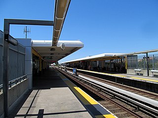
Fremont station is a Bay Area Rapid Transit (BART) station in the central district of Fremont, California. The station is served by the Orange and Green lines. It was the southern terminus of both lines from September 11, 1972, until March 25, 2017, when Warm Springs/South Fremont station opened.

Union City station is a Bay Area Rapid Transit (BART) station in Union City, California. The station sits near Decoto Road east of Alvarado-Niles Road, directly behind the James Logan High School campus. The station is served by the Orange and Green lines. Local bus service is provided by Union City Transit and AC Transit.

The station complex of Amtrak's Oakland Coliseum station and Bay Area Rapid Transit (BART)'s Coliseum station is located in the East Oakland area of Oakland, California, United States. The two stations, located about 600 feet (180 m) apart, are connected to each other and to the Oakland Coliseum/Oakland Arena sports complex with an accessible pedestrian bridge. The BART station is served by the Orange, Green, and Blue lines; the Amtrak station is served by the Capitol Corridor service.

Fremont Central Park is a 450-acre (180 ha) manmade park in the central area of Fremont, California on Paseo Padre Parkway at Stevenson Boulevard. It is accessible from I-880 and I-680. It began development in 1960, and contains Lake Elizabeth, a shallow 83-acre (34 ha) man made lake surrounded by picnic areas, sports fields, and walking and biking paths. The lake was dedicated to Fremont's sister city, Elizabeth, South Australia in 1969. A nine-hole golf course and driving range is northeast of the park, while a skateboarding park and water slide swimming facility are southwest. The ecosystem and area around the park promotes diverse flora and fauna. Fremont Central Park is traversable on foot, and can be accessed by public roads. Much of the park was once the Stivers Lagoon and is part of the Laguna Creek Watershed.
Throughout the history of Bay Area Rapid Transit, there have been plans to extend service to other areas.
Bay Area Rapid Transit, widely known by the acronym BART, is the main rail transportation system for the San Francisco Bay Area. It was envisioned as early as 1946 but the construction of the original system began in the 1960s.

Bike East Bay, formerly known as East Bay Bicycle Coalition, is a Californian non-profit organization that worked since 1972 toward "promoting bicycling as an everyday means of transportation and recreation" in Alameda and Contra Costa counties of the California's East Bay.

The Salesforce Transit Center, also known as the Transbay Transit Center, is a transit center in downtown San Francisco. It serves as the primary bus terminal for the San Francisco Bay Area, and is proposed as a possible future rail terminal. The centerpiece of the San Francisco Transbay development, the construction is governed by the Transbay Joint Powers Authority (TJPA). The 1,430-foot-long (440 m) building sits one block south-east of Market Street, a primary commercial and transportation artery.
Measure R was a ballot measure during the November 2008 elections in Los Angeles County, California, that proposed a half-cent sales taxes increase on each dollar of taxable sales for thirty years in order to pay for transportation projects and improvements. The measure was approved by voters with 67.22% of the vote, just over the two-thirds majority required by the state of California to raise local taxes. The project was touted as a way to "improve the environment by getting more Angelenos out of their cars and into the region's growing subway, light rail, and bus services." It will result in the construction or expansion of a dozen rail lines in the county.

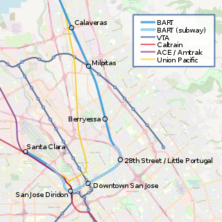
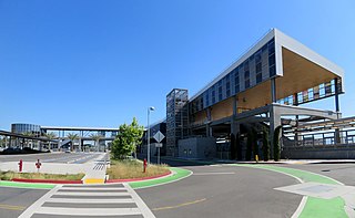
Berryessa/North San José station is an intermodal transit center located in the Berryessa district of San Jose, California, United States. The station is served by Bay Area Rapid Transit (BART) and Santa Clara Valley Transportation Authority (VTA) buses. The transit center opened for bus service on December 28, 2019, and subsequently for BART service on June 13, 2020. The station is the southern terminus of the Orange and Green lines.

28th Street/Little Portugal station is a proposed underground Bay Area Rapid Transit station in the Little Portugal neighborhood of San Jose, California. It would be located north of East Santa Clara Street between North 28th Street and U.S. Route 101, behind Five Wounds Portuguese National Church. Preceded by Berryessa/North San José station, it would be the first station of the Phase II portion of the Silicon Valley BART extension. The station would have direct service to Santa Clara, Richmond, and San Francisco/Daly City.
The Silicon Valley BART extension is an ongoing effort to expand the Green and Orange Line service by Bay Area Rapid Transit (BART) into Santa Clara County via the East Bay from its former terminus at the Fremont station in Alameda County. Planned since at least 1981, the project has seven stations in three sequential phases.

Warm Springs/South Fremont station is a Bay Area Rapid Transit (BART) station located in the Warm Springs district of Fremont, California. The station is served by the Orange and Green lines. It was the southern terminus of both lines from its opening on March 25, 2017 until June 13, 2020, when Milpitas and Berryessa/North San José stations opened as part of the Silicon Valley BART extension.

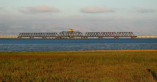
The Dumbarton Rail Bridge lies just to the south of the Dumbarton road bridge. Built in 1910, the rail bridge was the first structure to span San Francisco Bay, shortening the rail route between Oakland and San Francisco by 26 miles (42 km). The last freight train traveled over the bridge in 1982, and it has been proposed since 1991 to reactivate passenger train service to relieve traffic on the road bridges, though this would entail a complete replacement of the existing bridge. Part of the western timber trestle approach collapsed in a suspected arson fire in 1998.

The Dumbarton Rail Corridor is a proposed transbay passenger rail line which would reuse the right-of-way that was initially constructed from 1907–1910 as the Dumbarton Cut-off. The Dumbarton Cut-off includes the first structure to span San Francisco Bay, the 1910 Dumbarton Rail Bridge, although the vintage Cut-off bridges would likely be replaced prior to activating new passenger service. Dumbarton Rail Corridor would provide service between Union City in the East Bay and Menlo Park on the Peninsula, with train service continuing to both San Francisco and San José along the existing Caltrain tracks. It has been in the planning stages since 1988, and would be the first above-ground transbay rail line since Key System electric trains stopped running on the lower deck of the Bay Bridge in 1958, and the first new transbay crossing of any kind since the completion of the Transbay Tube in 1974.

Grace Crunican is a mass transportation specialist who most recently served as general manager of the San Francisco Bay Area Rapid Transit (BART) District. She had previously worked for the Oregon Department of Transportation, the Federal Transit Administration, and the Seattle Department of Transportation, and also at the mass transit lobbying organization called the Surface Transportation Policy Project.


