
AC Transit is an Oakland-based public transit agency serving the western portions of Alameda and Contra Costa counties in the East Bay of the San Francisco Bay Area. AC Transit also operates "Transbay" routes across San Francisco Bay to San Francisco and selected areas in San Mateo and Santa Clara counties. AC Transit is constituted as a special district under California law. It is governed by seven elected members. It is not a part of or under the control of Alameda or Contra Costa counties or any local jurisdictions.

The Key System was a privately owned company that provided mass transit in the cities of Oakland, Berkeley, Alameda, Emeryville, Piedmont, San Leandro, Richmond, Albany, and El Cerrito in the eastern San Francisco Bay Area from 1903 until 1960, when it was sold to a newly formed public agency, AC Transit. The Key System consisted of local streetcar and bus lines in the East Bay, and commuter rail and bus lines connecting the East Bay to San Francisco by a ferry pier on San Francisco Bay, later via the lower deck of the Bay Bridge. At its height during the 1940s, the Key System had over 66 miles (106 km) of track. The local streetcars were discontinued in 1948 and the commuter trains to San Francisco were discontinued in 1958. The Key System's territory is today served by BART and AC Transit bus service.
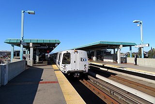
Daly City station is an elevated Bay Area Rapid Transit (BART) station in Daly City, California, just south of the city limits of San Francisco. It is adjacent to Interstate 280 and California Route 1, which it serves as a park-and-ride station. The station is served by the Red, Yellow, Green, and Blue lines; it is the western terminus of the Green and Blue lines.
West Oakland station is a Bay Area Rapid Transit (BART) station in the West Oakland neighborhood of Oakland, California. It has two elevated side platforms and is located near the eastern end of the Transbay Tube. All main BART lines except the Orange Line stop at the station. The Oakland Wye is located to the east of the station.
12th Street/Oakland City Center station is an underground Bay Area Rapid Transit (BART) station located under Broadway between 12th Street and 14th Street in Downtown Oakland, adjacent to the Oakland City Center. The station has three underground levels, with tracks on the second and third levels. It is served by the Red Line, Orange Line, and Yellow Line, as well as by AC Transit buses on the surface.

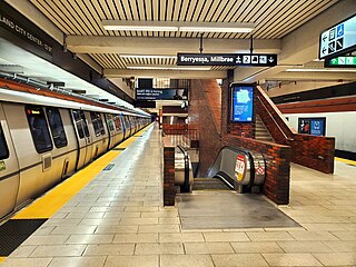
19th Street Oakland station is an underground Bay Area Rapid Transit (BART) station located under Broadway between 17th Street and 20th Street in the Uptown District of Oakland, California. It is a timed transfer point between northbound trains to Richmond and to Antioch. The station has three underground levels, with tracks on the second and third levels. It is served by the Red Line, Orange Line, and Yellow Line, as well as by AC Transit buses on the surface at the Uptown Transit Center.
Fruitvale station is a Bay Area Rapid Transit (BART) station located in the Fruitvale District of Oakland, California. The elevated station has two side platforms. The station is served by the Orange, Green, and Blue lines.
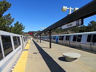
Orinda station is a Bay Area Rapid Transit station in Orinda, California. The station has an island platform in the center median of State Route 24. It is served by the Yellow Line. An abstract mural by Win Ng, partially covered by advertisements, is located in the fare lobby.

Concord station is a Bay Area Rapid Transit (BART) station in Concord, California. The station is located between the downtown business district to the west and residential neighborhoods to the east. Concord station has a single elevated island platform and is served by the Yellow Line.

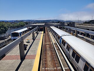
Richmond station is an Amtrak intercity rail and Bay Area Rapid Transit (BART) station located in downtown Richmond, California. Richmond is the north terminus of BART service on the Orange Line and Red Line; it is a stop for Amtrak's Capitol Corridor, San Joaquins, and California Zephyr routes. The accessible station has one island platform for the two BART tracks, with a second island platform serving two of the three tracks of the Union Pacific Railroad Martinez Subdivision for Amtrak trains. It is one of two transfer points between BART and Amtrak, along with Oakland Coliseum station.

San Leandro station is a Bay Area Rapid Transit (BART) station located off Davis Street in downtown San Leandro, California. The station has two elevated side platforms, with the faregates at ground level. The station is served by the Orange, Green, and Blue lines.

Bay Fair station is a Bay Area Rapid Transit (BART) station located adjacent to the Bayfair Center mall in San Leandro, California. The station is served by the Orange, Green, and Blue lines.

Fremont station is a Bay Area Rapid Transit (BART) station in the central district of Fremont, California. The station is served by the Orange and Green lines. It was the southern terminus of both lines from September 11, 1972, until March 25, 2017, when Warm Springs/South Fremont station opened.

MacArthur station is a Bay Area Rapid Transit (BART) station in the Temescal District of Oakland, California. It is the largest station in the BART system, being the only one with four platform tracks. Service through MacArthur is timed for cross-platform transfers between the southbound lines that pass through the station. MacArthur station is located in the median of SR 24 just north of its interchange with I-580. The station is perpendicular to 40th Street and MacArthur Boulevard. The surrounding neighborhood is mostly low-density residential, making MacArthur station primarily a commuting hub.

Downtown Berkeley station is an underground Bay Area Rapid Transit (BART) station in the Downtown Berkeley section of Berkeley, California. It is served by the Orange and Red lines.
Union City station is a Bay Area Rapid Transit (BART) station in Union City, California. The station sits near Decoto Road east of Alvarado-Niles Road, directly behind the James Logan High School campus. The station is served by the Orange and Green lines. Local bus service is provided by Union City Transit and AC Transit.

South Hayward station is a Bay Area Rapid Transit (BART) station located off the Tennyson Road arterial in Hayward, California. It is served by the Orange and Green lines.

Emeryville station is an Amtrak station in Emeryville, California, United States. The station is served by the California Zephyr, Capitol Corridor, Coast Starlight, and San Joaquins. The station is the primary connection point for Amtrak Thruway buses serving San Francisco.

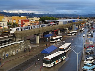
The station complex of Amtrak's Oakland Coliseum station and Bay Area Rapid Transit (BART)'s Coliseum station is located in the East Oakland area of Oakland, California, United States. The two stations, located about 600 feet (180 m) apart, are connected to each other and to the Oakland Coliseum/Oakland Arena sports complex with an accessible pedestrian bridge. The BART station is served by the Orange, Green, and Blue lines; the Amtrak station is served by the Capitol Corridor service.

The Zephyrette was a tri-weekly train consisting of a Budd Rail Diesel Car (RDC) run by the Western Pacific Railroad between Oakland, California, and Salt Lake City from 1950 to 1960. Covering 924 miles (1,487 km), it was the longest RDC service in the United States. The successor to the Western Pacific's Royal Gorge as a secondary supplement to the California Zephyr, the Zephyrette began service on September 15, 1950. Both the existence and western terminus of the route were shaped by the stipulations of regulatory agencies, while the two RDCs the railroad purchased for the train were substantially modified before entering revenue service.


