Orinda station

Last updated
Orinda
Old and new BART trains at Orinda station, March 2018.JPG
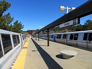
Two trains at Orinda station in March 2018
General information
Location11 Camino Pablo
Orinda, California
Coordinates 37°52′42″N122°11′01″W / 37.878427°N 122.18374°W / 37.878427; -122.18374
Line(s) BART C-Line
Platforms1 island platform
Tracks2
ConnectionsAiga bus trans.svg County Connection: 6, 606
Construction
Structure typeElevated
Parking1,406 spaces
Bicycle facilities24 lockers
AccessibleYes
ArchitectGwathmey, Sellier & Crosby
Joseph Esherick & Associates [1]
History
OpenedMay 21, 1973 (1973-05-21)
Passengers
20241,275 (weekday average) [2]
Services
Preceding station Bart compact logo.svg Bay Area Rapid Transit Following station
Rockridge Yellow Line Lafayette
Location
Orinda station

Orinda station is a Bay Area Rapid Transit station in Orinda, California. The station has an island platform in the center median of State Route 24. It is served by the Yellow Line. An abstract mural by Win Ng, partially covered by advertisements, is located in the fare lobby. [3]

Contents

History

An AC Transit bus and BART train at the station between 1976 and 1982 AC Transit 1918, GM Old Look ACT034 (11178008573).jpg
An AC Transit bus and BART train at the station between 1976 and 1982

The BART Board approved the name "Orinda" in December 1965. [4] Service at the station began on May 21, 1973, following the completion of the Berkeley Hills Tunnel, which connects it to Rockridge station. [5] AC Transit began operating local bus service under contract in central Contra Costa County in the 1970s after the coming of BART. Service began in Moraga and Orinda on September 13, 1976. [6] The service was transferred to County Connection on June 7, 1982. [7]

In 2008, BART added solar panels over parking areas at Orinda station, as well as the Richmond and Hayward maintenance yards. The $3.8 million project was expected to provide all station electrical needs during daylight hours. [8]

Thirteen BART stations, including Orinda, did not originally have faregates for passengers using the elevator. In 2020, BART started a project to add faregates to elevators at these stations. Orinda was the last station to be modified; the new faregate in the lobby was installed in July 2023. [9]

BART operates and maintains the surface parking lots at the station, but does not own them. As of 2024, BART indicates "significant market, local support, and/or implementation barriers" that must be overcome to allow transit-oriented development on the parking lots. Such development would not begin until at least the mid-2030s. [10]

Notes

  1. Cerny, Susan Dinkelspiel (2007). An Architectural Guidebook to San Francisco and the Bay Area (1st ed.). Layton, UT: Gibbs Smith. pp. 501–502. ISBN   978-1-58685-432-4. OCLC   85623396.
  2. "Monthly Ridership Reports". San Francisco Bay Area Rapid Transit District. February 2024.
  3. Weinstein, Dave. "How BART got ART". CA-Modern. Eichler Network. p. 2.
  4. "Names Approved for 38 Rapid Transit Stations Around Bay". Oakland Tribune. December 10, 1965. p. 10 via Newspapers.com.
  5. "BART Chronology January 1947 – March 2009" (PDF). San Francisco Bay Area Rapid Transit District. March 2009. Archived from the original (PDF) on October 13, 2013.
  6. History of Lines by Line: Major Changes Since 1960 (PDF). Alameda-Contra Costa Transit District). July 17, 1978. pp. 5, 12.
  7. "Will extra miles dim the smiles of genial county service?". The San Francisco Examiner. June 1, 1982. p. 3 via Newspapers.com.
  8. "BART goes solar, saving a projected $3.4 million over 20 years" (Press release). San Francisco Bay Area Rapid Transit District. July 10, 2008.
  9. "New Fare Gates & Station Hardening". San Francisco Bay Area Rapid Transit District. July 2023. Archived from the original on September 4, 2023.
  10. BART Transit-Oriented Development Program Work Plan: 2024 Update (PDF). San Francisco Bay Area Rapid Transit District. March 2024. p. 17.

Commons-logo.svg Media related to Orinda station at Wikimedia Commons


Related Research Articles

<span class="mw-page-title-main">Bay Area Rapid Transit</span> Rapid transit system serving the San Francisco Bay Area

Bay Area Rapid Transit (BART) is a rapid transit system serving the San Francisco Bay Area in California. BART serves 50 stations along six routes and 131 miles of track, including eBART, a 9-mile (14 km) spur line running to Antioch, and Oakland Airport Connector, a 3-mile (4.8 km) automated guideway transit line serving San Francisco Bay Oakland International Airport. With an average of 160,400 weekday passengers as of the fourth quarter of 2023 and 48,119,400 annual passengers in 2023, BART is the seventh-busiest rapid transit system in the United States.

<span class="mw-page-title-main">Lake Merritt station</span> Rapid transit station in Oakland, California, US

Lake Merritt station is an underground Bay Area Rapid Transit (BART) station located east of Downtown Oakland near the eponymous Lake Merritt. The station is served by the Orange, Green, and Blue lines. It is the nearest BART station to Chinatown, Laney College, and Jack London Square station.

<span class="mw-page-title-main">Rockridge station</span> Metro station in Oakland, California, US

Rockridge station is a Bay Area Rapid Transit station located in the Rockridge district of Oakland, California. Located in the center median of the elevated State Route 24 west of the Caldecott Tunnel, the station has a single island platform serving two tracks. It is served by the Yellow Line.

<span class="mw-page-title-main">Castro Valley station</span> Rapid transit station in San Francisco Bay Area

Castro Valley station is a Bay Area Rapid Transit (BART) station located in the center median of Interstate 580 in Castro Valley, California. The entrance plaza, parking lots, and bus transfer area are located on the north side of the highway; a tunnel under the westbound lanes connects the entrance to the fare lobby, which is located under the island platform. The station is served by the Blue Line.

<span class="mw-page-title-main">Lafayette station (BART)</span> Rapid transit station in the San Francisco Bay Area

Lafayette station is a Bay Area Rapid Transit (BART) station in Lafayette, California. The station consists of one island platform in the center median of State Route 24 just south of the Lafayette Hillside Memorial. It is served by the Yellow Line.

<span class="mw-page-title-main">Walnut Creek station</span> Rapid transit station in San Francisco Bay Area

Walnut Creek station is an elevated Bay Area Rapid Transit (BART) station in Walnut Creek, California, served by the Yellow Line. The station is located north of downtown Walnut Creek, adjacent to Interstate 680 and near the Ygnacio Valley Road and California Boulevard arterial roads.

<span class="mw-page-title-main">Pleasant Hill/Contra Costa Centre station</span> Rapid transit station in California, US

Pleasant Hill/Contra Costa Centre station is a Bay Area Rapid Transit (BART) station serving the Contra Costa Centre Transit Village in Contra Costa Centre, California, just north of Walnut Creek and just east of Pleasant Hill. It is served by the Yellow Line.

<span class="mw-page-title-main">Concord station (BART)</span> Rapid transit station in San Francisco Bay Area

Concord station is a Bay Area Rapid Transit (BART) station in Concord, California. The station is located between the downtown business district to the west and residential neighborhoods to the east. Concord station has a single elevated island platform and is served by the Yellow Line.

<span class="mw-page-title-main">San Leandro station</span> Rapid transit station in San Francisco Bay Area

San Leandro station is a Bay Area Rapid Transit (BART) station located off Davis Street in downtown San Leandro, California. The station has two elevated side platforms, with the faregates at ground level. The station is served by the Orange, Green, and Blue lines.

<span class="mw-page-title-main">Bay Fair station</span> Rapid transit station in San Francisco Bay Area

Bay Fair station is a Bay Area Rapid Transit (BART) station located adjacent to the Bayfair Center mall in San Leandro, California. The station is served by the Orange, Green, and Blue lines.

<span class="mw-page-title-main">Fremont station (BART)</span> Bay Area Rapid Transit (BART) station in San Francisco Bay Area

Fremont station is a Bay Area Rapid Transit (BART) station in the central district of Fremont, California. The station is served by the Orange and Green lines. It was the southern terminus of both lines from September 11, 1972, until March 25, 2017, when Warm Springs/South Fremont station opened.

<span class="mw-page-title-main">MacArthur station (BART)</span> Rapid transit station in San Francisco Bay Area

MacArthur station is a Bay Area Rapid Transit (BART) station in the Temescal District of Oakland, California. It is the largest station in the BART system, being the only one with four platform tracks. Service through MacArthur is timed for cross-platform transfers between the southbound lines that pass through the station. MacArthur station is located in the median of SR 24 just north of its interchange with I-580. The station is perpendicular to 40th Street and MacArthur Boulevard. The surrounding neighborhood is mostly low-density residential, making MacArthur station primarily a commuting hub.

<span class="mw-page-title-main">Union City station</span> Metro station in Union City, California, US

Union City station is a Bay Area Rapid Transit (BART) station in Union City, California. The station sits near Decoto Road east of Alvarado-Niles Road, directly behind the James Logan High School campus. The station is served by the Orange and Green lines. Local bus service is provided by Union City Transit and AC Transit.

<span class="mw-page-title-main">North Berkeley station</span> Metro station in Berkeley, California, US

North Berkeley station is an underground Bay Area Rapid Transit (BART) station located in the North Berkeley neighborhood of Berkeley, California. It is bounded by Virginia Street, Sacramento Street, Delaware Street, and Acton Street in a residential area north of University Avenue. The main station entrance sits within a circular building at the center of a parking lot, while an elevator between the surface and the platform is located at the parking lot's Sacramento Street edge. The station is served by the Orange and Red lines.

<span class="mw-page-title-main">Hayward station (BART)</span> Metro station in Hayward, California, US

Hayward station is a Bay Area Rapid Transit (BART) station in Hayward, California, serving Downtown Hayward and the surrounding areas. It is served by the Orange and Green lines. The elevated station has two side platforms. A two-lane bus terminal is located on the northeast side of the station. A pedestrian tunnel under the Union Pacific Railroad Oakland Subdivision connects the fare lobby to a parking lot and a five-level parking garage.

<span class="mw-page-title-main">Pittsburg/Bay Point station</span> Rapid transit station in San Francisco Bay Area

Pittsburg/Bay Point station is a Bay Area Rapid Transit station in Pittsburg, California, United States, adjacent to the community of Bay Point. It serves northern and eastern Contra Costa County, as well as the Sacramento–San Joaquin River Delta area. Passengers transfer between the light and heavy rail portions of the Yellow Line at a dedicated transfer platform east of the main station.

<span class="mw-page-title-main">El Cerrito del Norte station</span> Rapid transit station in San Francisco Bay Area

El Cerrito del Norte station is a Bay Area Rapid Transit (BART) station located on Cutting Boulevard in El Cerrito, California. The station is served by the Orange and Red lines. Located near San Pablo Avenue and Interstate 80, it serves as a regional transit hub for local AC Transit bus services, and for commuter feeder services from Solano, Napa, and Marin Counties in the North Bay plus western Contra Costa County. Opened in 1973, the station was renovated in 2017–2021 to add additional elevators, stairs, and lobby space.

<span class="mw-page-title-main">El Cerrito Plaza station</span> Rapid transit station in El Cerrito, California, US

El Cerrito Plaza station is a Bay Area Rapid Transit (BART) station in El Cerrito, California, located adjacent to the El Cerrito Plaza shopping center. It primarily serves southern El Cerrito, northern Albany, and Kensington, along with nearby portions of Berkeley and Richmond. Nearly identical in form to El Cerrito del Norte station, El Cerrito Plaza station has two side platforms serving the line's two elevated tracks, with a fare lobby underneath. The Ohlone Greenway runs through the station area. The station is served by the Orange and Red lines.

<span class="mw-page-title-main">Oakland Coliseum station</span> Rail station in Oakland, California, US

The station complex of Amtrak's Oakland Coliseum station and Bay Area Rapid Transit (BART)'s Coliseum station is located in the East Oakland area of Oakland, California, United States. The two stations, located about 600 feet (180 m) apart, are connected to each other and to the Oakland Coliseum/Oakland Arena sports complex with an accessible pedestrian bridge. The BART station is served by the Orange, Green, and Blue lines; the Amtrak station is served by the Capitol Corridor service.

<span class="mw-page-title-main">Antioch station (BART)</span> Rapid transit station in San Francisco Bay Area

Antioch station is a Bay Area Rapid Transit (BART) station on the Yellow Line. It is located in the median of Highway 4 at Hillcrest Avenue in Antioch, California. Antioch station is the eastern terminus of the BART to Antioch (eBART) section of the line.