A former station, near the same site, was served by the Southern Pacific RailroadOcean View Branch from 1863 to 1928. It was relocated and restored as a museum in the early 2000s. The BART yard was constructed in 1984–1988, and the station was added in 1996.
History
Southern Pacific station
The preserved former station building in 2018
The San Francisco and San Jose Railroad opened south from San Francisco to San Francisquito Creek on October 23, 1863. The first stop outside of the city was named School House after a nearby schoolhouse near the intersection of Mission Street and Old San Pedro Road.[2] A station building was constructed in 1863 or soon after.[a] In March 1868, the railroad was acquired by the Southern Pacific; it became part of the Coast Line and served Peninsula Commute service.[2] The name of the station and the surrounding village was changed to "Colma" in the 1870s.[6][7][8]
Originally located north of Washington Street, the station was moved slightly to the south around 1913.[3] The 1907 opening of the Bayshore Cutoff significantly reduced passenger demand along the original line between San Francisco and San Bruno, which became the Ocean View Branch. SP passenger service on the Ocean View Branch was limited to a few daily locals after 1907, and just one daily round trip after June 1919.[9][10] The SP was allowed to temporarily discontinue passenger service on the branch in November 1928 during a construction project. This became permanent in March 1930.[11][12][13] Freight service was cut back in portions; the segment through Colma remained in use until 1978.[14]
In 1981, the former station building was deemed a historic resource that would be affected by the BART yard project.[15] It was moved across San Pedro Road in 1983 and moved back in 1989. It was moved again to El Camino Real and Serramonte Boulevard in 1993 to make room for the station project.[16] BART transferred possession of the building to the Colma Historical Association in October 1996.[17] The former station and freight house buildings were moved to 1500 Hillside Boulevard in April 2003.[18] They were restored as museum buildings for the Colma Community Center, which opened on November 21, 2004.[19][20]
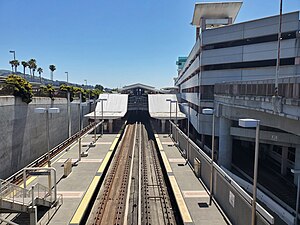
BART station
Daly City Yard in 2023
The Ocean View Branch right of way was reused to construct the Daly City Turnback and Yard in 1984–1988. The turnback added tail tracks and crossovers to allow more trains to reverse direction at Daly City station, while the yard added storage tracks and a maintenance facility.[21]San Mateo County voters approved plans for a Colma station in 1986 and 1988.[22] BART began negotiations with the county and its transit district about a potential Colma station in 1987. It was to serve as the first stage of the extension to San Francisco International Airport. The district paid BART $10 million in December 1989 as the initial payment on the extension. A $50 million Federal Transit Administration grant for the project was awarded in December 1991, followed by a $70 million grant in May 1992.[21] Initial construction began in May 1992.[23]
A $36.8 million construction contract for the station was awarded on February 11, 1993, followed by a $32.4 million contract for the garage on April 15, 1993.[21] Underground tail tracks south of the station were completed on November 5, 1993. The full project cost $170 million: $128 million in federal funds, $21 million in state funds, and $21 million from SamTrans. The station included a five-level, 1,400-space parking garage and a footbridge over the yard tracks to an additional surface lot.[23] The garage was constructed on air rights over the yard while the yard remained in use.[21] Colma station opened on February 24, 1996. It was the southern end of the BART system on the San Francisco Peninsula until the extension to the airport and Millbrae opened in 2003.[21] Colma station was "prominently featured" in the 2006 film Colma: The Musical.[24]
Notes
↑ Twentieth-century sources indicated that the station was built in 1881.[3][4] However, new evidence found in 2006 indicated it was built around 1863.[5]
↑ "A Message From Your Boardmembers"(PDF). News and Notes from the Colma Historical Association. No.29. Colma Historical Association. November 1996. p.1.
↑ "A Message From Your Board Members"(PDF). News and Notes from the Colma Historical Association. No.61. Colma Historical Association. April–June 2003. p.1.
↑ "A Message From Your Board Members"(PDF). News and Notes from the Colma Historical Association. No.64. Colma Historical Association. January–March 2004. p.1.
↑ "A Message From Your Board Members"(PDF). News and Notes from the Colma Historical Association. No.68. Colma Historical Association. January–March 2005. p.1.
This page is based on this Wikipedia article Text is available under the CC BY-SA 4.0 license; additional terms may apply. Images, videos and audio are available under their respective licenses.