Bay Fair station

Last updated
Bay Fair
Northbound train at Bay Fair station, October 2017.JPG
A northbound train at Bay Fair station in 2017
General information
Location15242 Hesperian Boulevard
San Leandro, California
Coordinates 37°41′49″N122°07′35″W / 37.697°N 122.1265°W / 37.697; -122.1265
Owned by San Francisco Bay Area Rapid Transit District
Line(s) BART A-Line
Platforms1 island platform
Tracks2
ConnectionsAiga bus trans.svg AC Transit: 10, 28, 35, 40, 93, 97, 706, 801
Construction
Structure typeElevated
Parking1,641 spaces
Bicycle facilities Racks, 40 lockers
AccessibleYes
ArchitectGwathmey, Sellier & Crosby
Joseph Esherick & Associates [1]
History
OpenedSeptember 11, 1972
Passengers
20242,441 (weekday average) [2]
Services
Preceding station Bart compact logo.svg Bay Area Rapid Transit Following station
San Leandro
toward Daly City
Blue Line Castro Valley
Green Line Hayward
San Leandro
toward Richmond
Orange Line
Location
Bay Fair station

Bay Fair station is a Bay Area Rapid Transit (BART) station located adjacent to the Bayfair Center mall in San Leandro, California. The station is served by the Orange, Green, and Blue lines.

Contents

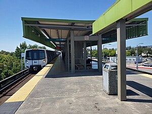
Bay Fair station has a single elevated island platform serving the line's two tracks. A pedestrian tunnel under the Union Pacific Railroad Oakland Subdivision tracks connects the fare lobby to parking areas south of the station. An AC Transit bus transfer area and additional parking are located on the north side of the station. [3]

History

The BART Board approved the name "Bay Fair" in December 1965. [4] The station opened on September 11, 1972, as part of the initial BART operating segment. [5] Due to a national strike that year by elevator constructors, elevator construction on the early stations was delayed. Elevators at most of the initial stations, including Bay Fair, were completed in the months following the opening. [6] [7] It became a transfer station on May 10, 1997, with the opening of the branch to Dublin/Pleasanton; a flying junction was built south of the station. [5]

Thirteen BART stations, including Bay Fair, did not originally have faregates for passengers using the elevator. In 2020, BART started a project to add faregates to elevators at these stations. The new faregate on the platform at Bay Fair was installed in July 2021. [8]

Related Research Articles

<span class="mw-page-title-main">Embarcadero station</span> Subway station in San Francisco, California, US

Embarcadero station is a combined BART and Muni Metro rapid transit subway station in the Market Street subway in downtown San Francisco. Located under Market Street between Drumm Street and Beale Street near The Embarcadero, it serves the Financial District neighborhood and surrounding areas. The three-level station has a large fare mezzanine level, with separate platform levels for Muni Metro and BART below. Embarcadero station opened in May 1976 – almost two years after service began through the Transbay Tube – as an infill station.

<span class="mw-page-title-main">Montgomery Street station</span> Rapid transit station in San Francisco, California, US

Montgomery Street station is a combined BART and Muni Metro rapid transit subway station in the Market Street subway in downtown San Francisco. Located under Market Street between Montgomery Street and Sansome Street, it serves the Financial District neighborhood and surrounding areas. The three-level station has a large fare mezzanine level, with separate platform levels for Muni Metro and BART below. Montgomery Street and Embarcadero station to the north are typically the two busiest stations in the BART system.

<span class="mw-page-title-main">Civic Center/UN Plaza station</span> Rapid transit station in San Francisco, California, US

Civic Center/UN Plaza station is a combined BART and Muni Metro rapid transit station in the Market Street subway in downtown San Francisco. Located under Market Street between 7th Street and 8th Street, it is named for the Civic Center neighborhood and the adjacent United Nations Plaza. The three-level station has a large fare mezzanine level, with separate platform levels for Muni Metro and BART below.

<span class="mw-page-title-main">West Oakland station</span> Rapid transit station in San Francisco Bay Area

West Oakland station is a Bay Area Rapid Transit (BART) station in the West Oakland neighborhood of Oakland, California. It has two elevated side platforms and is located near the eastern end of the Transbay Tube. All main BART lines except the Orange Line stop at the station. The Oakland Wye is located to the east of the station.

<span class="mw-page-title-main">12th Street Oakland City Center station</span> Rapid transit station in Oakland, California, US

12th Street/Oakland City Center station is an underground Bay Area Rapid Transit (BART) station located under Broadway between 12th Street and 14th Street in Downtown Oakland, adjacent to the Oakland City Center. The station has three underground levels, with tracks on the second and third levels. It is served by the Red Line, Orange Line, and Yellow Line, as well as by AC Transit buses on the surface.

<span class="mw-page-title-main">Lake Merritt station</span> Rapid transit station in Oakland, California, US

Lake Merritt station is an underground Bay Area Rapid Transit (BART) station located east of Downtown Oakland near the eponymous Lake Merritt. The station is served by the Orange, Green, and Blue lines. It is the nearest BART station to Chinatown, Laney College, and Jack London Square station.

<span class="mw-page-title-main">19th Street Oakland station</span> Metro station in Oakland, California, US

19th Street Oakland station is an underground Bay Area Rapid Transit (BART) station located under Broadway between 17th Street and 20th Street in the Uptown District of Oakland, California. It is a timed transfer point between northbound trains to Richmond and to Antioch. The station has three underground levels, with tracks on the second and third levels. It is served by the Red Line, Orange Line, and Yellow Line, as well as by AC Transit buses on the surface at the Uptown Transit Center.

<span class="mw-page-title-main">Fruitvale station</span> Rapid transit station in San Francisco Bay Area

Fruitvale station is a Bay Area Rapid Transit (BART) station located in the Fruitvale District of Oakland, California. The elevated station has two side platforms. The station is served by the Orange, Green, and Blue lines.

<span class="mw-page-title-main">Rockridge station</span> Metro station in Oakland, California, US

Rockridge station is a Bay Area Rapid Transit station located in the Rockridge district of Oakland, California. Located in the center median of the elevated State Route 24 west of the Caldecott Tunnel, the station has a single island platform serving two tracks. It is served by the Yellow Line.

<span class="mw-page-title-main">Orinda station</span> Rapid transit station in Orinda, California, US

Orinda station is a Bay Area Rapid Transit station in Orinda, California. The station has an island platform in the center median of State Route 24. It is served by the Yellow Line. An abstract mural by Win Ng, partially covered by advertisements, is located in the fare lobby.

<span class="mw-page-title-main">Walnut Creek station</span> Rapid transit station in San Francisco Bay Area

Walnut Creek station is an elevated Bay Area Rapid Transit (BART) station in Walnut Creek, California, served by the Yellow Line. The station is located north of downtown Walnut Creek, adjacent to Interstate 680 and near the Ygnacio Valley Road and California Boulevard arterial roads.

<span class="mw-page-title-main">Concord station (BART)</span> Rapid transit station in San Francisco Bay Area

Concord station is a Bay Area Rapid Transit (BART) station in Concord, California. The station is located between the downtown business district to the west and residential neighborhoods to the east. Concord station has a single elevated island platform and is served by the Yellow Line.

<span class="mw-page-title-main">San Leandro station</span> Rapid transit station in San Francisco Bay Area

San Leandro station is a Bay Area Rapid Transit (BART) station located off Davis Street in downtown San Leandro, California. The station has two elevated side platforms, with the faregates at ground level. The station is served by the Orange, Green, and Blue lines.

<span class="mw-page-title-main">MacArthur station (BART)</span> Rapid transit station in San Francisco Bay Area

MacArthur station is a Bay Area Rapid Transit (BART) station in the Temescal District of Oakland, California. It is the largest station in the BART system, being the only one with four platform tracks. Service through MacArthur is timed for cross-platform transfers between the southbound lines that pass through the station. MacArthur station is located in the median of SR 24 just north of its interchange with I-580. The station is perpendicular to 40th Street and MacArthur Boulevard. The surrounding neighborhood is mostly low-density residential, making MacArthur station primarily a commuting hub.

<span class="mw-page-title-main">Union City station</span> Metro station in Union City, California, US

Union City station is a Bay Area Rapid Transit (BART) station in Union City, California. The station sits near Decoto Road east of Alvarado-Niles Road, directly behind the James Logan High School campus. The station is served by the Orange and Green lines. Local bus service is provided by Union City Transit and AC Transit.

<span class="mw-page-title-main">North Berkeley station</span> Metro station in Berkeley, California, US

North Berkeley station is an underground Bay Area Rapid Transit (BART) station located in the North Berkeley neighborhood of Berkeley, California. It is bounded by Virginia Street, Sacramento Street, Delaware Street, and Acton Street in a residential area north of University Avenue. The main station entrance sits within a circular building at the center of a parking lot, while an elevator between the surface and the platform is located at the parking lot's Sacramento Street edge. The station is served by the Orange and Red lines.

<span class="mw-page-title-main">Hayward station (BART)</span> Metro station in Hayward, California, US

Hayward station is a Bay Area Rapid Transit (BART) station in Hayward, California, serving Downtown Hayward and the surrounding areas. It is served by the Orange and Green lines. The elevated station has two side platforms. A two-lane bus terminal is located on the northeast side of the station. A pedestrian tunnel under the Union Pacific Railroad Oakland Subdivision connects the fare lobby to a parking lot and a five-level parking garage.

<span class="mw-page-title-main">South Hayward station</span> Metro station in Hayward, California, US

South Hayward station is a Bay Area Rapid Transit (BART) station located off the Tennyson Road arterial in Hayward, California. It is served by the Orange and Green lines.

<span class="mw-page-title-main">El Cerrito Plaza station</span> Rapid transit station in El Cerrito, California, US

El Cerrito Plaza station is a Bay Area Rapid Transit (BART) station in El Cerrito, California, located adjacent to the El Cerrito Plaza shopping center. It primarily serves southern El Cerrito, northern Albany, and Kensington, along with nearby portions of Berkeley and Richmond. Nearly identical in form to El Cerrito del Norte station, El Cerrito Plaza station has two side platforms serving the line's two elevated tracks, with a fare lobby underneath. The Ohlone Greenway runs through the station area. The station is served by the Orange and Red lines.

<span class="mw-page-title-main">Oakland Coliseum station</span> Rail station in Oakland, California, US

The station complex of Amtrak's Oakland Coliseum station and Bay Area Rapid Transit (BART)'s Coliseum station is located in the East Oakland area of Oakland, California, United States. The two stations, located about 600 feet (180 m) apart, are connected to each other and to the Oakland Coliseum/Oakland Arena sports complex with an accessible pedestrian bridge. The BART station is served by the Orange, Green, and Blue lines; the Amtrak station is served by the Capitol Corridor service.

References

  1. Cerny, Susan Dinkelspiel (2007). An Architectural Guidebook to San Francisco and the Bay Area (1st ed.). Layton, UT: Gibbs Smith. pp. 501–502. ISBN   978-1-58685-432-4. OCLC   85623396.
  2. "Monthly Ridership Reports". San Francisco Bay Area Rapid Transit District. February 2024.
  3. "Transit Stops: Bay Fair Station" (PDF). Metropolitan Transportation Commission. July 5, 2016.
  4. "Names Approved for 38 Rapid Transit Stations Around Bay". Oakland Tribune. December 10, 1965. p. 10 via Newspapers.com.
  5. 1 2 "BART Chronology January 1947 – March 2009" (PDF). San Francisco Bay Area Rapid Transit District. March 2009. Archived from the original (PDF) on October 13, 2013.
  6. "Strike Delays Elevator Service at Some Stations". Oakland Tribune. September 10, 1972. p. 36 via Newspapers.com.
  7. "Four BART Lines Make The System". The Independent. February 26, 1973. p. 30 via Newspapers.com.
  8. "New Fare Gates & Station Hardening". San Francisco Bay Area Rapid Transit District. July 2023. Archived from the original on September 4, 2023.

Commons-logo.svg Media related to Bay Fair station at Wikimedia Commons