
Hayward is a city located in Alameda County, California in the East Bay subregion of the San Francisco Bay Area. With a population of 162,954 as of 2020, Hayward is the sixth largest city in the Bay Area and the third largest in Alameda County. Hayward was ranked as the 34th most populous municipality in California. It is included in the San Francisco–Oakland–San Jose Metropolitan Statistical Area by the US Census. It is located primarily between Castro Valley, San Leandro and Union City, and lies at the eastern terminus of the San Mateo–Hayward Bridge. The city was devastated early in its history by the 1868 Hayward earthquake. From the early 20th century until the beginning of the 1980s, Hayward's economy was dominated by its now defunct food canning and salt production industries.
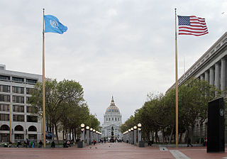
The Civic Center in San Francisco, California, is an area located a few blocks north of the intersection of Market Street and Van Ness Avenue that contains many of the city's largest government and cultural institutions. It has two large plazas and a number of buildings in classical architectural style. The Bill Graham Civic Auditorium, the United Nations Charter was signed in the Veterans Building's Herbst Theatre in 1945, leading to the creation of the United Nations. It is also where the 1951 Treaty of San Francisco was signed. The San Francisco Civic Center was designated a National Historic Landmark in 1987 and listed in the National Register of Historic Places on October 10, 1978.

Union Square is a historic intersection and surrounding neighborhood in Manhattan, New York City, located where Broadway and the former Bowery Road – now Fourth Avenue – came together in the early 19th century. Its name denotes that "here was the union of the two principal thoroughfares of the island". The current Union Square Park is bounded by 14th Street on the south, 17th Street on the north, and Union Square West and Union Square East to the west and east respectively. 17th Street links together Broadway and Park Avenue South on the north end of the park, while Union Square East connects Park Avenue South to Fourth Avenue and the continuation of Broadway on the park's south side. The park is maintained by the New York City Department of Parks and Recreation.
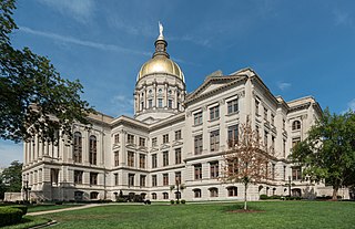
The Georgia State Capitol is an architecturally and historically significant building in Atlanta, Georgia, United States. The building has been named a National Historic Landmark which is listed on the National Register of Historic Places. As the primary office building of Georgia's government, the capitol houses the offices of the governor, lieutenant governor, and secretary of state on the second floor, chambers in which the General Assembly, consisting of the Georgia State Senate and Georgia House of Representatives, meets annually from January to April. The fourth floor houses visitors' galleries overlooking the legislative chambers and a museum located near the rotunda in which a statue of Miss Freedom caps the dome.

The current Ottawa City Hall is the city hall of Ottawa, Ontario, Canada. The downtown complex consists of two connected buildings: a modern wing located on Laurier Avenue and a 19th-century heritage wing located on Elgin Street. Although City Hall has frontage on two major streets, the main entrance is on Laurier Avenue, and the municipal address is 110 Laurier Avenue West.
The Main Street District of downtown Dallas, Texas runs along Main Street and is bounded by Elm Street one block north, Commerce St. one block south, N. Lamar St. to the west, and US 75/I-45 (I-345) elevated highway to the east. The district is the spine of downtown Dallas, and connects many of the adjoining business and entertainment districts. It does not include Dealey Plaza or the John Fitzgerald Kennedy Memorial which are a few blocks west in the West End Historic District.

Independence National Historical Park is a federally protected historic district in Philadelphia, Pennsylvania that preserves several sites associated with the American Revolution and the nation's founding history. Administered by the National Park Service, the 55-acre (22 ha) park comprises many of Philadelphia's most-visited historic sites within the Old City and Society Hill neighborhoods. The park has been nicknamed "America's most historic square mile" because of its abundance of historic landmarks.
Hoboken, New Jersey is home to many parks, historical landmarks, and other places of interest.

Boston City Hall is the seat of city government of Boston, Massachusetts. It includes the offices of the mayor of Boston and the Boston City Council. The current hall was built in 1968 to assume the functions of the Old City Hall.
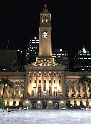
Brisbane City Hall, in Brisbane, Queensland, Australia, is the seat of the Brisbane City Council. It is located adjacent to King George Square, where the rectangular City Hall has its main entrance. The City Hall also has frontages and entrances in both Ann Street and Adelaide Street. The building design is based on a combination of the Roman Pantheon, and St Mark's Campanile in Venice and is considered one of Brisbane's finest buildings. It was listed on the Register of the National Estate in 1978 and on the Queensland Heritage Register in 1992. It is also iconic for its Westminster chimes which sound on the quarter-hour.

The Civic Center is the area and neighborhood of Lower Manhattan, Manhattan, New York City, that encompasses New York City Hall, One Police Plaza, the courthouses in Foley Square, the Metropolitan Correctional Center and the surrounding area. The district is bound on the west by Tribeca at Broadway, on the north by Chinatown at Worth Street or Bayard Street, on the east by the East River and the Brooklyn Bridge at South Street, and on the south by the Financial District at Ann Street.

Downtown Hayward is the original and current central business district of Hayward, California, United States, and is home to the current Hayward City Hall, along with the two previous city halls, Alex Giualini Plaza and the City Center Building. The Hayward Fault runs through the area, and is the cause of the two previous city halls being taken out of use.
Hayward City Hall is the third and current Hayward city hall building, located in downtown Hayward, California, United States, next to the Hayward BART Station. The city hall opened in January 1998, replacing the abandoned City Center Building, which served as Hayward's city hall for 29 years from 1969 to 1998. Hayward's first city hall, which is also closed to the public, is now in the Alex Giualini Plaza, three blocks away.

The City Center Building, known briefly as Centennial Tower, was the tallest building in Hayward, California. It was previously the second tallest, until the 2013 razing of Warren Hall on the Cal State East Bay campus. It was for many years an abandoned building, located between Foothill Boulevard and City Center Drive, in the City Center section of Downtown Hayward, adjacent to the PlazaCenter mall. It was formerly used as Hayward City Hall.

Downtown Santa Ana (DTSA), also called Downtown Orange County, is the historic city center of Santa Ana, the county seat of Orange County, California. It is the institutional center for the city of Santa Ana as well as Orange County, a retail and business hub, and has in recent years developed rapidly as a regional cultural, entertainment and culinary center for Orange County.

San José City Hall is the seat of the municipal government of San Jose, California. Located in Downtown San Jose, it was designed by Pritzker Prize-winning architect Richard Meier in a Postmodern style. It consists of an 18-story tower, an iconic glass rotunda, and a city council chamber wing, laid out within a two-block-long public square known as San José Civic Plaza. The tower rises 285 feet (87 m) above the plaza, making it the second tallest building in San Jose.

El Pueblo de Los Ángeles Historical Monument, also known as Los Angeles Plaza Historic District and formerly known as El Pueblo de Los Ángeles State Historic Park, is a historic district taking in the oldest section of Los Angeles, known for many years as El Pueblo de Nuestra Señora la Reina de los Ángeles del Río de Porciúncula. The district, centered on the old plaza, was the city's center under Spanish (1781–1821), Mexican (1821–1847), and United States rule through most of the 19th century. The 44-acre park area was designated a state historic monument in 1953 and listed on the National Register of Historic Places in 1972.
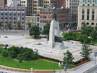
Confederation Square is an urban square in Ottawa, Ontario, Canada, and is considered the second most important ceremonial centre in Canada's capital city, after Parliament Hill. Roughly triangular in area, with Canada's National War Memorial at its centre and the Valiants Memorial at its periphery, the square is bounded by Wellington Street to the north and branches of Elgin Street to the east and west.


