
San Francisco Bay is a large tidal estuary in the U.S. state of California, and gives its name to the San Francisco Bay Area. It is dominated by the cities of San Francisco, San Jose, and Oakland.

Hayward is a city located in Alameda County, California in the East Bay subregion of the San Francisco Bay Area. With a population of 162,954 as of 2020, Hayward is the sixth largest city in the Bay Area and the third largest in Alameda County. Hayward was ranked as the 34th most populous municipality in California. It is included in the San Francisco–Oakland–San Jose Metropolitan Statistical Area by the US Census. It is located primarily between Castro Valley, San Leandro and Union City, and lies at the eastern terminus of the San Mateo–Hayward Bridge. The city was devastated early in its history by the 1868 Hayward earthquake. From the early 20th century until the beginning of the 1980s, Hayward's economy was dominated by its now defunct food canning and salt production industries.

Mt. Eden was an unincorporated agricultural district in Eden Township, Alameda County, California, United States. It was annexed by the City of Hayward. It lies at an elevation of 43 feet.

Don Edwards San Francisco Bay National Wildlife Refuge (DESFBNWR) is a United States National Wildlife Refuge located in the southern part of San Francisco Bay, California. The Refuge headquarters and visitor center is located in the Baylands district of Fremont, next to Coyote Hills Regional Park, in Alameda County. The visitor center is on Marshlands Rd, off Thornton Ave.

Bair Island is a marsh area in Redwood City, California, covering 3,000 acres (1,200 ha), and includes three islands: Inner, Middle and Outer islands. Bair Island is part of the larger Don Edwards San Francisco Bay National Wildlife Refuge. It is surrounded by the Steinberger slough to the northwest and Redwood Creek to the southeast.

Located in northern California, the Suisun Marsh has been referred to as the largest brackish water marsh on west coast of the United States of America. The marsh land is part of the San Francisco Bay tidal estuary, and subject to tidal ebb and flood. The marsh is home to many species of birds and other wildlife, and is formed by the confluence of the Sacramento and San Joaquin rivers between Martinez and Suisun City, California and several other smaller, local watersheds. Adjacent to Suisun Bay, the marsh is immediately west of the legally defined Sacramento-San Joaquin Delta as well as part of the San Francisco Bay estuary.

Alameda Creek is a large perennial stream in the San Francisco Bay Area. The creek runs for 45 miles (72 km) from a lake northeast of Packard Ridge to the eastern shore of San Francisco Bay by way of Niles Canyon and a flood control channel. Along its course, Alameda Creek provides wildlife habitat, water supply, a conduit for flood waters, opportunities for recreation, and a host of aesthetic and environmental values. The creek and three major reservoirs in the watershed are used as water supply by the San Francisco Public Utilities Commission, Alameda County Water District and Zone 7 Water Agency. Within the watershed can be found some of the highest peaks and tallest waterfall in the East Bay, over a dozen regional parks, and notable natural landmarks such as the cascades at Little Yosemite and the wildflower-strewn grasslands and oak savannahs of the Sunol Regional Wilderness. After an absence of half a century, ocean-run steelhead trout will soon be able to return to Alameda Creek to mingle with remnant rainbow trout populations. Completion of a series of dam removal and fish passage projects, along with improved stream flows for cold-water fish and planned habitat restoration, will improve and restore habitat conditions for migratory fish. Steelhead trout and Chinook salmon will soon be able to access up to 20 miles (32 km) of spawning and rearing habitat in Alameda Creek and its tributaries.

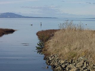
Hayward Regional Shoreline is a regional park located on the shores of the San Francisco Bay in Hayward, California. It is part of the East Bay Regional Parks system. The 1,713 acre park extends to the shores of San Lorenzo. Part of the park is former commercial salt flats purchased in 1996. A former landfill, now capped with soil and plants, is located in the park. The park includes the 250 acre tidal wetland, Cogswell Marsh, and the 364 acre Oro Loma Marsh. Located to the south of the park is the Hayward Shoreline Interpretive Center, which provides information on the Bay shore habitats. The San Francisco Bay Trail runs through the park, which connects the park with San Lorenzo Creek.

Elkhorn Slough is a 7-mile-long (11 km) tidal slough and estuary on Monterey Bay in Monterey County, California. It is California's second largest estuary and the United States' first estuarine sanctuary. The community of Moss Landing and the Moss Landing Power Plant are located at the mouth of the slough on the bay.
The Dotson Family Marsh, formerly Breuner Marsh, is a 238-acre regional park on San Pablo Bay in the East San Francisco Bay Area city of Richmond, California, In 2009 the East Bay Regional Parks District acquired the Breuner Marsh site, adding it to Point Pinole Regional Shoreline. A habitat restoration plan for 60 acres of wetlands and 90 acres of California coastal prairie was subsequently approved.
The Leslie Salt Company was a salt-producing company located in the San Francisco Bay Area, at the current locations of Newark, Hayward and other parts of the bay.
Roberts Landing was a settlement in Alameda County, California, now incorporated into the town of San Leandro. It is located at the mouth of San Lorenzo Creek on San Francisco Bay just west of the community of San Lorenzo. In the 19th century, it had warehouses and a wharf, and was used by farmers to ship their produce to the city of San Francisco. From 1906 to 1964, it was the site of an explosives manufacturing plant operated by the Trojan Powder Company. Following the plant's closure, the site was decontaminated. After protracted discussions, part was made into a housing development while a larger part was made an open space that is now also called the San Leandro Shoreline Marshlands.
San Elijo Lagoon Ecological Reserve is one of the largest remaining coastal wetlands in San Diego County, California, United States.
Moss Landing Wildlife Area is a California State wildlife preserve on the shore of Elkhorn Slough.

The Hayward Shoreline Interpretive Center is a natural history and ecology interpretive nature center located in Hayward, California. It is directly adjacent to the north side of Highway 92 as it approaches the San Mateo–Hayward Bridge, and is accessed from the highway by the last offramp in the westbound direction before the bridge toll gates. The Center was dedicated in 1986, and is operated by the Hayward Area Recreation and Park District.
Oliver Salt Company was a saltworks located on the San Francisco Bay adjacent to Hayward, California, which produced salt by evaporation from the San Francisco Bay Area. The remains of their facilities are within Eden Landing Ecological Reserve.

Belmont Slough is a slough on the western shore of San Francisco Bay separating Redwood Shores and Foster City. It provides estuarine and marine deepwater habitats in its subtidal waters, which are characterized as brackish and saltwater.

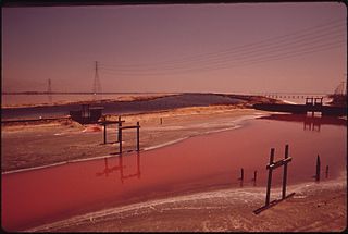
The San Francisco Bay Salt Ponds are an approximately 16,500-acre (6,700 ha) part of the San Francisco Bay that have been used as salt evaporation ponds since the California Gold Rush era. Most of the ponds were once wetlands in the cities of Redwood City, Newark, Hayward and other parts of the bay.

Bull Island is an island in the Napa River, in Napa County, California. From the 1880s onward, it was owned by the Money family, who constructed levees and reclaimed the land, using it to farm grain and potatoes. It was described as a "fine ranch" in 1918. After a levee failure in 1954, it gradually eroded into the water, becoming a salt marsh; for some time afterward, it was used as an evaporation pond for the industrial production of salt by the Leslie Salt Company. Beginning in the 1970s, Bull Island was proposed for inclusion in a variety of riparian preservation projects, but none came to fruition. However, in 1997, the Money family sold it to the California State Lands Commission, who turned it into a wildlife habitat; today it is administered as part of the Fagan Marsh Ecological Reserve, and hosts animals of numerous endangered species.
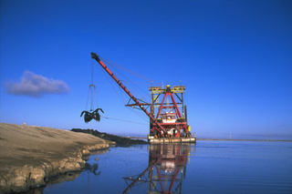
Mallard II is a wooden-hulled clamshell dredger used to maintain levees on the San Francisco Bay Salt Ponds. Mallard II was constructed in 1936, and is "probably the oldest operating dredge in California"; she is owned and operated by Cargill Salt.

