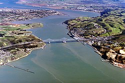
Carquinez Bridge

Last updated
Carquinez Bridge
CarquinezBridge2022.jpg
The Carquinez Bridge in 2022: (from closest to furthest) a 2003 suspension bridge and the 1958 cantilever bridge
Coordinates 38°03′39″N122°13′33″W / 38.0608°N 122.2257°W / 38.0608; -122.2257
Carries8 lanes of I-80 (1961).svg I-80, pedestrians and bicycles.
Crosses Carquinez Strait
Locale Crockett and Vallejo, California, U.S.
Official name Alfred Zampa Memorial Bridge (suspension bridge only)
Other name(s)Zampa Bridge, Vallejo Bridge
Owner State of California
Maintained by California Department of Transportation and the Bay Area Toll Authority
ID number 28+0352 (2003 span), 23+0015L (1927 span), 23+0015R (1958 span)
Website www.bayareafastrak.org
Characteristics
Design Cantilever bridge (Eastbound)
Suspension bridge (Westbound)
Total length3,465 feet (1,056 m) or 0.66 miles (1.06 km) (suspension bridge), 3,300 feet (1,000 m) (cantilever bridge)
Width84 feet (26 m) (suspension deck), 52 feet (16 m) (cantilever deck)
Height410 feet (120 m) (suspension tower)
Longest span2,387 feet (728 m) (suspension span)
Clearance below 148 feet (45 m) (suspension bridge), 140 feet (43 m) (cantilever bridge)
History
OpenedMay 21, 1927;96 years ago (1927-05-21) (original span)
November 25, 1958;65 years ago (1958-11-25) (eastbound)
November 11, 2003;20 years ago (2003-11-11) (westbound)
ClosedSeptember 4, 2007 (2007-Sep-04) (original span)
Statistics
Toll
  • Eastbound only
  • FasTrak or pay-by-plate, cash not accepted
  • Effective January 1, 2022 – December 31, 2024 (2022-01-01 2024-12-31):
  • $7.00
  • $3.50 (carpool rush hours, FasTrak only)
Location
Carquinez Bridge

The Carquinez Bridge is a pair of parallel bridges spanning the Carquinez Strait at the northeastern end of San Francisco Bay. They form the part of Interstate 80 between Crockett and Vallejo, California, United States.

Contents

The name Carquinez Bridge originally referred to a single cantilever bridge built in 1927, which was part of the direct route between San Francisco and Sacramento. A second parallel cantilever bridge was completed in 1958 to deal with the increased traffic.

Later, seismic problems made the 1927 span unsafe in case of an earthquake, and led to the construction, and 2003 opening, of a replacement: a suspension bridge officially named the Alfred Zampa Memorial Bridge, in memory of iron worker Al Zampa, who played an integral role in the construction of numerous San Francisco Bay Area bridges. The Alfred Zampa Memorial Bridge carries southbound traffic from Vallejo to Crockett, and the 1958 cantilever span carries northbound traffic.

History and description

The first regular crossing of the Carquinez Strait began in the mid-1800s as a ferry operated between the cities of Benicia and Martinez, six miles upstream from the bridge site. Auto service started on this route in 1913. A train ferry operated between Benicia and Porta Costa from 1879 until 1930 when a rail bridge opened. Ferry service at the site of the bridge started in 1913 by the Rodeo-Vallejo Ferry Company. [1]

Original span (1927–2007)

The original steel cantilever bridge was designed by Robinson & Steinman and dedicated on May 21, 1927. Prior to this, crossing the Carquinez Strait necessitated the use of ferries. The bridge cost $8 million to build. It was the first major crossing of the San Francisco Bay [2] and a significant technological achievement in its time.

Upon its completion, the span became part of the Lincoln Highway. This historic transcontinental roadway's original alignment, like the Transcontinental Railroad that preceded it nearly sixty years earlier, chose to avoid crossing the Carquinez Strait entirely. The preferred option, given the engineering limitations of the day, was to skirt around the Delta by going south from Sacramento through Stockton, then proceeding west across the San Joaquin River and over the Altamont Pass, and finally reaching Oakland from the south; a route that would later become U.S. Route 50 and ultimately Interstates 5, 205, and 580. This circuitous route, several miles longer, and traversing a rather formidable mountain pass, was preferable to crossing the Carquinez Strait, a deep channel with strong currents and frequent high winds. For decades, building a bridge across the Carquinez Strait was considered prohibitively expensive and technologically risky. Once the bridge was built however, driving from Sacramento to the East Bay became much more direct. The Carquinez Bridge provided a welcome alternative route from the Central Valley to the Bay Area, one that no longer required loading one's vehicle onto and off of a ferry. With the bridge completed, the Lincoln Highway was realigned to cross the Sacramento River, then proceed southwest through Davis and Vallejo, across the Carquinez Bridge, and along the shores of the San Pablo and San Francisco bays to Richmond and Oakland; becoming U.S. Route 40, and ultimately Interstate 80.

After the Loma Prieta earthquake engineers determined that the aging 1927 span was seismically unstable, and that a retrofit was impossible. The decision was made to replace it with a new suspension bridge. The 1927 span was temporarily used to hold eastbound traffic while the 1958 eastbound span underwent a seismic retrofit, deck and superstructure rehabilitation, and painting to extend its serviceable life. [3] The old 1927 cantilever bridge was dismantled three years after the opening of its replacement; with completion on September 4, 2007. A 3,000-pound bronze bell atop one of the bridge piers was removed and placed into storage. The bell will eventually be displayed in a new museum to be built at the Oakland end of the San Francisco–Oakland Bay Bridge.

Parallel span (1958)

At a cost of $38 million [4] a parallel bridge was built just east of the 1927 bridge. The new bridge carried all traffic for a few months after it opened in November 1958, then after new ramps were built, the three-lane 1927 span, originally two-way, served westbound traffic while the four-lane 1958 span handled eastbound traffic.

Alfred Zampa Memorial Bridge (2003 replacement span)

At a cost of $240 million a new suspension bridge was built, to the west of the two earlier bridges, by the joint venture consisting of Flatiron Structures of Longmont, Co., FCI Constructors of Benicia, Ca., and the Cleveland Bridge & Engineering Company of Darlington, England. [4] [5]

This new bridge was named the Alfred Zampa Memorial Bridge, after an ironworker who worked on a number of the San Francisco Bay Area bridges, including the Golden Gate Bridge, and the original 1927 Carquinez span. The bridge was dedicated on November 8, 2003, and opened for traffic on November 11, 2003. Originally, the plan was to dedicate the bridge on November 15, but complications involving then just-recalled Governor Gray Davis and the transfer of power to Arnold Schwarzenegger resulted in the date being moved. The coins minted to commemorate the event have the original date on them. [6]

The new suspension bridge, consists of the south anchorage, a transition pier, the South and North towers, and the north anchorage. It has spans of 147 m, 728 m, and 181 m. for a total span of 0.66 miles (1,060 m). It features a pedestrian and bicycle path, part of a bike trail which it is hoped will eventually circle the entire Bay Area. The towers are each founded on two footings, which are each supported by six vertical, 3-metre-diameter (9.8 ft) steel shells infilled with reinforced concrete, followed by 2.7-metre-diameter (8.9 ft) drilled shafts in rock, i.e., cast-in-drilled hole, or CIDH, piles. The total length of the CIDH pile at the South Tower is approximately 89 m, with about 43 m of drilled shaft in rock. The total length of the CIDH pile at the North Tower ranges from 49 to 64 m, with about 16 to 26 m of drilled shaft in rock. The design parameters used for the South Tower piles were later confirmed by a pile load test. Additional field investigations during construction revealed significant variations in rock conditions at the North Tower, resulting in the redesign of the length of the piles. Major construction challenges encountered during construction of the South Tower piles, and the revised construction procedure, i.e., under-reaming, used by the constructor to mitigate caving.

Materials for the New Bridge came from all over the world:

Tolls

Tolls are collected only from automotive traffic headed eastbound, towards Vallejo at the toll plaza on the north side of the bridge. Although the 2003 Alfred Zampa Memorial Bridge is the newer span, no toll is charged in that direction, continuing the practice of the now-demolished 1927 span. All-electronic tolling has been in effect since 2020, and drivers may either pay using the FasTrak electronic toll collection device, using the license plate tolling program, or via a one time payment online. Effective January 1, 2022 – December 31, 2024, the toll rate for passenger cars is $7. During peak traffic hours, carpool vehicles carrying three or more people, clean air vehicles, or motorcycles may pay a discounted toll of $3.50 if they have FasTrak and use the designated carpool lane. Drivers must pay within 48 hours after crossing the bridge or they will be sent a toll violation invoice. No additional fees will be added to the toll violation if it is paid within 21 days. [7]

Historical toll rates

Crossing the original 1927 bridge required a toll, but tolls were removed soon after the state bought the bridge in 1940. Tolls in 1926 were originally set at $0.60 per car plus $0.10 per passenger. This was reduced in 1938 to $0.45 per car plus $0.05 per passenger. After the state took ownership, tolls were immediately reduced to $0.30 per car. In 1942, tolls were further reduced to $0.25 before being removed in 1945. Tolls were reinstated in 1958 with the completion of the parallel span, set again at $0.25. It was increased to $0.35 in 1970, and then $0.40 in 1978. [8]

The basic toll (for automobiles) on the seven state-owned bridges, including the Carquinez Bridge, was raised to $1 by Regional Measure 1, approved by Bay Area voters in 1988. [9] A $1 seismic retrofit surcharge was added in 1998 by the state legislature, originally for eight years, but since then extended to December 2037 (AB1171, October 2001). [10] On March 2, 2004, voters approved Regional Measure 2, raising the toll by another dollar to a total of $3. An additional dollar was added to the toll starting January 1, 2007, to cover cost overruns concerning the replacement of the eastern span.

The Metropolitan Transportation Commission, a regional transportation agency, in its capacity as the Bay Area Toll Authority, administers RM1 and RM2 funds, a significant portion of which are allocated to public transit capital improvements and operating subsidies in the transportation corridors served by the bridges. Caltrans administers the "second dollar" seismic surcharge, and receives some of the MTC-administered funds to perform other maintenance work on the bridges. The Bay Area Toll Authority is made up of appointed officials put in place by various city and county governments, and is not subject to direct voter oversight. [11]

Due to further funding shortages for seismic retrofit projects, the Bay Area Toll Authority again raised tolls on all seven of the state-owned bridges in July 2010. The toll rate for autos on the Carquinez Bridge was thus increased to $5. [12]

In June 2018, Bay Area voters approved Regional Measure 3 to further raise the tolls on all seven of the state-owned bridges to fund $4.5 billion worth of transportation improvements in the area. [13] [14] Under the passed measure, the toll rate for autos on the Carquinez Bridge will be increased to $6 on January 1, 2019; to $7 on January 1, 2022; and then to $8 on January 1, 2025. [15]

In September 2019, the MTC approved a $4 million plan to eliminate toll takers and convert all seven of the state-owned bridges to all-electronic tolling, citing that 80 percent of drivers are now using Fastrak and the change would improve traffic flow. [16] On March 20, 2020, accelerated by the COVID-19 pandemic, all-electronic tolling was placed in effect for all seven state-owned toll bridges. [17] The MTC then installed new systems at all seven bridges to make them permanently cashless by the start of 2021. [18] In April 2022, the Bay Area Toll Authority announced plans to remove all remaining unused toll booths and create an open-road tolling system which functions at highway speeds. [19]

See also

Related Research Articles

<span class="mw-page-title-main">Dumbarton Bridge (California)</span> Southernmost bridge crossing the San Francisco Bay

The Dumbarton Bridge is the southernmost of the highway bridges across San Francisco Bay in California. Carrying over 70,000 vehicles and about 118 pedestrian and bicycle crossings daily, it is the shortest bridge across San Francisco Bay at 1.63 miles. Its eastern end is in Fremont, near Newark in the San Francisco Bay National Wildlife Refuge, and its western end is in Menlo Park. Bridging State Route 84 across the bay, it has three lanes each way and a separated bike/pedestrian lane along its south side. Like the San Mateo Bridge to the north, power lines parallel the bridge.

<span class="mw-page-title-main">Golden Gate Bridge</span> San Francisco Bay suspension bridge

The Golden Gate Bridge is a suspension bridge spanning the Golden Gate, the one-mile-wide (1.6 km) strait connecting San Francisco Bay and the Pacific Ocean. The structure links the U.S. city of San Francisco, California—the northern tip of the San Francisco Peninsula—to Marin County, carrying both U.S. Route 101 and California State Route 1 across the strait. It also carries pedestrian and bicycle traffic, and is designated as part of U.S. Bicycle Route 95. Recognized by the American Society of Civil Engineers as one of the Wonders of the Modern World, the bridge is one of the most internationally recognized symbols of San Francisco and California.

<span class="mw-page-title-main">San Francisco–Oakland Bay Bridge</span> Complex of bridges spanning San Francisco Bay

The San Francisco–Oakland Bay Bridge, known locally as the Bay Bridge, is a complex of bridges spanning San Francisco Bay in California. As part of Interstate 80 and the direct road between San Francisco and Oakland, it carries about 260,000 vehicles a day on its two decks. It includes one of the longest bridge spans in the United States.

<span class="mw-page-title-main">Interstate 780</span> Interstate Highway in California

Interstate 780 (I-780) is an east–west auxiliary Interstate Highway in the San Francisco Bay Area of Northern California. It runs from Curtola Parkway and Lemon Street in Vallejo to I-680 just north of the Benicia–Martinez Bridge in Benicia. It closely parallels the Carquinez Strait for its entire route. Originally, this segment was part of I-680 before that Interstate was extended and rerouted to Fairfield. The city-maintained Curtola Parkway continues west from I-80 to State Route 29 (SR 29) in Vallejo.

<span class="mw-page-title-main">Interstate 680 (California)</span> Interstate highway in California

Interstate 680 (I-680) is a north–south auxiliary Interstate Highway in Northern California. It curves around the eastern cities of the San Francisco Bay Area from San Jose to I-80 at Fairfield, bypassing cities along the eastern shore of San Francisco Bay such as Oakland and Richmond while serving others more inland such as Pleasanton and Concord.

<span class="mw-page-title-main">Carquinez Strait</span> Tidal strait in Northern California

The Carquinez Strait is a narrow tidal strait located in the Bay Area of Northern California, United States. It is part of the tidal estuary of the Sacramento and the San Joaquin rivers as they drain into the San Francisco Bay. The strait is eight miles (13 km) long and connects Suisun Bay, which receives the waters of the combined rivers, with San Pablo Bay, a northern extension of the San Francisco Bay.

<span class="mw-page-title-main">California State Route 37</span> Highway in California

State Route 37 is a state highway in the U.S. state of California that runs 21 miles (34 km) along the northern shore of San Pablo Bay. It serves as a vital connection in the North Bay region of the San Francisco Bay Area, running from U.S. Route 101 in Novato, through northeastern Marin County, and the southern tips of both Sonoma and Solano Counties to Interstate 80 in Vallejo. Sonoma Raceway and Six Flags Discovery Kingdom are accessible from Highway 37.

<span class="mw-page-title-main">Richmond–San Rafael Bridge</span> Bridge crossing the San Francisco Bay

The Richmond–San Rafael Bridge is the northernmost of the east–west crossings of California's San Francisco Bay, carrying Interstate 580 from Richmond on the east to San Rafael on the west. It opened in 1956, replacing ferry service by the Richmond–San Rafael Ferry Company, and was officially renamed in 1981 to honor California State Senator John F. McCarthy, who championed the bridge's creation.

<span class="mw-page-title-main">Benicia–Martinez Bridge</span> Bridge in California, U.S.

The Benicia–Martinez Bridge refers to three parallel bridges which cross the Carquinez Strait just west of Suisun Bay in California; the spans link Benicia on the north side with Martinez on the south.

<span class="mw-page-title-main">Antioch Bridge</span> Overpass on the San Joaquin River

The Antioch Bridge is an automobile, bicycle, and pedestrian bridge in the western United States. Located in northern California, it crosses the San Joaquin River-Stockton Deepwater Shipping Channel, linking Antioch in Contra Costa County with Sherman Island in southern Sacramento County, near Rio Vista.

<span class="mw-page-title-main">Eastern span replacement of the San Francisco–Oakland Bay Bridge</span> Seismic stabilization megaproject in California (2002–2013)

The eastern span replacement of the San Francisco–Oakland Bay Bridge was a construction project to replace a seismically unsound portion of the Bay Bridge with a new self-anchored suspension bridge (SAS) and a pair of viaducts. The bridge is in the U.S. state of California and crosses the San Francisco Bay between Yerba Buena Island and Oakland. The span replacement took place between 2002 and 2013, and is the most expensive public works project in California history, with a final price tag of $6.5 billion, a 2,500% increase from the original estimate of $250 million, which was an initial estimate for a seismic retrofit of the span, not the full span replacement ultimately completed. Originally scheduled to open in 2007, several problems delayed the opening until September 2, 2013. With a width of 258.33 ft (78.74 m), comprising 10 general-purpose lanes, it is the world's widest bridge according to Guinness World Records.

The Metropolitan Transportation Commission (MTC) is the government agency responsible for regional transportation planning and financing in the San Francisco Bay Area. It was created in 1970 by the State of California, with support from the Bay Area Council, to coordinate transportation services in the Bay Area's nine counties: Alameda, Contra Costa, Marin, Napa, San Francisco, San Mateo, Santa Clara, Solano, and Sonoma. The MTC is fourth most populous metropolitan planning organization in the United States.

<span class="mw-page-title-main">U.S. Route 101 in California</span> U.S. Highway in California

U.S. Route 101 (US 101) is a major north–south United States Numbered Highway, stretching from Los Angeles, California, to Tumwater, Washington. The California portion of US 101 is one of the last remaining and longest U.S. Routes still active in the state, and the longest highway of any kind in California. US 101 was also one of the original national routes established in 1926. Significant portions of US 101 between the Los Angeles area and the San Francisco Bay Area follow El Camino Real, the commemorative route connecting the former Alta California's 21 missions.

<span class="mw-page-title-main">Interstate 80 in California</span> Section of Interstate Highway in California, United States

Interstate 80 (I-80) is a transcontinental Interstate Highway in the United States, stretching from San Francisco, California, to Teaneck, New Jersey. The segment of I-80 in California runs east from San Francisco across the San Francisco–Oakland Bay Bridge to Oakland, where it turns north and crosses the Carquinez Bridge before turning back northeast through the Sacramento Valley. I-80 then traverses the Sierra Nevada, cresting at Donner Summit, before crossing into the state of Nevada within the Truckee River Canyon. The speed limit is at most 65 mph (105 km/h) along the entire route instead of the state's maximum of 70 mph (110 km/h) as most of the route is in either urban areas or mountainous terrain. I-80 has portions designated as the Eastshore Freeway and Alan S. Hart Freeway.

<span class="mw-page-title-main">Al Zampa</span> American iron worker (1905–2000)

Alfred Zampa was an American iron worker who played a role in the construction of numerous San Francisco Bay Area bridges during the early twentieth century. He was most notable for being one of the first people to survive falling off the Golden Gate Bridge. He was a charter member of the Half Way to Hell Club, whose members are the men who fell from the Golden Gate Bridge and were saved by the nets.

Selby is an unincorporated community in Contra Costa County, in the East Bay region of the San Francisco Bay Area in northern California.

The Bay Area Toll Authority (BATA) is a state agency created by the California State Legislature in 1997 to administer the auto tolls on the San Francisco Bay Area's seven state-owned toll bridges. On January 1, 1998, the Metropolitan Transportation Commission (MTC) — the transportation planning, financing and coordinating agency for the nine-county region — began operations as BATA. In August 2005, the California Legislature expanded BATA's responsibilities to include administration of all toll revenue and joint oversight of the toll bridge construction program with Caltrans and the California Transportation Commission.

<span class="mw-page-title-main">John V. Robinson</span> American writer and photojournalist (born 1960)

John V. Robinson is an American writer and photojournalist who specializes in photographing heavy construction work with a focus on bridge construction and the men and women who do the work. Robinson goes onto construction sites and does detailed photo essays of the iron workers, pile drivers, carpenters, laborers, and crane operators who do this demanding and dangerous work. He frequently collects oral histories of the workers.

<span class="mw-page-title-main">Half Way to Hell Club</span> Informal iron workers group

The Half Way to Hell Club was an exclusive club organized by the men who fell from the Golden Gate Bridge during its construction in 1936 and 1937 and were saved by the safety nets. One of the club's earliest members was Iron Worker Al Zampa who fell into the safety nets in October 1936.

<span class="mw-page-title-main">San Mateo–Hayward Bridge</span> Road bridge across San Francisco Bay in California, United States

The San Mateo–Hayward Bridge is a bridge crossing the American state of California's San Francisco Bay, linking the San Francisco Peninsula with the East Bay. The bridge's western end is in Foster City, a suburb on the eastern edge of San Mateo. The eastern end of the bridge is in Hayward. It is the longest fixed-link bridge in California and the 25th longest in the world by length. The bridge is owned by the state of California, and is maintained by California Department of Transportation (Caltrans), the state highway agency. Further oversight is provided by the Bay Area Toll Authority (BATA).

References

  1. "Toll Tags - FAQs - FasTrak". www.bayareafastrak.org. Retrieved 2021-07-29.
  2. The Barrier Broken – Vallejo Evening Chronicle, May 21, 1927
  3. "Old Carquinez Bridge is disappearing" – San Francisco Chronicle, April 25, 2006.
  4. 1 2 "Bay Area Toll Authority – Bridge Facts – Carquinez Bridge". Bata.mtc.ca.gov. 2011-01-27. Archived from the original on 2011-08-09. Retrieved 2011-08-21.
  5. "Cleveland Bridge nets US suspension bridge". New Civil Engineer. 20 January 2000. Retrieved 18 September 2021.
  6. "Alfred Zampa memorial coins" [ full citation needed ] Archived October 7, 2007, at the Wayback Machine – Official Web Site
  7. "Carquinez Bridge". www.bayareafastrak.org. CalTrans. Retrieved July 10, 2022.
  8. "History of California's Bridge Tolls" (PDF). Caltrans . Retrieved June 3, 2018.
  9. Regional Measure 1 Toll Bridge Program. bata.mtc.ca.gov; Bay Area Toll Authority. Archived November 4, 2010, at the Wayback Machine
  10. Dutra, John (October 14, 2001). "AB 1171 Assembly Bill – Chaptered". California State Assembly. Archived from the original on March 15, 2012. Retrieved August 7, 2008.
  11. "About MTC". Metropolitan Transportation Commission. October 15, 2009. Archived from the original on November 3, 2010. Retrieved October 15, 2009.
  12. "Frequently Asked Toll Questions". Bay Area Toll Authority. June 1, 2010. Archived from the original on November 22, 2010. Retrieved June 29, 2010.
  13. Cabanatuan, Michael (June 6, 2018). "Regional Measure 3: Work on transportation improvements could start next year". SFGate.com.
  14. Kafton, Christien (November 28, 2018). "Bay Area bridge tolls to increase one dollar in January, except Golden Gate". KTVU.
  15. "Tolls on Seven Bay Area Bridges Set to Rise Next Month" (Press release). Metropolitan Transportation Commission. December 11, 2018. Retrieved December 16, 2018.
  16. Smith, Darrell (September 7, 2019). "Do you drive to the Bay Area? A big change is coming to toll booths at the bridges". The Sacramento Bee. Retrieved April 12, 2020.
  17. "Cash Toll Collection Suspended at Bay Area Bridges". Metropolitan Transportation Commission. March 20, 2020. Retrieved March 20, 2020.
  18. "New Year Brings New Toll Collection System to Bay Area Bridges". Metropolitan Transportation Commission. December 28, 2020. Retrieved December 28, 2020.
  19. Cabanatuan, Michael (10 April 2022). "Bay Area toll collectors are gone, so what happens to the tollbooths? Here's the $77 million answer". San Francisco Chronicle. Retrieved 12 April 2022.
  20. "California Rework - Road Network #1".